Wright County sits northwest of the Twin Cities and combines fast-growing communities, older county centers, river corridors, and a dense lake district. Buffalo provides a central reference point, while Monticello, Otsego, Albertville, and St. Michael form a strong northeastern group near I-94. Farther west, Annandale, Maple Lake, and Howard Lake are surrounded by many lakes and more open land. The four maps on this page separate those patterns into roads and places, major cities, water features, and elevation, and the high-resolution JPG originals are available together in the ZIP download box below.
The county makes the most sense when the northeast, central, and western areas are compared. I-94 follows the northern edge from Clearwater through Monticello, then leads toward the closely spaced cities of Albertville, St. Michael, and Otsego. Buffalo lies inland and anchors a different road network, while the Annandale–Maple Lake side is much more lake-filled. The Mississippi River defines much of the north, and branches of the Crow River drain the interior and eastern side, adding a second layer to the settlement pattern.
Table of Contents
Buffalo connects the I-94 corridor with U.S. 12 and the western lake towns
Buffalo is located slightly south of the county center and is one of the easiest landmarks on the general map. Minnesota 25 runs north–south through the area, and Minnesota 55 crosses the county from the Maple Lake side toward Buffalo and the east. Those roads make Buffalo a useful starting point for placing Annandale and Maple Lake to the west, Monticello to the north, and Montrose and Delano farther south.
Along the northern edge, I-94 runs from the Clearwater area through Monticello before continuing east. The built-up pattern becomes denser toward Albertville, St. Michael, and Otsego, which appear close together on the northeastern side of the county. Monticello sits beside the Mississippi River and functions as a northern anchor, while Otsego spreads across a broader area farther east. The road map therefore shows a northeastern urban cluster that is distinct from the Buffalo-centered interior.
U.S. 12 provides a separate east–west route across the southern part of the county, linking Howard Lake, Waverly, Montrose, and Delano. Rockford lies near the southeastern edge, and Hanover occupies a curving boundary area south of St. Michael. Annandale and Maple Lake provide the main western references, where the road pattern passes through a much more lake-filled landscape. The contrast between these corridors is one of the clearest features of the county map.
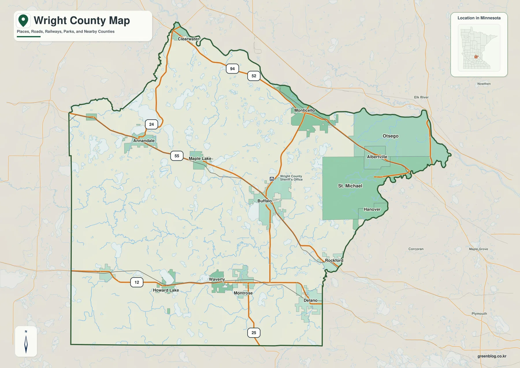
The county boundary is also shaped by water and neighboring urban areas. The northern edge bends with the Mississippi River, and the northeastern Otsego side has a long irregular outline. Around St. Michael, Hanover, and Rockford, the southeastern boundary also twists around adjacent communities rather than following a simple rectangle. Western and southern sections are straighter, making the river- and city-influenced east side visually distinct.
Otsego, St. Michael, and Buffalo reveal several separate city centers
The city map highlights six communities with reference values in its CITY INDEX: Otsego 22,245, St. Michael 20,010, Buffalo 16,499, Monticello 14,858, Albertville 8,207, and Delano 6,942. These figures are the values printed on the supplied map and are useful for comparing the highlighted cities. They should not replace current official Census counts when the latest population data is required.
The ranking alone does not explain the county, because the six cities occupy very different settings. Otsego, St. Michael, and Albertville form a closely spaced northeastern group. Monticello lies farther northwest on I-94 beside the Mississippi River. Buffalo is a separate inland center, while Delano sits near the southeastern edge and connects more directly with the western Twin Cities area. Wright County therefore has several urban focal points rather than one dominant central city.
Otsego is ranked first on the supplied city map and also covers a broad area in the northeast. St. Michael and Albertville sit immediately southwest of it, producing the tightest cluster among the six highlighted places. Buffalo is more isolated amid lakes and interior roads, while Monticello has a river-and-interstate setting. Delano provides a southern reference on the U.S. 12 corridor. Seeing those locations together helps explain why travel patterns differ so much from one part of the county to another.
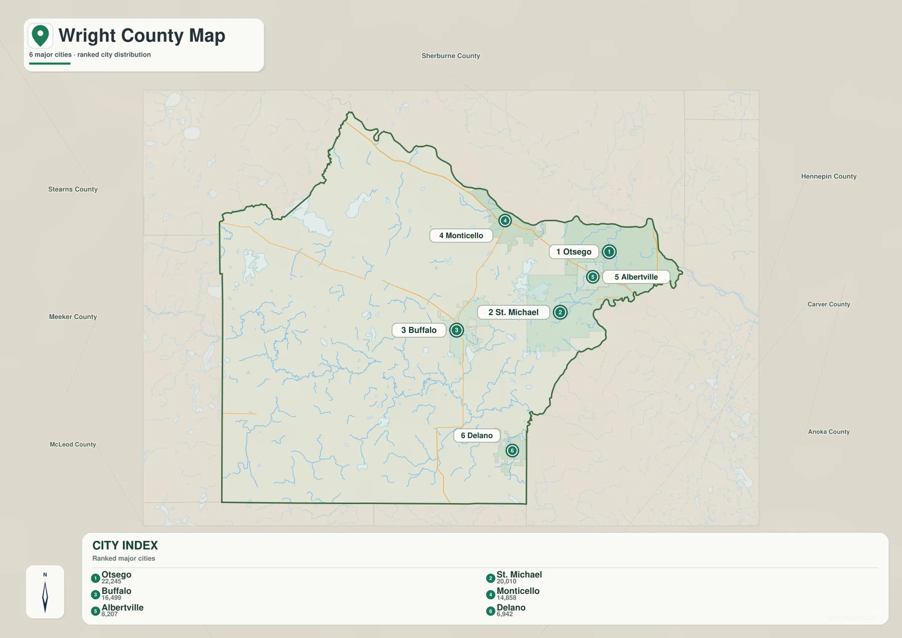
This city map is for relative location and city-size comparison, not driving distance. A straight visual gap between Buffalo and St. Michael, for example, does not represent an actual route. For travel planning, pair the city view with I-94, Minnesota 25, Minnesota 55, and U.S. 12 on the general map or use a current navigation service.
The Mississippi and Crow River systems cross a county filled with lakes
The Mississippi River follows the northern side of Wright County from the Clearwater and Monticello area toward Otsego. It is the largest single water feature on the supplied map and creates a long low corridor along the county edge. In the northwest, the Clearwater River enters the county, and Sugar Lake sits among a broad concentration of lakes. That northern section already shows why Wright County is more water-rich than a simple road map might suggest.
Buffalo Lake is the easiest central lake to identify because it sits beside Buffalo. Nearby, Mill Creek and the North Fork Crow River system cross the interior. North Fork Crow Creek is labeled farther west, and the Annandale–Maple Lake area contains many additional lakes even where individual names are not printed. The western half is therefore characterized less by one dominant river than by a dense mixture of lakes and branching streams.
On the eastern side, the Crow River follows part of the county edge, while the North Fork Crow River and South Fork Crow River occupy different parts of the interior and south. Pelican Lake is a large named lake in the northeastern interior. Elm Creek appears in the southwest, and Dubay Lake is visible beyond the county edge to the east. Together, these features show how the county drains toward both the Mississippi and Crow River systems.
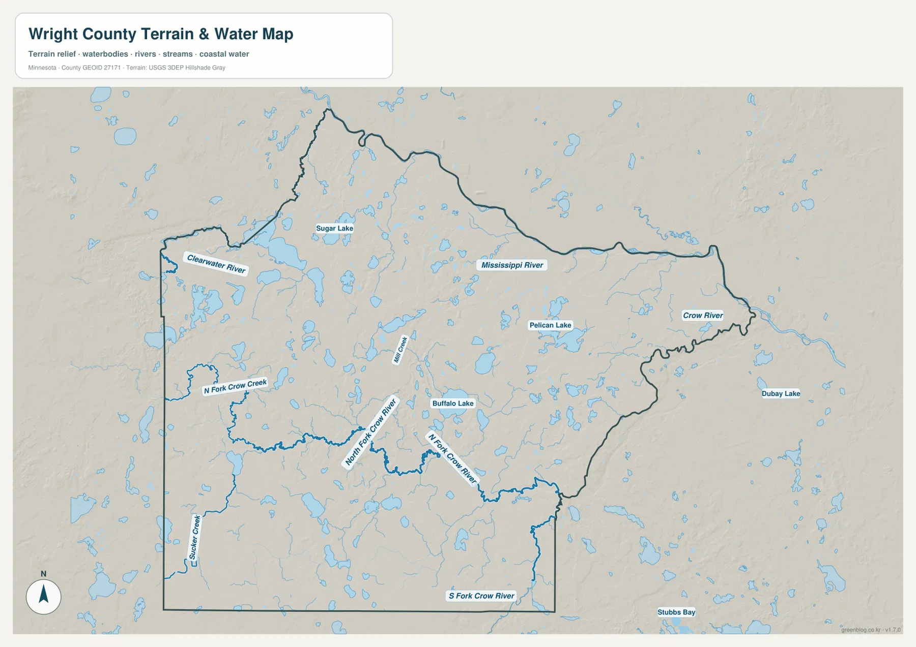
Wright County Parks & Recreation also manages lake-focused sites such as Bertram Chain of Lakes Regional Park, Clearwater/Pleasant Regional Park, Collinwood Regional Park, and Schroeder County Park. Official park information is useful for trails and facilities, while this county-scale water map is better for comparing where rivers and lakes sit relative to the cities. It is not a flood-risk, navigation, water-depth, or water-quality product, so specialized current sources are needed for safety or property decisions.
Elevation rises toward the west and northwest, then falls toward the eastern rivers
The elevation legend reports an actual range of about 259 to 372 meters and a mean near 304 meters. The strongest brown uplands appear in the west and northwest, while broad green lowlands dominate much of the east and southeast. The county is not a simple tilted surface, but the contrast between the higher western lake country and the lower Otsego–St. Michael–Delano side is immediately visible.
Around Annandale and the western lake district, higher ridges appear in several separate blocks. The northwest also includes terrain above 330 meters. Between Maple Lake and Buffalo, elevation changes repeatedly around lakes and small valleys rather than forming one flat plateau. This broken relief helps explain why so many water bodies occupy the western half of the county.
The eastern side around Otsego, St. Michael, Hanover, Rockford, and Delano is generally lower. Low terrain also follows the Mississippi River and Crow River corridors, although small hills remain scattered through the area. With more than 100 meters between the county minimum and maximum, the relief is large enough to create a clear east–west difference even though Wright County has no mountains.
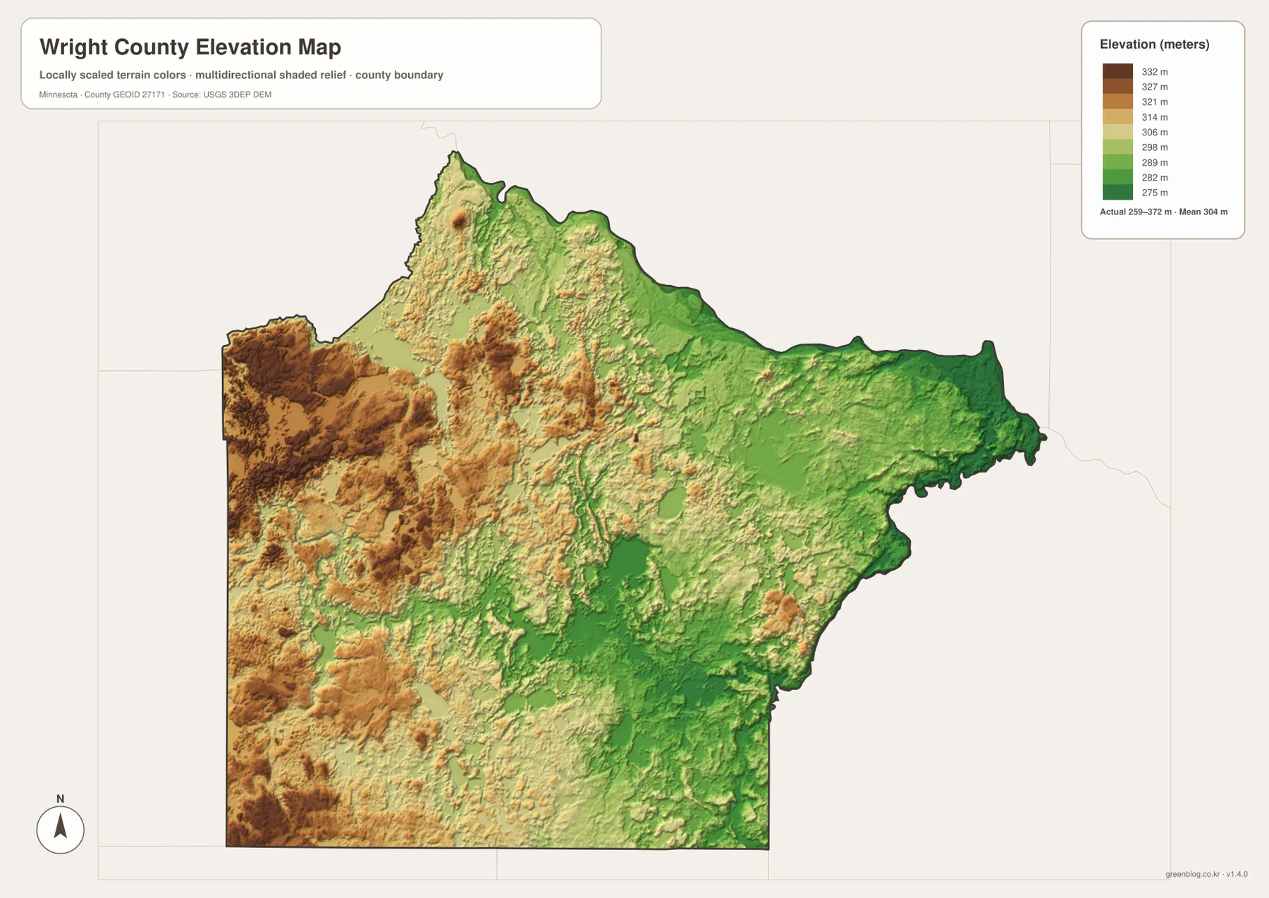
The elevation surface is generalized for county-scale comparison. It should not be used to determine an exact parcel height, road grade, building elevation, drainage design, or engineering measurement. Those uses require source elevation data and field verification. For general map reading, the image is most useful for understanding why the Annandale side appears higher and rougher while the eastern cities occupy broader low ground near major rivers.
A simple way to combine the Wright County maps
Start with Buffalo, then place Monticello to the north, Otsego and St. Michael to the northeast, and Delano to the southeast. Add Annandale and Maple Lake in the west to complete the main settlement pattern. Once those points are fixed, I-94, Minnesota 25, Minnesota 55, and U.S. 12 provide a clear road framework for the county.
Next, switch to the water map and use the Mississippi River and Crow River as the two largest references. Locate Buffalo Lake, Pelican Lake, Sugar Lake, and the North and South Fork Crow River. On the elevation map, those same locations reveal the higher western terrain and lower eastern river corridors. The comparison is especially useful because the county’s urban geography and physical geography change in roughly the same west-to-east direction.
Use the general map when roads, municipal names, and the county boundary matter most. The city map is best for comparing the six highlighted population centers. Choose the water map for rivers and lakes, and the elevation map for the 259–372 meter relief. Keeping those roles separate makes each image easier to use for printing, classwork, presentations, or personal reference.
Frequently Asked Questions
How are Buffalo and the I-94 cities different on the map?
Buffalo is an inland center near Minnesota 25 and Minnesota 55, while the I-94 group follows the northern and northeastern side through Monticello, Albertville, St. Michael, and toward Otsego. The city map makes the northeastern cluster look much tighter, while Buffalo stands apart in the interior.
Which rivers and lakes are the easiest Wright County landmarks?
The Mississippi River along the north and the Crow River system in the east and south are the largest water references. Buffalo Lake, Pelican Lake, and Sugar Lake are also easy to identify, and the North Fork and South Fork Crow River help organize the interior drainage pattern.
Where is Wright County highest and lowest?
The supplied elevation map reports about 259 to 372 meters with a mean near 304 meters. The highest brown terrain is concentrated in the west and northwest, while broad lower green areas appear around the eastern and southeastern cities and along the Mississippi and Crow River corridors.
Map File Information
The ZIP contains the high-resolution JPG originals of the Wright County general map, city map, water map, and elevation map shown on this page.
- Included Files: 4 high-resolution JPG maps
Related Maps
Sources and references
- Wright County Parks & Recreation — official park, trail, and lake-area information
- U.S. Census Bureau TIGER/Line Shapefiles — county boundaries and geographic reference data
- USGS National Hydrography — rivers, streams, and water features
- USGS 3D Elevation Program — elevation and terrain reference data
Green Map creates custom-edited map images using open geographic data sources such as geoBoundaries, Natural Earth, OpenStreetMap, and government open data. These maps are edited visual materials, not raw data files, and are provided for education, documents, presentations, and graphic reference.