Clinton County, Missouri lies north of the Kansas City area and south of St. Joseph, with Plattsburg near the center of a road network that spreads toward Cameron, Lathrop, Gower, Trimble, and smaller communities. Route 116 provides a strong east-west reference through Plattsburg, while I-35 on the eastern side and U.S. 169 on the western side form two major north-south corridors. This article compares settlement, roads, waterways, and relief. The four original high-resolution JPG maps shown here are available together in the download ZIP below.
Plattsburg is the easiest starting point for reading the county. Clinton County’s official website identifies it as the centrally located county seat, and the general map shows Route 116 crossing the city before continuing east toward Lathrop and west toward the U.S. 169 side. Cameron occupies the northeastern edge of the county near I-35, while Gower and Trimble provide useful western and southwestern anchors. That spread of communities gives Clinton County a very different visual pattern from a county dominated by one large urban center.
Water and terrain add another layer to the map. The Little Platte River and Platte River system runs through the middle of the county, Smithville Reservoir reaches into the southwest, and Shoal Creek and Deer Creek drain parts of the east. On the elevation map, those valleys appear as green low corridors between warmer-colored ridges. The mapped elevation range is about 252 to 335 meters with a mean near 301 meters, enough variation to create a dense network of small valleys even though the county does not contain dramatic mountain relief.
Table of Contents
Route 116 through Plattsburg and the county’s two north-south road corridors
On the general county map, Plattsburg sits slightly west of the county’s center and Route 116 runs directly through it. That highway is the clearest east-west guide on the page. Following it west leads toward Gower and the U.S. 169 corridor, while following it east leads to Lathrop and the I-35 side. Because many smaller roads and streams branch away from those routes, locating Route 116 first makes the rest of the map much easier to organize.
Lathrop lies along the eastern half of Route 116, not far from I-35. The official county website describes I-35 as one of the principal north-south routes serving Holt, Lathrop, and Cameron. That relationship is visible on the map: the interstate follows the eastern side of Clinton County, connects the Lathrop area with Cameron to the north, and continues toward Holt to the south. The road does not pass through the county’s geographic center, but it is the strongest regional transportation corridor on the eastern side.
U.S. 169 plays a similar orientation role in the west. Gower sits close to the western boundary, and the same route continues south toward Grayson and Trimble. Route 116 intersects this western corridor before continuing toward Plattsburg, so the combination of U.S. 169 and Route 116 forms an easy L-shaped reference. With I-35 on the opposite side of the county, a reader can quickly place Plattsburg and Lathrop between the two major north-south routes.
Cameron appears at the northeastern edge, where the mapped urban area extends close to the county line. Clinton County’s official introduction notes Cameron’s position at I-35 and Missouri Highway 36, a crossroads that helps explain why the city ranks first on the supplied city-index map. The general county image also shows Route 121 nearby. These roads make the northeastern corner look more connected to long-distance corridors than the interior around Turney, where local roads and stream valleys are more prominent.
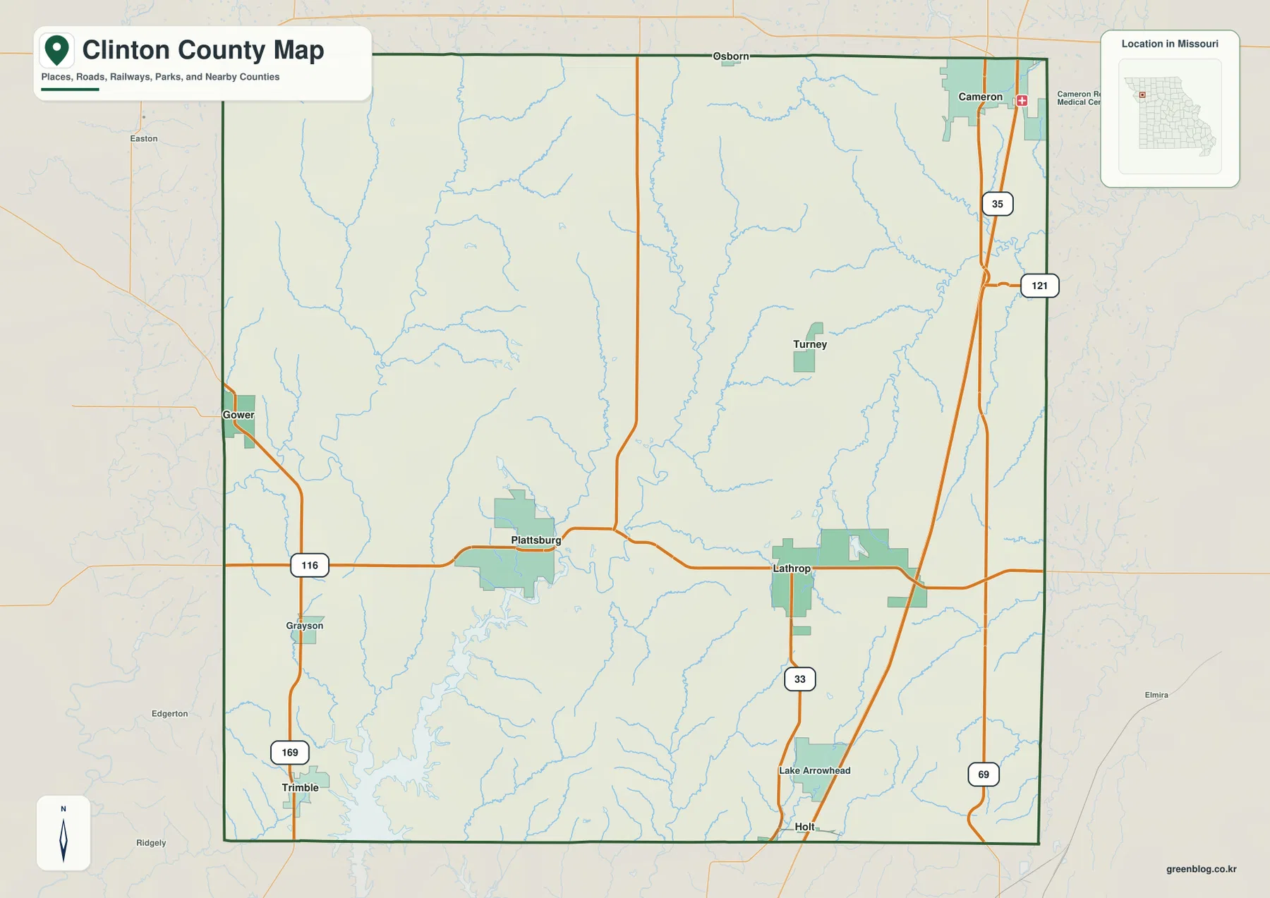
The general map also includes a dense background of creeks and tributaries. South of Plattsburg and around Lathrop, small drainage lines repeatedly cross the road network, and the southwestern corner becomes more complex as the terrain descends toward Smithville Reservoir. For city and route orientation, this map is the best starting point. For named streams and the shape of valleys, the terrain-and-water and elevation maps provide much more detail.
A dispersed city pattern from Cameron to Gower and Trimble
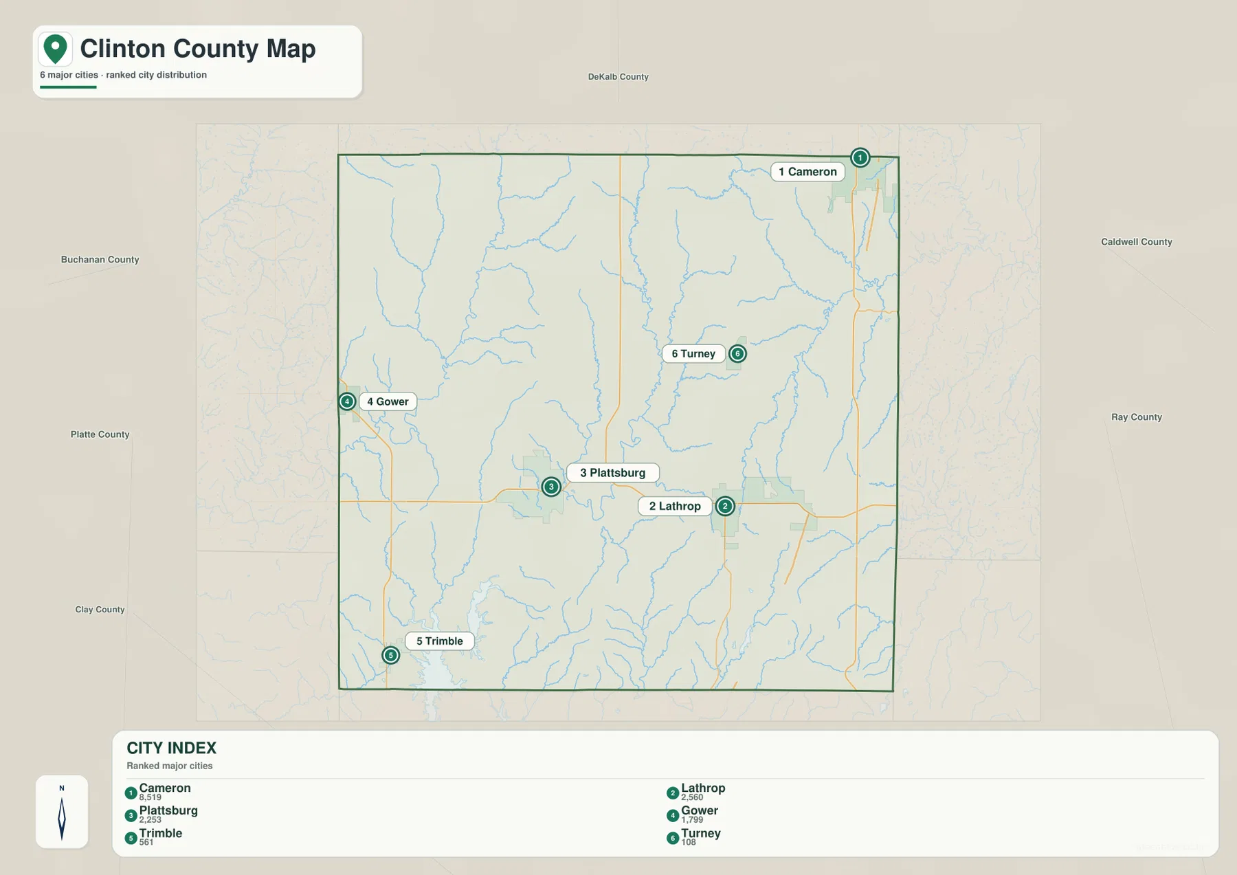
The ranked city map removes most road detail and highlights six major communities. Its order is Cameron first, Lathrop second, Plattsburg third, Gower fourth, Trimble fifth, and Turney sixth. The ranking is a simplified index for comparing major places on the supplied map, not a complete municipal inventory and not a substitute for current population statistics. Its main value is spatial: it shows how widely the county’s principal communities are spread.
Cameron occupies the northeast, while Gower touches the western side and Trimble sits near the southwest. Plattsburg and Lathrop form the closest central pair, both in the southern half of the county’s interior. Turney is farther north and east of them, separated from the biggest road corridors by a landscape of tributaries and rolling uplands. The result is a county without a single continuous urban strip; instead, several towns act as separate reference points along different roads.
The city pattern becomes more meaningful when it is matched to the general road map. Cameron and Lathrop relate closely to the I-35 side, while Gower and Trimble align with U.S. 169. Plattsburg sits between those corridors and connects to both directions through Route 116. Turney is better understood through local roads than through a major highway. This combination explains why a simple city map and a detailed road map answer different questions about the same county.
This is not a connector-distance map. It contains ranks and locations but no straight-line or driving-distance values, so visual spacing should not be read as travel time. A short distance on the page can still involve indirect roads, stream crossings, and changes in relief. For a classroom slide or presentation about settlement distribution, the ranked map is clean and effective. For actual route planning, current navigation data should be used instead.
Pairing the city map with the water map also shows that the communities do not occupy one uniform surface. Plattsburg and Lathrop are surrounded by tributaries of the Platte River system, and the Gower-Trimble side contains numerous small valleys that descend toward Smithville Reservoir. Cameron has its own network of streams in the northeast. The city points become more informative once they are understood as settlements positioned among ridges, drainage lines, and several different road corridors.
Little Platte River, Smithville Reservoir, and the eastern creek valleys
The terrain-and-water map brings the county’s drainage pattern into focus. The Little Platte River descends through the central part of Clinton County and joins the broader Platte River system farther south. Its winding channel occupies a clear low corridor, and numerous short tributaries enter from the surrounding uplands. Compared with the general road map, the water layer makes it much easier to see why the center of the county is divided into a series of narrow ridges rather than one continuous flat surface.
On the western side, Castile Creek forms another long drainage line, joined by smaller branches from the northwest and central uplands. In the southwest, Smithville Reservoir is the largest body of water shown on the map. Its northern reach extends into Clinton County, where branching coves and feeder valleys create a much more irregular landscape than the road map suggests. The reservoir is therefore both a useful landmark and an important clue to the shape of the county’s southwestern terrain.
Eastern Clinton County has a different pattern. Shoal Creek and Deer Creek run roughly southward through the eastern half, with smaller tributaries joining them from either side. Crooked River appears farther southeast, while Lake Lenore and Lake Mc Guinness are marked near the Shoal Creek area. Burlington Lake is labeled in the northeast. These features help separate the eastern drainage network from the central Platte River system.
Near the Platte River, tributaries such as Horse Fork and Grindstone Creek show how water collects from multiple directions before entering the larger channel. The shaded relief surrounding those streams follows the same bends and branching forms, so the map does more than label water. It also shows the physical valleys occupied by the rivers and creeks. That relationship becomes even clearer on the elevation map, where the same corridors appear in the lowest colors.
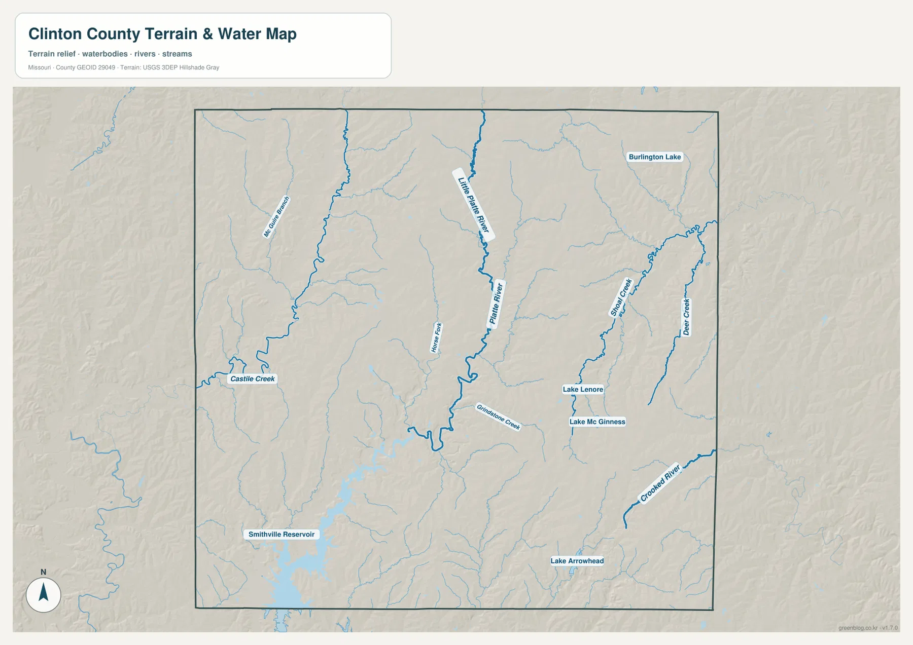
This water-reference map should not be treated as a flood map, legal water boundary, navigation chart, or real-time stream-condition product. It is designed to show the location of rivers, creeks, lakes, and terrain. Questions about flood insurance, current stream stage, property access, boating, or public use require the appropriate current source from USGS, FEMA, local authorities, or the agency managing the specific water body.
252 to 335 meters: rolling ridges cut by a dense network of valleys
The elevation map reports an actual range of roughly 252 to 335 meters and a mean elevation near 301 meters. That is not mountain-scale relief, yet the shaded surface is far from flat. Warm browns and oranges identify relatively higher ground, while greens follow lower stream corridors. The repeated contrast between narrow green valleys and higher ridges creates the finely textured pattern seen across most of Clinton County.
The Little Platte River and Platte River are easy to trace because their valleys form long green bands through the middle of the map. Castile Creek creates another low corridor in the west, and the terrain around Smithville Reservoir opens into broader low areas in the southwest. These features line up closely with the water map, allowing named streams to be matched with their physical valleys.
Higher terrain is especially noticeable across parts of the east and southeast, although it is repeatedly cut by Shoal Creek, Deer Creek, Crooked River, and smaller tributaries. Similar ridge-and-valley textures also occur in the northwest. Clinton County therefore does not simply slope in one direction. Instead, many local watersheds carve their own routes through the uplands, creating frequent rises and drops over relatively short distances.
The colors use a local scale for this county. Green does not identify an official floodplain or wetland, and brown does not indicate a mountain, protected area, or development restriction. The elevation layer is intended for regional comparison. Surveying, construction, drainage design, and other tasks that require precise heights should rely on USGS 3D Elevation Program data or professional measurements rather than estimates taken from the image.
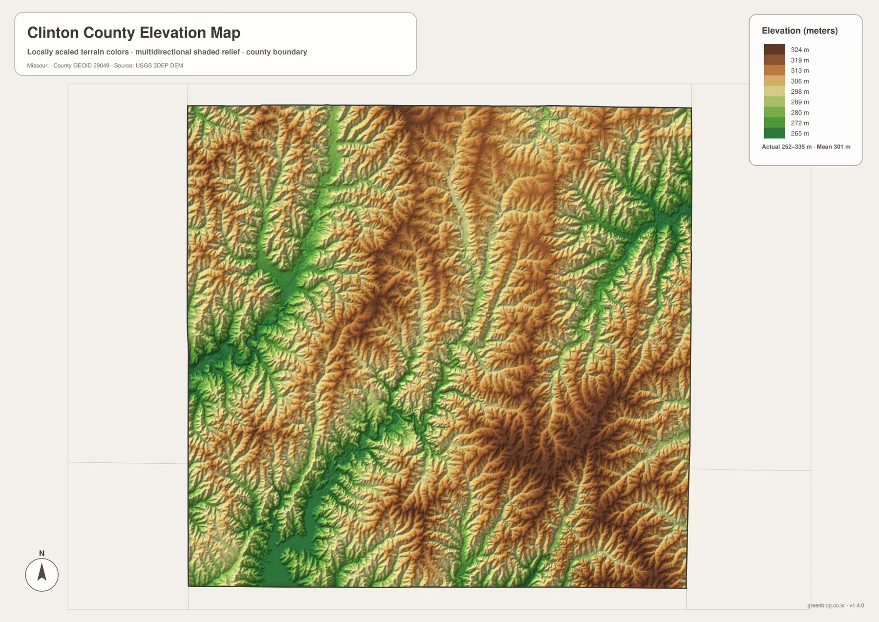
Combining this layer with the road map adds useful context to travel geography. Route 116 crosses several tributaries between Plattsburg and Lathrop, roads around Gower and Trimble pass through valleys draining toward Smithville Reservoir, and even the I-35 side contains repeated small rises and drainage cuts. The total relief is moderate, but the density of valleys helps explain why local roads do not always follow a perfectly regular grid.
Which Clinton County map works best for each question?
Use the general county map first when the goal is orientation. It places Plattsburg, Lathrop, Cameron, Gower, Trimble, Turney, major road numbers, the county outline, and a background network of streams on one page. Route 116, I-35, and U.S. 169 provide simple reference lines, making this the most practical image for locating a community before switching to a more specialized layer.
The ranked city map is better when the settlement pattern needs to be simplified. It emphasizes the six major communities and immediately shows Cameron in the northeast, Gower in the west, Trimble in the southwest, and Plattsburg and Lathrop closer to the center. Because smaller places and most roads are omitted, it works well for presentations but should not be treated as a complete place-name map.
For rivers, creeks, lakes, and valley relationships, choose the terrain-and-water map. The Little Platte River and Platte River provide the central framework, Smithville Reservoir anchors the southwest, and Shoal Creek and Deer Creek reveal a separate eastern drainage pattern. The elevation map is the companion for relief questions, turning those same channels into low green corridors within the county’s 252-to-335-meter range.
A useful sequence is to find Plattsburg on the general map, trace Route 116 toward Lathrop and the I-35 corridor, then switch to the water map and follow the Little Platte River south. Finish with the elevation layer and compare the river valleys with the surrounding ridges. Reading the maps in that order connects transportation, settlement, drainage, and terrain without forcing every type of information onto a single image.
The download archive contains the original high-resolution JPG versions of all four maps. Each file is 3638 by 2572 pixels, providing more room than the embedded WebP previews for enlarging town labels, route shields, stream names, and shaded relief. They are suitable for general reference, classroom work, print layouts, and presentations, but not as substitutes for legal surveys, parcel maps, current navigation, flood-insurance products, or engineering-grade elevation data.
Frequently Asked Questions
What is the easiest way to find Plattsburg on the Clinton County map?
Find Route 116 first. Plattsburg sits slightly west of the county’s center on that east-west highway, with Lathrop farther east and the Gower-U.S. 169 side to the west. Once Plattsburg is located, the rest of the county’s road pattern becomes much easier to organize.
Where is Smithville Reservoir shown in Clinton County?
The terrain-and-water map shows the northern part of Smithville Reservoir in the southwestern portion of the county. Several small valleys and tributaries descend toward it, and the elevation map shows the same area as a broader low corridor. For recreation rules, lake levels, or access information, consult the agency responsible for the reservoir rather than this regional reference map.
Does green on the elevation map mean land is in a floodplain?
No. Green represents relatively lower elevation within the local Clinton County color scale. River valleys such as the Little Platte and Platte stand out in green because they are lower than nearby ridges, but actual flood risk depends on mapped floodplains, rainfall, stream stage, drainage, and other conditions.
Map File Information
The ZIP contains the original high-resolution JPG files for the general county map, ranked city map, terrain-and-water map, and elevation map shown in this article. The originals are larger than the on-page WebP images and make town labels, road numbers, stream names, and terrain detail easier to inspect.
- Included Files: 4 maps
- File Type: JPG
Related Maps
Sources and References
- Clinton County Missouri official website: county-seat information and descriptions of major transportation corridors.
- U.S. Census Bureau QuickFacts – Clinton County, Missouri: official county statistics and geographic information.
- U.S. Census Bureau TIGER/Line Shapefiles: official boundary and transportation geography.
- USGS National Hydrography: official river, stream, lake, and hydrography data.
- USGS 3D Elevation Program: official elevation and terrain-surface data.
Green Map creates custom-edited map images using open geographic data sources such as geoBoundaries, Natural Earth, OpenStreetMap, and government open data. These maps are edited visual materials, not raw data files, and are provided for education, documents, presentations, and graphic reference.