Shiawassee County lies in the central part of Michigan’s Lower Peninsula, where Owosso and Corunna form the most prominent urban cluster and several smaller cities are linked by state highways, rail lines, and river valleys. M-21 crosses the county through Owosso and Corunna, M-52 runs south toward Perry, M-71 angles toward Durand, and I-69 passes across the southern portion. Those routes give the county map a clear structure before the rivers, lakes, and terrain are added. High-resolution map files are available for download in the section below.
This page brings together a general county map, a ranked city index, a water map, and an elevation map. High-resolution A3 JPG originals can be downloaded in one ZIP for printing, classroom use, trip planning, or side-by-side geographic comparison. The maps are designed for broad reference, so specialized decisions involving parcels, engineering, flood regulation, or current road conditions should rely on the appropriate official source.
Table of Contents
Owosso, Corunna, and the main road network
Owosso is the largest and most visually dominant city on the county map, with Corunna immediately to its east. Shiawassee County’s official website also identifies Owosso as the county’s largest city and Corunna as the county seat. M-21 passes through this north-central area, while M-52 runs through Owosso and continues south toward Perry. Together, those roads make Owosso a useful starting point for understanding the county’s overall layout.
Durand stands out in the southeast where M-71 and multiple rail lines converge. I-69 crosses the southern part of the county near Perry, providing a major east–west interstate connection separate from the M-21 corridor farther north. M-13 follows the eastern side, while labels such as Ovid, Henderson, and New Lothrop provide context near or beyond the county edges.
Railroads are unusually noticeable on this map, especially around Owosso and Durand. Their presence helps explain why those places appear as transportation nodes rather than isolated towns. The map does not indicate current schedules, service frequency, or operational status, but it does make the broad relationship among communities, highways, and rail corridors easy to see.
Six ranked cities across the county
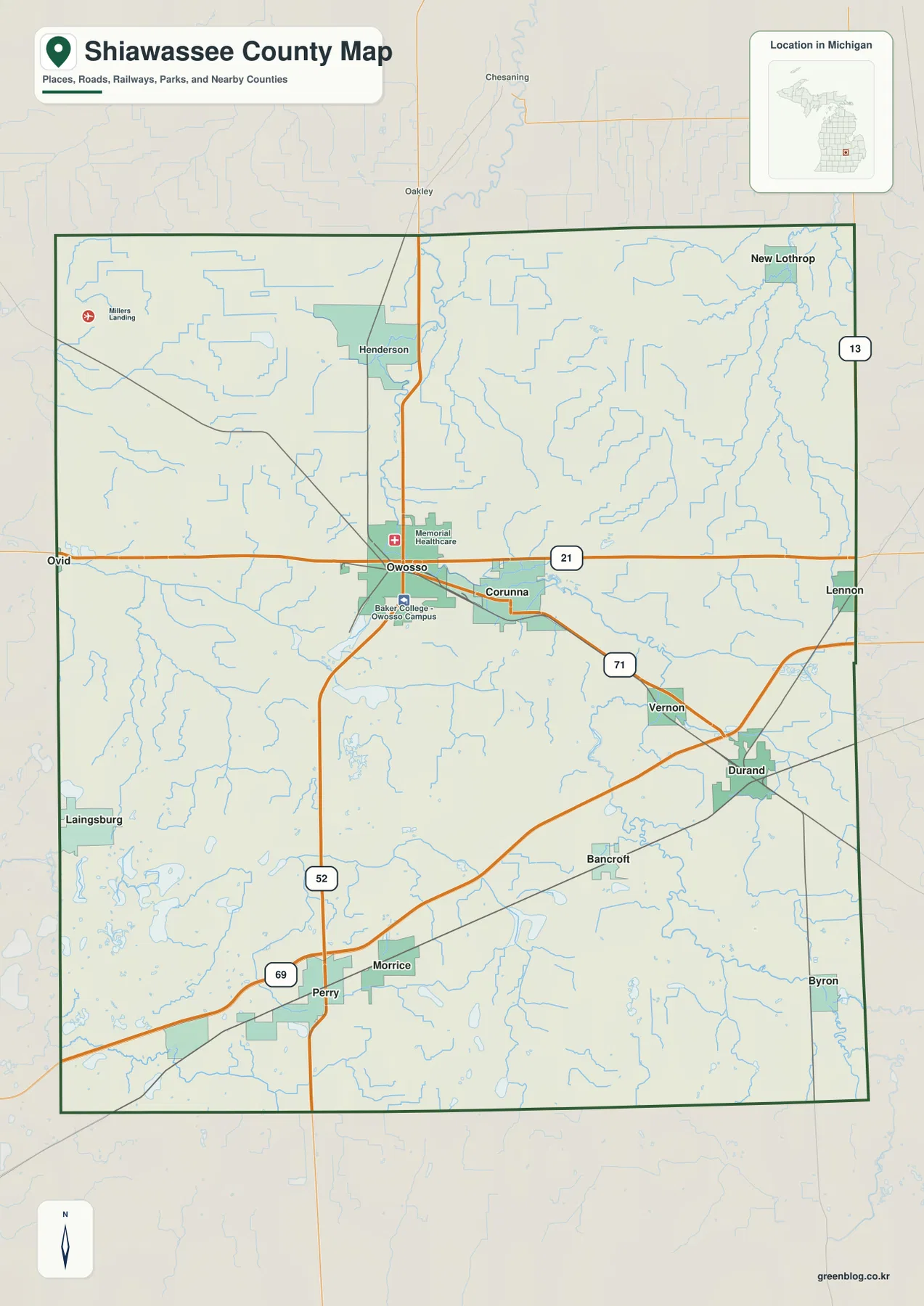
The city index ranks six selected cities. Owosso is number 1 with a printed value of 14,632, followed by Durand at 3,483, Corunna at 3,037, Perry at 2,073, Laingsburg at 1,769, and Morrice at 1,550. These figures are reproduced from the supplied city-index graphic rather than substituted with a new population estimate, so they should be treated as the values used by this particular map.
The positions reveal a dispersed settlement pattern rather than one continuous urban area. Owosso and Corunna sit close together in the north-central part of the county, Durand is southeast of them, Perry and Morrice are farther south, and Laingsburg lies near the western side. The greatest concentration of roads and rail lines appears around Owosso–Corunna and Durand.
There are no distance connectors or mileage labels on the city index. It is not a straight-line distance chart and should not be used to estimate driving mileage. For route planning, compare the city positions with the general county map and then use a current navigation source for actual road distance and travel time.
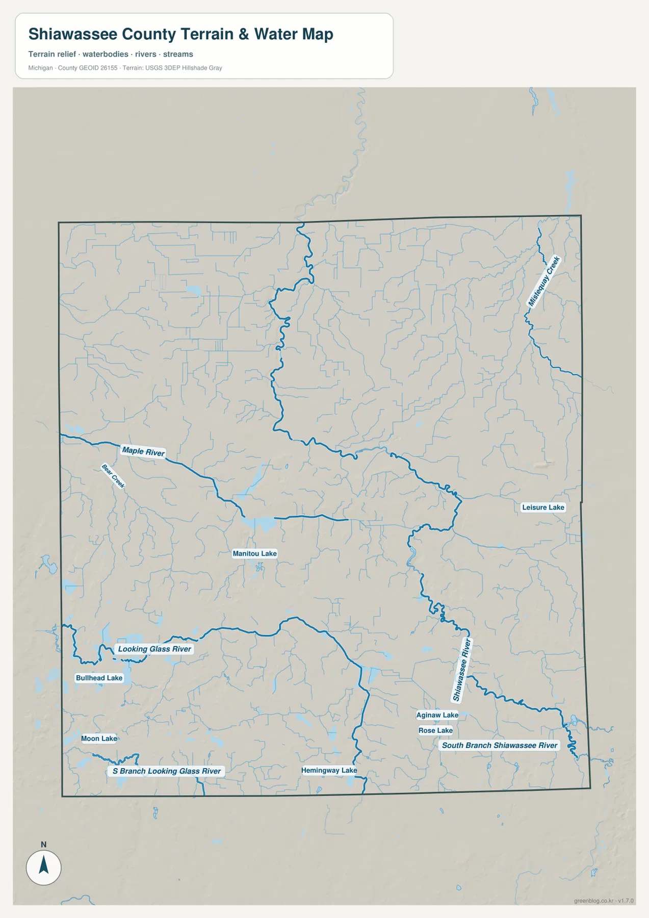
The Shiawassee River and the county’s other waterways
The Shiawassee River is the defining waterway on the map. Shiawassee County’s official description says the river enters near the southeast corner, passes through Byron and Vernon, then continues through Corunna and Owosso before flowing north toward the Saginaw Bay system. The water map shows the same broad path, with a strong river corridor running from the southeastern area through the central cities and toward the northern boundary.
The Maple River crosses the western and central part of the county, while the Looking Glass River and South Branch Looking Glass River occupy the southern side. Those rivers add separate drainage corridors away from the main Shiawassee channel. Misery Creek is labeled on the eastern side, and many smaller tributaries branch across the northern and eastern portions of the county.
Several named lakes help break up the dense stream network. Manitou Lake appears west of center, Leisure Lake lies farther east, and Aginaw Lake and Rose Lake sit near the southeastern Shiawassee River corridor. Hemingway Lake is shown in the south, while Bullhead Lake and Moon Lake appear toward the southwest. Their distribution shows that the county’s water geography includes both river valleys and scattered small lakes.
The river also has a direct connection to local recreation. Shiawassee County Parks notes that several county parks are located along the Shiawassee River, with opportunities such as hiking, fishing, and canoe access. The water map is not a park-facility guide, but it helps place those river-oriented recreation areas in the larger county landscape.
Use the water map for names and relative locations rather than flood risk, navigable depth, legal shoreline boundaries, or property ownership. Those questions require current agency products developed for that specific purpose.
A 194–294 meter elevation range
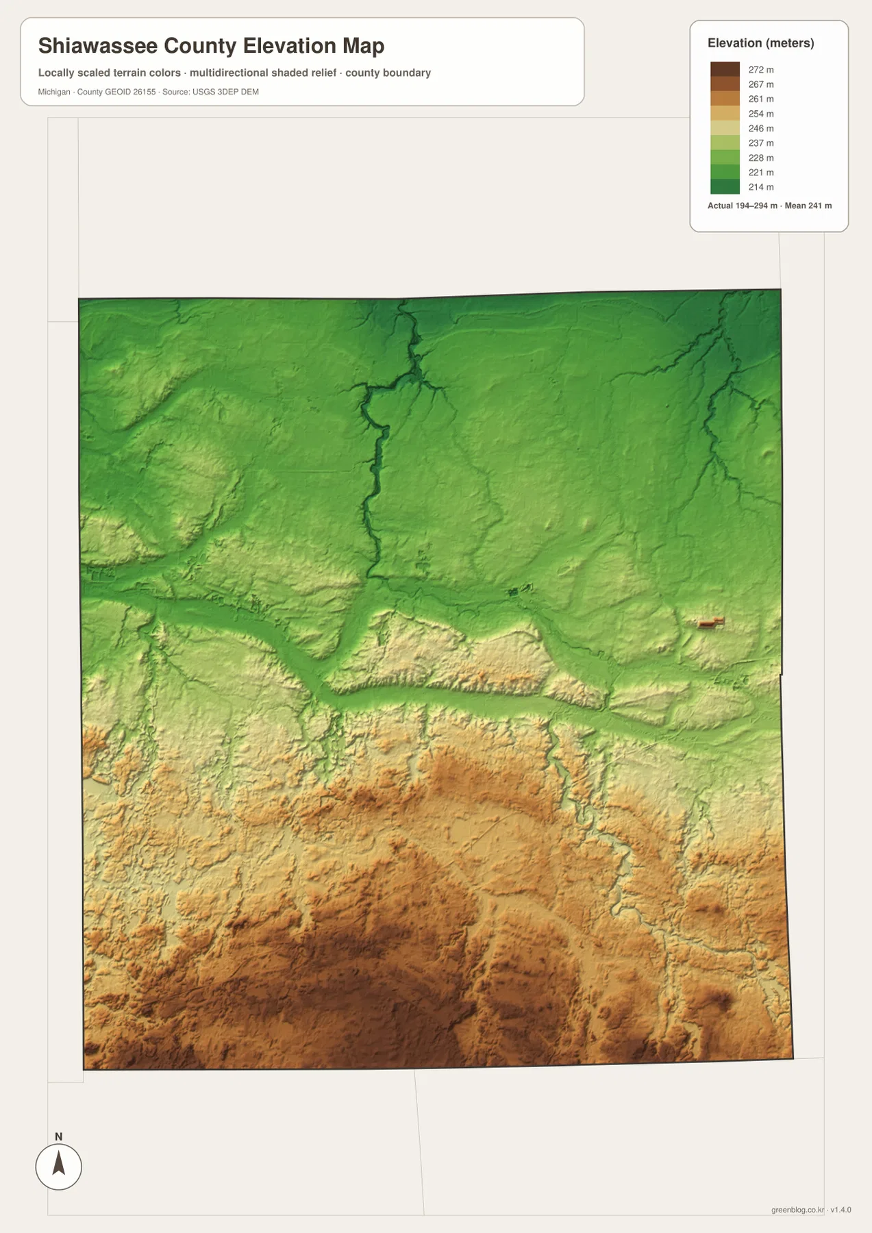
The elevation map reports an actual range of about 194 to 294 meters and a mean near 241 meters. Greens represent lower ground, while tan and brown colors mark higher terrain. The northern part of the county and several major river corridors are broadly lower, while higher colors become more common across the south and southwest.
The Shiawassee River valley is especially easy to recognize because a darker green corridor follows the river northward through lower terrain. Other streams also occupy shallow low areas cut into the surrounding land. South of the central river belt, the shaded relief becomes stronger and the colors shift toward tan and brown, showing a clear rise toward the southern half of the county.
Owosso and Corunna sit close to the lower river corridor, while the Perry area is surrounded by more elevated terrain. That difference is useful when comparing the road map with the elevation layer because it shows how settlements and transportation routes cross both river lowlands and higher ground. The county is not mountainous, but it is also not uniformly flat.
This elevation surface is intended for county-scale comparison. It is not survey-grade data for a building site, drainage project, road design, or other work where small elevation differences matter. Detailed USGS elevation products and field measurements should be used for precise site decisions.
What becomes clearer when the maps are compared
The maps work especially well when one place is followed across multiple layers. Start with Owosso and Corunna on M-21, then move to the water map and the Shiawassee River becomes the dominant feature passing through the same area. On the elevation layer, that river corridor is lower than much of the southern county, adding a terrain explanation to what first looks like a simple city-and-road cluster.
Durand offers a different comparison. The general map emphasizes its rail and road connections, while the water layer shows the Shiawassee River system approaching from the south and southeast. Perry and Morrice, by contrast, sit closer to the I-69 corridor and the higher southern terrain. These differences help distinguish the county’s urban nodes without relying only on population rank.
The set is useful for school assignments, local-history presentations, trip preparation, and general county orientation. It does not replace parcel maps, legal surveys, zoning documents, flood-regulation products, or real-time transportation information. Use county, state, and federal sources when a decision requires current legal or technical accuracy.
Download the A3 JPG map files
The ZIP below contains the high-resolution A3 JPG originals for the general county map, ranked city index, water map, and elevation map described on this page. You can print one map, keep the full set for reference, or compare two files side by side when studying roads, rivers, settlements, and terrain.
Frequently Asked Questions
Which map is best for comparing Owosso and Durand?
Use the city index for their relative positions and rank, then check the general county map for the road and rail connections. Owosso is in the north-central area, while Durand is southeast of it near M-71 and several rail lines.
Are the city-index numbers current population estimates?
The values on this page are copied from the supplied city-index graphic. For the latest population figures, use current U.S. Census Bureau or local-government statistics rather than assuming the map values are current estimates.
Can the 194–294 meter elevation range be used for engineering work?
No. The elevation map is suitable for broad comparison of higher and lower terrain, but precise design, drainage, construction, or survey work requires more detailed official elevation data and field verification.
Map File Information
A ZIP containing the high-resolution A3 JPG originals for the Shiawassee County map, city index, water map, and elevation map.
- Included Files: county map, city index map, water map, elevation map
- File Type: JPG
Related Maps
Sources and references
- U.S. Census Bureau TIGER/Line Shapefiles – official geographic files used for county boundaries, roads, and place references.
- USGS National Hydrography – federal source for rivers, streams, lakes, and other hydrographic features.
- USGS 3D Elevation Program – official U.S. elevation and terrain data resources.
- Shiawassee County official website – county information about Owosso, Corunna, the Shiawassee River, and local government.
- Shiawassee County Parks – official information about parks and recreation along the Shiawassee River.
Green Map creates custom-edited map images using open geographic data sources such as geoBoundaries, Natural Earth, OpenStreetMap, and government open data. These maps are edited visual materials, not raw data files, and are provided for education, documents, presentations, and graphic reference.