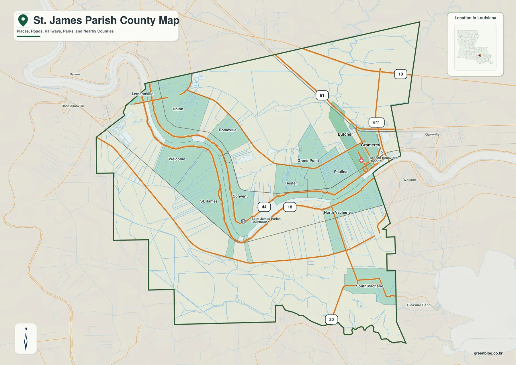
St. James Parish in southeastern Louisiana is shaped first and foremost by the Mississippi River. The river makes a broad series of bends through the middle of the parish, separating Convent, St. James, Welcome, Paulina, Lutcher, Gramercy, and the Vacherie communities into distinct riverbank sections. U.S. 61 provides the clearest highway reference in the east and north, while LA 44 and LA 18 are more useful along the river corridor. This page explains those visible settlement, road, and water relationships, and the matching high-resolution JPG map files can be downloaded together in a ZIP.
Convent is the parish seat, while Lutcher and Gramercy are the two towns highlighted most strongly on the city-index map. The official parish history explains that St. James developed on both banks of the Mississippi and that the seat of government moved from the west-bank St. James area to the Convent area in 1869. That history fits the map: the parish is not organized around one large urban center, but around a river corridor with several communities positioned along different bends and road segments.
Table of Contents
The Mississippi River bends divide Convent and St. James into different riverbank sections
The general parish map shows the Mississippi River entering from the northwest, curving around the Convent and St. James area, and then continuing toward the Lutcher–Gramercy side. The broad bends are large enough that they become more important for orientation than a simple east-west grid. Convent sits close to the river in the central part of the parish, while St. James and Welcome occupy the western side of the same larger bend.
Lemannville and Union appear near the northwestern river section, and Romeville is positioned farther east of them. Paulina, Grand Point, and Hester occupy the central-eastern area. Because these communities follow the river and nearby roads rather than a rectangular street pattern, using the shape of the Mississippi itself is the fastest way to understand where they sit relative to one another.
Lutcher and Gramercy form the clearest town cluster near U.S. 61
The eastern side contains the most obvious concentration of developed streets. Lutcher and Gramercy sit very close together, with U.S. 61 passing to the north and LA 641 providing a north-south road reference. LA 10 appears near the northeastern boundary, while Garyville and Wallace are visible beyond the parish edge in neighboring St. John the Baptist Parish. This cluster makes the Lutcher–Gramercy area the easiest eastern anchor on the map.
West of those towns, Grand Point and Paulina extend the settlement pattern toward the center, while Hester lies close to the Mississippi River. North Vacherie and South Vacherie occupy the southern river side and connect toward LA 20. U.S. 61 is the stronger regional highway reference, but LA 44 and LA 18 are more useful when following the riverbank communities and the Convent area.
Convent is easier to find by the courthouse and river roads than by urban density
Convent is labeled beside the St. James Parish Courthouse near LA 44 and LA 18. Unlike Lutcher and Gramercy, it is not shown as a dense urban block, so the courthouse and road pattern are more useful landmarks than a large street grid. The official parish history notes that the government seat was moved to this area in the nineteenth century and remains here today.
West of Convent, St. James and Welcome continue along the river, while Union and Romeville appear across or beyond the large bend to the north. This makes Convent a useful administrative reference in the middle of a river-oriented settlement chain rather than the center of a conventional metropolitan area. The general map communicates that distinction much better than a simple city list.
The city index ranks Lutcher and Gramercy without treating the numbers as distance
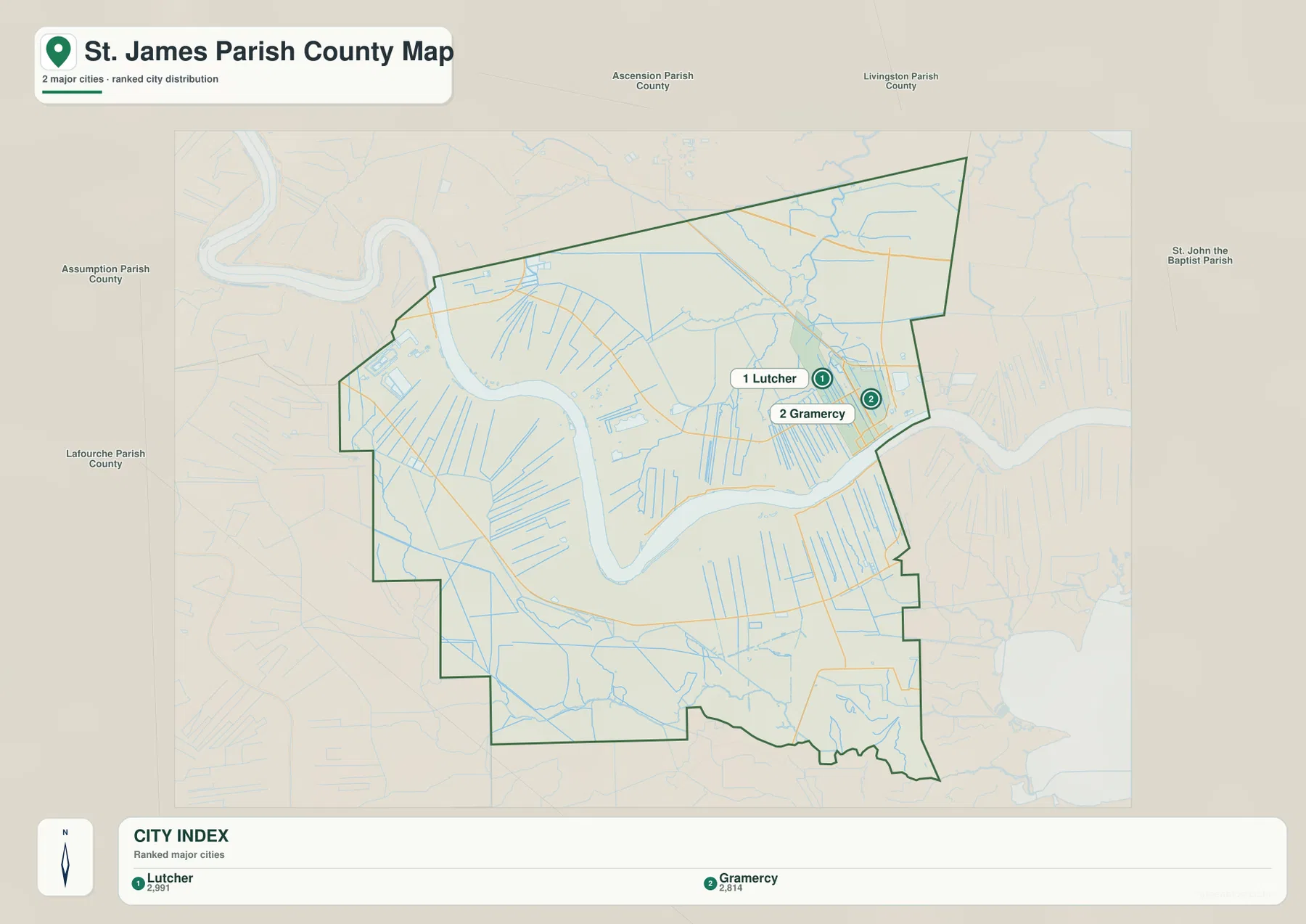
The city-index graphic contains only two ranked towns: Lutcher is number 1 and Gramercy is number 2. Those numbers are rankings, not straight-line or driving distances. The two places are located very close to one another on the eastern side of the parish, which makes the index more about their relative prominence and location than about separation.
Convent, St. James, Welcome, Paulina, and the Vacherie communities remain important on the general map even though they do not appear in this two-place ranking. The city index should therefore be used as a simplified comparison of Lutcher and Gramercy, while the general map is the better choice for the full river-road settlement pattern.
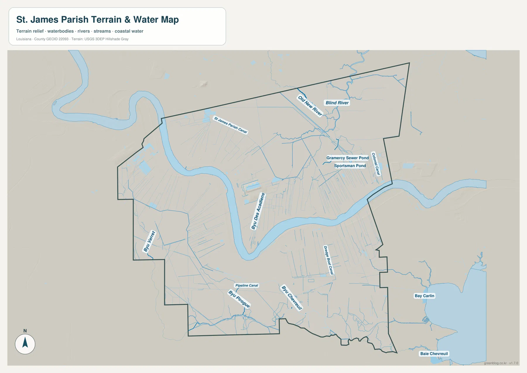
Blind River and Old New River reveal a different water network in the northeast
The terrain-and-water map changes the focus from settlements to a complex drainage system. Blind River and Old New River are the strongest named channels in the northeast, surrounded by many smaller tributaries and drainage lines. St. James Parish Canal also reaches across the northern interior, linking this low-lying section to other channels away from the Mississippi main stem.
Near Gramercy, the map labels Gramercy Sewer Pond and Sportsman Pond, while Golden Canal runs down the eastern side. These names represent a mix of natural and engineered water features rather than one uniform category. That distinction matters because the water map is useful for location and pattern, not for assuming that every blue line or pond has the same origin or purpose.
Bayou Verret and Bayou Chevreuil fill the lower parish with natural and engineered channels
The southern and southwestern sections contain Bayou Verret, Bayou Chevreuil, and Bayou Pierroguet, along with Pipeline Canal and Drainage Canal. These features show that the broad area south of the Mississippi River is not empty land; it is divided by a dense mixture of bayous, drainage channels, and small waterways.
Bay Carlin and Baie Chevreuil appear beyond the southeastern edge and provide wider wetland context. The map is intended for general geographic reference only. It does not provide flood-zone classifications, water depth, navigability, levee-protection status, or legal property boundaries, so those decisions require current specialized information from the responsible agencies.
Reading the river bend first makes the road and water maps easier to combine
A practical first step is to locate the large Mississippi River bend and then place Convent near the center of the parish. From there, St. James and Welcome extend west, while Lutcher and Gramercy create the main eastern town cluster. U.S. 61 is useful for the upper-eastern road pattern, while LA 44 and LA 18 help with the riverbank communities and courthouse area.
For water features, separate the Mississippi main stem from the Blind River system in the northeast and the Bayou Verret–Bayou Chevreuil network in the south. The general map is best for communities and roads, the city index for Lutcher and Gramercy, and the terrain-and-water map for bayous, canals, and the wetland drainage pattern. Enlarging the original JPG is especially helpful when the smaller channel names become difficult to read on screen.
Original JPG files make small river-road and canal labels easier to inspect
The downloadable ZIP contains the original JPG files corresponding to the three previews on this page: the general parish map, the ranked city map, and the terrain-and-water map. Each original image is 3638 by 2572 pixels, providing more room to inspect route numbers, community names, bayou labels, and canal names than the web preview. The files are useful for printing, classroom material, presentation slides, and personal geographic reference.
Choose the general map when Convent, Lutcher, Gramercy, the river corridor, and major roads need to appear together. Use the city index for a quick comparison of Lutcher and Gramercy. The water map is the better choice for the Mississippi River, Blind River, Bayou Verret, Bayou Chevreuil, and the canal network. These are general reference maps rather than legal boundary, survey, flood-risk, or real-time navigation products.
Frequently Asked Questions
What is the parish seat of St. James Parish?
Convent is the parish seat. The official parish history says the seat of government moved from the west-bank St. James area to the Convent area in 1869. On the supplied map, Convent is easiest to locate near the parish courthouse and the LA 44–LA 18 road corridor.
Do the numbers 1 and 2 on the city map represent distance between Lutcher and Gramercy?
No. They are rankings for Lutcher and Gramercy, not straight-line or driving distances. The two towns are close together in the eastern parish, but actual travel distance and time should be checked with the general road map and current navigation information.
Can the Blind River and canal map be used for flood or navigation decisions?
No. It is a general geographic reference showing the Mississippi River, Blind River, Old New River, bayous, ponds, and canals. It does not provide flood-zone ratings, water depth, navigability, levee protection, or legal property boundaries. Those decisions require current specialized information.
Map File Information
The ZIP contains the original high-resolution JPG files corresponding to the general parish map, ranked city map, and terrain-and-water map shown on this page.
- Included Files: parish map JPG, ranked city map JPG, terrain-and-water map JPG
Related Maps
Sources and references
For parish-seat and municipality information, see the Louisiana.gov St. James Parish Profile. Local history and the move of the government seat are documented on the official St. James Parish history page. General boundary data are documented by the U.S. Census Bureau TIGER/Line Shapefiles, and national water-feature data are documented through USGS National Hydrography.
Green Map creates custom-edited map images using open geographic data sources such as geoBoundaries, Natural Earth, OpenStreetMap, and government open data. These maps are edited visual materials, not raw data files, and are provided for education, documents, presentations, and graphic reference.