Grant Parish sits in north-central Louisiana, with Colfax serving as the parish seat and a group of small towns and villages spread well beyond a single urban center. Dry Prong and Pollock form useful central-southern reference points between the U.S. 167 and U.S. 165 corridors, Montgomery lies to the west, Georgetown is near the northeastern side, and Creola appears near the southern boundary. The maps on this page separate roads and settlements from the water network so the parish is easier to understand, and the corresponding original high-resolution JPG files can be downloaded together from the file box later in the article. High-resolution map files are available for download in the section below.
Colfax is a useful starting point because the State of Louisiana’s official Grant Parish profile identifies it as the parish seat and lists Colfax, Montgomery, and Pollock as towns, with Creola, Dry Prong, and Georgetown as villages. On the base map, Colfax is close to the southwestern side of the parish near U.S. 71 and several connecting roads. U.S. 167 runs through the central-southern part of the parish near Dry Prong and Pollock, giving readers another clear line for orienting themselves.
Table of Contents
Finding Colfax, Dry Prong, and Pollock on the Road Map
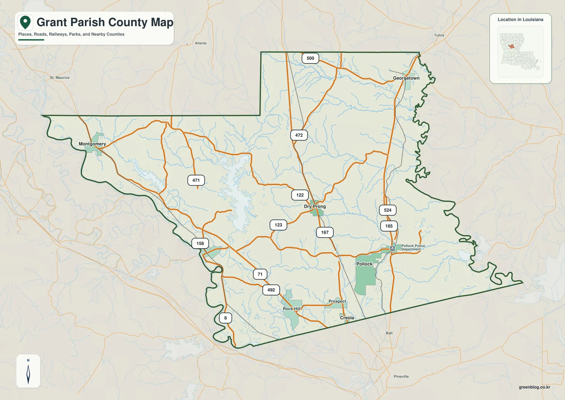
The base parish map combines the boundary, named communities, numbered highways, rail lines, and many streams in one view. Colfax appears close to the southwestern edge, while Dry Prong is farther northeast near a cluster of state routes. Pollock lies southeast of Dry Prong and is connected to the broader road network by U.S. 167 and U.S. 165. Because these places sit in different parts of the map rather than in one compact cluster, the road network is a practical way to understand how the parish is organized.
Several route numbers help separate one part of Grant Parish from another. LA 122, LA 123, LA 471, and LA 472 are visible around the central area near Dry Prong. U.S. 165 runs toward Pollock and continues northward toward Georgetown, while U.S. 71 and LA 8 are useful references near Colfax and the southwestern side. The map is meant for general geographic orientation; it should not be treated as a source for live traffic, road closures, or turn-by-turn navigation.
A Parish of Widely Spaced Communities
Grant Parish does not have one dense band of settlements. Montgomery occupies the western side near the long projection of the parish boundary, Georgetown is far to the northeast, and Colfax sits much closer to the southwestern side. Dry Prong falls between these outer communities, while Pollock and Creola are farther south. That distribution gives the parish a broad east-west spread as well as a clear north-south dimension.
The outline itself reinforces that impression. The western side extends outward toward Montgomery, the northeastern edge becomes irregular near Georgetown, and the southeastern boundary angles for a long distance before reaching the more winding eastern side. Looking at the boundary together with the road network makes it easier to understand why trips between places such as Montgomery, Georgetown, and Pollock do not follow one simple central corridor.
Six Major Places on the City Distribution Map
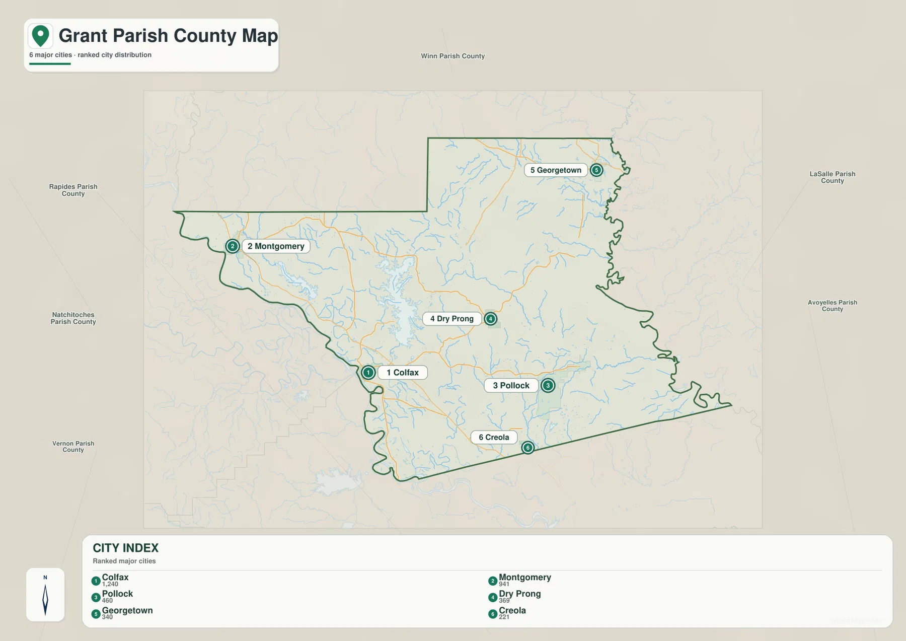
The city distribution map removes much of the road detail and emphasizes six labeled places: Colfax, Montgomery, Pollock, Dry Prong, Georgetown, and Creola. Its CITY INDEX ranks Colfax first, Montgomery second, Pollock third, Dry Prong fourth, Georgetown fifth, and Creola sixth, with a numerical reference shown for each. Those figures are useful as part of this map’s city index, but readers who need current population totals should verify them with current U.S. Census Bureau data rather than treating the map labels as a live statistical table.
The simplified view makes the geographic spread especially clear. Colfax is in the southwest, Montgomery is far to the west-northwest, Georgetown is isolated toward the northeast, and Pollock and Creola sit in the southern half. Dry Prong occupies a more central position between those points. Around the outside, the map labels surrounding parishes including Winn, LaSalle, Avoyelles, Rapides, Natchitoches, and Vernon, which helps place Grant Parish within the broader central Louisiana region without implying that every labeled parish shares a direct boundary.
The Red River Along the Southwestern Side
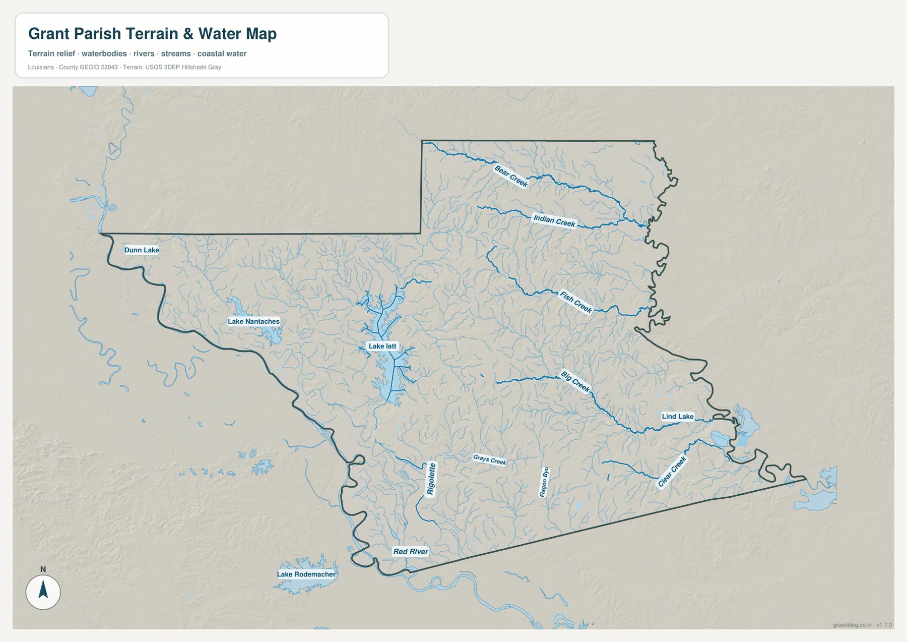
The terrain-and-water map shifts attention away from highways and immediately makes the Red River one of the strongest landmarks. The river bends near the southern and southwestern side of Grant Parish, close to the part of the boundary where Colfax appears on the base map. Smaller channels and winding water features also become more visible, giving this side of the parish a very different appearance from the road-focused map.
The Red River is useful as a large-scale geographic reference, but this map is not a flood map, navigation chart, or legal boundary document. A river shown near the edge of the parish does not by itself indicate current flood risk, navigability, depth, or property limits. Those questions require current official sources prepared for the specific purpose. Here, the river is best used to understand the parish’s southwestern setting and the relationship between the larger waterway and the smaller interior drainage network.
Bear Creek and Indian Creek in the Northeast
Two named streams stand out in the northeastern part of the water map: Bear Creek and Indian Creek. Both run generally eastward across the northern half and are joined by numerous smaller branches. Georgetown lies near this broader northeastern section on the base map, so comparing the two views shows how a place that is road-oriented on one map sits within a much denser network of creeks on the other.
Farther south, Fish Creek is another prominent named channel, followed by Big Creek and Clear Creek in the eastern and southeastern sections. The many unnamed tributaries surrounding them matter visually even when they are not labeled. Rather than a landscape defined by only one or two streams, the eastern half of Grant Parish appears heavily dissected by small waterways, which is why the terrain-and-water map is especially useful for natural-feature questions.
Lake Nantachies, Lake Iatt, and the Western Lakes
The western half of the parish contains several named lakes that are easy to miss on a road-first view. Dunn Lake appears near the northwestern side, Lake Nantachies lies farther south, and Lake Iatt is a larger, more intricate water feature to the east of Lake Nantachies. The concentration of streams around Lake Iatt makes that area one of the busiest sections of the water map.
These lakes can serve as landmarks for regional orientation, but the map does not provide boat launches, ownership, depth, fishing rules, or current water levels. Anyone planning recreation should use current local or state information for those details. On this page, the lakes are presented as geographic features that help distinguish the western and central-western parts of Grant Parish from the creek-dominated northeast.
Big Creek, Clear Creek, and the Southeastern Drainages
Big Creek crosses a long section of the eastern half before approaching the area around Lind Lake near the parish edge. Clear Creek lies farther south and is also joined by a fine network of smaller tributaries. This part of the parish is useful for comparing the city map with the water map: Pollock and Creola look simple as point locations on the city view, while the water view shows how many small channels occupy the surrounding landscape.
Grays Creek is also labeled in the southern interior, and the map contains additional small waterways between the central and Red River sides. A simple way to read the full water map is to divide it into a few anchors: the Red River in the southwest, Bear Creek and Indian Creek in the northeast, Lake Iatt and Lake Nantachies in the west, and Big Creek with Clear Creek in the east and southeast. That method avoids getting lost among the many minor tributaries.
Reading the Shaded Terrain Without Treating It as Survey Data
The terrain-and-water map includes subtle shaded relief behind the rivers, lakes, and streams. This shading gives a broad visual impression of surface variation across the parish and helps the drainage network stand out, but it is not designed to provide an exact elevation at a specific road, house, or parcel. The overall surface appears gently varied rather than mountainous, with the branching creeks and the Red River corridor providing stronger visual cues than steep relief.
Precise elevation work should rely on dedicated data such as the U.S. Geological Survey 3D Elevation Program, while official hydrography sources are more appropriate when exact water-feature data is required. Construction, engineering, flood determination, and property research all need specialized datasets. The map here is intentionally a general-reference product for people who want to understand the parish’s broad terrain and waterways without working through a technical GIS interface.
Choosing the Map That Matches the Question
For an overall introduction, the base parish map is the strongest single choice because it combines named communities, numbered roads, boundaries, railways, and general hydrography. It works well when a reader needs to locate Colfax, Dry Prong, Pollock, Montgomery, and Georgetown while still keeping the road network visible. The city distribution map is better when the goal is to compare the six principal labeled communities without most of the roadway detail.
The terrain-and-water map becomes the better choice when the subject is the Red River, Bear Creek, Indian Creek, Big Creek, Clear Creek, Lake Iatt, or Lake Nantachies. It reduces the visual emphasis on transportation and brings the drainage network forward. The three maps therefore complement one another rather than simply repeating the same information in different colors.
The downloadable ZIP contains the original JPG versions corresponding to the maps shown in the article: the base parish map, city distribution map, and terrain-and-water map. Each source image is 3638 × 2572 pixels, giving more room for zooming and printing than the WebP versions used for the page. They are useful for classroom handouts, presentation slides, regional introductions, and personal reference, but legal boundaries, surveying, flood decisions, and engineering work should always use authoritative purpose-built sources.
Frequently Asked Questions
What is the easiest place to use as a starting point on the Grant Parish map?
Colfax is a practical starting point because Louisiana’s official parish profile identifies it as the parish seat, and the base map places it near the southwestern side where U.S. 71 and several roads come together. From Colfax, Dry Prong and Pollock lie generally to the east and southeast, Montgomery is west-northwest, and Georgetown is far to the northeast.
Are the city index numbers on the distribution map current population figures?
They should be treated as values used in the supplied city index rather than as a live population table. The map is useful for comparing the relative placement and ranking of Colfax, Montgomery, Pollock, Dry Prong, Georgetown, and Creola. For current official population estimates or census counts, check the U.S. Census Bureau or the relevant municipal sources.
Which map is best for the Red River, Bear Creek, and Lake Iatt?
Use the terrain-and-water map when waterways are the main subject. It gives much greater emphasis to the Red River, Bear Creek, Indian Creek, Big Creek, Clear Creek, Lake Nantachies, Lake Iatt, Dunn Lake, Lind Lake, and many smaller tributaries. It remains a general geographic reference, however, and should not be used to determine flood risk, water depth, navigation status, or legal property boundaries.
Map File Information
Download the original high-resolution JPG files corresponding to the parish base map, city distribution map, and terrain-and-water map in one ZIP archive.
- Included Files: parish map JPG, city distribution map JPG, terrain-and-water map JPG
Related Maps
Sources and References
- Louisiana.gov – Grant Parish Profile: official state information identifying the parish seat and listing Grant Parish towns and villages.
- Grant Parish Police Jury: the parish government website for local administrative information.
- U.S. Census Bureau – Grant Parish QuickFacts: official current demographic and geographic statistics for Grant Parish.
- U.S. Census Bureau – TIGER/Line Shapefiles: official U.S. boundary, road, and geographic reference data.
- USGS – National Hydrography: official national hydrography resources for rivers, streams, and water bodies.
Green Map creates custom-edited map images using open geographic data sources such as geoBoundaries, Natural Earth, OpenStreetMap, and government open data. These maps are edited visual materials, not raw data files, and are provided for education, documents, presentations, and graphic reference.