Christian County spreads across southwestern Kentucky with Hopkinsville serving as the clearest geographic reference point in the southern half of the county. Oak Grove sits near the Tennessee line, Pembroke lies east of Hopkinsville, Crofton is well to the north, and Lafayette is tucked near the southwestern edge. That distribution gives the county a different map pattern from places built around one compact cluster: the main communities are separated by long stretches of rural roads, streams, rolling ground, and broad county territory.
This page brings together road-and-place, city, water, and elevation views of Christian County. High-resolution JPG originals for all four maps are available as a single ZIP download for printing or close inspection. The maps show a noticeably more rugged northern half, a lower and gentler southern section, a dense network of small streams, and several distinct community centers. They are designed for regional reference rather than parcel boundaries, flood determinations, engineering measurements, or live navigation.
Table of Contents
Hopkinsville and Oak Grove anchor the county’s southern travel corridor
Hopkinsville is the first place to locate on the general county map. A concentration of major roads meets around the city, including U.S. 41, U.S. 68, KY 80, and several numbered state routes that fan toward the rest of Christian County. The map also marks Hopkinsville Community College and the Christian County Sheriff’s Office north of the central urban area, while Cumberland Hall Hospital appears farther south. These landmarks help establish the size and orientation of Hopkinsville before the eye follows roads toward smaller communities.
South of Hopkinsville, the map narrows toward the Tennessee boundary and Oak Grove. U.S. 41 forms one of the most obvious north-south lines through this part of the county, while KY 117 and KY 115 also serve the southern section. Fort Campbell North is labeled just west of Oak Grove. The combination of a large city at Hopkinsville, a border community at Oak Grove, and multiple connecting routes makes the southern corridor visually denser than much of the rural north.
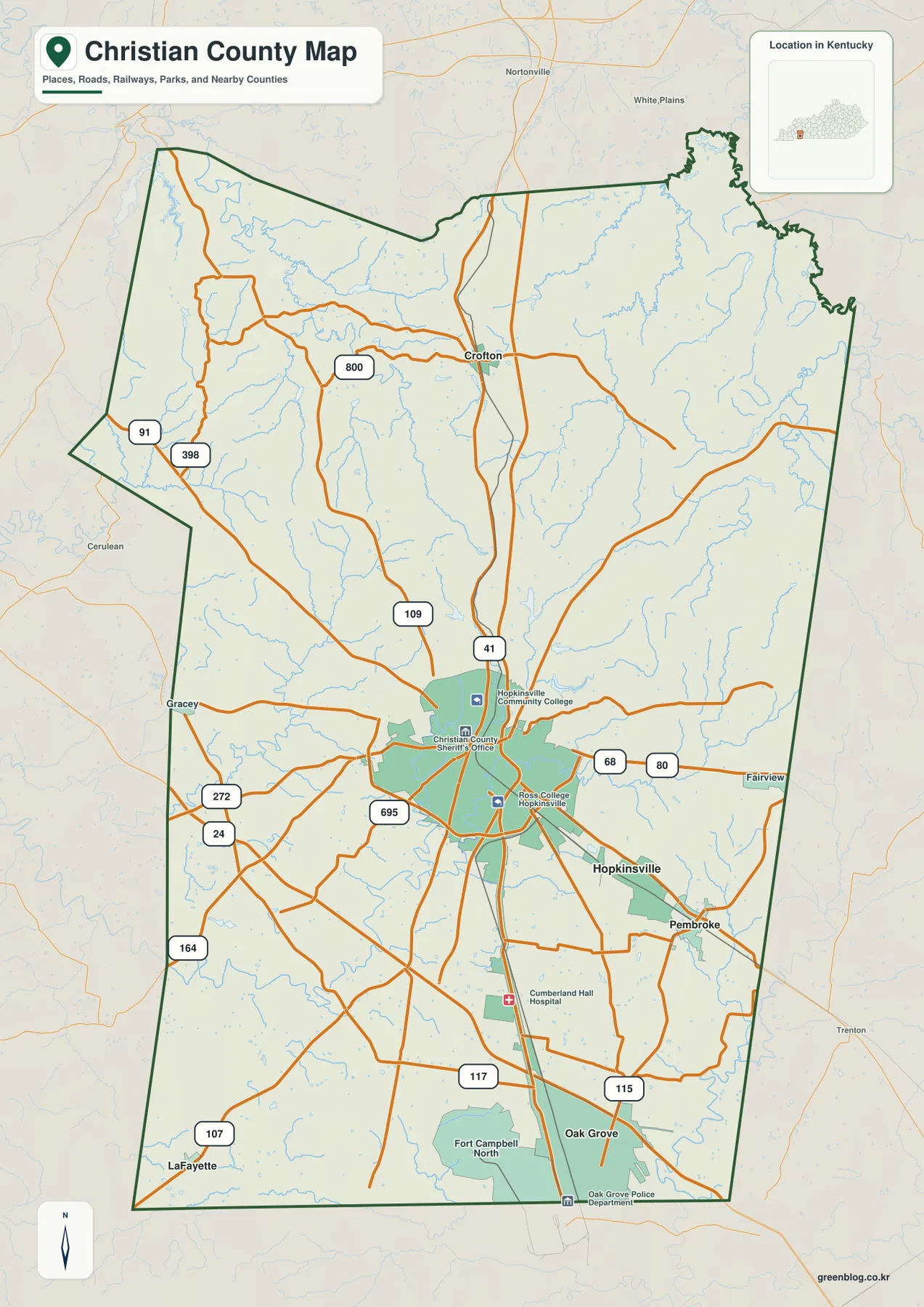
Pembroke is easy to spot east of Hopkinsville along the U.S. 68 and KY 80 corridor. Gracey appears west of the city, while Crofton sits much farther north where KY 800 and nearby roads branch through a more broken landscape. Lafayette occupies a very different position near the southwestern corner. Looking at these places together makes clear why a single close-up of Hopkinsville would not be enough to understand the county: Christian County extends far north and west beyond the main urban area.
The county government describes Christian County and its county seat, Hopkinsville, as part of southwestern Kentucky’s Pennyroyal region. Its official overview places Hopkins and Muhlenberg counties to the north, Todd County to the east, Trigg County to the west, and Montgomery and Stewart counties in Tennessee to the south. Those relationships are useful when reading the map edge, especially the long southern state line and the more irregular northern and eastern boundaries.
Five mapped communities reveal how widely settlement is spread
The city map strips away much of the road detail and highlights five communities: Hopkinsville, Oak Grove, Pembroke, Crofton, and Lafayette. The map ranks Hopkinsville first and Oak Grove second, followed by Pembroke, Crofton, and Lafayette. More useful than the ranking itself is the geography. Hopkinsville and Oak Grove occupy the southern part of the county, Pembroke lies to the east, Crofton stands far to the north, and Lafayette sits close to the southwestern boundary.
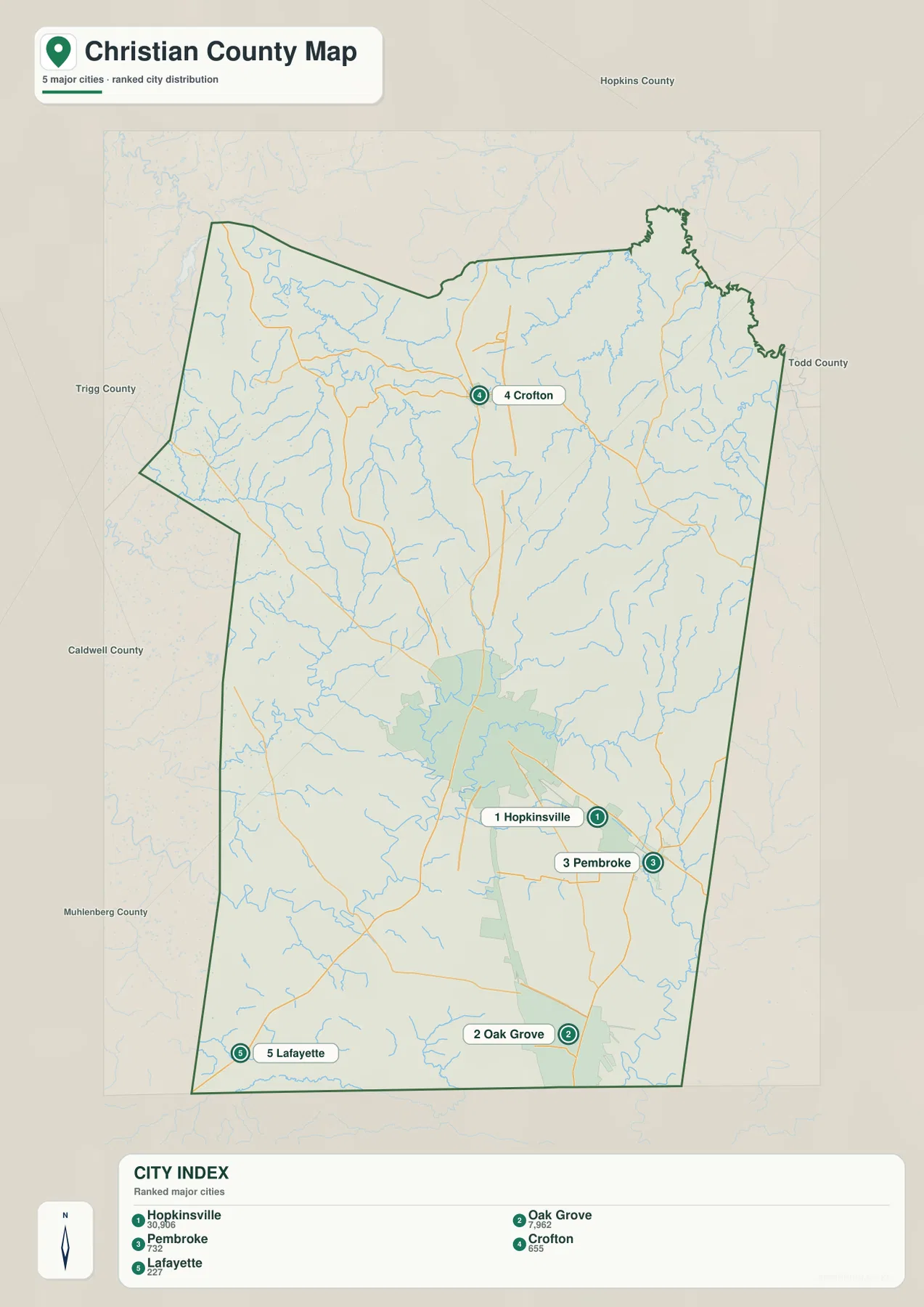
This simplified view is especially useful before switching back to the road map. Someone explaining the route from Hopkinsville to Crofton can first show the north-south relationship without the distraction of every state route, then use the general map for the actual road context. The same method works for Lafayette, which looks relatively isolated from the other named communities, and for Pembroke, which occupies a distinct position east of the Hopkinsville area.
Christian County’s official Communities page lists the same five places—Crofton, Hopkinsville, Lafayette, Oak Grove, and Pembroke—as community references. That makes the city map useful as a quick orientation graphic for names that also appear in county information. It does not show driving times or road mileage between them, so trip planning still requires current navigation data. Its strength is the clean comparison of where each community sits inside a very large county outline.
Water divides between the Tradewater, Pond, Little, and Red River systems
The water map shows that Christian County does not drain toward a single obvious river running through its center. In the northwest, the Tradewater River reaches the county edge near Lake Beshear, with Pennyrile Lake located farther south. The northeastern corner is shaped by the East Fork Pond River, while the West Fork Pond River crosses the north-central interior and collects a dense set of smaller tributaries. This network helps explain why the northern half of the relief map is cut by so many narrow valleys.
Farther south, the Little River system becomes the more useful reference. South Fork Little River extends across the central and eastern portion, North Fork Little River comes up through the southwest, and Little River itself appears near the southwestern side. Sinking Fork is labeled farther west, while West Fork Red River follows the southeastern edge. Several named lakes near the middle of the county—Lake Blythe, Lake Morris, Lake Tandy, and Lake Boxley—add smaller water features close to the Hopkinsville area.
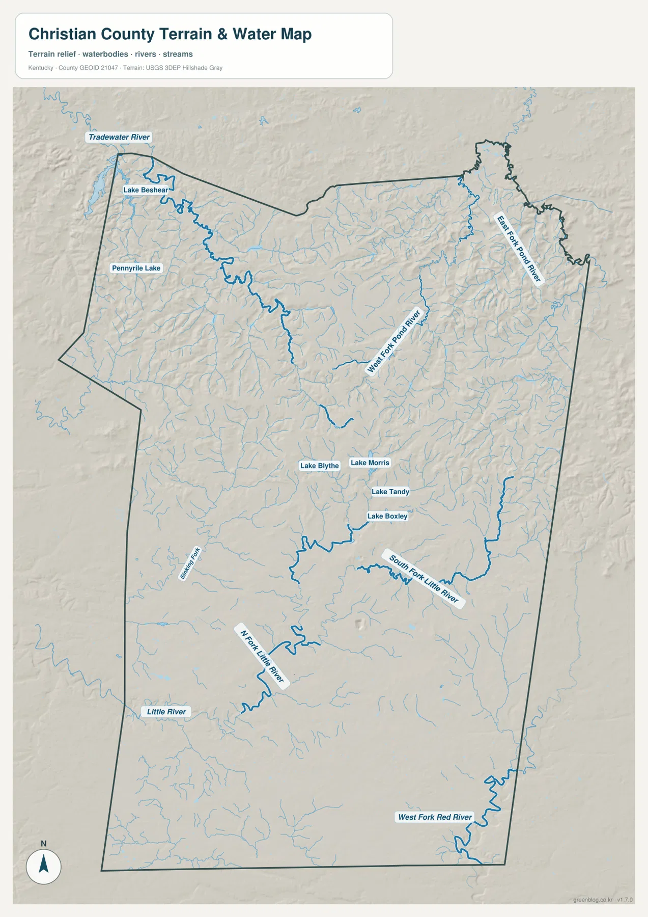
The shaded terrain beneath the blue water lines adds important context. Northern streams wind through a tighter pattern of ridges and valleys, while the Little River branches in the south cross broader, gentler ground. Lake Beshear stands out near the northwest edge because it sits next to one of the county’s more rugged areas. Around the center and south, the smaller named lakes occupy a landscape that is less sharply dissected, though short ridges and shallow valleys are still visible.
This is a reference map of named water features and terrain, not a flood map or navigation chart. It cannot tell a user whether a particular property is in a regulatory flood zone, whether a stream is currently high, or whether a lake is open for a specific activity. For those questions, current agency information is required. Here the useful question is geographic: which river system, tributary, or lake is closest to a community or section of the county?
A 74–272 m elevation range separates rugged northern ridges from gentler southern ground
The elevation map gives Christian County an actual mapped range of about 74 to 272 meters, with a mean near 173 meters. The strongest relief is concentrated across the northern half. Brown and tan ridges are especially prominent in the northwest and north-central interior, and green valleys cut between them in a dense branching pattern. The terrain near Lake Beshear and the West Fork Pond River changes elevation repeatedly over short distances, making the north look much more rugged than the county’s southern end.
South of Hopkinsville, the color pattern becomes greener and smoother. The Oak Grove area near Tennessee lies within a broad lower-elevation zone, and the valleys associated with the Little River system are more open than many of the northern creek valleys. The southeast and east-central parts still contain rolling ground, so the southern half is not completely flat, but the contrast with the ridged north is easy to see even without reading individual contour values.
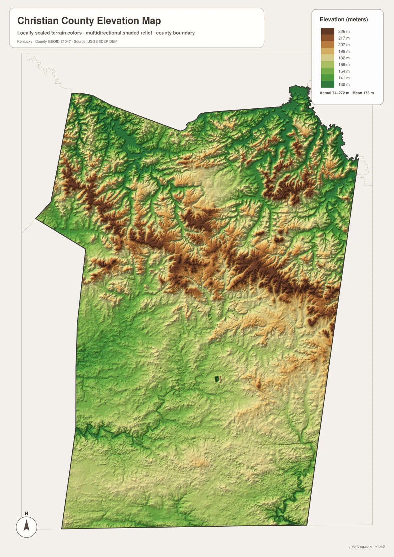
The relief also helps make sense of the road and water maps. In the north, local roads often bend through valleys or skirt higher ground, and the stream network is visibly dense around Crofton and toward the northwestern corner. In the south, the Hopkinsville-to-Oak Grove corridor crosses a more moderate surface with larger developed areas. Comparing these maps side by side gives a clearer picture of why settlement, roads, and drainage look different in the two halves of the county.
The elevation colors are generalized for county-wide comparison. They are not survey-grade measurements for a house lot, construction project, drainage design, or engineering calculation. Anyone who needs precise elevation should consult a detailed source such as the USGS 3D Elevation Program or a professional survey. For regional reading, however, the 74–272 meter span and the north-to-south contrast are enough to explain the county’s broad topographic character.
Choosing the clearest map for roads, communities, waterways, or relief
The general map works best when roads and places need to appear together. It can show Hopkinsville as the central southern hub while keeping Oak Grove, Pembroke, Crofton, Gracey, Lafayette, and the county boundary in view. The city map is better when the task is simply to compare the five highlighted communities without a dense road network. Using the city view first and the road view second can make a presentation easier to follow.
For natural geography, the water and elevation maps answer different questions. The water map is the clearer choice for Lake Beshear, the Tradewater River, the Pond River forks, the Little River system, and West Fork Red River. The elevation map is more useful when explaining the ridged north, the lower southern half, or why valleys and streams branch so differently across the county. Pairing the two gives the strongest picture of terrain because the blue water lines can be related directly to low corridors between higher ridges.
For print use, the high-resolution JPG files in the ZIP preserve more detail than the screen-sized WebP images. The four files are separated by purpose, so users can choose one map instead of crowding every layer into a single page. Current driving directions, facility access, flood conditions, land ownership, and legal boundaries should always be checked in the appropriate up-to-date official source rather than inferred from these reference maps.
Frequently Asked Questions
Which map is best for comparing Hopkinsville, Oak Grove, Pembroke, Crofton, and Lafayette?
The city map is the cleanest choice because it highlights all five communities without the full road network. It quickly shows Hopkinsville and Oak Grove in the south, Pembroke to the east, Crofton far to the north, and Lafayette near the southwestern corner. For actual route context, switch to the general map and add U.S. 41, U.S. 68, KY 80, and the surrounding state roads.
Can Lake Beshear and the Little River system be viewed on the same map?
Yes. The water map shows Lake Beshear near the Tradewater River in the northwest and the Little River, North Fork Little River, and South Fork Little River farther south. Their separation is useful because it shows that Christian County’s drainage is divided among several river systems rather than organized around one central channel.
What is the most obvious feature of the 74–272 m elevation map?
The clearest contrast is between the rugged, closely spaced ridges of the northern half and the broader lower terrain around Hopkinsville, Oak Grove, and the Tennessee border. The mean elevation is about 173 meters, but the colors are intended for county-scale comparison and should not be treated as precise elevation values for an individual property.
Map File Information
The original Christian County maps used on this page are bundled as high-resolution JPG files suitable for printing and close inspection. Each original is 3638 × 2572 px, providing more room to examine place labels, roads, waterways, and relief than the screen-sized WebP versions.
- Included Files: county map, city map, water map, elevation map
- File Type: JPG
Related Maps
Sources and references
County location and regional background can be checked on the official Christian County About page, and the five community names are listed by the Christian County government Communities page. Visitor-oriented local information is available from the Hopkinsville-Christian County Convention & Visitors Bureau. Boundary data can be referenced through U.S. Census Bureau TIGER/Line, hydrography through USGS National Hydrography, and elevation through the USGS 3D Elevation Program.
Green Map creates custom-edited map images using open geographic data sources such as geoBoundaries, Natural Earth, OpenStreetMap, and government open data. These maps are edited visual materials, not raw data files, and are provided for education, documents, presentations, and graphic reference.