Boyd County forms Kentucky’s northeastern corner along the Ohio River, with Ashland and Catlettsburg occupying the county’s main urban corridor. The east side follows large river valleys, while the interior quickly rises into narrow Appalachian ridges cut by the East Fork Little Sandy River and dozens of smaller creeks. I-64, US 23, and US 60 tie the river cities to Cannonsburg and the surrounding hills, so the contrast between developed riverfront and rugged interior terrain is easy to see. High-resolution map files are available for download in the section below.
This guide follows Ashland and Catlettsburg, the major transportation corridors, the Ohio and Big Sandy rivers, the East Fork Little Sandy River, and relief ranging from about 157 to 349 meters. WebP previews are included for quick viewing, and the same maps can be downloaded as high-resolution JPG files in one ZIP for printing, classroom work, or close study.
Table of Contents
Ashland and Catlettsburg concentrate settlement along the county’s eastern river edge
Ashland is the largest urban center on the map, stretching along the Ohio River with Westwood and Ironville immediately to the west. Farther south, the developed corridor continues through the Cannonsburg area toward Catlettsburg. I-64 crosses the middle of the county, while US 23 and US 60 provide major links through the northeastern urban district.
Catlettsburg is smaller than Ashland but serves as the Boyd County seat. The Boyd County Clerk’s main office and county government address are in Catlettsburg, giving the city an administrative role that is not reflected by population size alone. Its location near the Big Sandy–Ohio confluence also makes it a key geographic reference on the eastern border.
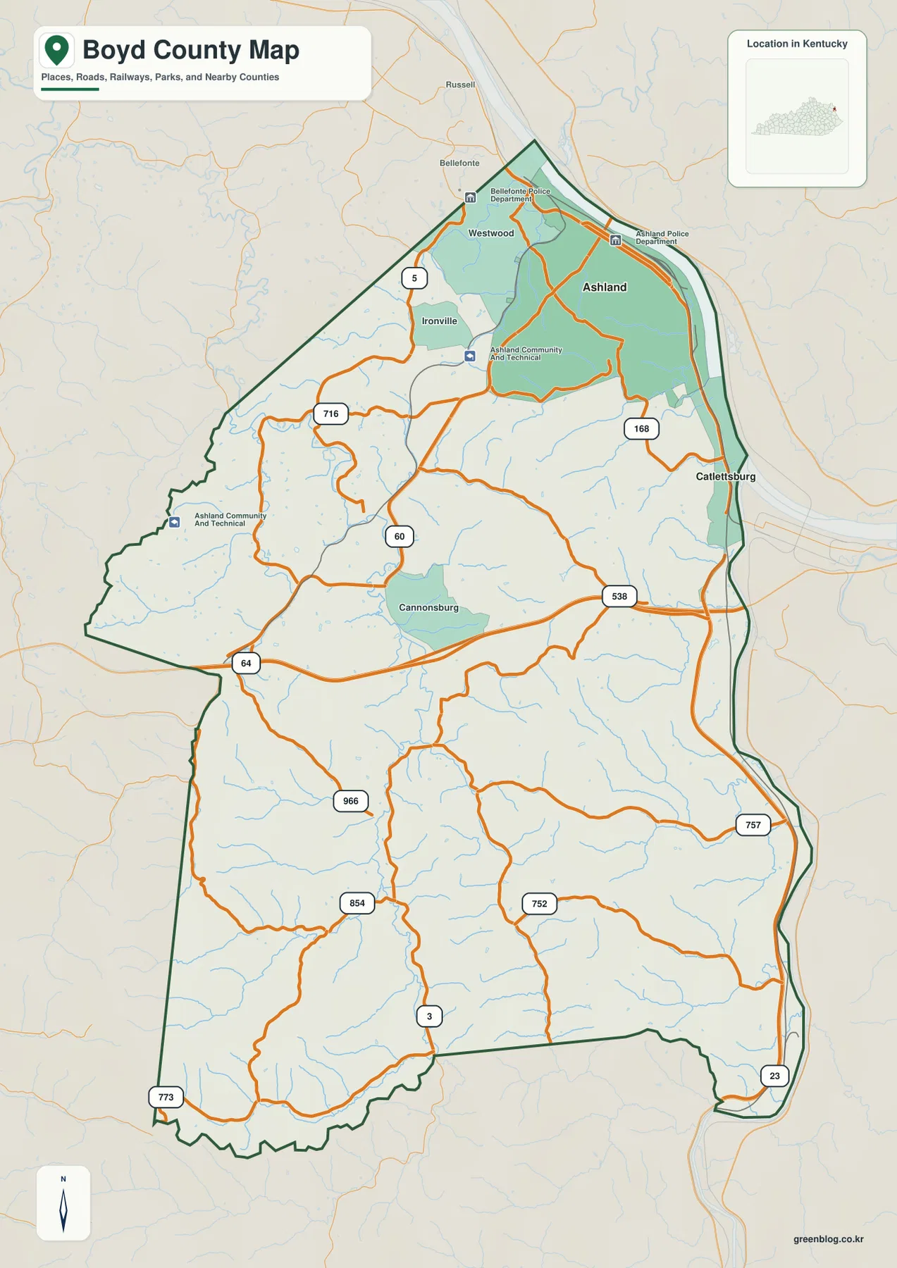
The western edge meets Greenup and Carter counties, while the southwest approaches Lawrence County. Development thins rapidly away from Ashland and Catlettsburg, and local roads begin to follow creek valleys and low crossings between ridges rather than a regular grid.
The city index compares Ashland at 21,295 with Catlettsburg at 1,557
The supplied city panel ranks Ashland at an index value of 21,295 and Catlettsburg at 1,557. These are map index values rather than current official population estimates. They are useful for showing the relative prominence of the two named cities, but they should not be quoted as current census counts.
Both places lie on the eastern side of Boyd County, yet their settings differ. Ashland occupies a long Ohio River urban strip with adjoining neighborhoods and commercial districts, while Catlettsburg sits in a tighter river setting near the mouth of the Big Sandy River.
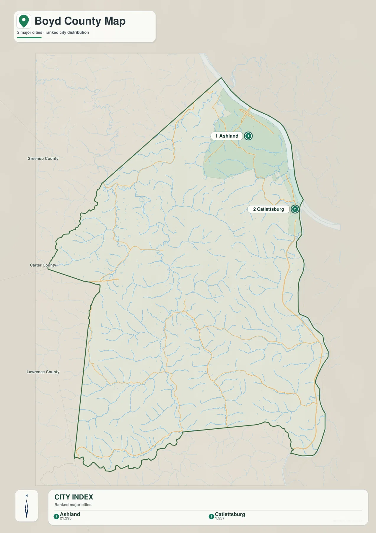
Westwood, Ironville, and Cannonsburg are visible on the general map but are not part of this ranked city panel. The city image is therefore a simplified major-city view rather than a complete settlement inventory.
The Ohio and Big Sandy rivers define the east while the East Fork Little Sandy River cuts through the interior
The Ohio River is the county’s largest water feature and borders the Ashland side of the map. Boyd County Emergency Management describes the area as the confluence of the Ohio and Big Sandy rivers where Kentucky, Ohio, and West Virginia meet, giving the county a distinctive tri-state position.
Inside the county, the East Fork Little Sandy River forms the strongest north–south drainage corridor. Williams Creek enters from the west, while Bear Creek and many short tributaries descend from the eastern hills. Woods Creek, Little Hood Creek, and Keys Creek drain the northern interior toward the Ohio River, and Whites Creek cuts the southeastern hills toward the Big Sandy side.
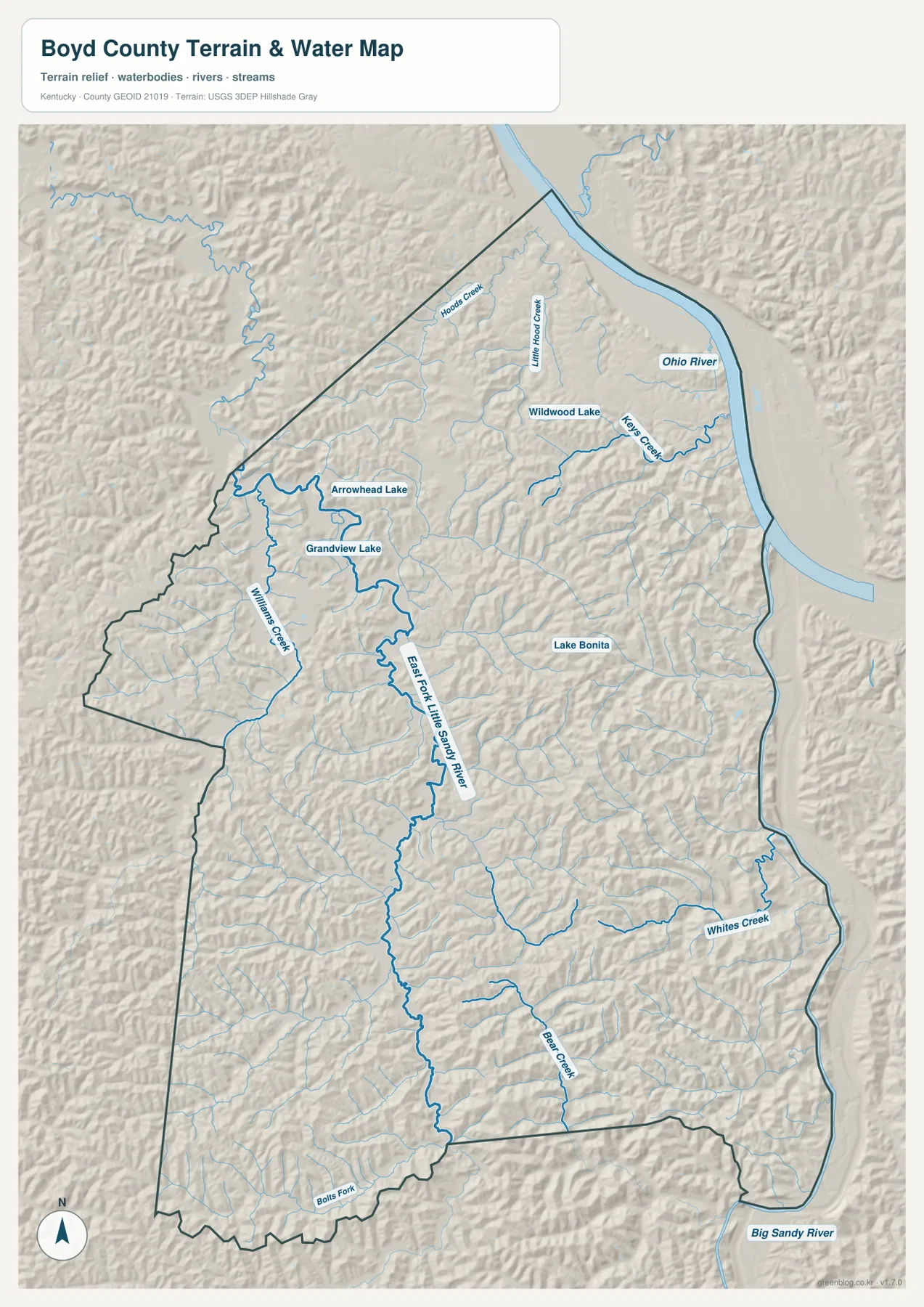
Arrowhead Lake and Grandview Lake appear in the northwest, Wildwood Lake sits southwest of Ashland, and Lake Bonita provides another interior water reference. Large reservoirs do not dominate Boyd County; instead, a dense network of streams and small lakes helps define the narrow valleys between ridges.
This image is intended for geographic reference rather than floodplain, navigation, water-quality, parcel, or legal-boundary decisions. Current agency information should be used whenever river stage, access, safety, or property decisions depend on water conditions.
Relief from 157 to 349 meters reveals steep Appalachian ridges behind the river cities
The elevation surface ranges from about 157 to 349 meters, with a mean near 226 meters. The Ohio and Big Sandy river margins appear as the lowest green areas, and the East Fork Little Sandy River forms another long low corridor through the interior. Between those valleys, tightly packed ridges rise repeatedly across most of the county.
The southern and southwestern sections show especially dense relief, with narrow crests separated by branching creek valleys. Even north of I-64, the land rises quickly west of Ashland, so the riverfront city sits close to much rougher terrain than a road map alone might suggest.
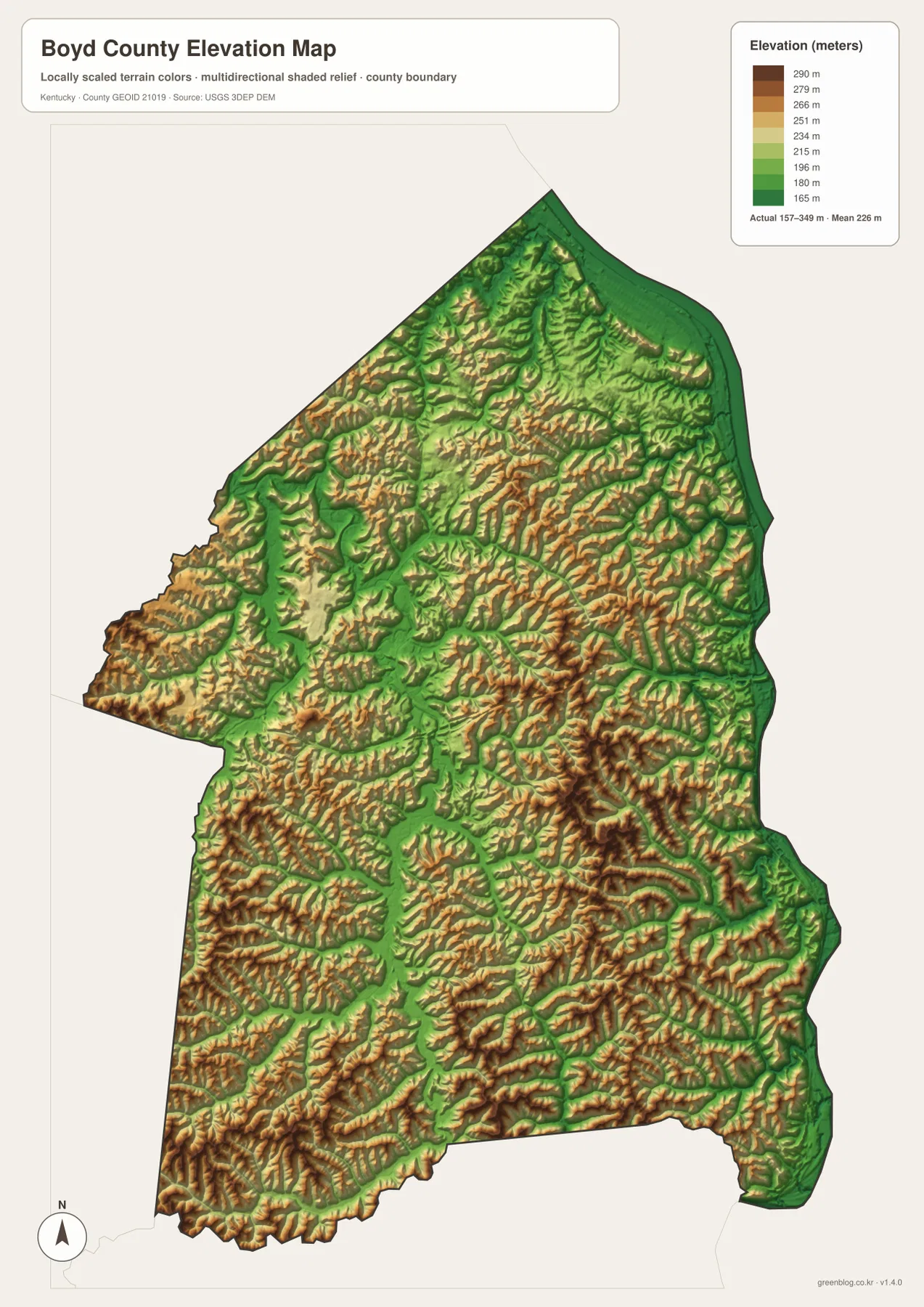
The East Fork Little Sandy River creates a continuous low path through the center, but the slopes on either side rise quickly. Whites Creek and Bear Creek show the same pattern on a smaller scale. This repeated valley-and-ridge terrain explains why many local roads bend with drainage lines instead of taking direct straight routes.
The elevation surface is generalized for county-scale comparison. It is not survey-grade or engineering-grade measurement and should not be used for parcel elevations, construction grades, drainage design, or legal boundary work.
Catlettsburg combines county government with a major river confluence
Boyd County government and the County Clerk’s main office are based in Catlettsburg. Although Ashland is the larger city, Catlettsburg remains the administrative center and occupies a strategic place where the Big Sandy River reaches the Ohio River.
Boyd County Emergency Management emphasizes the same geography, describing the county at the Ohio–Big Sandy confluence where Kentucky, Ohio, and West Virginia meet. Northbound US 23 connects Catlettsburg directly with Ashland, while the route south follows the Big Sandy valley toward Lawrence County. Water and terrain therefore explain the transportation corridor as clearly as the road network does.
US 23 begins the Country Music Highway story in the Ashland area
Kentucky Tourism describes the Country Music Highway as the US 23 heritage route running south from Ashland through eastern Kentucky. In Boyd County, US 23 links Ashland and Catlettsburg before continuing along the Big Sandy corridor, giving the county the northern gateway role on a route strongly associated with Appalachian music.
Ashland’s Paramount Arts Center gives that music heritage a physical landmark. The theater’s official history says it opened in 1931 as an Art Deco movie palace and was renamed the Paramount Arts Center in 1972. It continues to function as a regional performance venue in the same Ohio River city that anchors the northern end of the Country Music Highway.
The Highlands Museum connects Ashland’s river history with regional music heritage
The Highlands Museum & Discovery Center in downtown Ashland interprets both regional history and local culture. Its exhibits include a Country Music Heritage Hall and a Poage’s Landing river exhibit, connecting the US 23 music story with the Ohio River transportation history that shaped the city.
That combination fits the map well. Ashland developed on a major river edge with rail, road, industrial, and cultural connections, while the rest of Boyd County quickly transitions into creek-cut Appalachian hills. The county’s identity comes from both settings rather than from either one alone.
A short trip away from Ashland quickly changes from river city to creek-cut hills
Travel southwest from Ashland toward Cannonsburg and the continuous urban landscape begins to thin. The East Fork Little Sandy River and smaller tributaries become stronger geographic references, and I-64 provides the main east–west crossing through terrain that is otherwise broken into many narrow valleys.
South from Catlettsburg, US 23 stays close to the Big Sandy side of the county. Routes such as KY 3, KY 854, and KY 966 head into higher interior ridges instead. The difference between river corridor, interstate crossing, creek valley, and upland ridge occurs over short distances and is one of the most useful features to compare across the supplied maps.
For posters, classroom prints, or presentation slides, use the original JPG files in the download archive rather than enlarging the web previews. Small route labels, creek names, city-index text, and the elevation legend remain clearer at the higher resolution.
Frequently Asked Questions
Are the Ashland 21,295 and Catlettsburg 1,557 values current populations?
No. They are map index values supplied with this package rather than current official population estimates. Use them for relative city context only, and consult current Census data when an official population figure is required.
Why are the Ohio and Big Sandy rivers so important to Boyd County geography?
They define the county’s eastern river setting and meet near Catlettsburg in the tri-state area where Kentucky, Ohio, and West Virginia come together. The location helps explain why Ashland and Catlettsburg, major roads, industry, and historic transportation developed along the eastern edge.
Can the 157–349 meter elevation image be used for surveying?
No. It is a generalized county-scale terrain image for comparing low river and creek valleys with higher Appalachian ridges. Parcel elevations, engineering grades, drainage design, and legal boundary work require more precise official data and, where needed, professional surveying.
Map File Information
The archive contains the Boyd County, Kentucky general county map, city map, terrain-and-water map, and elevation map as original high-resolution JPG files.
- Included Files: Use only the versions confirmed in the article and supplied images
- File Type: Use the confirmed download contents
- Intended Use: Printing, education, presentations, and map-based projects
Related Maps
Sources and references
- Boyd County, Kentucky official site — county government and Catlettsburg administrative information
- Boyd County Emergency Management: About Us — Ohio–Big Sandy confluence and tri-state setting
- Kentucky Tourism: Country Music Highway — US 23 music heritage route beginning in the Ashland area
- Paramount Arts Center: History — the 1931 theater and Ashland performing-arts history
- Highlands Museum & Discovery Center — regional river and music-history exhibits in Ashland
- USGS 3D Elevation Program — elevation and terrain reference data
Green Map creates custom-edited map images using open geographic data sources such as geoBoundaries, Natural Earth, OpenStreetMap, and government open data. These maps are edited visual materials, not raw data files, and are provided for education, documents, presentations, and graphic reference.