Van Buren County occupies the southeastern corner of Iowa, and the broad bends of the Des Moines River give the county a geographic shape that is easy to recognize on a map. This Van Buren County Iowa Map page combines communities, numbered highways, tributaries, water bodies, and elevation so the county can be understood as one connected landscape. The WebP images in the article are lightweight previews, while the download box near the end provides the same reference, city, water-and-terrain, and elevation maps as full-resolution JPG files.
Keosauqua is the most useful starting point because it sits near the middle-south of the county inside a pronounced river bend. Bonaparte lies farther east along the Des Moines River, and Farmington marks the southeastern side. Birmingham and Stockport help define the north, while Milton and Cantril anchor the southwest. Numbered routes including Iowa 1, Iowa 2, Iowa 16, Iowa 81, and Iowa 112 make road orientation straightforward. Once those places are located, the water and elevation maps explain why so many local roads and settlements occupy narrow ridges or crossings between deeply cut stream valleys.
Table of Contents
The Des Moines River bend that organizes central Van Buren County
The reference map is dominated by the Des Moines River rather than by a single straight highway. The river enters from the west, curves across the central part of the county, makes a broad turn around the Keosauqua area, and continues southeast toward Bonaparte and Farmington. That path creates an immediate framework for reading the county. Instead of memorizing every road, a reader can first locate Keosauqua and then follow the river upstream or downstream to place nearby towns, crossings, and tributary valleys.
Keosauqua is the county seat and has long been associated with the large bend in the Des Moines River. Local community information even connects the town name with the idea of a river bend. The physical setting is visible on the supplied maps: the river swings around the area in a wide curve, while tributary valleys and higher ground rise nearby. This makes Keosauqua more than an administrative label on the map. It is also the best geographic reference point for moving between the northern roads, the eastern river towns, and the southern communities.
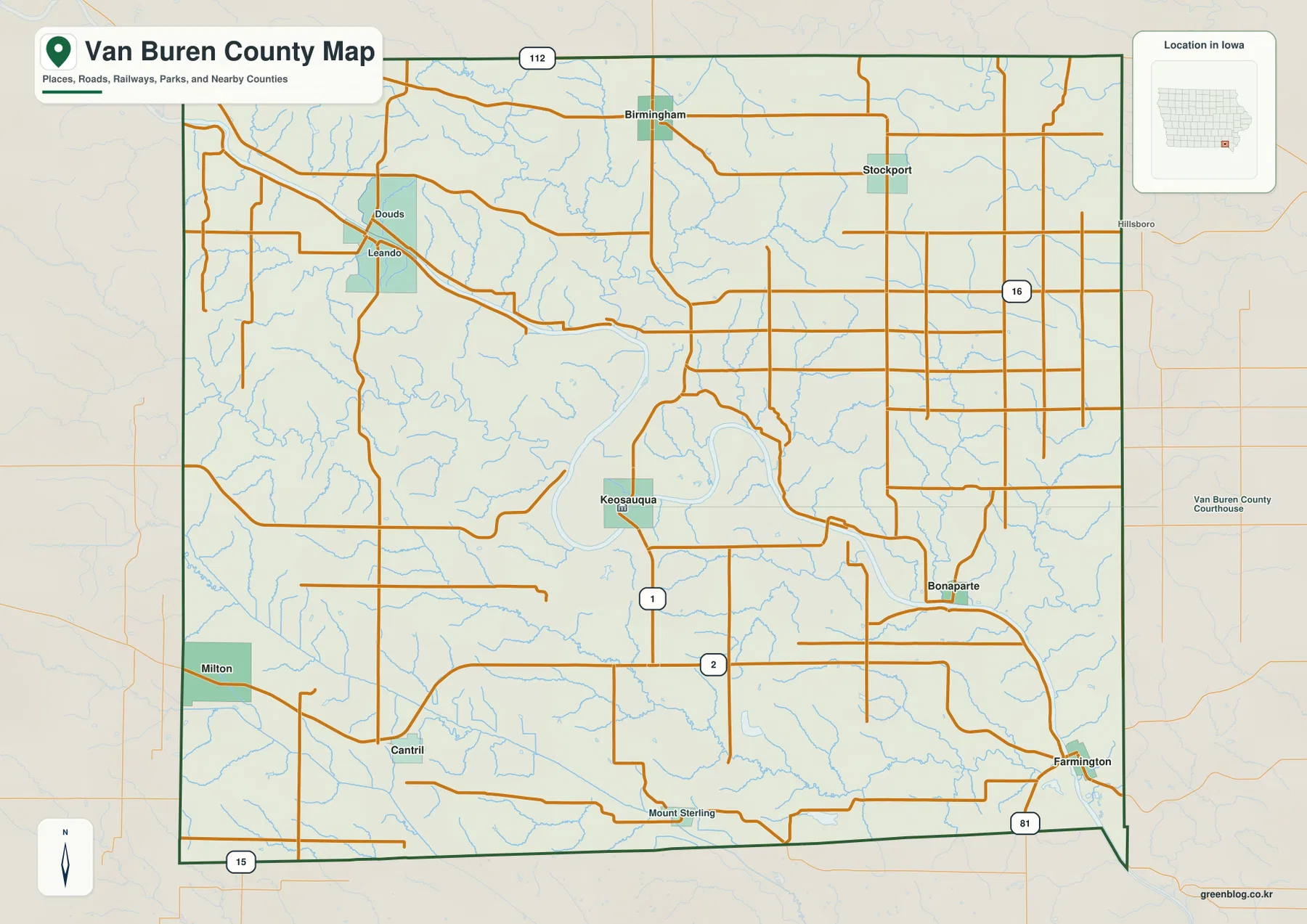
Iowa 1 is an especially useful north-south marker because it passes through the Keosauqua area. Iowa 2 crosses the southern part of the county, providing a second strong reference line. Iowa 16 appears in the eastern half, Iowa 81 reaches the Farmington area, and Iowa 112 is visible near the northern boundary. These routes do not form one simple grid because the river valleys repeatedly interrupt the terrain. Rural roads often bend, descend, or change direction as they approach the Des Moines River and its tributaries.
Smaller labels on the map add useful context. Douds and Leando sit northwest of Keosauqua where roads, streams, and the river corridor come close together. Stockport is farther east and away from the main river, while Bonaparte returns to the river corridor. This contrast is one of the defining features of Van Buren County: some communities are closely tied to the Des Moines River, while others occupy uplands or tributary country several miles from the main channel. The full-resolution reference map is useful when those smaller names matter.
Six highlighted communities from Birmingham to Farmington
The city map strips away much of the road detail and emphasizes six communities: Keosauqua, Farmington, Milton, Birmingham, Cantril, and Bonaparte. Their spacing makes the county easier to understand at a glance. Birmingham sits in the north, Keosauqua occupies the middle-south, Bonaparte is east of it near the river, and Farmington lies near the southeastern edge. Milton and Cantril form a separate southwestern group, showing that the county does not have a single line of settlement running from north to south.
The ranking numbers printed on the city map are best treated as a visual guide to the map set rather than as a substitute for current population estimates. Their practical value is that they identify the communities chosen as county-wide reference points. Keosauqua stands out in the middle, while Farmington and Milton help establish the eastern and western sides of the southern county. Bonaparte fills an important gap along the Des Moines River between Keosauqua and Farmington, making it a useful landmark when following the river downstream.
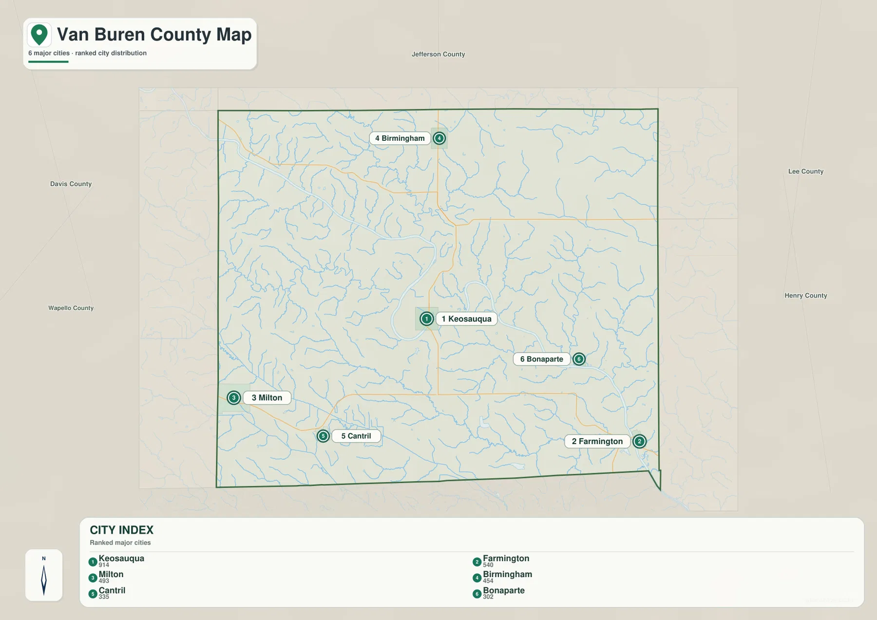
The city map becomes more informative when it is compared with the river map. Keosauqua and Bonaparte are closely associated with the Des Moines River, while Birmingham is surrounded by smaller northern tributaries. Milton and Cantril sit closer to the Fox River and Big Indian Creek systems in the southwest. Farmington is near the point where the main river leaves the county. Those differences explain why the communities appear scattered instead of clustering around a single highway corridor.
County context also matters. Jefferson County lies to the north, Wapello and Davis counties are to the west, and Henry and Lee counties are on the eastern side. The southern edge of Van Buren County reaches Iowa’s state boundary. That position makes Farmington, Cantril, and the southern river and creek systems especially useful for understanding where southeastern Iowa meets the state line. A simple city map is often the clearest choice when the goal is orientation before moving to more detailed road or terrain information.
Lick Creek, Chequest Creek, and tributaries feeding the main river
The water-and-terrain map reveals how strongly the Des Moines River controls drainage across the center of the county. Its broad channel is joined by many smaller streams. Lick Creek and Little Lick Creek descend through the north-central area, while Chequest Creek approaches from the west. On the eastern side, Little Cedar Creek, Cedar Creek, Rock Creek, Honey Creek, Reeds Creek, and Flat Rock Creek occupy separate valleys that eventually connect with the larger river system.
The names can appear dense on first inspection, but the network is easier to follow by starting with the Des Moines River and tracing one tributary at a time. The small streams repeatedly cut into higher ground, creating narrow valleys that are also visible on the elevation map. Where several tributaries meet the main river, the valley floor widens. Elsewhere the river is closely bordered by steeper slopes. This pattern is particularly evident around the large bends near Keosauqua and in the downstream corridor toward Bonaparte.
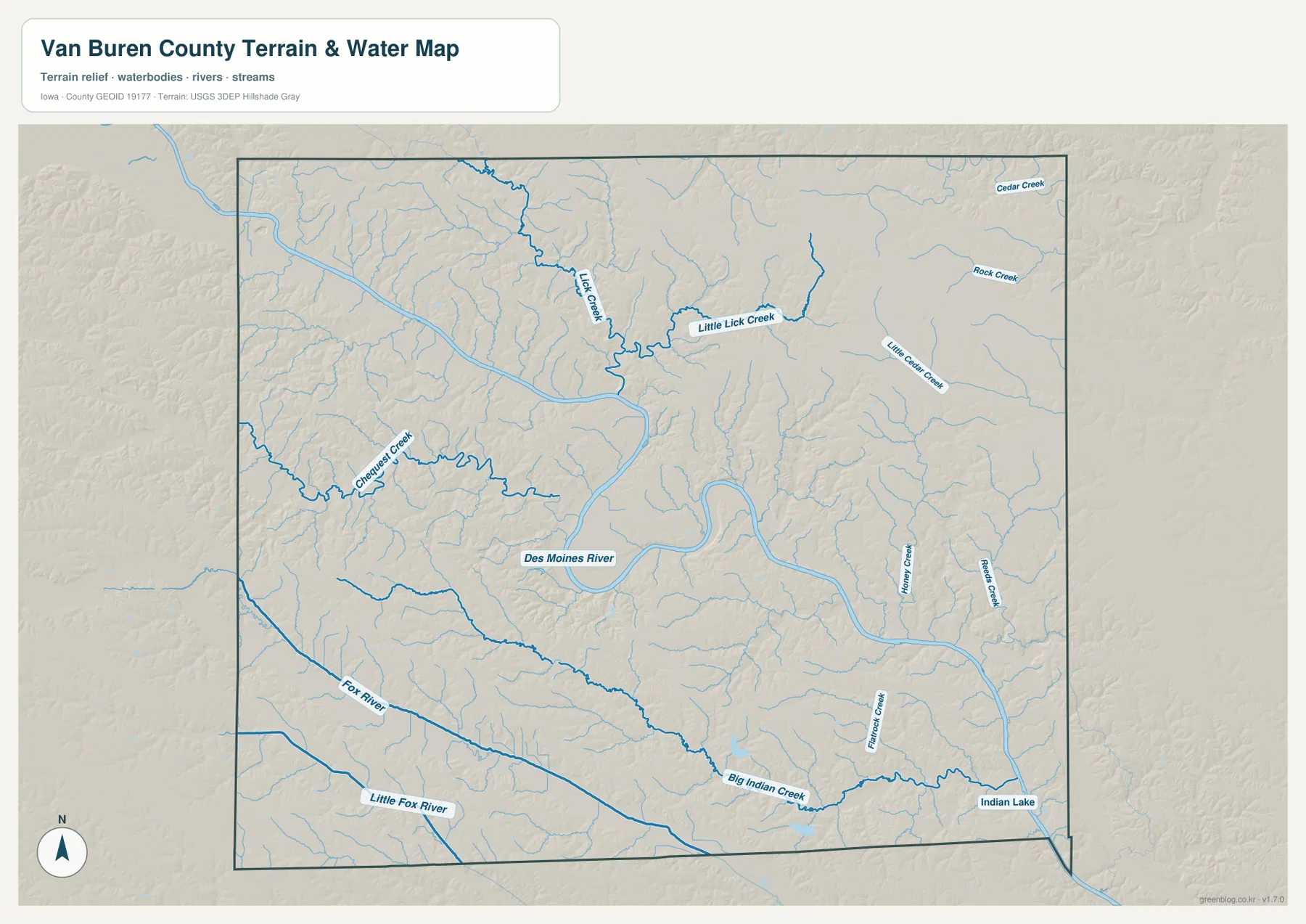
The Iowa Department of Natural Resources lists the Des Moines River from the Ottumwa dam to Farmington as a river segment running through Wapello and Van Buren counties. That official description matches the broad west-to-southeast path visible here. The map is not a live river-stage, flood-risk, or navigation product, however. Anyone planning boating, fishing, or travel close to the water should check current DNR information, local notices, and weather conditions rather than relying on a static county map.
Near Keosauqua, Lacey-Keosauqua State Park adds another useful piece of geographic context. Iowa DNR describes the park as a landscape of oak-hickory bluffs and valleys along the Des Moines River. Those bluffs are consistent with the strong relief visible beside the river on the supplied terrain maps. The county reference map is best for finding Keosauqua and nearby roads, while the water and elevation views explain the physical setting that gives the river corridor its distinctive shape.
Fox River, Big Indian Creek, and the southern drainage network
The southern half of Van Buren County has a second set of water features that should not be overlooked. The Fox River and Little Fox River extend across the southwest, near the broader Milton and Cantril area. Farther east, Big Indian Creek forms a strong drainage line across the south-central part of the county. Instead of flowing through one broad flat plain, these channels occupy narrow valleys separated by rolling uplands, a pattern that becomes even clearer in the elevation map.
Indian Lake is another recognizable feature in the southeastern part of the county, close to Farmington. Iowa DNR’s lake information identifies Indian Lake in Van Buren County near Farmington, making it a useful official reference for the water body shown on the map. Big Indian Creek and nearby tributaries help connect this part of the county to the larger drainage network, while Flat Rock Creek adds another narrow valley close to the eastern side.
Comparing the north and south reveals why a single description of the county’s waterways would be incomplete. The central and northern landscape is strongly organized around the Des Moines River and tributaries such as Lick Creek and Chequest Creek. The southwest has the Fox River system, while Big Indian Creek and Indian Lake help define the southeast. Together these streams divide the uplands into many short ridges and slopes, giving Van Buren County a much more dissected appearance than a flat road map might suggest.
A 159–247 meter landscape of low river corridors and rolling uplands
The elevation map reports an actual mapped range of about 159 to 247 meters, with a mean near 215 meters. Greens represent the lower parts of the county and browns indicate higher ground. The most obvious low feature is the Des Moines River valley, which forms a broad green ribbon through the middle of the map. Its sweeping curves are recognizable even without city labels, especially where the channel bends around the Keosauqua area before continuing toward Bonaparte and Farmington.
Higher terrain rises quickly on both sides of the river. The southwest contains extensive brown ridges that are cut by the Fox River and smaller tributaries, while the north and east are divided by many narrow green stream valleys. The landscape therefore does not look like one simple slope from a high side to a low side. Elevation changes repeatedly over short distances as ridges give way to creek bottoms and then rise again. That texture is one of the clearest physical differences between Van Buren County and flatter parts of Iowa.
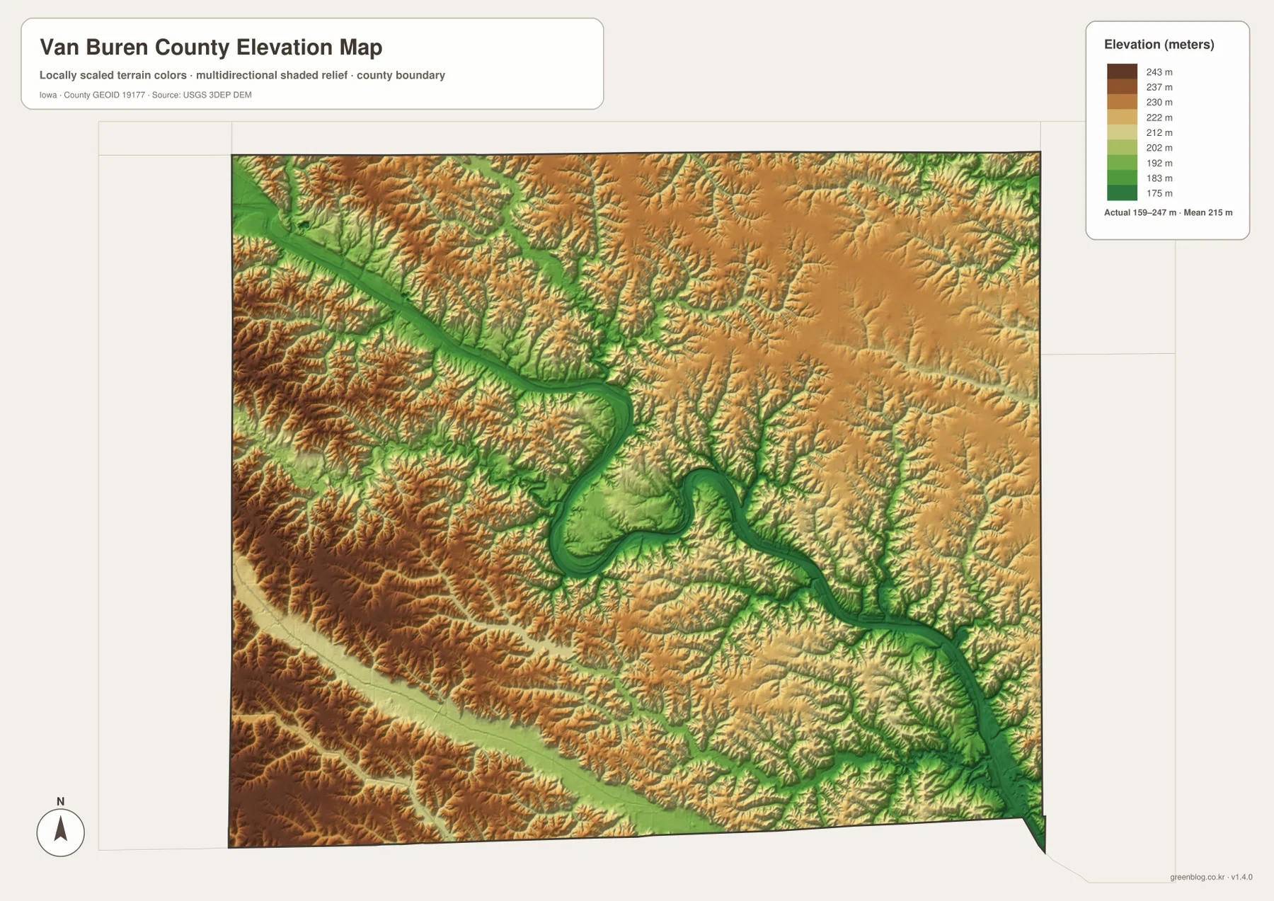
The close match between water and elevation is useful for map reading. Lick Creek, Chequest Creek, the Fox River, and Big Indian Creek each follow lower bands through surrounding hills. When a stream name is difficult to read on the water map, its valley can often be recognized on the elevation surface. The reverse is also true: an unexplained green corridor on the elevation map can often be identified by switching back to the labeled water map. Using the two maps together is more informative than treating elevation and drainage as separate subjects.
The 159–247 meter range is intended for county-wide geographic comparison, not for parcel surveying or engineering. It can show that the river valleys are lower than nearby ridges, but it does not provide a certified elevation for a house, bridge, field corner, or construction site. Detailed design work should use the underlying USGS elevation data and professional survey information when required. For general geography, the elevation map is most valuable for explaining why the county’s roads, streams, and towns occupy such a varied rolling landscape.
Using the map set for roads, towns, water, and terrain
Start with the reference map when the main question is about a road, town, or county-wide position. Keosauqua, Iowa 1, and Iowa 2 provide a practical center, while Bonaparte and Farmington help establish the eastern and southeastern river corridor. Birmingham and Stockport clarify the north, and Milton and Cantril are useful southwestern anchors. Because many smaller roads and place names are included, the reference map benefits from a large screen or a full-resolution download when close reading is important.
The city map is better when the goal is simply to compare the highlighted communities without the distraction of the rural road network. For physical geography, use the water and elevation maps as a pair. Trace the Des Moines River or Big Indian Creek on the water map, then switch to the elevation map to see the corresponding low corridor and the higher ridges beside it. This method works well for classroom assignments, local-history context, trip planning at a broad scale, or reports that need a clear explanation of how settlements relate to terrain.
Printing needs also differ by map type. The city map remains readable at smaller sizes because it has fewer labels. The reference and water maps contain many small road and stream names, so larger prints preserve more detail. The elevation map relies on color gradients and shaded relief, making a color display or color printer the best choice. The archive below contains the four original JPG images at 3638 × 2572 pixels each, providing more detail than the lightweight WebP versions embedded in the article.
Frequently Asked Questions
What is the easiest landmark for orienting a Van Buren County map?
Keosauqua is the best starting point because it is the county seat, lies inside a major bend of the Des Moines River, and is close to Iowa 1. From there, the river leads east toward Bonaparte and southeast toward Farmington. Birmingham lies to the north, while Cantril and Milton help define the southwest. Using Keosauqua together with the river is usually faster than trying to memorize the entire rural road network at once.
Which waterways are useful south of the main Des Moines River corridor?
The Fox River and Little Fox River are prominent in the southwest, while Big Indian Creek crosses the south-central area and helps organize the drainage toward the southeast. Indian Lake is shown west of Farmington, with nearby tributaries including Flat Rock Creek. These features are useful because they reveal a second set of valleys beyond the large Des Moines River bends and explain much of the rolling terrain in the southern county.
Can the 159–247 meter elevation range be used as an exact property elevation?
No. The range summarizes county-wide terrain and is appropriate for comparing low river valleys with higher uplands. It is not a parcel survey or a certified point elevation. Construction, drainage design, engineering, or legal boundary work should use the underlying USGS elevation data and professional survey information when needed. The map is intended for regional geographic interpretation rather than site-specific measurement.
Map File Information
The download contains the Van Buren County reference map, city distribution map, water-and-terrain map, and elevation map as full-resolution JPG files. They are better suited to close viewing and printing than the lightweight WebP previews in the article.
- Included Files: Van Buren County reference map, city map, water and terrain map, and elevation map
- Printable Size: 3638 × 2572 px for each JPG
Related Maps
Sources and References
The geographic descriptions above are based primarily on the supplied Van Buren County map previews. County and Keosauqua context, river information, and park details were checked against the local and official sources below, along with standard federal references for boundaries, hydrography, and elevation.
- Engage Keosauqua – About Keosauqua – local information about Keosauqua, its history, and its setting on the Des Moines River bend
- Iowa DNR – Lacey-Keosauqua State Park – official information about the river bluffs, valleys, and park near Keosauqua
- Iowa DNR – Rivers & Streams – official river information including the Des Moines River segment from Ottumwa to Farmington
- U.S. Census Bureau TIGER/Line Shapefiles – county boundary, roads, and place-reference data
- USGS National Hydrography – national river, stream, and water-feature data
- USGS 3D Elevation Program – national elevation and terrain data
Green Map creates custom-edited map images using open geographic data sources such as geoBoundaries, Natural Earth, OpenStreetMap, and government open data.
These maps are edited visual materials, not raw data files, and are provided for education, documents, presentations, and graphic reference.