Hall County combines one of central Nebraska’s largest urban centers with the broad Platte River lowlands and higher agricultural country to the west. Grand Island dominates the east-central part of the county, while Wood River, Alda, Cairo, and Doniphan occupy smaller road and creek settings around it. Multiple Platte channels spread across the south, and Prairie Creek, Silver Creek, Wood River, and other tributaries divide the gently rising terrain farther north and west.
This page explains Grand Island and the surrounding communities, the straight-line distances printed on the city map, U.S. 30, 34 and 281, Interstate 80, Nebraska 2, 11 and 55, Platte River channels, Wood River, Prairie Creek, lakes, and an elevation range of about 552 to 665 meters. The original high-resolution JPG map files can also be downloaded together in a ZIP for larger labels, printing, classroom work, or personal reference.
Table of Contents
Grand Island is the county seat and the dominant urban center
Grand Island is the Hall County seat and by far the largest community shown on the maps. The Nebraska Association of County Officials says Hall County was authorized and organized in 1858 and named for Augustus Hall, chief justice of the Nebraska Territorial Supreme Court. Grand Island’s large urban footprint in the east-central county makes it the natural reference point for roads, services, and nearby towns.
Alda and Wood River extend west from Grand Island, Cairo lies northwest, and Doniphan is south of the metropolitan area. Rather than forming one uninterrupted urban strip, these communities occupy separate road corridors around the central city. Their spacing becomes especially clear when the city-connection map is compared with the general highway map.
Hall County’s official historical page says Grand Island was voted the county seat in 1868. The county was originally much larger, but boundary changes in 1864 and 1871 produced the more compact modern shape. As county government, rail service, commerce, and later highway access concentrated around Grand Island, the city became the region’s principal center.
U.S. 30, U.S. 34, and Interstate 80 follow the broad Platte transportation corridor
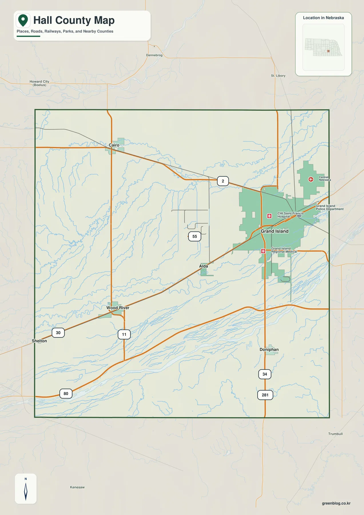
Grand Island and the Platte Valley provide the clearest road framework. U.S. 30 extends west toward Wood River, U.S. 34 crosses the southern side of Grand Island, and Interstate 80 angles across the southern county alongside the broader Platte corridor. Rail lines follow much of the same lowland transportation geography.
U.S. 281 runs south from Grand Island toward Doniphan, while Nebraska Highway 2 crosses the northern side of the city and continues toward Cairo. Highway 11 provides a north-south reference near Wood River, and Route 55 crosses part of the central rural area. These roads tie the heavily developed east to agricultural land farther west.
The road network is relatively straight across the broad river plain but becomes less regular in the higher northwest where creek valleys interrupt the rural grid. The map is useful for orientation, while current construction, closures, unpaved roads, and actual travel times should be checked with live Nebraska transportation information.
Alda is 6 miles from Grand Island, Doniphan 9, and Cairo and Wood River 14 by straight line
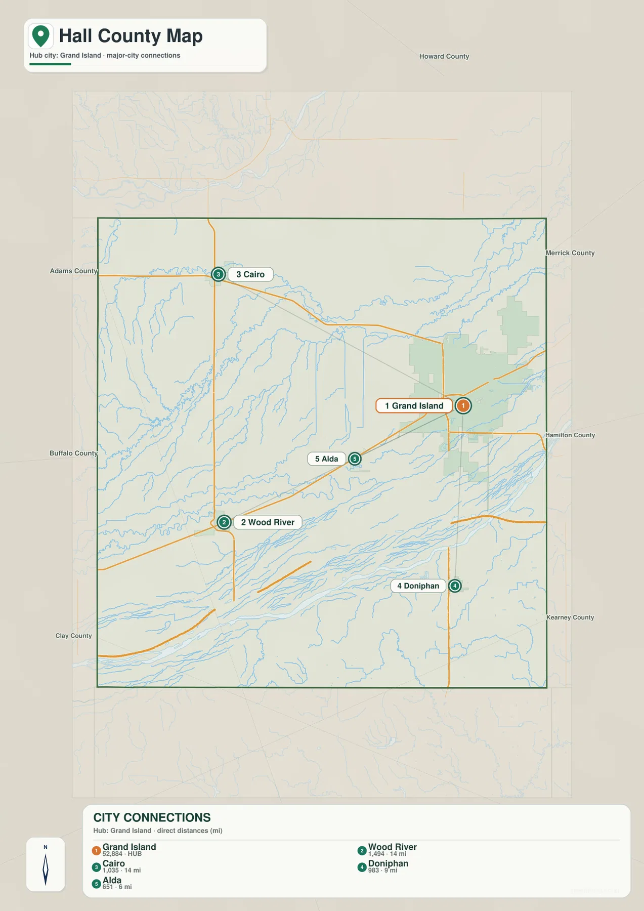
The city distribution map uses Grand Island as its hub and prints direct distances to four surrounding communities. Alda is 6 miles away, Doniphan 9 miles, and both Cairo and Wood River 14 miles. These are straight-line measurements between mapped points, not driving mileage, so road routes will generally be longer.
The directions matter as much as the numbers. Alda is immediately west of Grand Island, Doniphan lies south, Cairo is northwest, and Wood River is farther west. On the road map, Alda and Wood River relate closely to the U.S. 30 corridor, Doniphan to U.S. 281, and Cairo to Nebraska 2.
The printed ranking values are 52,884 for Grand Island, 1,494 for Wood River, 1,035 for Cairo, 983 for Doniphan, and 651 for Alda. They belong to the supplied city graphic rather than a continuously updated population table. Current official population figures should be checked with the U.S. Census Bureau or Hall County sources.
Multiple Platte channels form a wide southern lowland
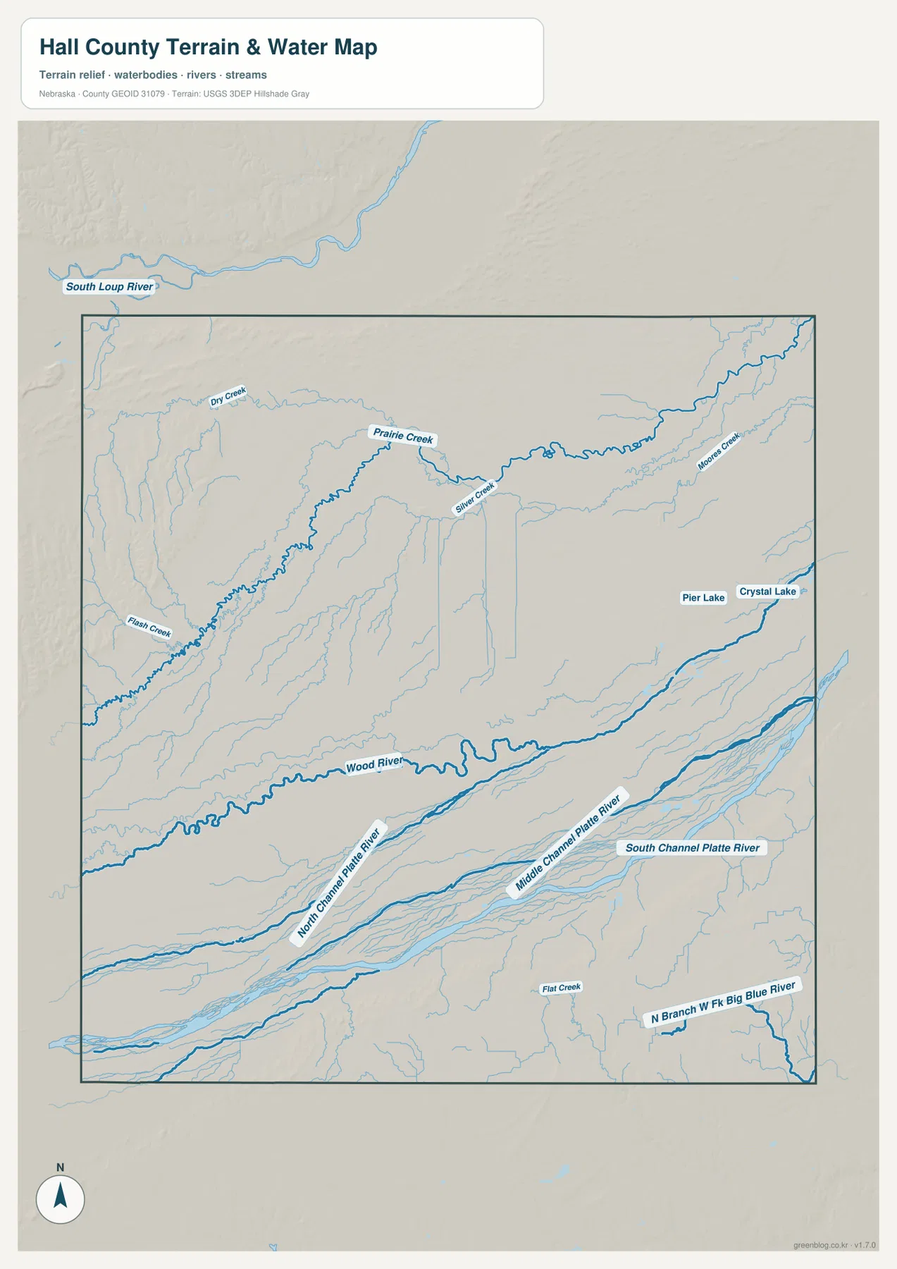
The broadest water feature is the Platte River system across the southern county. The map separately labels North Channel Platte River, Middle Channel Platte River, and South Channel Platte River, emphasizing that the river occupies a wide multi-channel corridor rather than a single narrow line. This lowland parallels much of the county’s major transportation network.
Wood River winds eastward north of the main Platte channels and approaches the Grand Island area. Prairie Creek is a major northern-interior drainage, while Silver Creek continues across the north-central and northeastern side toward Moores Creek. Dry Creek and Flash Creek add smaller branches across the western half.
Pier Lake and Crystal Lake appear east of central Grand Island, and Flat Creek lies farther southeast. North Branch West Fork Big Blue River reaches the southeastern corner, showing that the county’s drainage is not entirely directed toward the Platte system. South Loup River is visible north of the county boundary and serves only as a regional reference on this map.
This water map is intended for geographic reference. It does not define flood zones, legal water rights, parcel boundaries, present streamflow, channel depth, navigability, or public access. Those questions require current information from USGS and the responsible local or state agencies.
Western uplands rise about 113 meters above the lowest eastern and Platte lowlands
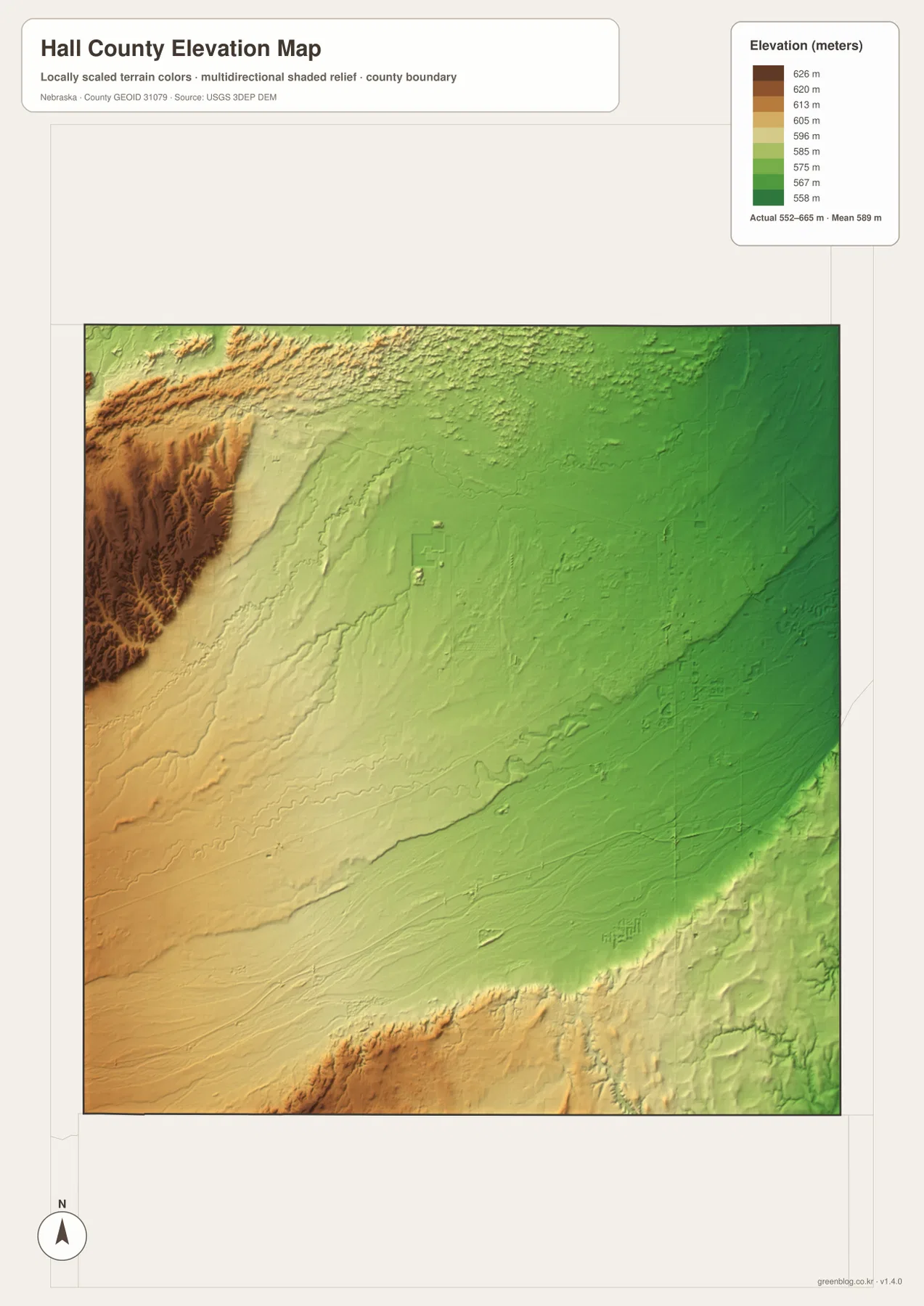
The elevation map reports an actual county-wide range of approximately 552 to 665 meters, with a mean near 589 meters. The highest orange and brown terrain is concentrated in the west and northwest, while green colors spread across the eastern half and along the river lowlands. Total mapped relief is about 113 meters.
Creeks descend from the higher western country into lower central and eastern terrain. Prairie Creek and Wood River follow parts of this general slope, and the surface becomes broader and flatter toward Grand Island. The city itself occupies relatively low terrain compared with the elevated western edge.
The Platte channels create a long low corridor across the south, although some land south of the river rises again into slightly higher terrain. Hall County therefore is not simply a smooth west-to-east ramp; it contains a low river belt bordered by higher ground and numerous shallow creek valleys.
The elevation colors are scaled locally for Hall County and should be used only for comparisons within this map. Similar colors on another county map may represent different absolute heights. The generalized surface is not survey-grade information for engineering, construction, drainage design, or property work.
The 1857 settlement grew where the Platte travel corridor and future railroad route met
Stuhr Museum says Hall County’s first permanent settlement was established in July 1857 by 32 German immigrants and five Americans. The group settled near the present Grand Island area, and expectations that a transcontinental railroad would eventually cross this part of Nebraska influenced the location.
Hall County was organized the following year. The Platte River valley already carried important westbound travel, and the Nebraska Association of County Officials notes that the Mormon Trail and later railroad expansion both helped populate the county. Grand Island Station grew with the railroad and eventually became the modern city of Grand Island.
Stuhr Museum preserves the Platte Valley’s road-ranch and railroad story
Stuhr Museum of the Prairie Pioneer stands near U.S. 34 and U.S. 281 south of central Grand Island. Its collections and historic structures interpret community building in the Platte River Valley, including farming, transportation, immigration, and an 1890s Railroad Town.
The museum’s site guide says Hall County once had eleven road ranches along emigrant routes through the Platte Valley. These stops provided provisions, repairs, and rest for travelers heading west or returning east. The modern concentration of U.S. 30, U.S. 34, Interstate 80, and rail lines in the same broad corridor shows how durable that transportation geography has been.
Use Grand Island and the Platte channels as the two easiest orientation anchors
For basic orientation, start at Grand Island and move west toward Alda and Wood River, northwest toward Cairo, and south toward Doniphan. The straight-line distances of 6, 9, and 14 miles provide a quick sense of scale before road mileage is considered.
For physical geography, begin with the Platte channels across the south, then trace Wood River northward into the interior and continue toward Prairie Creek and Silver Creek. The elevation map shows the same transition from high western terrain into lower Grand Island and Platte Valley country.
The downloadable high-resolution JPG files are useful when small highway numbers, creek names, or channel labels are difficult to read in the web previews. Starting with Grand Island’s road network and then comparing the river system with the elevation surface gives a clear overview of Hall County.
Frequently Asked Questions
Are the distances from Grand Island driving distances?
No. The map labels Alda at 6 miles, Doniphan at 9 miles, and Cairo and Wood River at 14 miles as straight-line distances from Grand Island. Actual road mileage depends on the route selected.
Where is the lowest terrain in Hall County?
The broadest low areas occur across the eastern county and along the Platte River channels in the south. The mapped elevation range is about 552 to 665 meters, while the western and northwestern terrain rises highest.
Where can visitors learn about early Hall County history?
Stuhr Museum in Grand Island interprets Hall County and Platte River Valley settlement, agriculture, immigration, road-ranch, and railroad history through collections, historic buildings, and its 1890s Railroad Town.
Map File Information
The ZIP contains the original high-resolution JPG files for the Hall County boundary and road map, city distribution map, terrain and water map, and elevation map.
- Included Files: Use only the versions confirmed in the article and supplied images
- File Type: Use the confirmed download contents
- Intended Use: Printing, education, presentations, and map-based projects
Related Maps
Sources and references
- Nebraska Association of County Officials – Hall County
- Hall County – Historical Information
- Stuhr Museum – Our Story
- Stuhr Museum – Historic Buildings and Road Ranche
- USGS National Hydrography
- USGS 3D Elevation Program
These maps are intended for geographic reference. For legal boundaries, land ownership, flood determinations, water rights, road conditions, construction, surveying, or other decisions requiring current authoritative information, consult Hall County and the responsible state or federal agency.
Green Map creates custom-edited map images using open geographic data sources such as geoBoundaries, Natural Earth, OpenStreetMap, and government open data. These maps are edited visual materials, not raw data files, and are provided for education, documents, presentations, and graphic reference.