Garfield County occupies a sparsely settled part of north-central Nebraska where Burwell sits near the lower North Loup and Calamus river country and broad Sandhills rise across the west and north. Cedar Creek and its branches cut long valleys through the interior, while only a handful of historic or rural place names appear beyond Burwell. The county map therefore emphasizes roads, streams, relief, and open country more than a network of towns. High-resolution map files are available for download in the section below.
This page explains Burwell, historic Willow Springs, the principal highways and county roads, Big Cedar Creek, Little Cedar Creek, Cedar Creek, North Loup River, small lakes, and an elevation range of about 630 to 770 meters. The original high-resolution JPG versions of the supplied maps can also be downloaded together in a ZIP for printing, classroom use, or personal reference.
Table of Contents
Burwell is the county seat and the only major incorporated community
Burwell is the Garfield County seat and the only incorporated community identified by the county’s official history. Garfield County was organized in 1884 and named for President James A. Garfield. On the map, Burwell sits close to the southwestern corner, where several highways, a rail line, and the lower river country come together.
That southwestern location is important. Highway 11, 91, and 96 converge around Burwell, while North Loup River and the Calamus drainage occupy lower ground nearby. Moving north from town, the road network thins and the terrain rises into the Sandhills, making Burwell a natural gateway between the valley and the open ranch country.
The general map also labels Willow Springs as a historical place, along with rural names such as Deverre and Gables. Willow Springs served as the early county seat, but the arrival of the railroad at Burwell shifted transportation, business, and eventually county government toward the newer town.
Highways 11, 91, and 96 provide the clearest road framework around Burwell
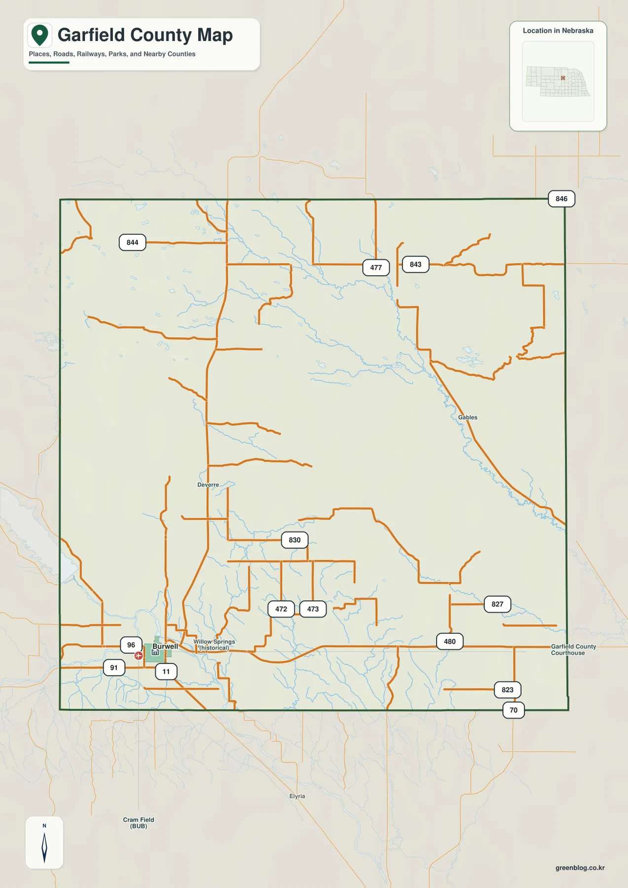
The easiest place to begin with roads is Burwell. Highway 11 provides a strong north-south reference, while 91 and 96 help organize east-west movement around town. The rail line through the Burwell-Willow Springs area also preserves the transportation pattern that helped Burwell replace Willow Springs as the county’s practical center.
Farther into the county, roads numbered 472, 473, 477, 480, 827, 830, 843, 844, and 846 cross large rural blocks. These are not urban connectors so much as access routes through ranchland and sparsely populated countryside. Near the Cedar Creek system, several roads change direction around drainage valleys rather than following a perfectly regular grid.
The difference between the southwestern corner and the rest of Garfield County is striking. Roads are relatively concentrated around Burwell, but intersections become widely spaced across the northern and western Sandhills. Current road surfaces, seasonal conditions, closures, and travel times should be checked with Nebraska transportation and local sources before driving remote county roads.
A one-city index reflects Garfield County’s unusually rural settlement pattern
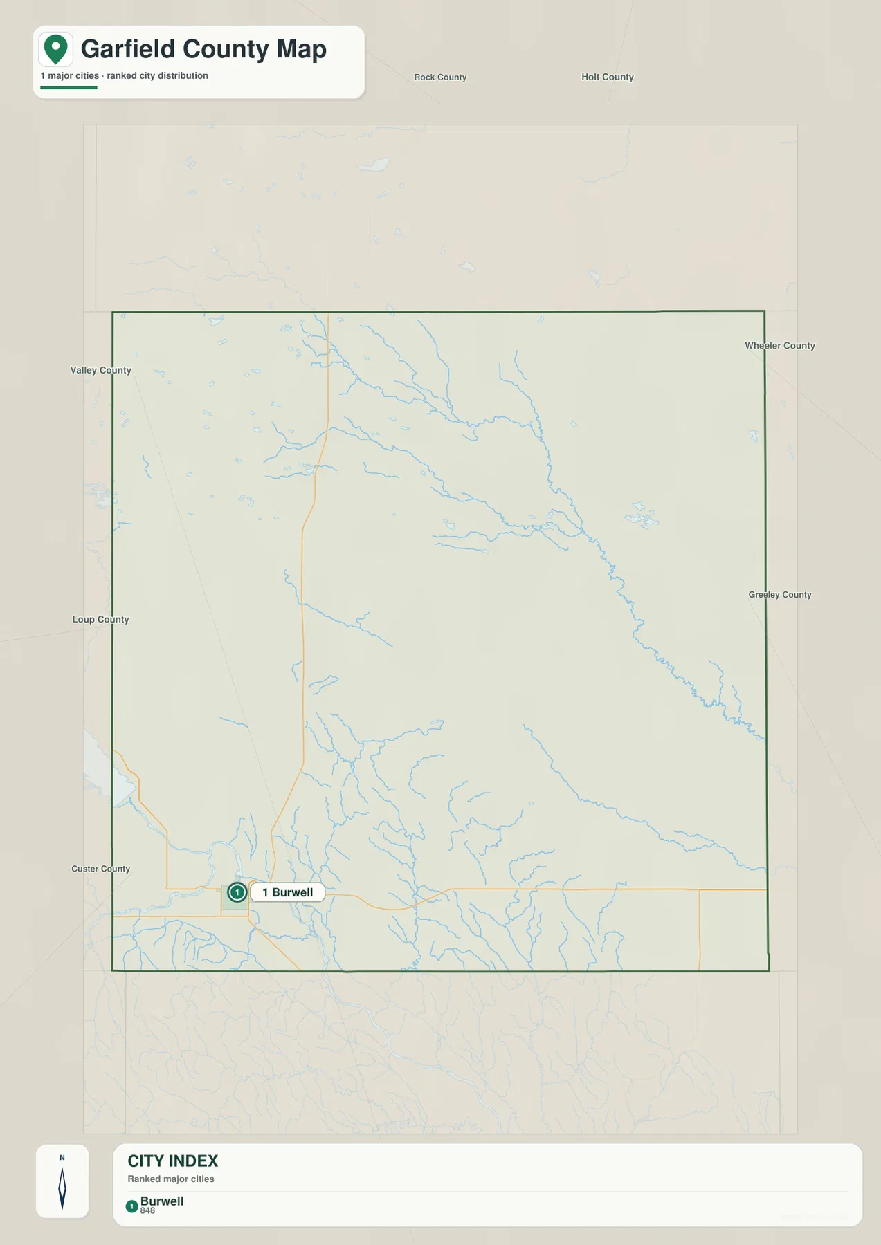
The supplied city distribution map contains only one ranked community: Burwell. Its printed value is 848, and there is no second city marker anywhere in the county. Garfield County’s own website likewise notes that Burwell is the county’s only incorporated community, making the simple city map an unusually direct picture of local settlement.
Because only one city is ranked, the map contains no connector line or mileage between communities. Burwell is better understood through its position near the southwestern road and river corridor than through city-to-city distance comparisons. Historic Willow Springs and rural place names on the general map provide more useful orientation once travelers leave town.
The value 848 belongs to the supplied ranked-city graphic rather than a continuously updated population table. Anyone needing current population counts or legal municipal status should consult the U.S. Census Bureau and current Garfield County records.
Cedar Creek branches carve long valleys through the Sandhills interior
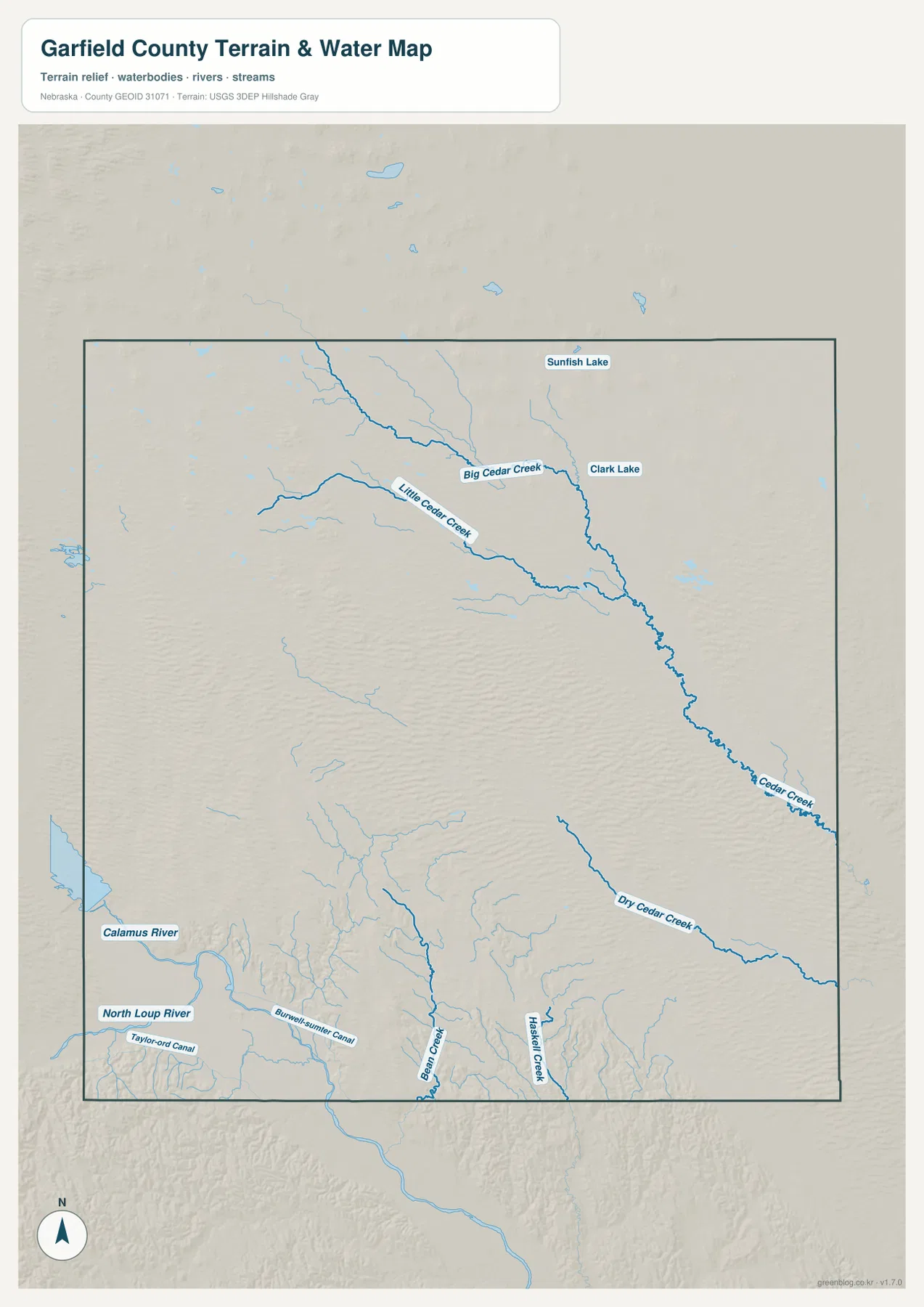
The strongest interior drainage feature is the Cedar Creek system. Big Cedar Creek and Little Cedar Creek descend from the northern half of the county and feed a longer Cedar Creek valley that trends southeastward. Dry Cedar Creek forms a separate long drainage farther south and east, dividing another section of the rolling Sandhills.
Near the southwestern corner, North Loup River and Calamus River occupy much lower ground close to Burwell. The map also labels the Burwell-Sumter Canal, showing that managed irrigation infrastructure uses the same low valley setting as the natural streams. Settlement and transportation are visibly denser in this lower corner than across the uplands.
Sunfish Lake and Clark Lake are labeled in the northern interior, with several smaller unnamed water bodies visible nearby. These features fit the broader Sandhills landscape, where low basins between dunes can hold shallow lakes or wetlands. Garfield County therefore combines large southwestern river valleys with smaller interior creeks and scattered lakes.
This water map is intended for geographic reference. It does not define flood zones, legal water rights, parcel boundaries, present streamflow, lake levels, depth, navigability, or public access. Those questions require current information from USGS and the responsible local or state agencies.
Western Sandhills rise roughly 140 meters above the lowest creek country
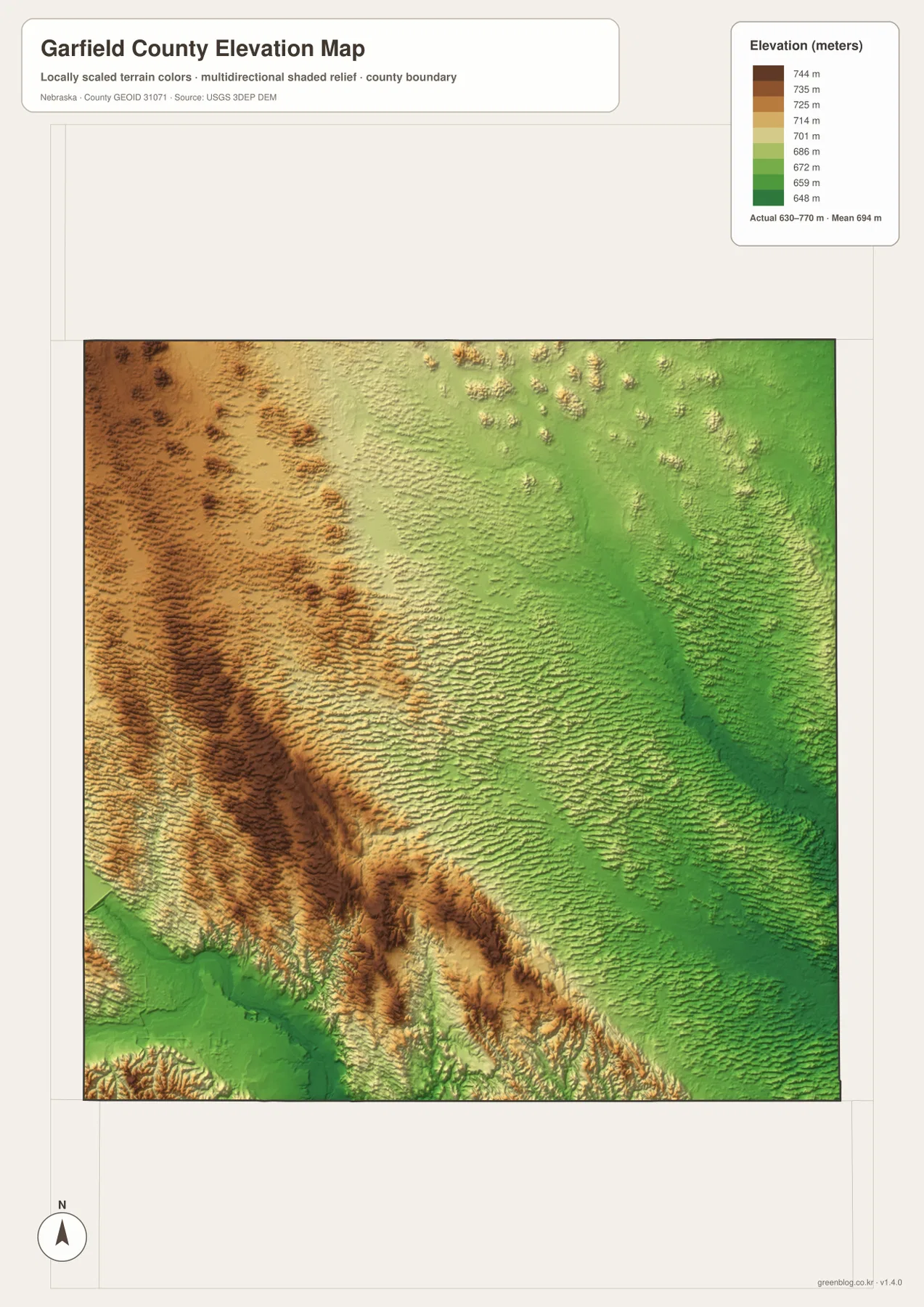
The elevation map reports an actual county-wide range of approximately 630 to 770 meters, with a mean near 694 meters. The highest brown terrain occupies much of the west and northwest, while greens become more common across central-eastern and southeastern valleys. Total mapped relief is about 140 meters.
Cedar Creek is visible as a lower corridor through the eastern half, and its Big Cedar and Little Cedar branches create narrow green valleys through higher northern ground. Dry Cedar Creek forms another long low route toward the southeast. These drainage lines explain much of the county’s visible relief.
The western Sandhills are not a smooth plateau. Closely spaced ridges and swales produce a rippled surface even where the overall elevation remains high. Toward Burwell, North Loup and Calamus river country lowers the landscape again, creating another contrast between upland dunes and valley floors.
The elevation colors are scaled locally for Garfield County and should be used to compare locations within this map. Similar shades on another county map may represent different absolute heights. The generalized surface is not survey-grade information for engineering, construction, drainage design, or property work.
Rail access shifted the county center from Willow Springs to Burwell
Garfield County’s official history says the county was organized in 1884 and that early settlement followed the North Loup and Calamus river valleys because they supplied water, timber, and practical travel routes. Willow Springs initially served as the county seat, but the transportation geography changed quickly after the railroad reached Burwell.
The Nebraska Association of County Officials says residents voted in 1890 to move the county seat to Burwell. Railroad access, the river valley, and nearby farmland made Burwell more attractive to residents and businesses, while Willow Springs gradually declined. The supplied road map preserves that history by showing Burwell as the dense southwestern center and Willow Springs only as a historical place.
Nebraska’s Big Rodeo grew from Burwell’s ranching heritage
Burwell is also known for Nebraska’s Big Rodeo. The event’s official history says local residents created the first rodeo in 1921 to celebrate western heritage and provide a major community gathering. It became an annual tradition and has drawn competitors and spectators to the Garfield County Fairgrounds for more than a century.
The rodeo fits the landscape shown by these maps. Garfield County’s official profile describes agriculture and ranching as long-standing foundations of the local economy, and the sparse city pattern, long rural roads, and broad Sandhills uplands all reinforce that rural identity. The maps are not land-use maps, but they make the county’s low settlement density unmistakable.
Use Burwell and Cedar Creek as two practical map anchors
For basic orientation, locate Burwell in the southwest and identify Highways 11, 91, and 96. Then move north and east along roads such as 472, 473, 477, and 480 to understand how the sparse interior is connected. Willow Springs and Deverre provide additional reference points where towns are otherwise absent.
For physical geography, trace Cedar Creek northwest toward Big Cedar and Little Cedar creeks, then compare those valleys with North Loup and Calamus river country near Burwell. The elevation map shows the same contrast as high western Sandhills fall into lower green drainage corridors.
The downloadable high-resolution JPG files are useful when county-road numbers, creek names, or small lake labels are difficult to read in the web previews. Starting with Burwell and then comparing the Cedar Creek network with the elevation surface provides a clear way to understand the county without turning the page into a simple map inventory.
Frequently Asked Questions
Why does the city map show only Burwell?
Garfield County’s official profile says Burwell is the county’s only incorporated community. The supplied city graphic reflects that settlement pattern by ranking only Burwell and showing no connector lines or mileage to another major city.
Where is the highest terrain in Garfield County?
The highest terrain is concentrated across the west and northwest Sandhills. The mapped elevation range is about 630 to 770 meters, while Cedar Creek and southeastern drainage valleys sit noticeably lower.
Was Willow Springs once the county seat?
Yes. Willow Springs was the early county seat, but railroad access shifted business and population toward Burwell. County voters moved the seat to Burwell in 1890, and Willow Springs now appears on the map as a historical place.
Map File Information
The ZIP contains the original high-resolution JPG files for the Garfield County boundary and road map, city distribution map, terrain and water map, and elevation map.
- Included Files: Use only the versions confirmed in the article and supplied images
- File Type: Use the confirmed download contents
- Intended Use: Printing, education, presentations, and map-based projects
Related Maps
Sources and references
- Garfield County – About Our County
- Nebraska Association of County Officials – Garfield County
- Nebraska’s Big Rodeo – History
- U.S. Census Bureau TIGER/Line Shapefiles
- USGS National Hydrography
- USGS 3D Elevation Program
These maps are intended for geographic reference. For legal boundaries, land ownership, flood determinations, water rights, road conditions, construction, surveying, or other decisions requiring current authoritative information, consult Garfield County and the responsible state or federal agency.
Green Map creates custom-edited map images using open geographic data sources such as geoBoundaries, Natural Earth, OpenStreetMap, and government open data. These maps are edited visual materials, not raw data files, and are provided for education, documents, presentations, and graphic reference.