Gage County occupies a deeply drained part of southeastern Nebraska, with Beatrice in the Big Blue River valley and smaller communities spread across rolling agricultural uplands. Wymore and Blue Springs sit to the south, while Adams, Cortland, and Clatonia mark the northern half. The Big Blue corridor is distinctly lower than surrounding ridges, and tributaries such as Indian, Bear, Cedar, and Mud creeks divide the uplands into a dense pattern of valleys. High-resolution map files are available for download in the section below.
This page explains the positions of Beatrice, Wymore, Adams, Cortland, Blue Springs, and Clatonia, the main highway network, Big Blue River and its tributaries, Rockford Lake and smaller lakes, and an elevation range of about 354 to 470 meters. The original high-resolution JPG versions of the supplied maps can also be downloaded together in a ZIP for printing, classroom use, or personal reference.
Table of Contents
Beatrice anchors the county where roads meet the Big Blue valley
Beatrice is the Gage County seat and the dominant community on the supplied maps. The Nebraska Association of County Officials says Gage County was authorized in 1855, organized in 1857, and named for William Gage, an early territorial legislative chaplain. Beatrice sits slightly south of the county’s midpoint but occupies a practical location where the Big Blue River and several important roads converge.
Pickrell and Cortland lie north of Beatrice, while Clatonia is farther northwest. Blue Springs and Wymore occupy the southern portion, and Filley appears to the east. This produces a dispersed settlement pattern rather than a single continuous urban strip, with towns connected by river valleys, rail lines, and state highways.
History Nebraska records that members of the Nebraska Association selected a townsite in Gage County near the Big Blue River in 1857. The name Beatrice was officially chosen on May 5 of that year. The modern map still shows why the site proved useful: low ground, water, roads, and later rail connections all meet in the same central-southern area.
U.S. 77 and U.S. 136 make Beatrice the clearest highway reference
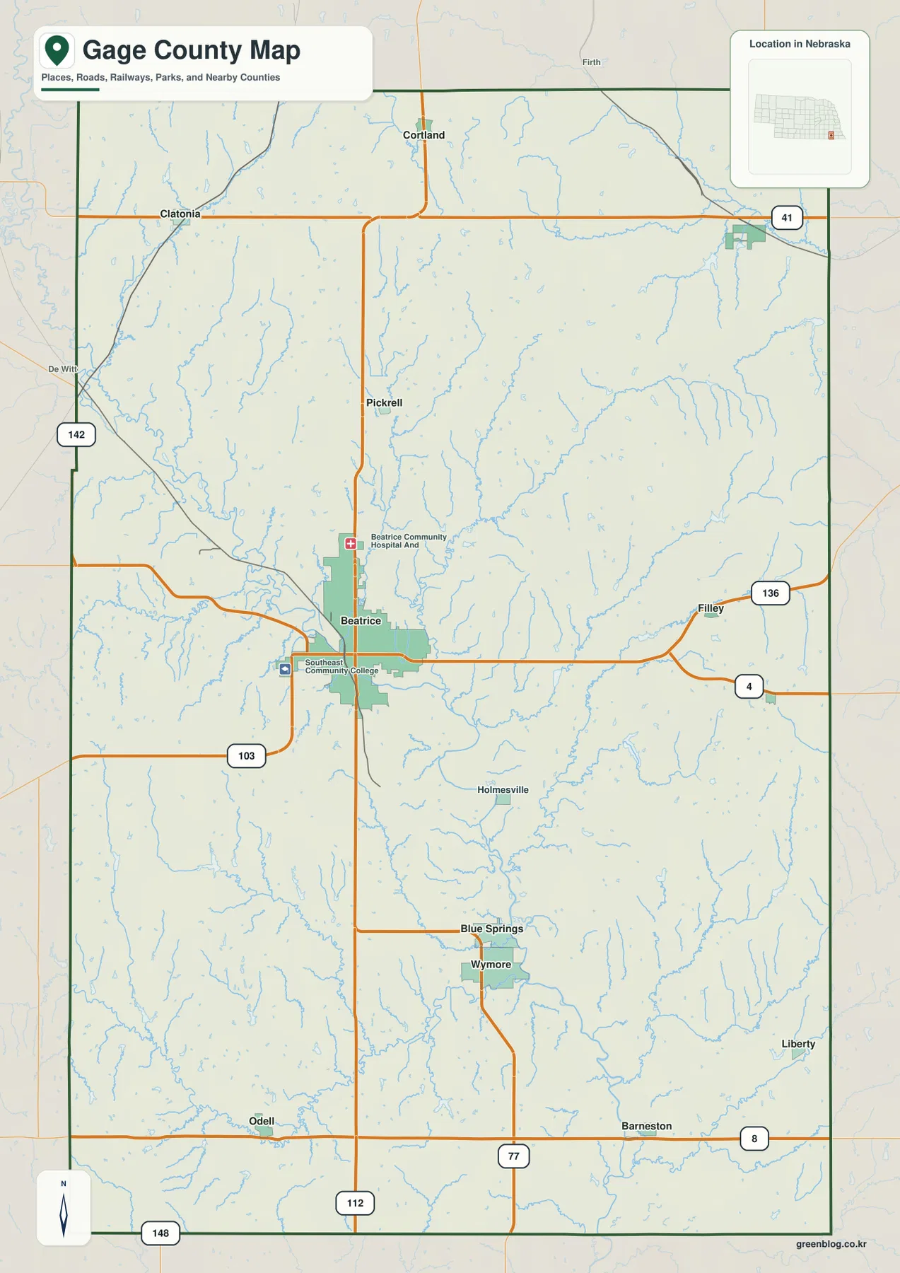
U.S. 77 is the strongest north-south road on the map, crossing Beatrice and continuing toward Wymore. U.S. 136 runs east-west through Beatrice toward Filley, while Nebraska Highway 4 branches southeast into the eastern countryside. Together these routes organize the county’s central and southern travel pattern.
Highway 41 crosses the northern part of the county near Cortland and the Adams area. Route 142 enters from the west, Route 103 serves the southwest side of Beatrice, and Route 112 runs south through the central county. Near the southern boundary, Routes 8 and 148 help locate Barneston, Odell, and the Kansas-border countryside.
Roads are relatively continuous in the low Big Blue corridor, but smaller local routes bend more often across the northern and eastern hills where tributary valleys interrupt the rural grid. The county map is useful for orientation, while construction, closures, unpaved roads, and actual travel times should be checked with current Nebraska transportation information.
Six ranked communities span both the Big Blue corridor and the northern uplands
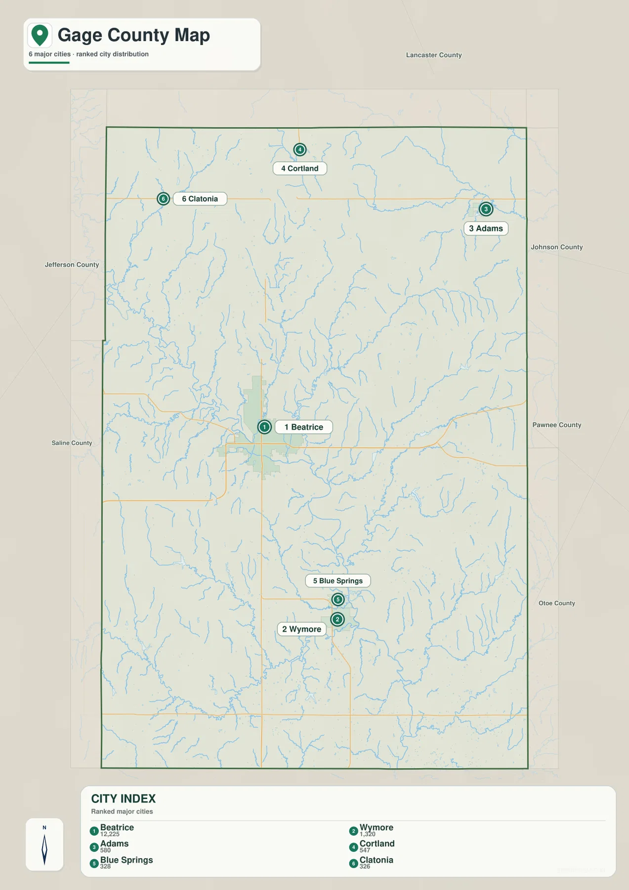
The city distribution map ranks Beatrice first, followed by Wymore, Adams, Cortland, Blue Springs, and Clatonia. Beatrice occupies the central-southern valley, Wymore and Blue Springs are farther south, Adams lies northeast, Cortland north-central, and Clatonia northwest. The six markers therefore cover much of the county rather than clustering in one small corner.
No connector lines or mileage labels appear on the supplied city map. The useful comparison is positional rather than numerical. Pairing the city view with the general road map makes it easier to understand how Wymore and Blue Springs relate to U.S. 77 and how Adams, Cortland, and Clatonia occupy the higher northern countryside.
The values printed on the supplied city graphic are 12,225 for Beatrice, 1,320 for Wymore, 580 for Adams, 547 for Cortland, 328 for Blue Springs, and 326 for Clatonia. They belong to the supplied ranking and should not be treated as a continuously updated population table. Current figures should be checked with the U.S. Census Bureau or local official sources when needed.
Big Blue River forms the main low corridor through a dense tributary network
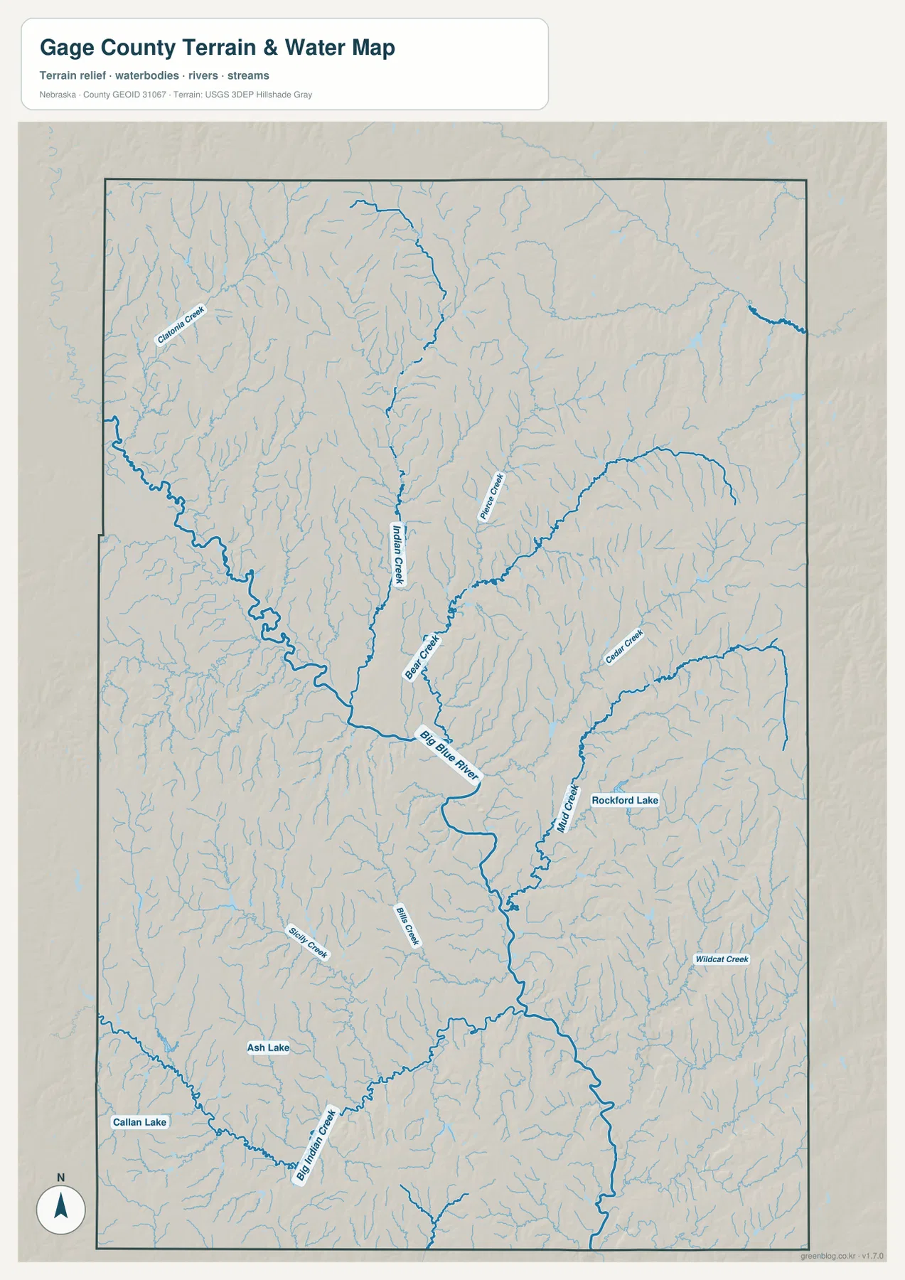
Big Blue River is the county’s dominant water feature and winds south through the central interior. Its valley broadens near Beatrice, where several tributaries converge. Indian Creek and Bear Creek join the central drainage, while a larger western tributary reaches the Big Blue from the northwest.
Clatonia Creek and Turkey Creek appear across the north, and Cedar Creek cuts a pronounced valley through the eastern uplands. Mud Creek crosses the southeast-central side near Rockford Lake, while Wildcat Creek appears farther southeast. Big Indian Creek and Sicily Creek create additional lower corridors across the southwest.
The map also labels Rockford Lake, Ash Lake, and Callan Lake. Nebraska Game and Parks describes Rockford Lake State Recreation Area, east of Beatrice, as a roughly 150-acre lake surrounded by recreation land. The supplied water map is still only a geographic reference: flood risk, legal water rights, parcel boundaries, lake levels, depth, and access require current authoritative information.
The Big Blue valley sits more than 100 meters below the county’s highest ridges
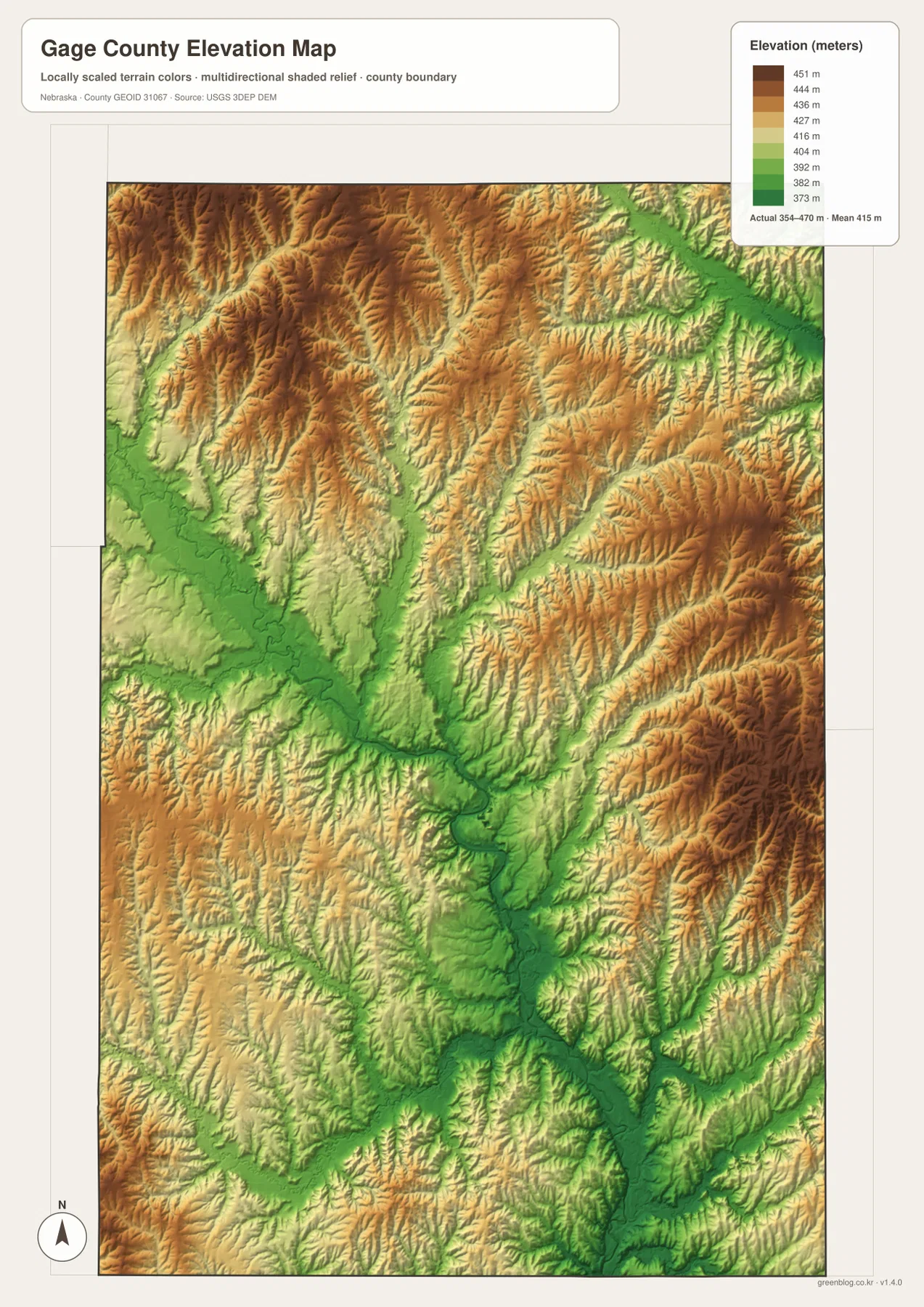
The elevation map reports an actual county-wide range of approximately 354 to 470 meters, with a mean near 415 meters. The lowest dark-green terrain follows Big Blue River through the middle and southern county. Beatrice lies within this lower corridor, and many tributary valleys extend away from it as narrow green branches.
Higher brown terrain covers much of the north and northwest, with additional high ridges across the east and southeast. Cedar Creek and Mud Creek are particularly useful examples: their channel bottoms are low, but the adjacent ridges rise quickly on both sides. Total mapped relief is about 116 meters.
Indian Creek, Bear Creek, and Big Indian Creek create additional low routes through higher farmland before joining the main river system. The southern county contains some broader lower surfaces, but numerous smaller tributaries still prevent the landscape from becoming uniformly flat.
The elevation colors are scaled locally for Gage County and should be used to compare places within this map. Similar shades on another county map may represent different absolute heights. The generalized surface is not survey-grade information for engineering, construction, drainage design, or property work.
Beatrice was founded beside the Big Blue River in 1857
History Nebraska traces Beatrice to the Nebraska Association, a group formed by settlers traveling up the Missouri River in 1857. After exploring southeastern Nebraska, the group selected a site near the center of Gage County along the Big Blue River. The name Beatrice was adopted on May 5, 1857.
The Nebraska Association of County Officials notes that Blue Springs later challenged Beatrice for the county seat, but the territorial legislature confirmed Beatrice in 1859. The present map shows that Beatrice’s location combines a river valley, multiple road approaches, and room for urban growth, helping explain why it remained the county’s dominant center.
Homestead National Historical Park connects local farmland with a national story
Homestead National Historical Park lies west of Beatrice on land associated with Daniel Freeman’s homestead claim. The National Park Service says Freeman filed his claim on January 1, 1863, the first day the Homestead Act was in effect, and the site later became a national memorial to the broader homesteading experience.
The park was established in 1936 and interprets the Homestead Act’s nationwide consequences. Its location in Gage County provides a direct link between the county’s modern agricultural landscape and the nineteenth-century land policies that shaped settlement across much of the Great Plains.
Use Beatrice and Big Blue River as the two easiest map anchors
For basic orientation, start at Beatrice and follow U.S. 77 north toward Cortland or south toward Blue Springs and Wymore. U.S. 136 leads east toward Filley, while Highway 41 provides a northern reference for the Adams area. The ranked city map offers a simpler view when minor roads are not needed.
For physical geography, trace Big Blue River first and then follow Indian, Bear, Cedar, and Mud creeks into the surrounding uplands. The elevation map explains the same pattern with a low green central corridor and higher brown ridges to the north and east.
The high-resolution JPG files are useful when small road labels, creek names, and lake labels are difficult to read in the web previews. Start with Beatrice and the Big Blue corridor, then compare the tributary valleys with the elevation surface; that sequence makes the contrast between the low central valley and the surrounding uplands easier to follow without turning the page into a map-by-map checklist.
Frequently Asked Questions
Does the city map show distances from Beatrice to Wymore or Adams?
No. The supplied city map ranks and locates Beatrice, Wymore, Adams, Cortland, Blue Springs, and Clatonia, but it does not include connector lines or mileage. Use the road map for relative position and a current routing service when actual driving distance is needed.
Where is the lowest terrain in Gage County?
The Big Blue River valley through the central and southern county contains the lowest broad terrain. The mapped elevation range is about 354 to 470 meters, with higher ridges across much of the north and parts of the east and west. Tributary valleys remain locally lower than the surrounding farmland.
Is there a nationally significant historic site near Beatrice?
Yes. Homestead National Historical Park lies west of Beatrice and commemorates the Homestead Act and the Daniel Freeman claim associated with the Act’s first day. The county map is not a park navigation map, so current access and visitor information should be checked with the National Park Service.
Map File Information
The ZIP contains the original high-resolution JPG files for the Gage County boundary and road map, city distribution map, terrain and water map, and elevation map.
- Included Files: Use only the versions confirmed in the article and supplied images
- File Type: Use the confirmed download contents
- Intended Use: Printing, education, presentations, and map-based projects
Related Maps
Sources and references
- Nebraska Association of County Officials – Gage County
- History Nebraska – The Naming of Beatrice
- National Park Service – Homestead National Historical Park
- Nebraska Game and Parks – Rockford Lake
- U.S. Census Bureau TIGER/Line Shapefiles
- USGS 3D Elevation Program
These maps are intended for geographic reference. For legal boundaries, land ownership, flood determinations, water rights, road conditions, construction, surveying, or other decisions requiring current authoritative information, consult Gage County and the responsible state or federal agency.
Green Map creates custom-edited map images using open geographic data sources such as geoBoundaries, Natural Earth, OpenStreetMap, and government open data. These maps are edited visual materials, not raw data files, and are provided for education, documents, presentations, and graphic reference.