Cass County occupies the southeastern edge of the Omaha-Lincoln corridor, with Plattsmouth at the meeting point of two major river landscapes. The Platte River forms much of the northern boundary, the Missouri River defines the east, and a dense network of creeks cuts through higher rolling ground to the west and southwest. Louisville, Weeping Water, Eagle, Elmwood, and Greenwood provide useful interior reference points beyond the county seat. High-resolution map files are available for download in the section below.
This page explains the county boundary and road network, the distribution of six major communities, the Platte and Missouri river edges, Weeping Water Creek and other waterways, and an elevation range of roughly 282 to 418 meters. The original high-resolution JPG versions of the supplied maps are also available together in a ZIP for printing, classroom use, or personal reference.
Table of Contents
Plattsmouth anchors the county where two major river corridors come together
Plattsmouth is the Cass County seat and the easiest place to start reading the map. The official county website identifies Plattsmouth as the administrative center and lists Alvo, Avoca, Cedar Creek, Eagle, Elmwood, Greenwood, Louisville, Manley, Murdock, Murray, Nehawka, South Bend, Union, and Weeping Water among the county’s communities. On the map, Plattsmouth stands out in the northeast near the Missouri River and not far below the mouth of the Platte.
Sarpy County lies north across the Platte, while Saunders and Lancaster Counties are west and Otoe County is south. The Missouri River forms the eastern boundary opposite Iowa. The county’s northern and eastern edges therefore follow major rivers, while much of the west and south is defined by straighter survey boundaries.
History Nebraska describes Cass County as one of the early counties organized in Nebraska Territory and records Plattsmouth as the county seat from the beginning of county government. Trading and ferry activity along the Missouri preceded formal organization, giving the northeastern river edge an important role in the county’s earliest settlement history.
U.S. 75, Route 66, and the central roads connect the river edge with the interior
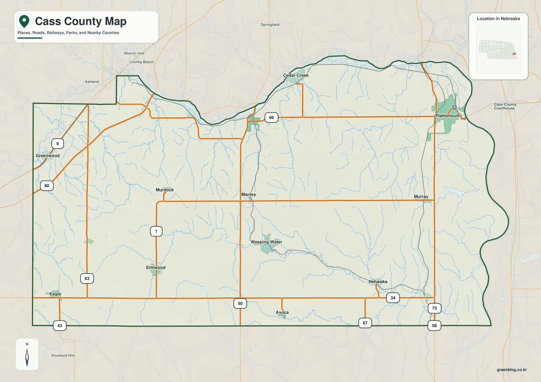
U.S. 75 is the strongest north-south road reference on the eastern side. It passes through Plattsmouth and continues south toward Murray and Nehawka, where routes 34, 58, and 67 provide additional connections. Route 66 runs west from the Plattsmouth side toward Louisville, giving the northern interior a clear east-west line.
Route 50 crosses the central county north to south, while Route 1 serves the Murdock and Elmwood area. Route 34 forms another long east-west reference across the south, with routes 63 and 43 appearing farther west. U.S. 6 and Interstate 80 are visible near the northwest edge, showing how Cass County connects with the larger transportation network between Omaha and Lincoln.
The road pattern becomes more irregular away from the broad river lowlands. Numerous creeks and short valleys cut the central and southern uplands, so local roads often follow terrain rather than a perfectly uniform grid. The map is useful for overall orientation, but current construction, closures, road surfaces, and travel times should be checked with live transportation information.
Six ranked communities stretch from Plattsmouth to Greenwood and Eagle
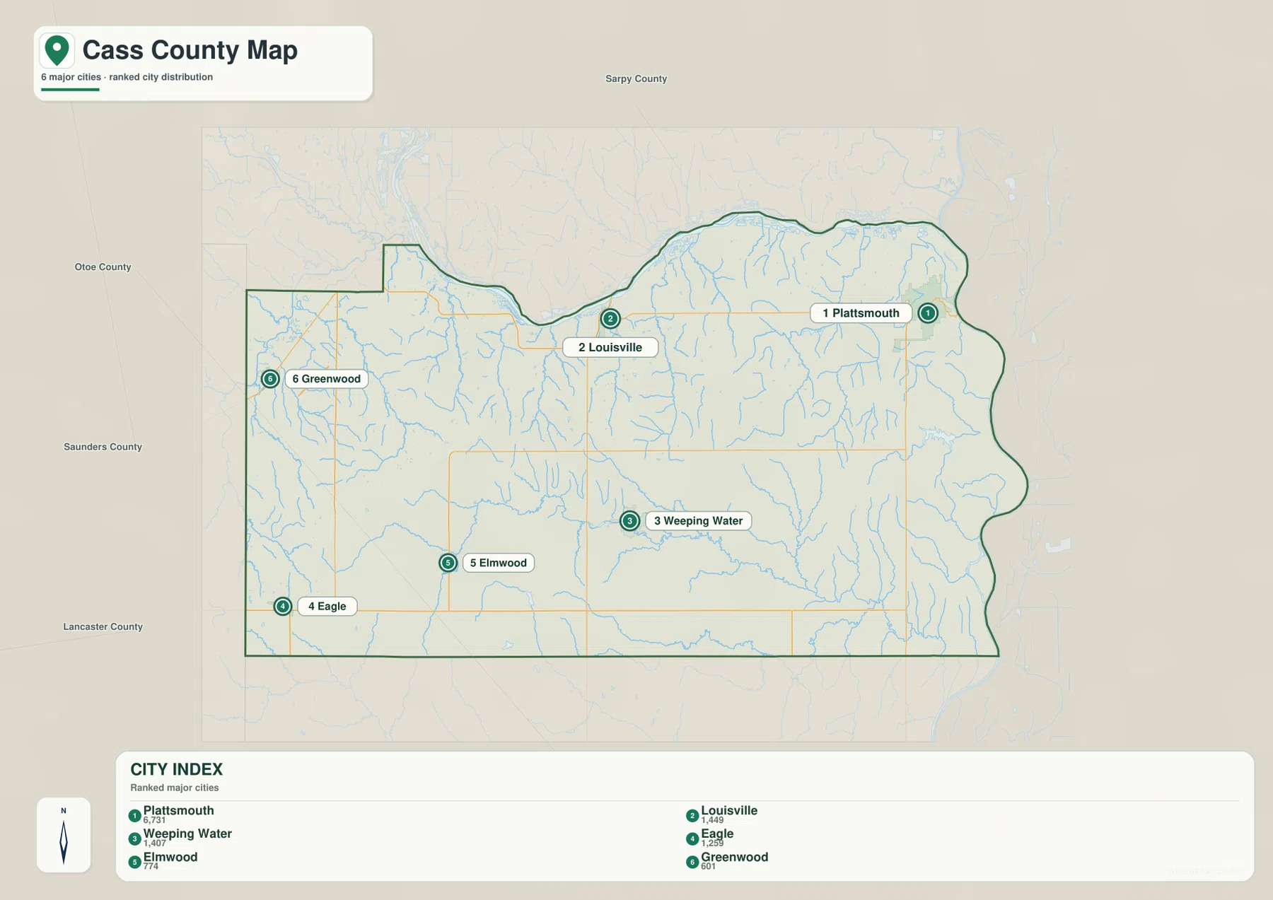
The city map ranks Plattsmouth first, followed by Louisville, Weeping Water, Eagle, Elmwood, and Greenwood. Plattsmouth is northeast, Louisville is north-central, Weeping Water lies in the central-southern interior, and Eagle, Elmwood, and Greenwood occupy the west and southwest. The six markers show a county whose larger communities are spread across several different terrain settings.
No connector lines or mileage labels appear between these communities on the supplied map. The useful comparison is therefore positional rather than numerical. The general road map is the better source when practical travel relationships matter, while the city view makes settlement distribution easier to compare at a glance.
The official county website lists additional places such as Cedar Creek, Manley, Murdock, Murray, Nehawka, Avoca, and Union. The city map is therefore a ranked summary of six major communities rather than a complete inventory of every incorporated or named place in Cass County.
The Platte and Missouri frame a dense interior drainage network
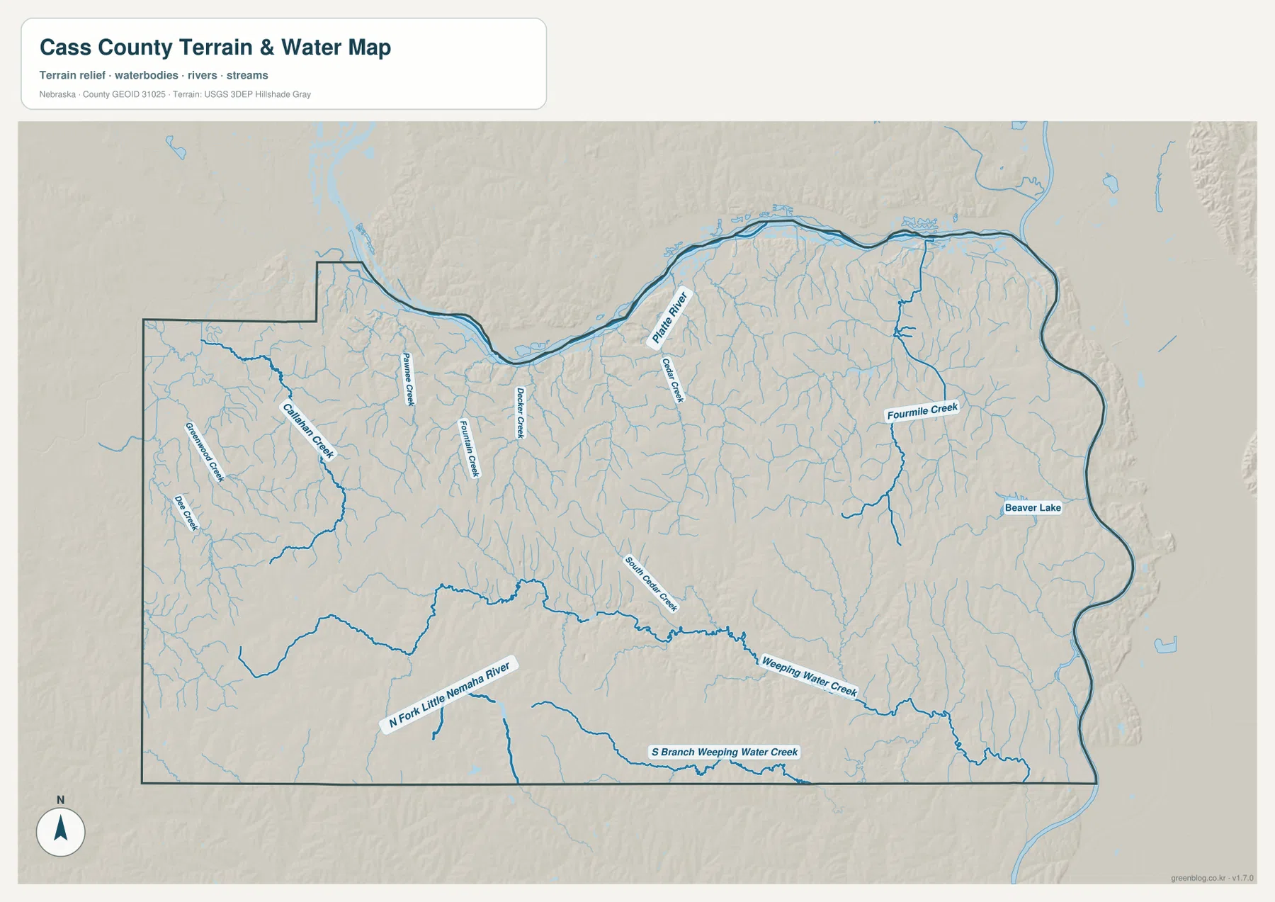
The Platte River is the defining water feature along the northern boundary. It bends eastward toward the Missouri River near the Plattsmouth area, while the Missouri continues south along the county’s eastern edge. These two large rivers create broad lowlands that contrast sharply with the more deeply dissected interior.
Cedar Creek drains the northern interior toward the Platte, and Fourmile Creek is prominent in the east-central section. Beaver Lake provides a recognizable standing-water feature south of Plattsmouth. Many smaller tributaries branch away from these named streams, producing a dense network of short valleys across the eastern half.
Weeping Water Creek is the strongest interior east-west drainage. It crosses the central-southern part of the county and is joined by South Branch Weeping Water Creek. Farther southwest, North Fork Little Nemaha River occupies another long valley. Together these waterways show that the interior is structured by multiple creek systems rather than by a single dominant river.
This map is intended for geographic reference. It does not define flood zones, legal water rights, parcel boundaries, channel depth, navigability, or public access. Those questions require current information from USGS and the appropriate local or state agencies.
Elevation rises from the river lowlands into the western and southwestern hills
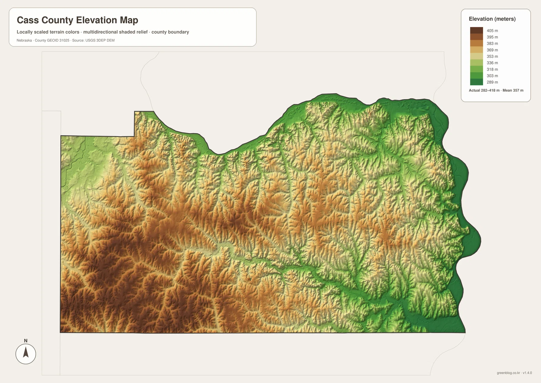
The elevation map reports an actual county-wide range of approximately 282 to 418 meters, with a mean near 357 meters. The lowest green terrain follows the Platte River across the north and the Missouri River along the east. Plattsmouth lies close to this low river country rather than within the higher western interior.
Elevation increases toward the west and southwest, where tan and brown uplands are cut by a dense pattern of short valleys. The total difference is only about 136 meters, but the terrain looks strongly textured because the ridges and creek bottoms repeat at close intervals. The west-central interior contains some of the highest and most dissected ground on the map.
Weeping Water Creek forms a long green corridor across the higher interior, and Fourmile Creek creates another lower route farther east. North Fork Little Nemaha River is also visible as a low valley in the southwest. The relationship between water and relief becomes especially clear when the water and elevation maps are viewed together.
The colors are scaled locally for Cass County and should be used to compare places within this map. Similar shades on another county map may represent different absolute elevations. The generalized surface is not survey-grade data for engineering, construction, drainage design, or property work.
Plattsmouth grew at a strategic river location
History Nebraska records that early settlement and trade in Cass County were closely tied to the Missouri River. Plattsmouth developed on the west bank of the Missouri only a short distance below the mouth of the Platte, and it became the county seat during the territorial period. Ferries and trading posts preceded many later roads and rail lines.
The official county profile still describes Cass County as bounded by the Platte on the north and the Missouri on the east. The modern map therefore reflects the same basic geography that influenced early settlement: Plattsmouth occupies the river edge, while communities farther west sit among higher agricultural uplands and creek valleys.
Weeping Water Creek provides a useful line through the interior hills
Weeping Water Creek is one of the easiest features to use when organizing the county’s interior. The community of Weeping Water lies close to the drainage, and the creek cuts eastward through terrain that is much higher than the Platte and Missouri lowlands. On the elevation map, its valley appears as a long lower corridor through the rolling uplands.
Louisville and Cedar Creek lie closer to the Platte River side, while Eagle, Elmwood, and Greenwood occupy higher western and southwestern terrain. Moving west from Plattsmouth therefore means leaving the broad river lowlands and entering a landscape of more pronounced ridges and creek valleys.
Using the four Cass County map views together
For basic orientation, start with Plattsmouth and U.S. 75, then move west toward Louisville and south toward Murray and Nehawka. Weeping Water provides a central interior reference, while Elmwood, Eagle, and Greenwood help define the western side. Routes 66, 50, 34, and 1 make those relationships easier to follow.
For physical geography, begin with the Platte and Missouri rivers, then trace Cedar Creek and Fourmile Creek before following Weeping Water Creek and North Fork Little Nemaha River through the interior. The elevation map explains why the eastern and northern river edges are low while the west and southwest contain higher rolling ground.
For printing or classroom display, the downloadable high-resolution JPG files preserve more road labels and creek names than the web previews. The county map emphasizes roads and boundaries, the city map summarizes major communities, the water map identifies rivers and creeks, and the elevation map highlights the contrast between river lowlands and western uplands.
Frequently Asked Questions
Does the city map show distances from Plattsmouth to the other communities?
No. The supplied city map ranks and locates Plattsmouth, Louisville, Weeping Water, Eagle, Elmwood, and Greenwood, but it does not include connector lines or mileage. Use the general road map for relative position and a current routing service when actual driving distance is needed.
Where is the lowest terrain in Cass County?
The broad Platte River corridor in the north and the Missouri River edge in the east contain the lowest terrain. The county-wide elevation range is about 282 to 418 meters, while higher rolling ground becomes more common toward the west and southwest.
Can the water map be used for flood or property decisions?
No. It is a geographic reference showing the Platte and Missouri rivers, Weeping Water Creek, Fourmile Creek, North Fork Little Nemaha River, Beaver Lake, and smaller tributaries. Flood risk, water rights, parcel boundaries, access, and channel conditions require current authoritative records.
Map File Information
The ZIP contains the original high-resolution JPG files for the Cass County boundary and road map, city distribution map, terrain and water map, and elevation map.
- Included Files: Use only the versions confirmed in the article and supplied images
- File Type: Use the confirmed download contents
- Intended Use: Printing, education, presentations, and map-based projects
Related Maps
Sources and references
- Cass County – About Cass County
- History Nebraska – Cass County Historical Note
- U.S. Census Bureau TIGER/Line Shapefiles
- USGS National Hydrography
- USGS 3D Elevation Program
These maps are intended for geographic reference. For legal boundaries, land ownership, flood determinations, water rights, road conditions, construction, surveying, or other decisions requiring current authoritative information, consult Cass County and the responsible state or federal agency.
Green Map creates custom-edited map images using open geographic data sources such as geoBoundaries, Natural Earth, OpenStreetMap, and government open data. These maps are edited visual materials, not raw data files, and are provided for education, documents, presentations, and graphic reference.