Burt County occupies a narrow section of northeastern Nebraska between rolling agricultural country and the Missouri River. Tekamah, the county seat, sits in the east-central part of the county, with Decatur to the north, Oakland and Lyons farther west, and Craig southwest of Tekamah. The eastern boundary bends repeatedly with the Missouri River, while the western side is much straighter and higher. High-resolution map files are available for download in the section below.
This page follows the county road network, the straight-line city connections from Tekamah, the Missouri River lowlands and interior creeks, and the elevation change into the central and western hills. The original high-resolution JPG versions of the supplied maps can also be downloaded together in a ZIP for printing, classroom use, or personal reference.
Table of Contents
Tekamah and the Missouri River give Burt County its clearest orientation
Tekamah is the county seat and the easiest place to begin reading the map. Burt County’s official profile identifies Tekamah as the county seat and largest city, with Oakland, Lyons, Decatur, and Craig among the other principal communities. On the supplied map, Tekamah stands out near the eastern side where the uplands descend toward the Missouri River plain.
Thurston County lies to the north, Cuming and Dodge Counties are west, and Washington County is south. The Missouri River forms the eastern edge opposite Iowa. Around Decatur and east of Tekamah, the boundary follows large river bends rather than a straight survey line, making the natural geography unusually important to the county’s shape.
Burt County’s official history says the county was founded in 1854 and named for Francis Burt, the first governor of Nebraska Territory. History Nebraska likewise identifies it as one of the original eight counties created by the territorial legislature. Tekamah was also laid out in 1854, so the history of the county and its present seat began at nearly the same time.
U.S. 75 near Tekamah contrasts with the rural roads farther west
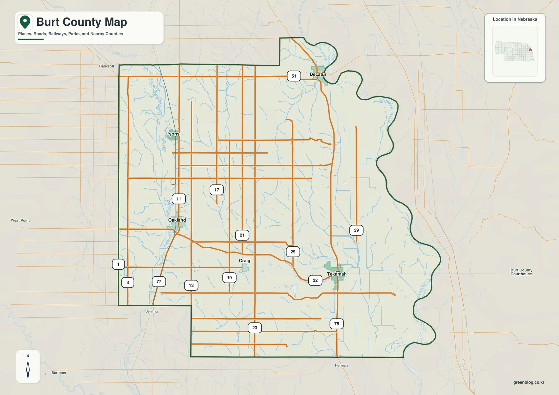
U.S. 75 is the easiest north-south road reference near Tekamah. It follows the eastern side of the county through the broad Missouri lowland, while Route 51 is visible near Decatur farther north. Route 32 extends westward from the Tekamah area into the county interior.
Oakland sits in the west-central part of the county near the road marked 11, with Lyons farther north. Around Craig and the south-central interior, routes marked 19, 21, and 29 provide additional rural connections. Roads 1, 3, and 77 appear closer to the western boundary, linking the county with the wider road network in Cuming and Dodge Counties.
The road pattern changes across the county. The eastern lowland has long, comparatively direct routes near the Missouri River, while the central and western parts contain more short stream valleys and rolling hills. The general map is useful for orientation, but current construction, closures, road surfaces, and driving time should be checked with live transportation information.
Tekamah is the hub for four straight-line city connections
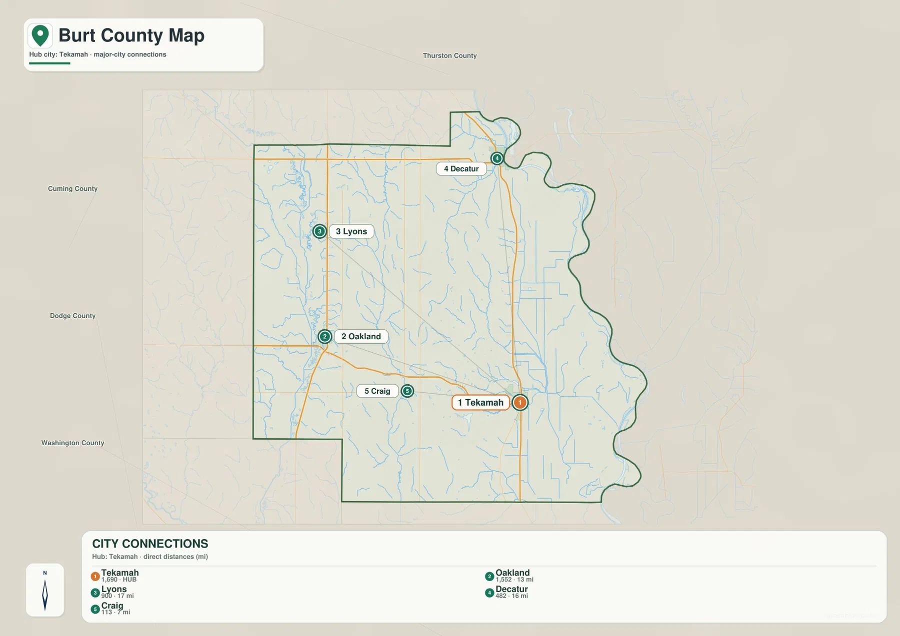
The city-connection map uses Tekamah as the hub. It shows approximately 7 straight-line miles from Tekamah to Craig, 13 miles to Oakland, 16 miles to Decatur, and 17 miles to Lyons. These are direct point-to-point measurements rather than road mileage, so actual driving distances will depend on the route used.
Oakland and Lyons are west and northwest of Tekamah, Decatur is north, and Craig is west-southwest. The four connections spread in different directions instead of forming a single corridor. That arrangement is useful for understanding why an eastern county seat can still function as the center for communities distributed across the interior.
The map ranks Tekamah first, Oakland second, Lyons third, Decatur fourth, and Craig fifth. Burt County’s official 2020 population figures show the same broad size order, with Tekamah the largest community. The graphic therefore works well as a compact settlement summary while the road map supplies the practical transportation context.
Missouri bottomlands meet a dense network of interior creeks
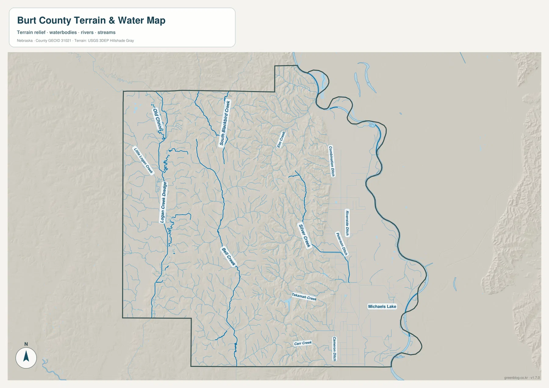
The Missouri River is the defining water feature on the eastern edge. Burt County’s official profile describes the river as the county’s eastern boundary and notes the productive bottomlands beside it. On the supplied terrain map, this part of the county is broad and flat compared with the heavily dissected country immediately to the west.
Little Logan Creek and Logan Creek Dredge occupy the west, while South Blackbird Creek and Bell Creek run through the central interior. These waterways follow long low valleys between the upland ridges. Their courses become even clearer on the elevation map, where the creek bottoms appear as narrow lower bands cutting through higher terrain.
Elm Creek and Silver Creek are visible closer to the east, and Tekamah Creek descends toward the Missouri lowland near the county seat. Carr Creek appears in the south. The eastern plain also contains named drainage works such as Combination Ditch and Riverside Ditch, showing that the water map includes both natural streams and constructed drainage channels.
Michaels Lake is labeled southeast of Tekamah near the river plain. The map is intended for geographic reference only. It does not establish flood risk, legal water rights, property boundaries, channel depth, navigability, or public access, all of which require current authoritative information.
Elevation rises sharply west of the Missouri River plain
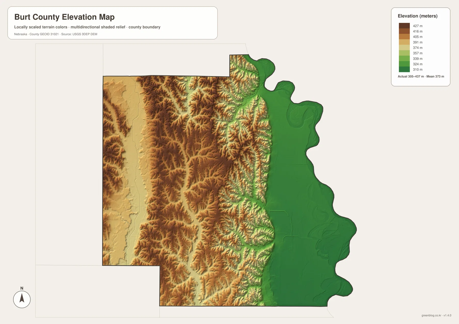
The elevation map reports an actual county-wide range of approximately 305 to 437 meters, with a mean near 373 meters. The lowest green terrain occupies the Missouri River plain along the entire eastern side. East and southeast of Tekamah, the land remains broad and relatively flat before meeting the river boundary.
Moving west from the river plain, the landscape changes quickly. Brown and darker ridges cover much of the central county, separated by narrow valleys occupied by Bell Creek, Silver Creek, Tekamah Creek, and numerous unnamed tributaries. The transition between the flat eastern lowland and these dissected hills is the strongest relief contrast on the map.
The far western side is still higher than the Missouri bottomlands but becomes somewhat broader and less sharply cut than the central bluff country. Oakland and Lyons sit within this higher agricultural landscape, while Tekamah lies close to the point where the hills descend into the eastern plain. That position helps explain the very different terrain visible over a relatively short distance.
The elevation colors are scaled locally for Burt County and are intended for relative comparison within this map. Similar colors on another county map may represent different absolute heights. The surface is generalized and should not be used as survey-grade information for engineering, construction, drainage design, or property work.
Tekamah sits close to the transition between bluffs and river bottomlands
The water and elevation views make Tekamah’s location especially clear. Tekamah Creek approaches from the hillier west, while the broad Missouri River lowland opens immediately to the east. U.S. 75 also follows this lower eastern side, putting the county seat near both a natural terrain break and a major transportation corridor.
History Nebraska’s Tekamah marker says the original townsite was chosen for abundant water, timber, stone, and the rich soil of the Missouri River Valley. The modern maps show the same basic setting: wooded and creek-cut uplands rise to the west, while fertile river bottomlands spread toward the Missouri on the east.
Burt County dates to Nebraska Territory’s first year
Burt County was created in 1854 and named for Francis Burt, Nebraska Territory’s first governor. History Nebraska notes that the county was originally larger and that its present boundaries were fixed in 1879. This long history makes Burt County one of Nebraska’s earliest organized county areas.
Tekamah and Decatur both developed during the first wave of settlement in the 1850s. Agriculture expanded rapidly in the Missouri River Valley, and later railroad service strengthened Tekamah’s role as a local center. The present map still shows the basic relationship between river-bottom communities, transportation routes, and the higher agricultural interior.
How to combine the Burt County map views
For basic orientation, locate Tekamah and the Missouri River first, then move north to Decatur and west toward Oakland, Lyons, and Craig. U.S. 75 and routes 51, 32, and 11 provide useful road references for connecting those places on the general map.
For physical geography, begin in the flat Missouri bottomlands and work westward. Tekamah Creek and Silver Creek lead into the central hills, followed by Bell Creek, South Blackbird Creek, and Logan Creek farther west. The elevation map shows how quickly the land rises away from the river plain and how deeply the creeks cut through the uplands.
The city map is the simplest choice when direct positional relationships from Tekamah are the main question. For larger labels and more visible stream detail, the downloadable high-resolution JPG files are preferable to the web previews. Each view emphasizes a different part of the same county landscape.
Frequently Asked Questions
Are the distances from Tekamah driving distances?
No. The city map shows straight-line distances of about 7 miles to Craig, 13 miles to Oakland, 16 miles to Decatur, and 17 miles to Lyons. Actual driving mileage depends on the road network and exact starting and ending points.
Where is the lowest terrain in Burt County?
The Missouri River bottomlands along the eastern side are the lowest part of the county. The map’s elevation range is about 305 to 437 meters, with a rapid rise into the dissected central hills west of the river plain.
Can the creek and ditch map be used for flood or property decisions?
No. It is a geographic reference showing the Missouri River edge, Logan Creek, Bell Creek, Tekamah Creek, drainage ditches, and Michaels Lake. Flood risk, water rights, property boundaries, and access questions require current authoritative records.
Map File Information
The ZIP contains the original high-resolution JPG files for the Burt County boundary and road map, city-connection map, terrain and water map, and elevation map.
- Included Files: Use only the versions confirmed in the article and supplied images
- File Type: Use the confirmed download contents
- Intended Use: Printing, education, presentations, and map-based projects
Related Maps
Sources and references
- Burt County – About Our County
- History Nebraska – Tekamah Historical Marker
- U.S. Census Bureau TIGER/Line Shapefiles
- USGS National Hydrography
- USGS 3D Elevation Program
These maps are intended for geographic reference. For legal boundaries, land ownership, flood determinations, water rights, road conditions, construction, surveying, or other decisions requiring current authoritative information, consult Burt County and the responsible state or federal agency.
Green Map creates custom-edited map images using open geographic data sources such as geoBoundaries, Natural Earth, OpenStreetMap, and government open data. These maps are edited visual materials, not raw data files, and are provided for education, documents, presentations, and graphic reference.