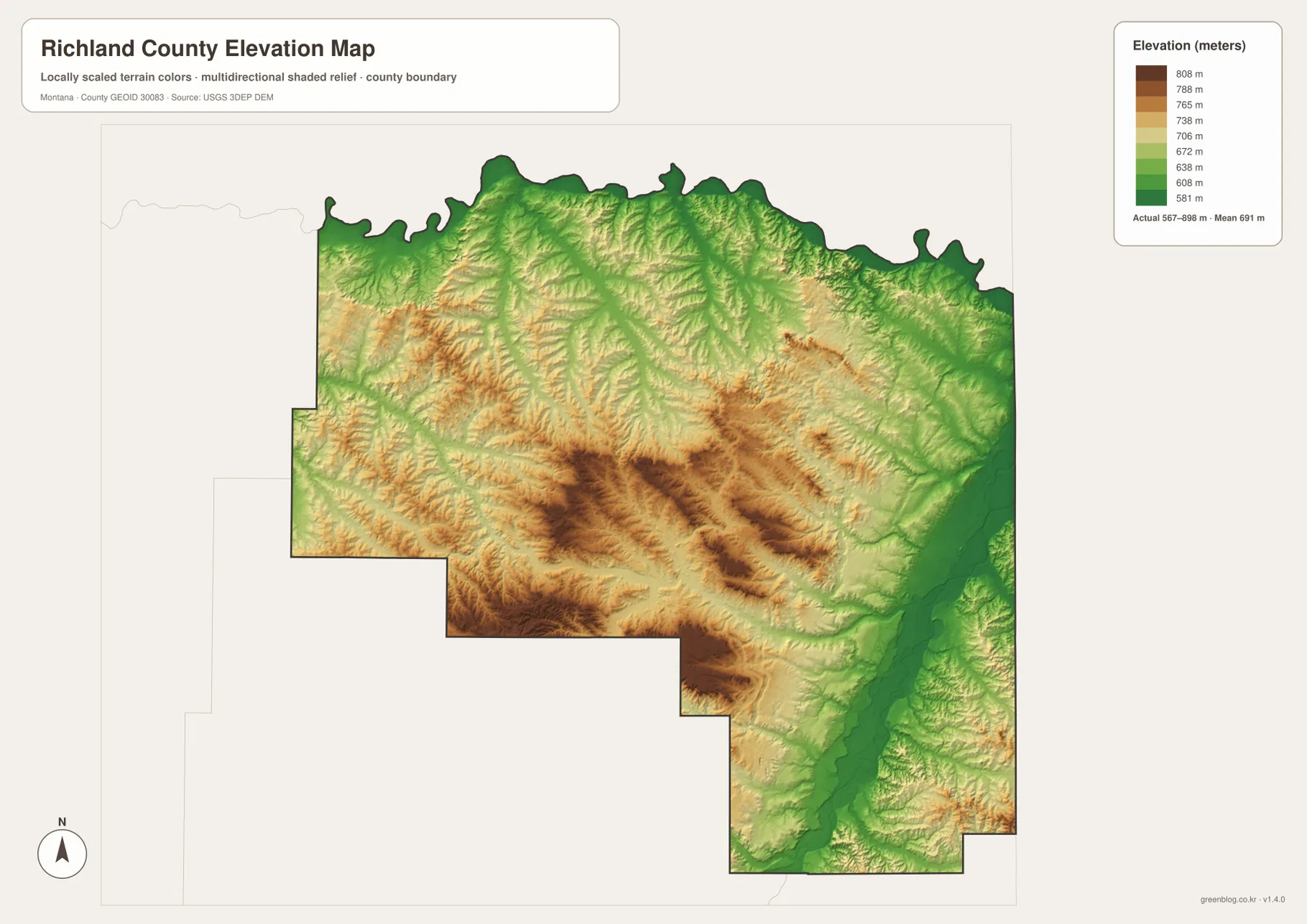
Richland County occupies Montana’s far east, where Sidney and Fairview sit beside the broad Yellowstone River lowland and the Missouri River forms the winding northern edge. Routes 200, 23, 68, 129, 248, and 201 provide the strongest road references around the eastern population centers, while a much sparser network reaches into the western uplands. The terrain-and-water map adds Yellowstone River, Missouri River, Lone Tree Creek, East Redwater Creek, Fox Creek, and several small reservoirs. The elevation map shows a clear contrast between low river corridors and higher rolling country to the west. High-resolution JPG versions of the maps are available together in the download ZIP below.
Richland County’s official website describes the county as part of the Yellowstone Valley and highlights the Lower Yellowstone Irrigation Project as an important agricultural resource. A county assessment also identifies the Missouri River as the northern boundary and describes Yellowstone River flowing across the southeastern part of the county toward North Dakota. Those two rivers provide the simplest natural framework for reading the maps, with Sidney and Fairview concentrated in the lower eastern landscape.
Table of Contents
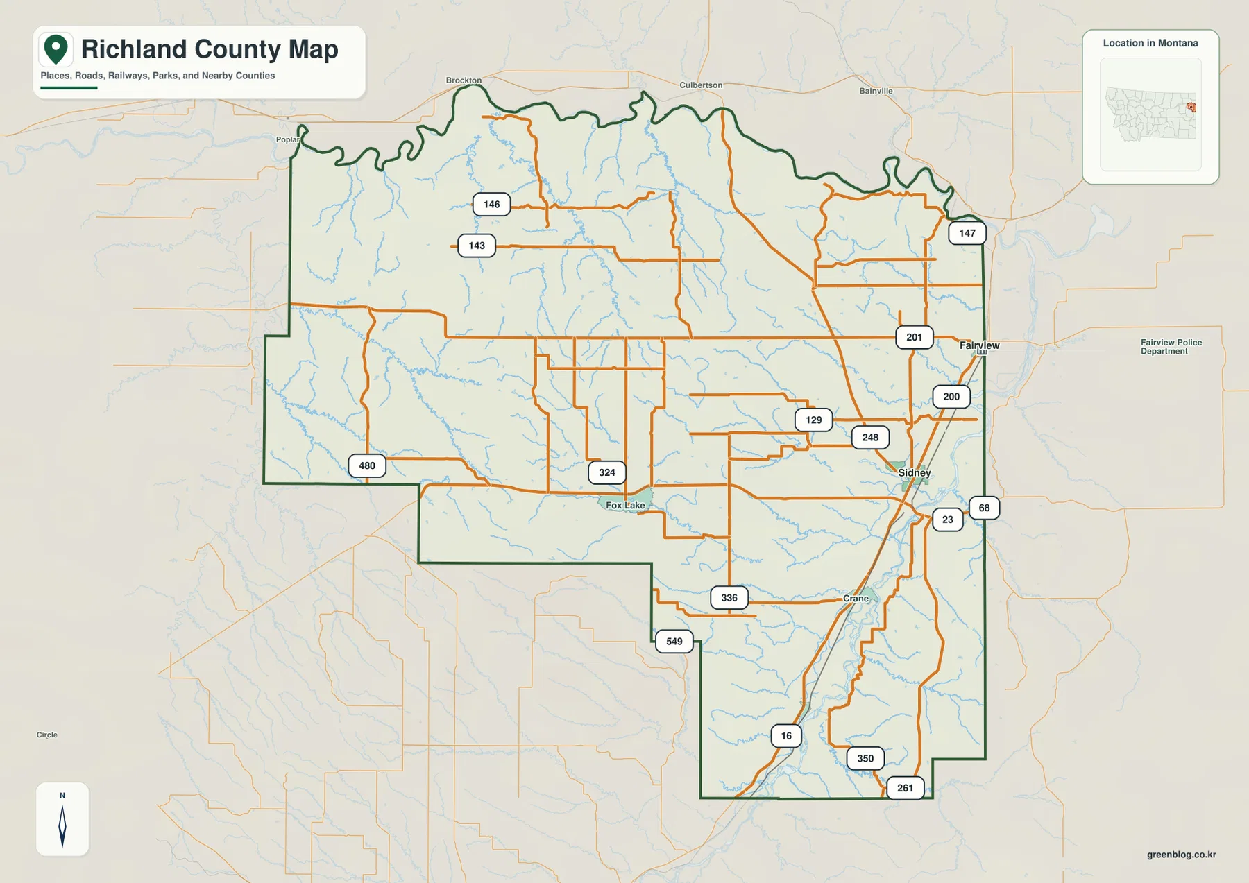
Sidney is the main road hub
On the general county map, Sidney is the strongest settlement and road reference in the southeast. Route 200 passes across the area, while Routes 23 and 68 help organize the eastern side. Routes 129 and 248 branch west from the Sidney area into a more open rural interior.
South of Sidney, Route 16 follows a long north-south course. Routes 350 and 261 appear near the southern end, while Crane provides another local place reference southwest of the city. This part of the county occupies a broad lowland with a dense network of streams and canals.
Farther west, Routes 324, 336, 480, and 549 cross sparsely settled country, with Fox Lake serving as a useful place label. Routes 143, 146, and 147 appear across the north. These maps show the overall layout rather than current road conditions, so construction, unpaved surfaces, and seasonal access should be checked separately.
Sidney and Fairview are the two ranked cities
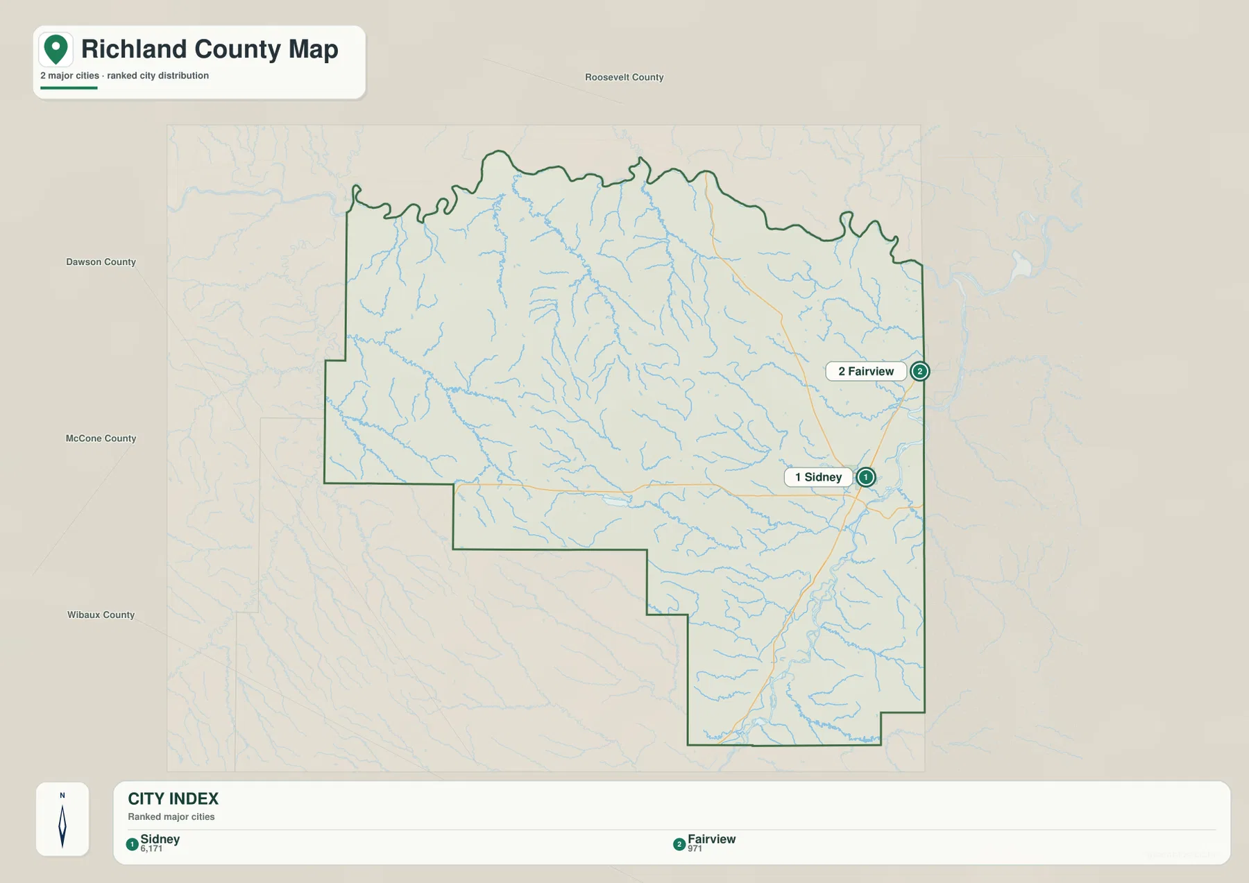
The city map ranks two places: Sidney and Fairview. Its CITY INDEX lists Sidney at 6,171 and Fairview at 971. These values are embedded in the supplied map and should not be treated as guaranteed current population estimates. Current demographic totals should be checked through recent U.S. Census Bureau data.
Sidney lies in the southeastern part of the county, while Fairview is farther north near the North Dakota line. Surrounding labels include Roosevelt, Dawson, McCone, and Wibaux counties, placing Richland County at the eastern edge of Montana.
No connector line or mileage label is printed between Sidney and Fairview. The visual spacing should therefore be treated only as a location reference, not as straight-line distance or road mileage. Actual travel should be checked on the general map and with current navigation information.
Yellowstone River creates the dominant eastern lowland
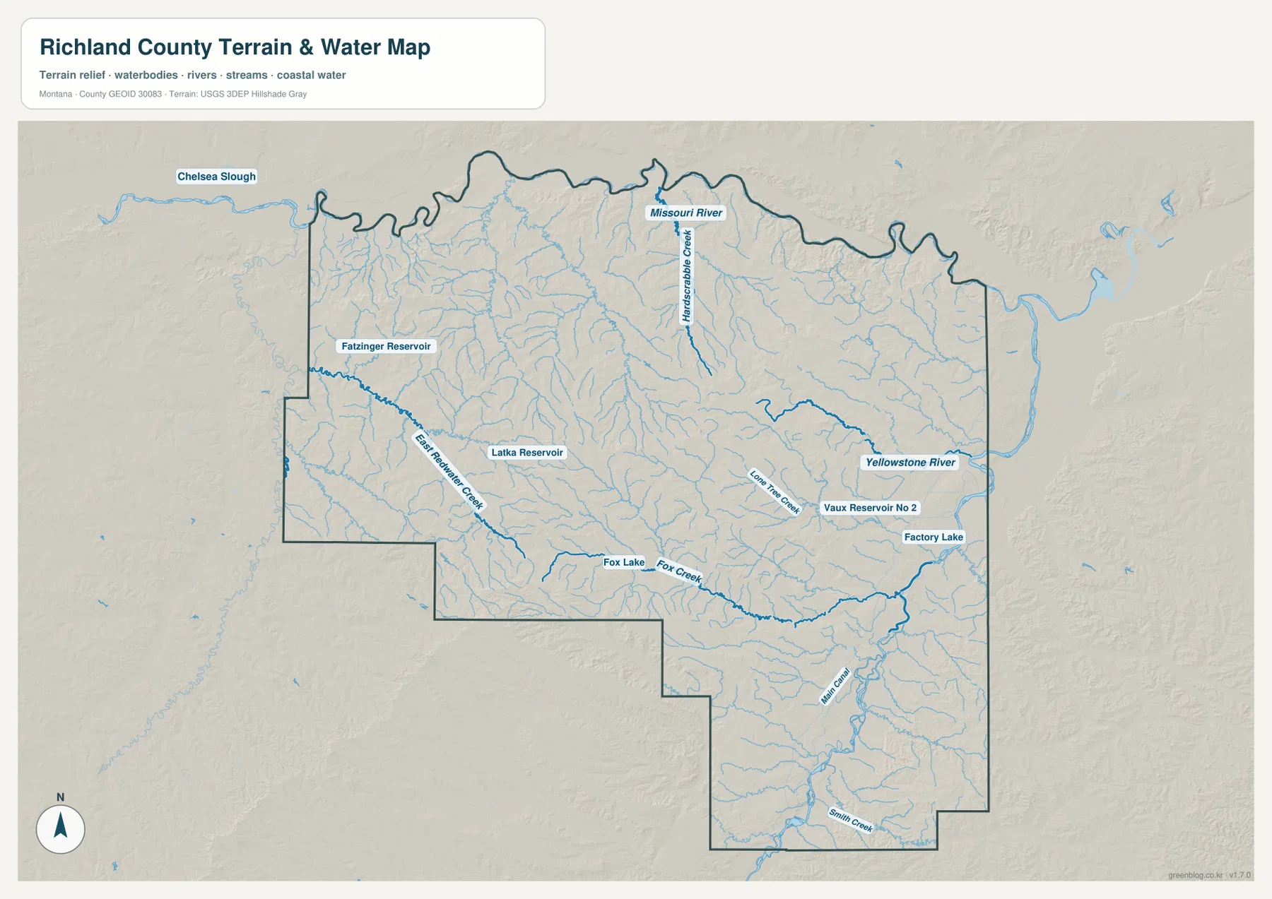
Yellowstone River is the strongest water feature along the eastern side of the county. It rises through the southeast and continues north toward the county’s northeastern edge, occupying a broad low corridor around the Sidney and Fairview side.
Lone Tree Creek is prominently labeled near Sidney, and Main Canal runs through the same general eastern lowland. Factory Lake and Vaux Reservoir No 2 provide smaller water landmarks near the Yellowstone corridor.
The terrain-and-water map is intended for geographic reference. It does not establish flood zones, water depth, parcel boundaries, water rights, navigation conditions, or safe stream crossings. Current water and access conditions should be checked through appropriate official sources.
Missouri River and western creeks organize the northern and interior uplands
Missouri River follows the winding northern county boundary. Richland County planning and assessment material likewise describes it as the northern edge of the county. Numerous small tributaries descend toward the river from the rolling terrain to the south.
East Redwater Creek provides one of the clearest western drainage references, while Fox Creek crosses the central-southern interior. Other labeled water features include Fatzinger Reservoir in the northwest, Latka Reservoir farther southeast, Fox Lake in the south-central area, and Chelsea Slough near the northwest.
This creates a strong east-west contrast. The east is dominated by the wide Yellowstone River valley, while the western and central parts are broken into many smaller creek valleys and reservoirs. The elevation map shows how those drainages cut through higher rolling ground.
Elevation ranges from about 567 to 898 meters
The elevation map reports an actual Richland County range of about 567 to 898 meters, with a mean elevation near 691 meters. The lowest ground appears along Yellowstone River in the east and Missouri River in the north, where dark and medium green colors form broad river corridors.
Higher terrain becomes much more common toward the west and west-central interior. Brown ridges are concentrated across the southwest and central-west, with several areas rising above 800 meters. These are rolling uplands cut by numerous tributary valleys rather than high mountain terrain.
Sidney and Fairview occupy the much lower eastern side of the county, where the Yellowstone valley broadens into flatter agricultural land. The elevation map is intended for county-wide comparison only and should not be used as survey-grade or engineering-grade data for a specific property.
Sidney and the two major rivers provide a simple framework
A practical way to read Richland County is to begin with Sidney and the cluster of Routes 200, 23, 68, 129, and 248. Fairview provides the northeastern city reference, while Route 201 helps orient the eastern edge. Crane and Fox Lake provide additional landmarks farther south and west.
Water features provide the next layer. Yellowstone River organizes the east, Missouri River the north, Lone Tree Creek the Sidney area, East Redwater Creek the west, and Fox Creek the interior. Factory Lake, Vaux Reservoir No 2, Latka Reservoir, Fatzinger Reservoir, and Fox Lake help distinguish more local sections.
The WebP images embedded in the article are convenient for quick browsing. The high-resolution JPG files in the ZIP are better for printing or enlarging small road, creek, and reservoir labels. Because these are static reference maps, current road access, river levels, and flood information should be checked through current official sources.
Frequently Asked Questions
Does the city map show the distance between Sidney and Fairview?
No. The city map ranks and locates Sidney and Fairview but does not print a connector line, straight-line distance, or road mileage between them. Use the general county map and current navigation information for an actual trip.
Where is the lowest terrain in Richland County?
The elevation map shows the lowest terrain along Yellowstone River in the east and Missouri River along the north. The western and west-central county is higher and more strongly dissected by creek valleys.
Can the 567–898 meter elevation range be used for a property or engineering project?
No. The range is a county-wide reference for comparing low river corridors with higher rolling uplands. Precise site elevations should come from an authoritative source such as the USGS 3D Elevation Program and, when necessary, a professional survey.
Map File Information
Download the Richland County county, city, terrain-and-water, and elevation maps as high-resolution A3 JPG files.
- Included Files: county map, city map, terrain and water map, elevation map
- File Type: ZIP containing 4 JPG files
Related Maps
Sources and References
County government and local background are available from the official Richland County website, which describes the county as part of the Yellowstone Valley and highlights the Lower Yellowstone Irrigation Project. A Richland County assessment identifies Missouri River as the northern boundary and describes Yellowstone River crossing the southeastern county toward North Dakota.
Boundary and road-reference data can be checked through U.S. Census Bureau TIGER/Line Shapefiles. Hydrographic data are available from USGS National Hydrography, and elevation data through the USGS 3D Elevation Program.
Green Map creates custom-edited map images using open geographic data sources such as geoBoundaries, Natural Earth, OpenStreetMap, and government open data. These maps are edited visual materials, not raw data files, and are provided for education, documents, presentations, and graphic reference.