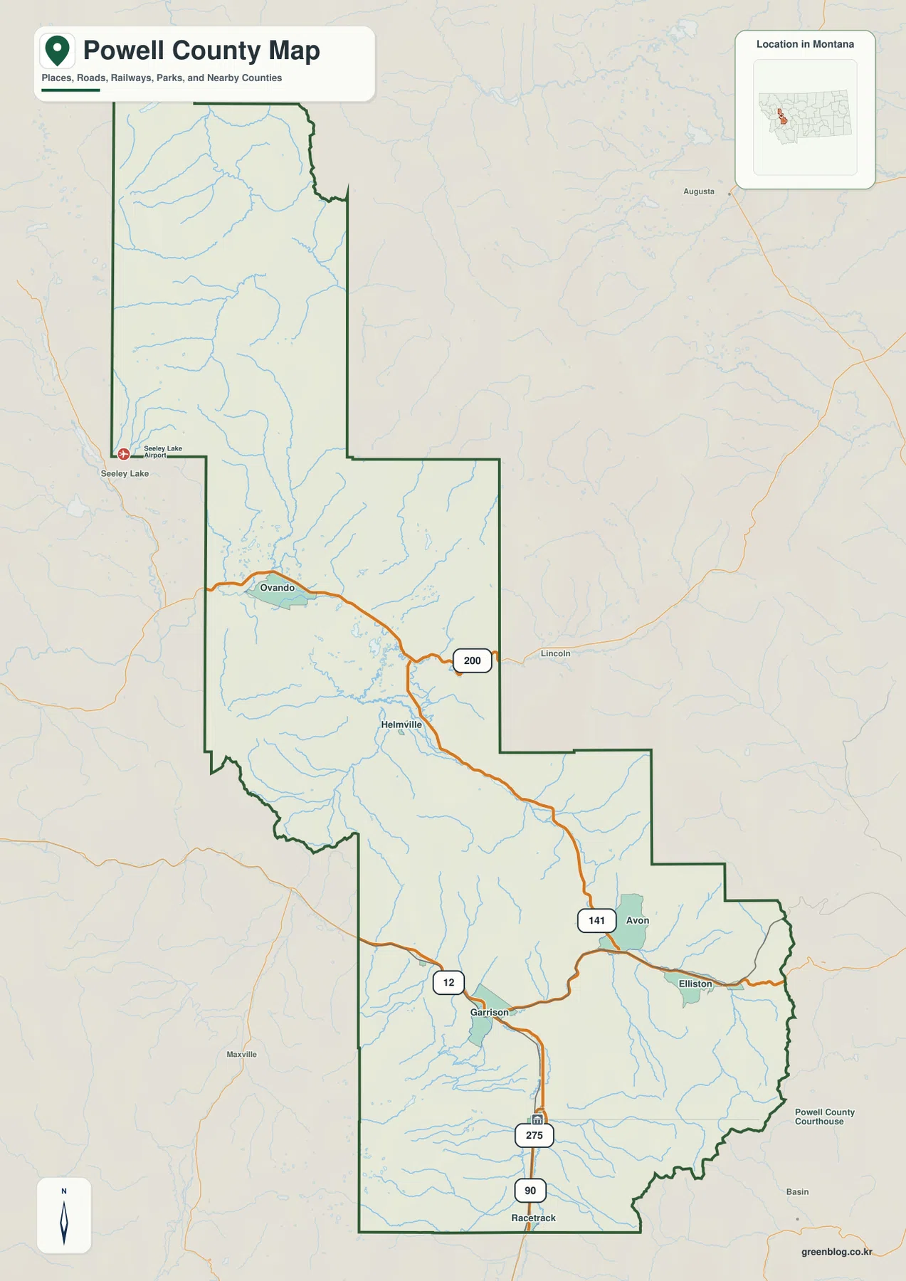
Powell County is a long north-south county in west-central Montana, stretching from the Deer Lodge area into a much more remote northern mountain region. The general map places Ovando, Helmville, Avon, Elliston, Garrison, and Racetrack along widely separated valleys, with Routes 200, 12, 141, and 275 serving as useful road references. The terrain-and-water map adds Blackfoot River, Little Blackfoot River, Clark Fork River, South Fork Flathead River, and a chain of mountain lakes. The elevation view makes the contrast especially clear: broad southern valleys sit far below the rugged northern ridges. High-resolution JPG versions of the maps are available together in the download ZIP below.
An official Powell County risk assessment describes the county as long and narrow with a north-south orientation, notes that the northern third contains undeveloped portions of the Bob Marshall Wilderness Complex, and identifies Deer Lodge as the county seat and largest city. Those facts match the supplied maps well. A practical way to understand the county is to start at Deer Lodge in the south, follow the central communities toward Ovando, and then use the river systems to organize the northern mountains.
Table of Contents
Route 200 links Ovando and Helmville across the central county
On the general county map, Route 200 is the strongest road reference across the central section. It passes the Ovando area and continues toward Helmville, while Lincoln appears outside the eastern boundary as a useful directional reference. The country around Ovando is broader and more open than the high terrain farther north.
South of Helmville, Avon appears along the next major valley, with Route 141 providing an important north-south road reference. Farther south, Elliston and Garrison occupy another corridor where Route 12 enters from the west.
Near the southern end, Route 275 is labeled above Racetrack. Deer Lodge itself is not prominent on the general map, but the city map clearly identifies it as the county’s only ranked major city. Current winter restrictions, construction, and remote-road conditions should be checked separately.
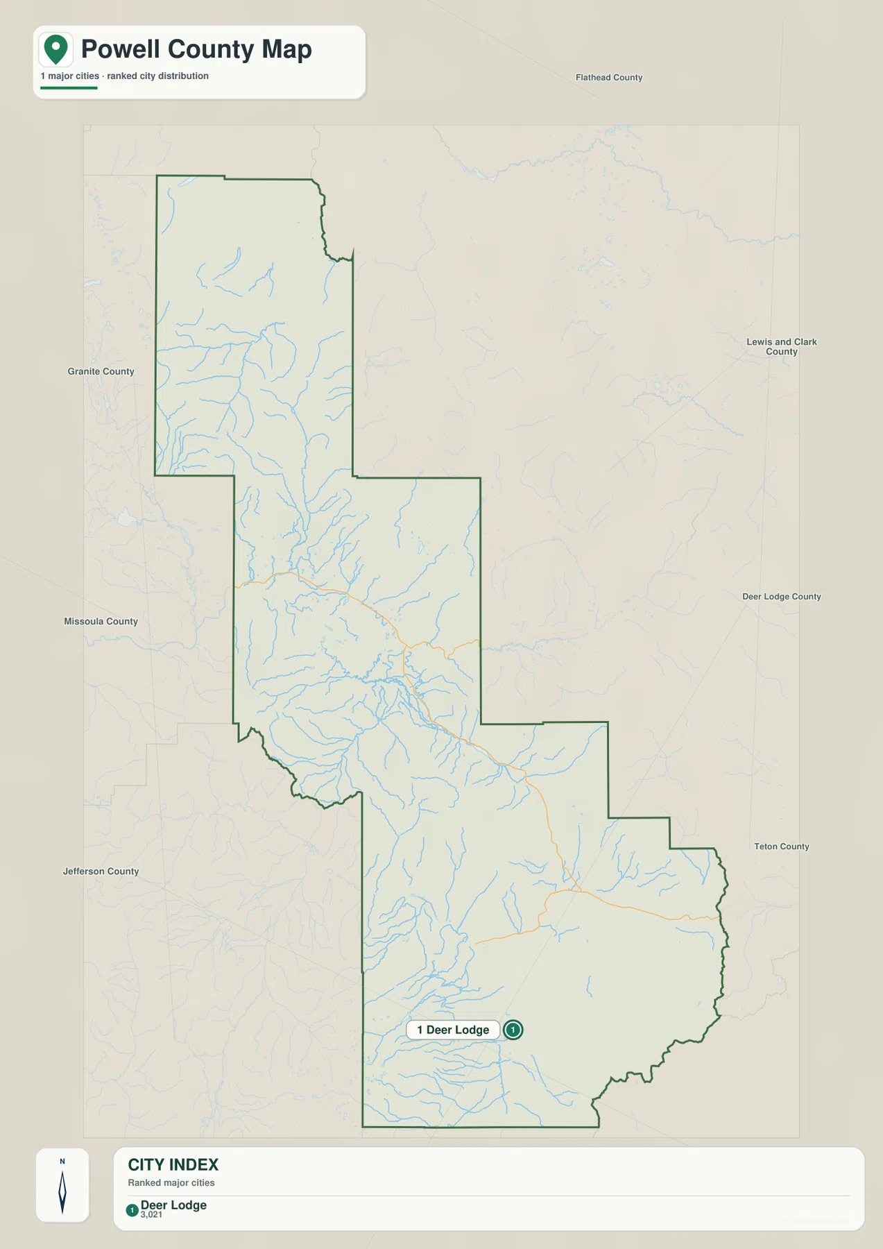
Deer Lodge is the only ranked city
The city map contains one ranked place: Deer Lodge. Its CITY INDEX lists a value of 3,021. This figure is embedded in the supplied map and should not be treated as a guaranteed current population estimate. Current demographic totals should be checked through recent U.S. Census Bureau data.
Deer Lodge lies in the southern part of the county, while surrounding county labels include Granite, Missoula, Jefferson, Deer Lodge, Lewis and Clark, Flathead, and Teton counties. The elongated boundary shows how far Powell County reaches from the southern Deer Lodge valley into the northern mountains.
Because Deer Lodge is the only ranked city, the map contains no connector lines or mileage labels. No straight-line or driving distance should be inferred between Deer Lodge and places such as Ovando or Helmville. Actual trips should be checked on the general road map and with current navigation information.
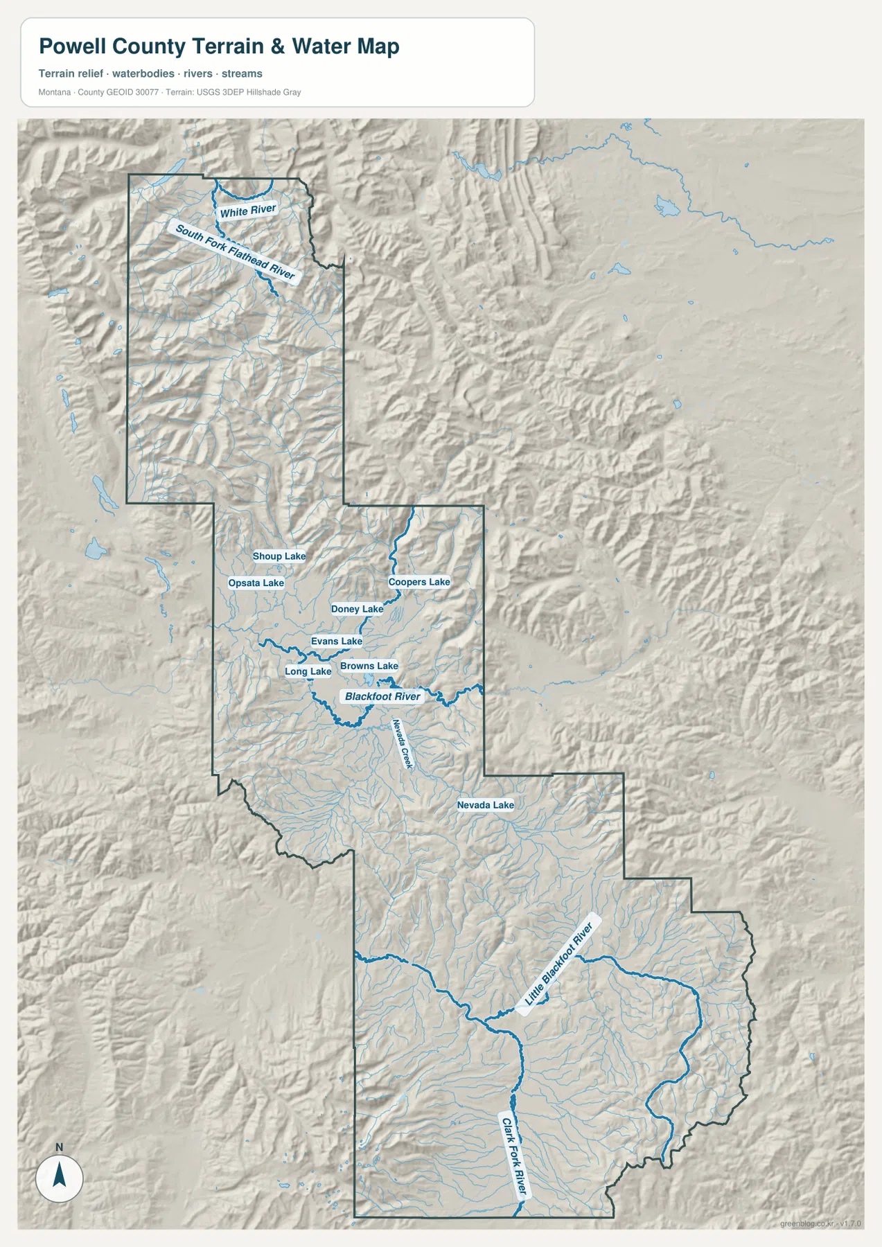
Blackfoot River and mountain lakes organize the central basins
Blackfoot River is the strongest water reference across the central county. It runs west-east below Browns Lake and Evans Lake, creating a lower valley through otherwise rugged terrain. Nevada Creek approaches from the south and provides another long drainage reference.
North of the river, Long Lake, Browns Lake, Evans Lake, Doney Lake, Coopers Lake, Shoup Lake, and Opsata Lake occupy separate mountain basins. These water bodies are especially useful in country where major roads and settlements are sparse. Nevada Lake provides a distinct landmark farther southeast.
The terrain-and-water map is intended for geographic reference. It does not establish flood zones, water depth, parcel boundaries, water rights, navigation conditions, or safe stream crossings. Current water and access conditions should be checked through appropriate official sources.
South Fork Flathead and Clark Fork define opposite ends of the county
At the far north, South Fork Flathead River cuts through rugged mountain terrain, while White River occupies another nearby valley. The road map is almost empty in this section, but the water map reveals a dense network of streams and deep mountain drainages.
In the south, Little Blackfoot River follows a longer east-west valley, and Clark Fork River crosses close to the southern boundary. These larger valleys help explain the broader terrain around Garrison and Deer Lodge compared with the narrow northern mountain corridors.
The northern and southern river landscapes are therefore quite different. The north is dominated by tightly packed ridges and narrow drainages, while the south contains broader low valleys framed by mountain ranges. The elevation map makes that contrast especially easy to see.
Elevation ranges from about 1,177 to 3,074 meters
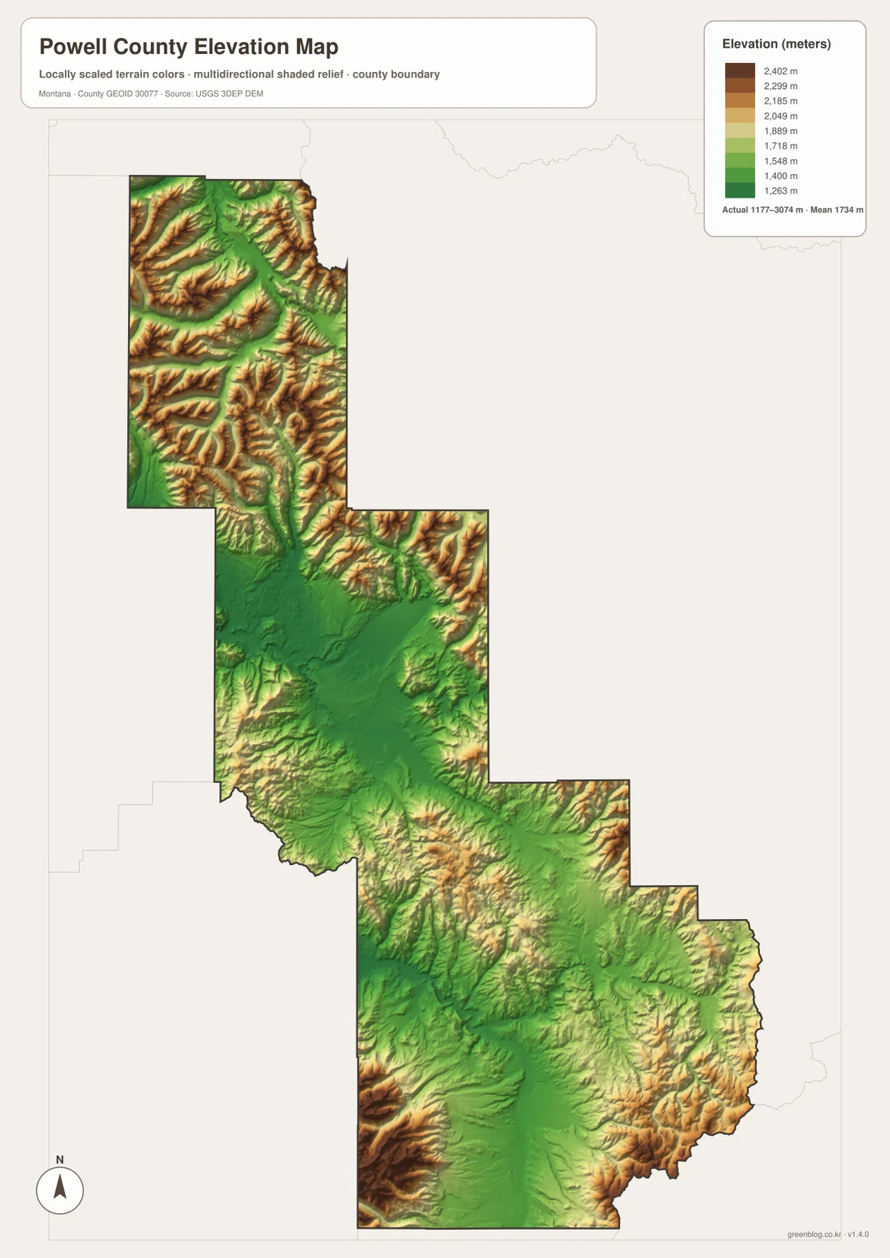
The elevation map reports an actual Powell County range of about 1,177 to 3,074 meters, with a mean elevation near 1,734 meters. The Deer Lodge area and southern river valleys appear in green, while the northern and northwestern county is dominated by yellow and brown mountain ridges.
The northern section contains tightly spaced high ridges cut by South Fork Flathead River and numerous tributaries. Central Powell County also contains extensive high terrain around the lower Blackfoot River basin, with mountain slopes rising on both sides.
Southern Powell County is generally lower, although high mountains return along the southwestern and southeastern edges. The elevation map is intended for county-wide comparison only and should not be used as survey-grade or engineering-grade data for a specific property.
Deer Lodge and Blackfoot River provide a simple framework
A practical way to read Powell County is to begin with Deer Lodge in the south, then follow Garrison, Elliston, Avon, Helmville, and Ovando northward. Route 200 becomes the key central road, while Routes 12, 141, and 275 help identify the southern corridors.
Water features provide the next layer. Blackfoot River organizes the central county, South Fork Flathead River the far north, and Little Blackfoot plus Clark Fork rivers the south. Browns, Evans, Long, Doney, Coopers, and Nevada lakes add useful landmarks in the mountain interior.
The WebP images embedded in the article are convenient for quick browsing. The high-resolution JPG files in the ZIP are better for printing or enlarging small road, river, and lake labels. Because these are static reference maps, current road access, water levels, and seasonal restrictions should be checked through current official information.
Frequently Asked Questions
Does the Powell County city map show distances between cities?
No. Deer Lodge is the only ranked city on the supplied city map, so there are no connector lines, straight-line distances, or road mileages to other cities.
Where is the highest terrain in Powell County?
The elevation map shows the highest terrain across the northern and northwestern mountains and along several county-edge ranges. Deer Lodge and the broad southern river valleys are much lower.
Can the 1,177–3,074 meter elevation range be used for a property or engineering project?
No. The range is a county-wide reference for comparing lower valleys with high mountain terrain. Precise site elevations should come from an authoritative source such as the USGS 3D Elevation Program and, when necessary, a professional survey.
Map File Information
Download the Powell County county, city, terrain-and-water, and elevation maps as high-resolution A3 JPG files.
- Included Files: county map, city map, terrain and water map, elevation map
- File Type: ZIP containing 4 JPG files
Related Maps
Sources and References
County government information is available from the official Powell County website. The county’s Wildland Urban Interface & Risk Assessment describes Powell County as long and narrow, identifies Deer Lodge as the county seat and largest city, and notes that the northern portion includes the Bob Marshall Wilderness Complex.
Boundary and road-reference data can be checked through U.S. Census Bureau TIGER/Line Shapefiles. Hydrographic data are available from USGS National Hydrography, and elevation data through the USGS 3D Elevation Program.
Green Map creates custom-edited map images using open geographic data sources such as geoBoundaries, Natural Earth, OpenStreetMap, and government open data. These maps are edited visual materials, not raw data files, and are provided for education, documents, presentations, and graphic reference.