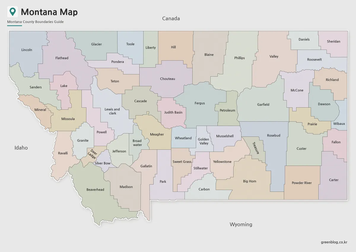
Cascade County in north-central Montana is organized around Great Falls and the Missouri River, with broad lower country to the north and west and progressively higher terrain toward the south and southeast. I-15, U.S. 87, and Montana 200 converge around Great Falls, while communities such as Sun River, Fort Shaw, Simms, Ulm, Cascade, Sand Coulee, and Belt spread into different valleys. Neihart lies much farther southeast in markedly higher country. The maps on this page can be viewed online, and the matching high-resolution JPG files are available together in the download ZIP below.
Cascade County’s official Quick Facts identifies Great Falls as the county seat, and the maps make its central role easy to see. The Missouri River and Sun River meet near the city, Malmstrom AFB lies just to the east, and several major roads fan outward from the same area. Farther south, Smith River and Belt Creek occupy narrower valleys in rougher terrain. Starting with Great Falls and then following roads and waterways outward gives a simple way to understand a county that changes substantially from north to south.
Table of Contents
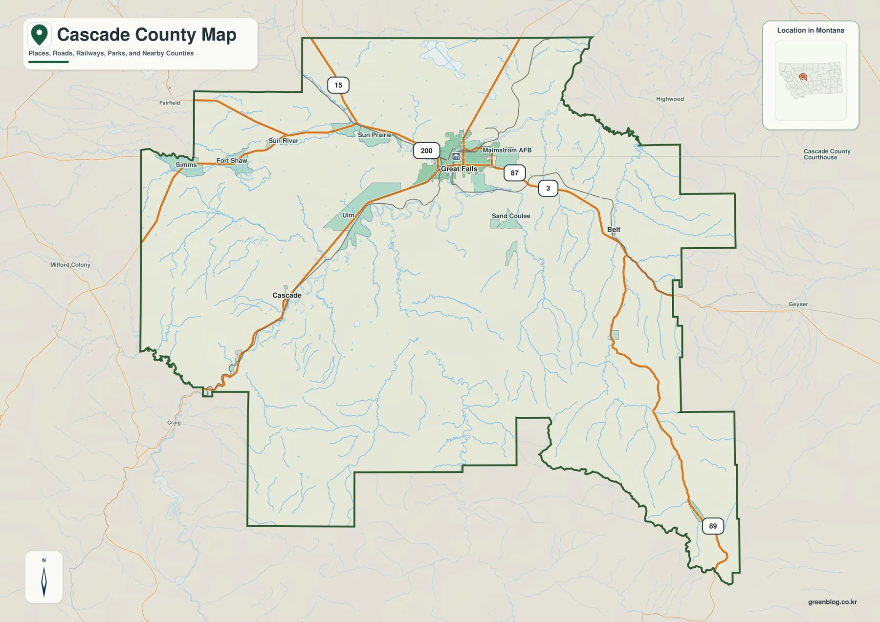
Great Falls is the junction for the county’s main road directions
On the general county map, Great Falls sits in the north-central portion of Cascade County. I-15 runs through the area, Montana 200 approaches from the west through the Sun Prairie and Sun River side, and U.S. 87 is labeled east of the city. Route 3 also appears on the eastbound corridor. This concentration of numbered highways makes Great Falls the clearest starting point for locating communities across the county.
West of Great Falls, Sun River, Fort Shaw, and Simms follow a broad lower corridor. Ulm and Cascade lie to the south and southwest, while Malmstrom AFB and Sand Coulee sit east and southeast of the city. Belt is farther east, where the road begins entering a more strongly dissected landscape. The county’s long southeastern extension continues toward Neihart along the Route 89 corridor, where the map’s terrain shading becomes increasingly rugged.
The county outline is irregular, with a wide western half, a stepped eastern boundary, and a long southeastern projection. That shape makes straight-line proximity deceptive in some areas. A location that looks close across the boundary may still require a road that follows a river valley or passes around higher ground. The map is useful for regional orientation, but live road conditions, seasonal closures, and drive times should be checked separately.
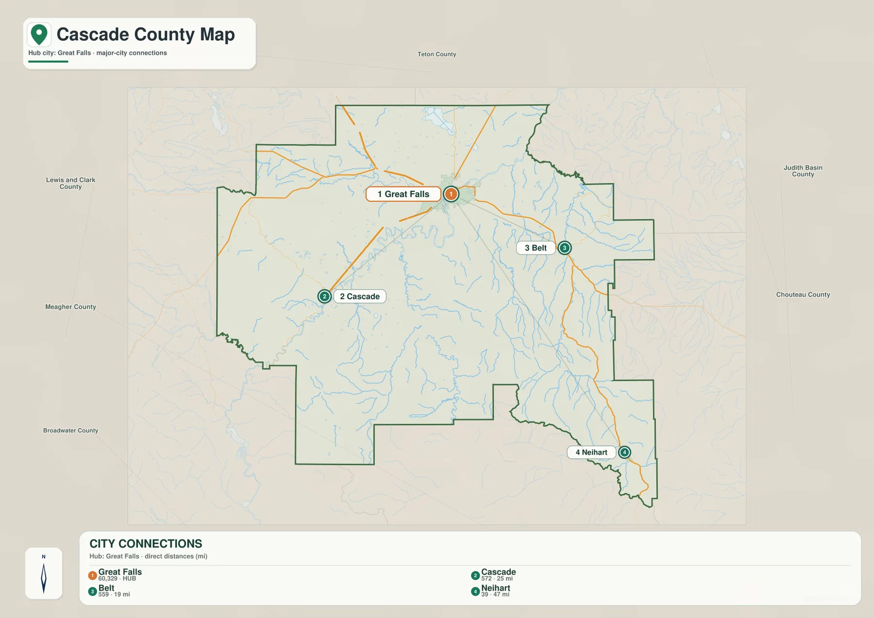
City connections use Great Falls as the hub and show straight-line distance
The city-connections map uses Great Falls as the hub and links it to Cascade, Belt, and Neihart. The printed index lists Great Falls at 60,329, Cascade at 572, Belt at 559, and Neihart at 39. Those population figures are the values embedded in the supplied map and should not be treated as guaranteed current estimates. For current demographic totals, consult recent U.S. Census Bureau releases.
The distance values are straight-line distances, not road mileage. Cascade is labeled 25 miles from Great Falls, Belt 19 miles, and Neihart 47 miles. Actual driving distances can be longer because the highway network follows valleys and avoids steep terrain. This distinction matters most for Neihart, which is not only farther from Great Falls but also sits near the county’s highest and most rugged southeastern terrain.
The map also shows the directional relationship among the four places. Belt lies east-southeast of Great Falls, Cascade lies to the southwest, and Neihart is much farther southeast. Sand Coulee sits between Great Falls and the Belt side on the general map, while the route toward Cascade follows the Missouri River corridor. The connection map is therefore best used for relative position and straight-line comparison rather than trip planning.
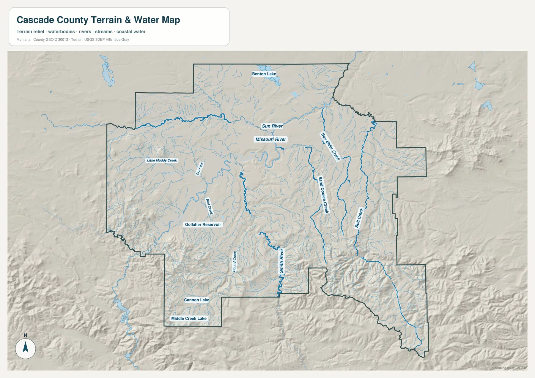
The Missouri and Sun rivers define the Great Falls lowland
The terrain-and-water map makes the Missouri River the dominant central feature. The Sun River approaches from the west and joins the Missouri near Great Falls, while the Missouri continues through a broad low corridor across the county. This meeting of major waterways occurs in the same general area as the county’s largest city and principal road junction, which makes the map especially useful for understanding Great Falls in its physical setting.
Benton Lake is labeled in the north, and smaller western drainages include Little Muddy Creek, Dry Fork, and Bird Creek. Gollaher Reservoir appears in the southwest interior, while Cannon Lake and Middle Creek Lake lie near the southern boundary. These smaller water bodies are useful local references after the Missouri and Sun rivers have been located.
East and southeast of Great Falls, Box Elder Creek, Sand Coulee Creek, and Belt Creek form long drainage lines. Belt Creek is particularly useful for locating the eastern and southeastern part of the county because it runs through increasingly rugged terrain toward the Neihart side. This map is a geographic water reference; it should not be used as a flood-hazard map, navigation chart, property survey, water-rights record, or guide to safe crossings.
Smith River and Belt Creek lead into narrower southern valleys
The southern half of Cascade County is more strongly divided by valleys than the Great Falls area. Smith River is labeled through the south-central part of the map and receives tributaries such as Indian Creek. Belt Creek runs through the eastern side and gathers water from the high country before continuing north. These channels occupy long lower corridors between increasingly steep ridges.
The change is especially noticeable toward Neihart. Terrain shading becomes stronger, creek valleys narrow, and Route 89 follows the southeastern portion of the county through much rougher country than the open plains around Great Falls. The road and stream do not follow identical lines, but both are constrained by the same broad pattern of ridges and valleys.
Elevation rises from about 833 meters to 2,610 meters
The elevation map reports an actual county range of about 833 to 2,610 meters, with a mean elevation near 1,307 meters. Great Falls and much of the northern and northwestern county appear in lower green tones. Moving south, yellow and brown become increasingly common, with the strongest concentration of high terrain in the southeastern extension near Neihart and the mountains beyond it.
High terrain also appears in the southwest, although it is less continuous than the southeastern high country. Across the middle of the county, river and creek valleys cut lower routes through otherwise rolling or rugged ground. Comparing the elevation surface with the terrain-and-water map makes the Smith River and Belt Creek corridors easier to recognize because their valleys sit below the adjacent ridges.
A smaller high area also appears along part of the eastern boundary, while the Belt-to-Neihart section shows a marked increase in relief. This helps explain why Neihart can feel more remote than its straight-line distance alone suggests. The elevation map is intended for county-wide comparison and should not be treated as survey-grade, engineering-grade, or parcel-specific elevation data.
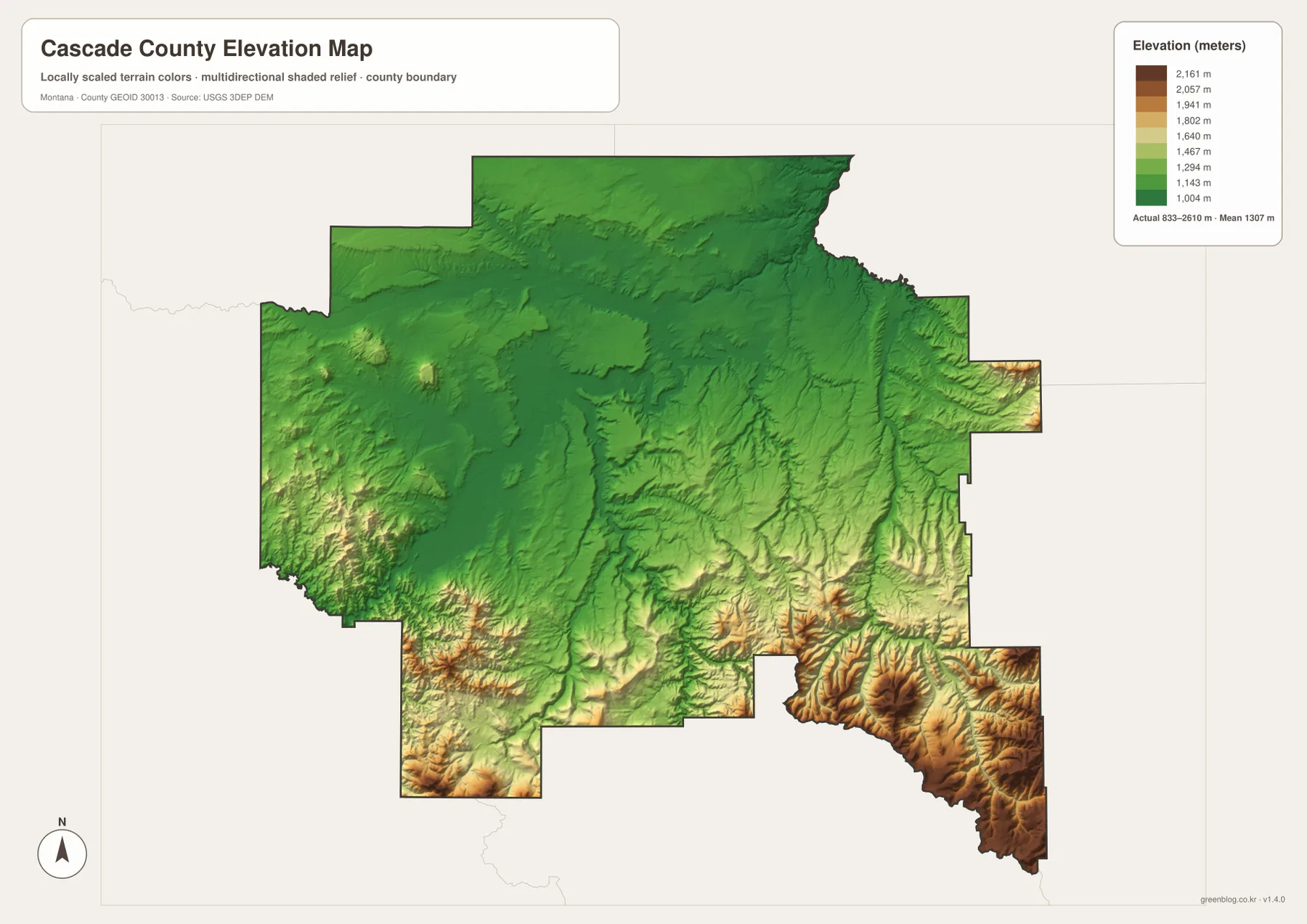
A Great Falls-centered view connects roads, rivers, and relief
A practical way to use the map set is to begin in Great Falls and work outward by direction. The western side leads through Sun River, Fort Shaw, and Simms. The south-southwest route reaches Ulm and Cascade along the broader Missouri corridor. Eastward, Malmstrom AFB and Sand Coulee lead toward Belt, while the long southeastern route continues toward Neihart and the highest terrain in the county.
Waterways provide a second layer of orientation. Near Great Falls, the Missouri and Sun rivers are the strongest references. Belt Creek and Sand Coulee Creek help organize the eastern side, while Smith River provides a clear south-central landmark. Once those major channels are familiar, smaller reservoirs and lakes become easier to place without turning the map into a list of isolated names.
The WebP images embedded in the article are convenient for quick viewing. The high-resolution JPG files in the ZIP are better for printing or enlarging small road and creek labels. These are static reference maps, so changing conditions such as road closures, river levels, or access restrictions should be checked through current official sources before travel or field use.
Frequently Asked Questions
Are the Great Falls-to-Cascade, Belt, and Neihart distances driving distances?
No. The city map labels Cascade at 25 miles, Belt at 19 miles, and Neihart at 47 miles from Great Falls as straight-line distances. Driving distances can be longer because roads follow available valleys and routes through the terrain.
Where is the highest terrain in Cascade County on this map?
The strongest concentration of high elevation is in the southeastern part of the county around and south of Neihart. Great Falls and much of the northern and northwestern county are considerably lower on the supplied elevation map.
Can the Missouri River and Belt Creek be compared on the same map?
Yes. The terrain-and-water map shows the Missouri River through the Great Falls area and Belt Creek along the eastern and southeastern side. Comparing them helps distinguish the broad central lowland from the narrower, higher-relief country toward Neihart.
Map File Information
Download the Cascade County county, city, terrain-and-water, and elevation maps as high-resolution A3 JPG files.
- Included Files: county map, city map, terrain and water map, elevation map
- File Type: ZIP containing 4 JPG files
Related Maps
Sources and References
Cascade County identifies Great Falls as the county seat on its official Quick Facts page. County boundary and road-reference data can be checked through U.S. Census Bureau TIGER/Line Shapefiles.
Hydrographic reference data are available from USGS National Hydrography, and elevation data can be checked through the USGS 3D Elevation Program.
Green Map creates custom-edited map images using open geographic data sources such as geoBoundaries, Natural Earth, OpenStreetMap, and government open data. These maps are edited visual materials, not raw data files, and are provided for education, documents, presentations, and graphic reference.