Warren County lies west of the St. Louis metropolitan area, with a developed I-70 corridor crossing a landscape that becomes much more rural toward the west, north, and Missouri River. Warrenton, Truesdale, Wright City, and Foristell line up along the interstate, while Marthasville sits farther south near the river and Innsbrook occupies a lake-rich area southeast of the main highway corridor. High-resolution map files are available for download in the section below.
This page combines the main roads and communities with the Missouri River, Lost Creek, Big Creek, Charrette Creek, and an elevation range of roughly 137 to 291 meters. A separate city view makes the six largest highlighted places easier to compare, and high-resolution JPG originals of all four maps can be downloaded together in one ZIP for enlargement, A3 printing, classroom materials, reports, or personal reference.
Table of Contents
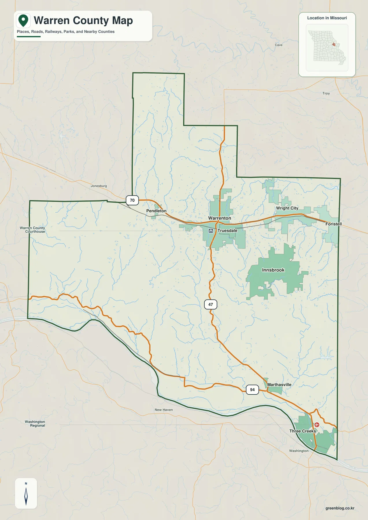
I-70 connects the county’s main urban corridor
I-70 is the clearest road reference on the general map. It enters from the west near Pendleton, crosses Warrenton and Truesdale, then continues through Wright City toward Foristell and St. Charles County. Because four of the county’s principal communities sit close to the same highway, the interstate provides a simple way to understand the developed eastern and central portions.
Warrenton is the key midpoint. Route 47 crosses the city north to south, and Warren County’s official directory places both the county administration building and courthouse in Warrenton. Truesdale lies immediately east, while Wright City is farther along I-70, creating a continuous sequence of urban references rather than one isolated county seat.
Foristell sits near the eastern edge and marks the transition toward the St. Louis-side suburbs. West of Warrenton, Pendleton and nearby rural areas have much less urban development. The difference is easy to see on the map because street and development density drops quickly away from the I-70 communities.
The county boundary is also distinctive. A long northern projection rises above the main body, the eastern side steps outward in several stages, and the southern edge follows the broad bends of the Missouri River. Keeping that outline in mind helps separate the northern rural uplands from the riverfront south.
Warrenton leads a split pattern between the interstate and riverfront
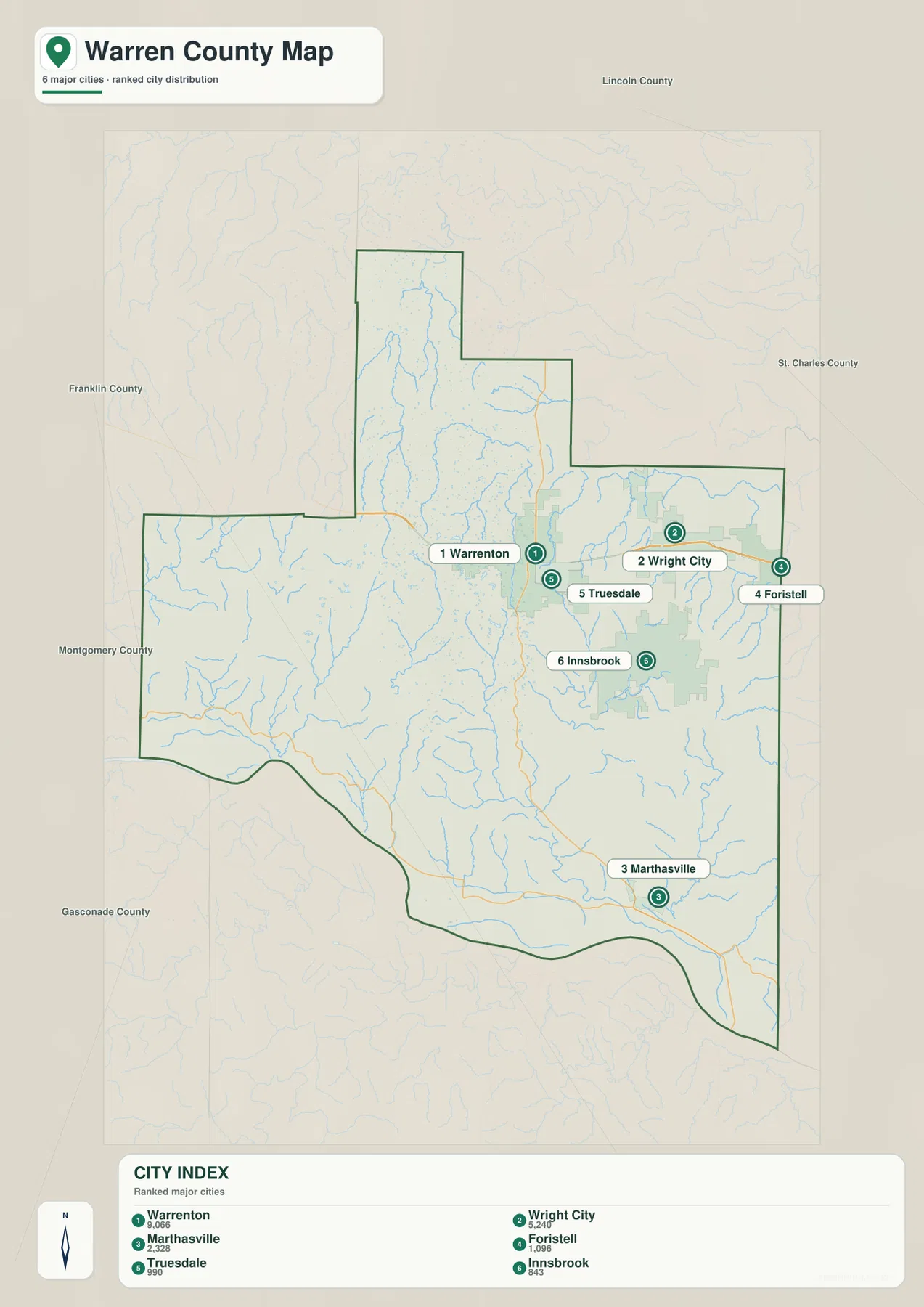
The city map highlights Warrenton, Wright City, Marthasville, Foristell, Truesdale, and Innsbrook. The map index labels Warrenton with 9,066, Wright City with 5,240, Marthasville with 2,328, Foristell with 1,096, Truesdale with 990, and Innsbrook with 843. Warrenton is clearly first, but the six places occupy more than one geographic cluster.
Warrenton, Truesdale, Wright City, and Foristell follow the I-70 corridor, while Marthasville is separated from them near the Missouri River in the southeast. Innsbrook occupies a broad area south of the interstate and is closely associated on the map with several lakes. This makes the city pattern look less like a single continuous belt once the southern half is included.
Marthasville is especially useful when locating Route 94 and the riverfront, while Innsbrook helps identify the central-eastern lake district. Wright City and Foristell provide strong eastern references toward St. Charles County. Each community therefore works as a different orientation point rather than simply another item in a population ranking.
Pendleton, Three Creeks, and other smaller labels also appear on the general map. The ranked city layer should be treated as a quick guide to the six highlighted communities, with the general map used afterward for the smaller roads, streams, and nearby places.
Missouri River lowlands meet Lost Creek and Big Creek valleys
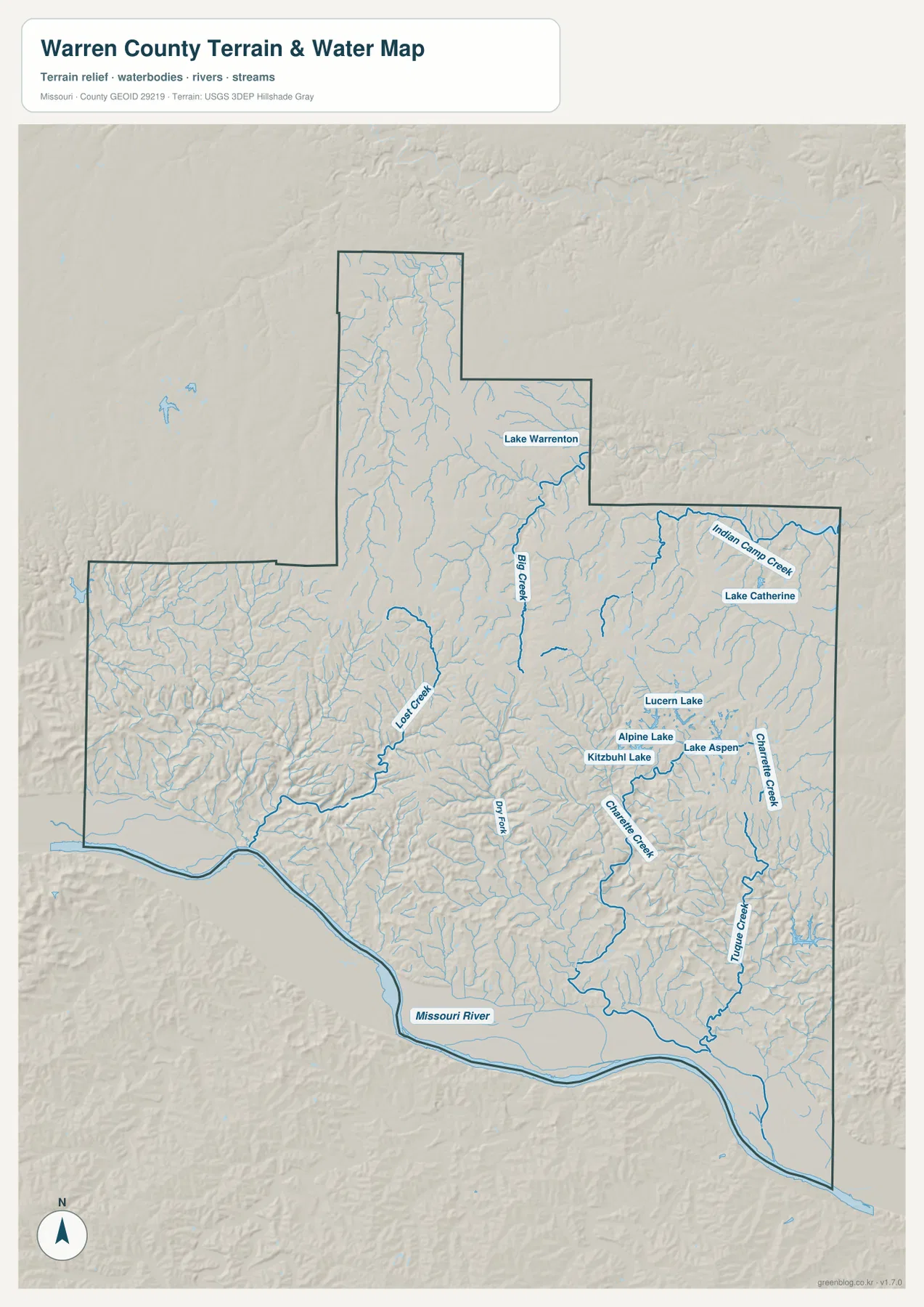
The Missouri River dominates the southern edge of the terrain-and-water map. It follows a broad, winding boundary from southwest to southeast and creates the county’s most extensive lowland. The riverfront near Marthasville and Three Creeks is much lower than the uplands immediately to the north.
Lost Creek cuts through the central-western interior, while Big Creek forms a long valley north of Warrenton. Indian Camp Creek provides a northeastern reference, and Charrette Creek and Tuque Creek cross the eastern and southeastern hills. The many small tributaries show how thoroughly streams divide the rolling interior.
Several lakes are useful local landmarks. Lake Warrenton sits north of the main city, while Alpine Lake, Kitzbuhl Lake, Lake Aspen, and Lucern Lake cluster around the Innsbrook area. Lake Catherine lies farther northeast and helps distinguish the Wright City side from the central lake district.
The terrain-and-water map is intended for geographic reference, not flood determination, current lake level, navigation, parcel boundaries, or legal water boundaries. Missouri River, creek, and lake conditions can change, so current flood or safety decisions should rely on up-to-date official information.
Elevation rises from about 137 to 291 meters away from the river
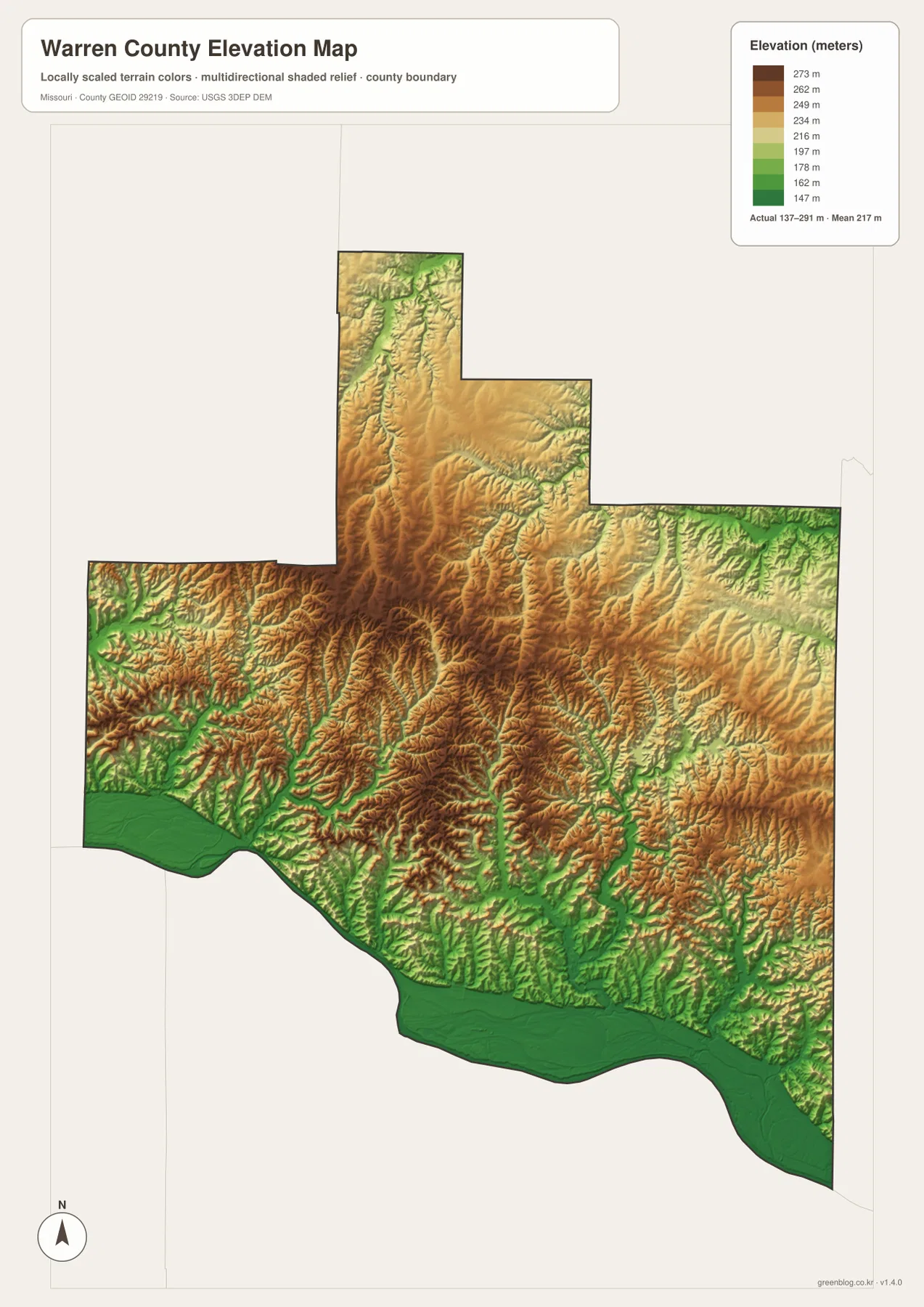
The elevation map reports an actual range of roughly 137 to 291 meters and a mean near 217 meters. The lowest dark-green terrain follows the Missouri River across the south, creating a continuous low belt that stands out immediately from the higher interior.
Higher tan and brown terrain spreads across the central and western county. The Lost Creek side contains closely spaced ridges and valleys, and several central uplands rise above 250 meters. The developed I-70 corridor therefore crosses rolling terrain rather than one broad level plain.
In the northern projection, Big Creek creates a narrow lower corridor between higher ridges. Farther east, Indian Camp Creek and Charrette Creek create similar green valleys, although the surrounding uplands are generally gentler. The overall pattern is a very low riverfront, higher central uplands, and repeated stream-cut valleys.
This county-scale elevation surface is useful for broad relief comparison, not for engineering, construction, drainage design, parcel-level elevation decisions, or survey-grade measurement. Site-specific work requires more detailed official elevation data or field surveying.
Compare the I-70 communities with river bluffs and interior creek valleys
Start with Warrenton and I-70 when roads and settlement locations matter most. Truesdale, Wright City, and Foristell continue east along the interstate, while Route 47 leads south toward Marthasville. Innsbrook provides a useful reference south of the highway where the lake cluster becomes prominent.
For terrain, begin with the Missouri River and then trace Lost Creek and Big Creek into the interior. Charrette Creek and Indian Camp Creek add eastern references. Switching to the elevation map shows that these waterways occupy lower green corridors while the land between them rises into rolling ridges.
Warren County combines a fast-growing interstate corridor with a very different river-and-upland landscape only a short distance away. The Warrenton–Wright City side is the easiest part to recognize on the road map, but the water and elevation views reveal how strongly the Missouri River and stream valleys shape the rest of the county.
The downloadable JPG originals contain more pixels than the WebP previews embedded on the page, making them better for enlargement, A3 printing, classroom handouts, reports, and personal reference. They remain general-purpose maps, however. Legal boundaries, live road restrictions, current water conditions, and precise site elevations should always be checked against current official sources.
Frequently Asked Questions
Which road is the easiest way to orient the main Warren County communities?
I-70 is the clearest starting point because Warrenton, Truesdale, Wright City, and Foristell all sit along the same east-west corridor. From Warrenton, Route 47 provides the main connection south toward Marthasville and the Missouri River side.
How much elevation change is shown across Warren County?
The elevation map shows an actual range of about 137 to 291 meters with a mean near 217 meters. The Missouri River lowland is lowest, while central and western ridges rise higher and are cut by Big Creek, Lost Creek, and other valleys.
Which lakes stand out around Innsbrook?
Alpine Lake, Kitzbuhl Lake, Lake Aspen, and Lucern Lake form a visible cluster around the Innsbrook area. Lake Catherine lies farther northeast, while Lake Warrenton provides a separate water reference north of Warrenton.
Map File Information
The download ZIP contains high-resolution JPG versions of the Warren County general map, city map, terrain-and-water map, and elevation map.
- File Type: JPG
Related Maps
Sources and References
Boundary and road reference data are supported by U.S. Census Bureau TIGER/Line, water features by USGS National Hydrography, and elevation data by the USGS 3D Elevation Program. County administration and courthouse information in Warrenton is available from the official Warren County Commission County Directory.
Green Map creates custom-edited map images using open geographic data sources such as geoBoundaries, Natural Earth, OpenStreetMap, and government open data. These maps are edited visual materials, not raw data files, and are provided for education, documents, presentations, and graphic reference.