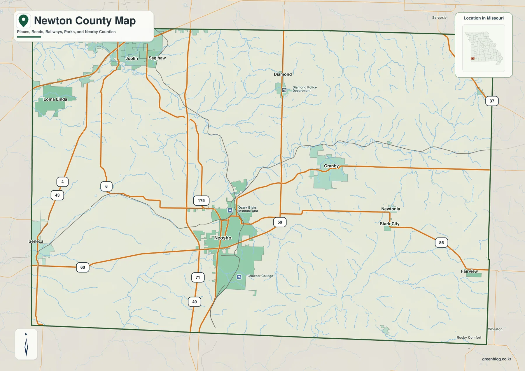
Newton County sits in the southwest corner of Missouri, where Neosho provides the clearest road reference and a dense network of Ozark streams cuts through rolling uplands. Seneca lies to the west, Granby to the east, Diamond to the north, and the southern edge of the Joplin urban area reaches the northwest side of the county. U.S. 60 crosses the county through Neosho, while U.S. 71 and Interstate 49 form a strong north-south corridor. High-resolution map files are available for download in the section below.
This page separates those features into a general county map, a city distribution map, a terrain-and-water map, and an elevation map. High-resolution JPG originals of all four can be downloaded together in one ZIP for closer inspection, A3 printing, classroom use, reports, or other large-format reference work.
Table of Contents
Neosho is the easiest place to organize the road network
Neosho sits slightly west of the county’s center and is the most useful starting point on the general map. U.S. 60 runs east-west through the area, while U.S. 71 and Interstate 49 provide the main north-south reference. Once those two directions are clear, Seneca, Granby, Diamond, and the smaller communities are much easier to place.
Following U.S. 60 west leads toward Seneca, while the eastbound route reaches the Granby side of the county and continues toward Fairview. South of Neosho, the U.S. 71/I-49 corridor heads toward the McDonald County line; northbound travel leads toward the Joplin area. The concentration of major roads around Neosho is one reason the city stands out as the county’s strongest orientation point.
Diamond lies farther north on a prominent north-south road, and Loma Linda appears in the northwest close to the Joplin side. Granby, Newtonia, and Stark City provide useful eastern references, while Route 59 and Route 86 connect smaller rural areas. Starting with the major highways and then moving to local roads keeps the map readable even where the road network becomes dense.
Seneca also provides a useful western reference near the Oklahoma side of the region. The U.S. 60 corridor between Seneca and Neosho is easy to trace, while the northwest road network becomes denser toward Loma Linda and southern Joplin. East of Granby, settlements are more widely spaced, so the map shifts from an urban-edge pattern in the northwest to a more rural pattern in the east.
Six highlighted communities spread from Seneca to Granby and Diamond
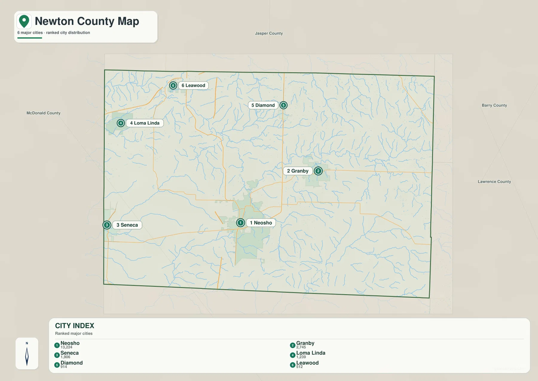
The city map highlights Neosho, Granby, Seneca, Loma Linda, Diamond, and Leawood. Neosho is ranked first and occupies the central-southwestern part of the county. Granby lies to the east, Seneca to the west, Diamond to the north, while Loma Linda and Leawood sit in the northwest near the Joplin side of the county.
The city index ranks Granby second and Seneca third, followed by Loma Linda, Diamond, and Leawood. Those rankings are useful as a quick guide to the featured places, but their positions are more important for map reading. Seneca helps identify the western U.S. 60 corridor, Granby anchors the east, and Diamond marks the northern interior.
Loma Linda and Leawood are close to the northwest county edge and are visually separated from the Neosho-centered road network. That distribution shows why Newton County cannot be understood from one town alone. Once the six highlighted places are familiar, the water and elevation maps are easier to interpret because the larger creek valleys can be placed relative to recognizable communities.
Granby and Diamond are particularly useful because they prevent the map from feeling too Neosho-centered. Granby identifies the eastern interior, while Diamond provides a northern anchor. Leawood is smaller, yet its northwest location helps define the cluster of places near the Joplin edge. Together the six labels give a quick mental framework for the county’s full east-west and north-south extent.
Shoal Creek, Lost Creek, and the Indian Creek branches cut the uplands
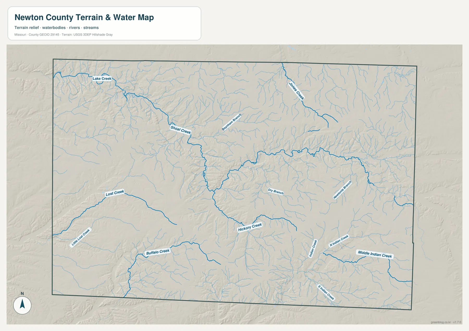
Shoal Creek is the most prominent waterway on the terrain-and-water map. It enters from the northwest near Lake Creek, bends through the interior, and receives smaller tributaries such as Bowman Branch. Jones Creek occupies a separate valley in the north-central to northeastern part of the county, creating another long low corridor through the uplands.
The southwest is organized around Lost Creek and Little Lost Creek. Buffalo Creek appears farther south, while Hickory Creek forms a strong central-southern drainage that continues eastward through the hills. These streams divide the western and central terrain into a repeating pattern of ridges and narrow valleys rather than one broad, smooth slope.
In the southeast, North Indian Creek, Middle Indian Creek, and South Indian Creek occupy separate branching valleys. Their names are related, but each follows its own corridor through the higher terrain. The map is useful for locating streams and understanding the shape of the valleys; it is not a flood map, depth chart, parcel map, navigation product, or legal water-boundary survey.
You do not need to memorize every tributary to understand the map. Shoal Creek in the northwest and center, Lost Creek in the southwest, Hickory Creek in the central-south, and the Indian Creek branches in the southeast provide a practical set of reference waterways. Smaller streams can then be read as subdivisions of those larger valley systems.
Elevation rises from about 252 to 417 meters
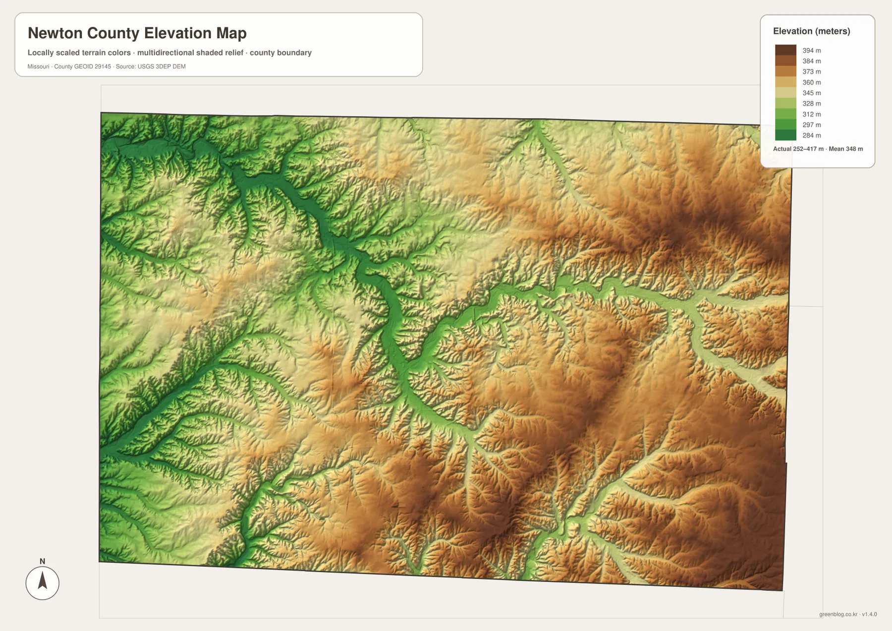
The elevation map reports an actual range of roughly 252 to 417 meters and a mean near 348 meters. The lowest greens are concentrated in the northwest and along the Shoal Creek valley, with additional low corridors following Lost Creek and other major streams. Around Neosho, the terrain repeatedly drops into stream valleys and rises onto surrounding ridges.
Higher ground covers a much larger share of the eastern and southeastern county. Brown and dark tan uplands extend east of Granby and toward the Newtonia and Fairview side, while the Indian Creek branches cut green corridors between them. The northeast also contains elevated terrain, although creek valleys such as Jones Creek create deep lower strips through the otherwise higher surface.
The southern half shows the same pattern on a finer scale: high ridges alternate with narrow valleys occupied by Buffalo Creek, Hickory Creek, and smaller tributaries. Comparing the water and elevation maps makes those relationships especially clear. The elevation surface is intended for county-scale relief comparison, not engineering, drainage construction, parcel-level elevation decisions, or survey-grade measurement.
The contrast is especially obvious between the northwest and southeast. Near the Joplin side and along Shoal Creek, green and lighter tones cover more of the map. Farther east and south, brown ridges become more common. The mean elevation of about 348 meters summarizes the county as a whole, but the color changes reveal substantial local differences between valley floors and upland crests.
Choose the map by the detail you need
Start with the general county map when roads and settlement locations matter most. Neosho, U.S. 60, and the U.S. 71/I-49 corridor provide an immediate framework, after which Seneca, Granby, and Diamond are easy to place. The city map is faster when you only need the relative positions of the six highlighted communities without every smaller road and stream.
For streams and terrain, the water map contains much more detail. Locate Shoal Creek first, then compare Lost Creek, Hickory Creek, and the Indian Creek branches before moving to the elevation map. The lower green valleys and higher brown ridges line up closely enough that the contrast between northwestern lowlands and eastern uplands becomes easy to see.
The downloadable JPG originals contain more pixels than the WebP previews embedded on the page, making them better for enlargement, A3 printing, classroom handouts, reports, and personal reference. They remain general-purpose maps, however. Legal boundaries, property ownership, live road restrictions, flood status, and precise site elevations should always be checked against the appropriate current official source.
For a printed report, the general map works well as the location overview, while the terrain-and-water map or elevation map can explain the physical setting. In classroom work, the city map provides a clean way to compare settlement positions before students move to the denser stream network. Using the maps for different questions keeps labels readable and prevents one map from carrying more information than it was designed to show.
Frequently Asked Questions
Which roads are the easiest references around Neosho?
U.S. 60 and the U.S. 71/Interstate 49 corridor are the clearest references. U.S. 60 connects the Seneca and Granby sides of the county, while U.S. 71 and I-49 run north-south through the Neosho area.
How much elevation change is shown across Newton County?
The elevation map shows an actual range of about 252 to 417 meters, with a mean near 348 meters. The northwest and Shoal Creek valley are lower, while much of the eastern and southeastern county rises onto higher uplands.
Which streams stand out on the terrain-and-water map?
Shoal Creek is the most prominent, joined by Lost Creek, Buffalo Creek, Hickory Creek, and the North, Middle, and South Indian Creek branches. Together they show how deeply streams divide the county’s rolling terrain.
Map File Information
The download ZIP contains high-resolution JPG versions of the Newton County general map, city map, terrain-and-water map, and elevation map.
- File Type: JPG
Related Maps
Sources and References
Boundary and road reference data are supported by U.S. Census Bureau TIGER/Line, water features by USGS National Hydrography, and elevation data by the USGS 3D Elevation Program. These maps are general geographic references and are not substitutes for legal surveys or current operational data.
Green Map creates custom-edited map images using open geographic data sources such as geoBoundaries, Natural Earth, OpenStreetMap, and government open data. These maps are edited visual materials, not raw data files, and are provided for education, documents, presentations, and graphic reference.