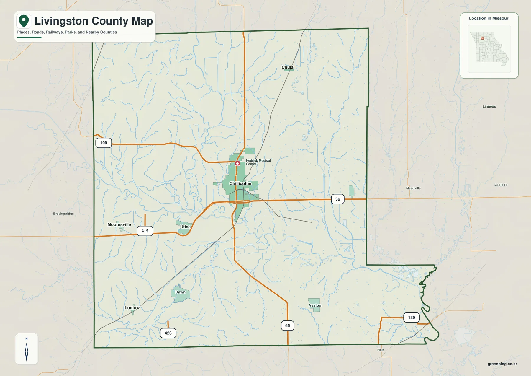
Livingston County lies in north-central Missouri, where Chillicothe serves as the dominant town and smaller communities such as Chula, Utica, Wheeling, Ludlow, and Mooresville are scattered through rolling farm country. U.S. 36 crosses the county through Chillicothe, U.S. 65 provides the main north-south route, and Routes 190, 415, 423, and 139 help orient the outer areas. Thompson River, Grand River, Muddy Creek, Medicine Creek, and many short tributaries cut long valleys through the uplands. The elevation map ranges from about 196 to 302 meters. High-resolution JPG versions of the map themes are available in the ZIP below for printing or offline use. High-resolution map files are available for download in the section below.
The county is easiest to understand by starting with Chillicothe and then comparing the river valleys on either side. Chula lies to the north, Utica and Mooresville are west, Ludlow is southwest, and Wheeling is east. Higher hills are especially prominent in the northwest and southwest, while Thompson River and Grand River create broad low corridors through the central and southern landscape.
Table of Contents
Chillicothe is the clearest road and government center
Chillicothe is the largest urban area on the general map and sits slightly south of the county’s center. U.S. 36 passes east-west through the city, and U.S. 65 provides the strongest north-south reference. Route 190 and Route 415 extend toward the western county, while U.S. 65 continues south toward Avalon and Hale.
The official Livingston County government site identifies Chillicothe as the county seat and lists the courthouse at 700 Webster Street. County offices including the Clerk, Commission, Recorder, and Treasurer are based there. That makes Chillicothe the best starting point for both geographic orientation and county services.
Chula, Utica, and Mooresville provide useful rural reference points
Chula lies north of Chillicothe near the U.S. 65 corridor and provides a reference for the northern interior. Utica is southwest of Chillicothe near Route 415, while Mooresville lies farther west. The western towns sit closer to the Thompson River drainage and lower stream corridors than many of the higher ridges in the east.
Ludlow is near the southwestern edge of the county, and Dawn appears farther east. Avalon lies in the southern interior east of U.S. 65. These small communities are useful because they give names to otherwise broad rural areas and make it easier to compare the road, water, and elevation layers.
The ranked city layer places Chillicothe far ahead of the smaller towns
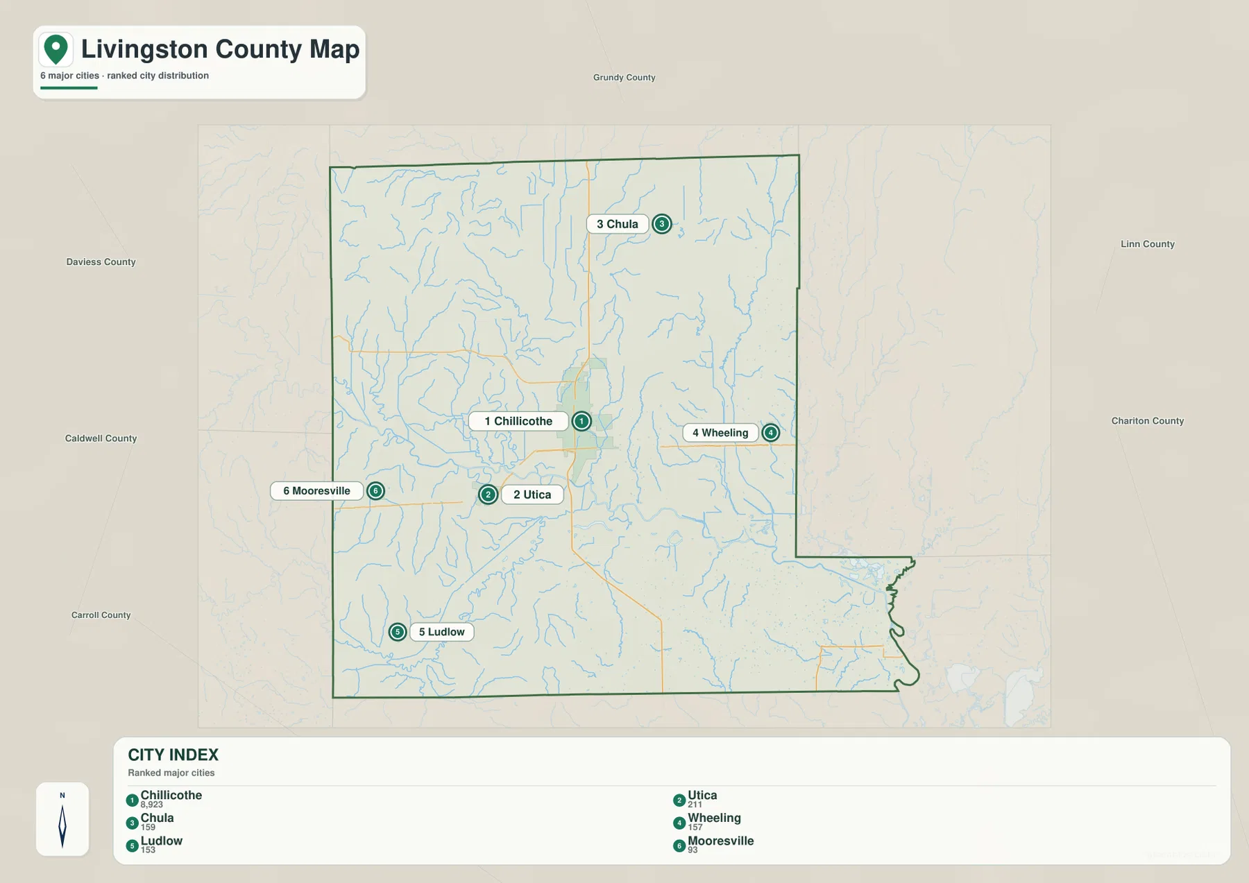
The city distribution map ranks Chillicothe first, Utica second, Chula third, Wheeling fourth, Ludlow fifth, and Mooresville sixth. The CITY INDEX values are 8,923 for Chillicothe, 211 for Utica, 159 for Chula, 157 for Wheeling, 153 for Ludlow, and 93 for Mooresville. These values belong to the supplied mapping dataset and should not be presented as current official population estimates.
The distribution pattern is more useful than the numbers. Chillicothe occupies the central-southern part of the county, while the smaller towns are spread north, east, west, and southwest. The numbered markers indicate rank only; they do not represent driving distance or travel time.
Thompson River creates a long low corridor through the west-central county
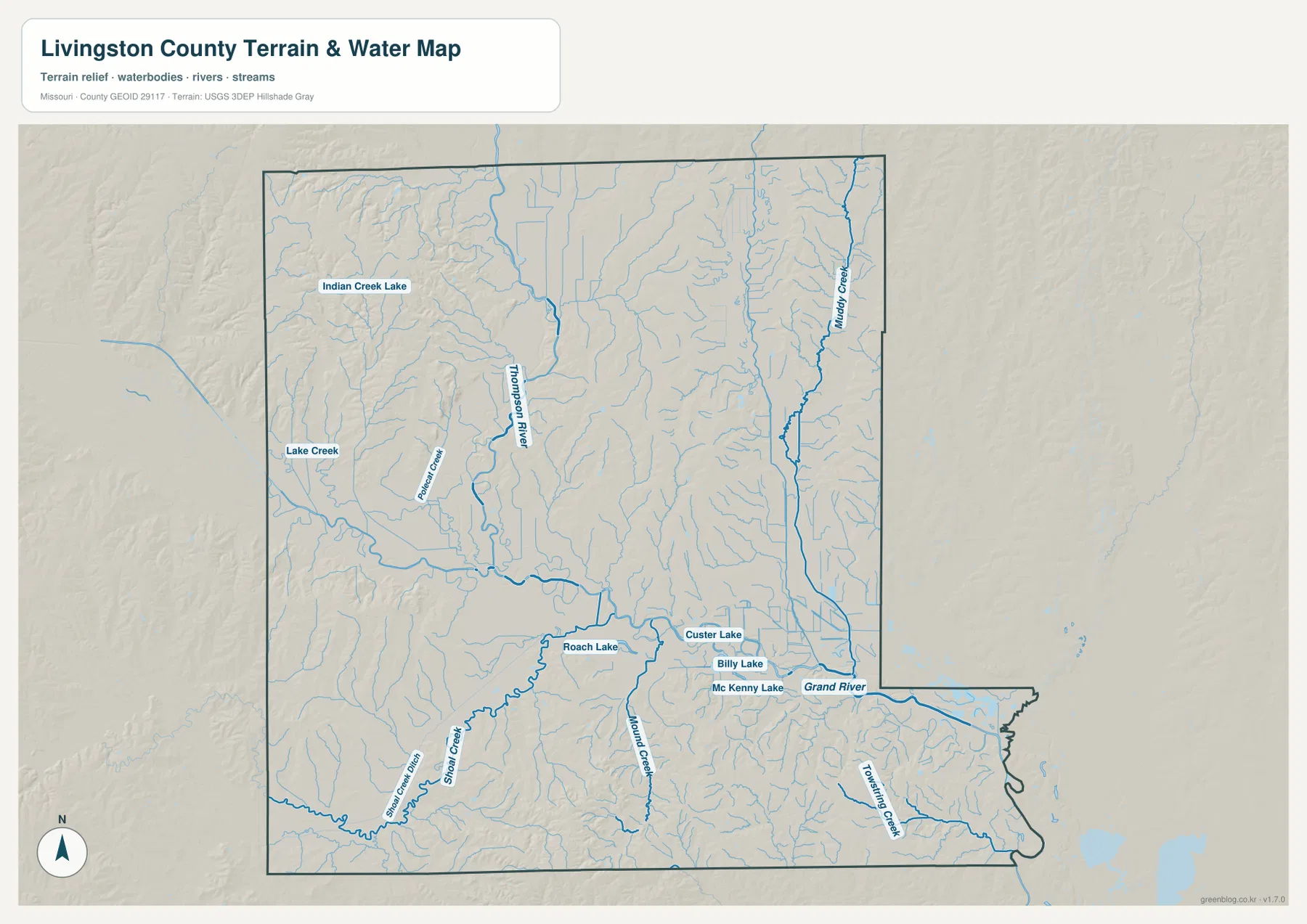
Thompson River is one of the strongest inland waterways on the terrain-and-water map. It enters from the north and continues through the west-central county before reaching the Grand River system. Numerous short tributaries join it, creating a broad valley that stands out clearly in dark green on the elevation layer.
Lake Creek appears farther west, while Indian Creek Lake is labeled in the northwestern uplands. The contrast between the low Thompson River corridor and the higher terrain to its west and east is one of the county’s most visible relief patterns. The water map is a general geographic reference rather than a live river-stage or flood-warning product.
Grand River dominates the southern drainage
Grand River crosses the southern part of Livingston County and continues toward the southeast through a broad low valley. Thompson River and several smaller tributaries feed into this larger system. Custer Lake, Billy Lake, and Mc Kenny Lake are labeled near the Grand River side and provide useful local water references.
Livingston County’s official history notes that early settlers in the late 1820s camped in timbered bottomlands between forks of the Grand River while collecting honey. The modern terrain map helps explain that historical description because the Grand River corridor remains one of the county’s broadest low areas.
Muddy Creek and Medicine Creek break up the eastern and southern uplands
Muddy Creek runs through the eastern part of the county, cutting a long valley through terrain that is otherwise relatively high. Around the Wheeling side, short tributaries feed into this drainage and create repeated narrow ridges. Medicine Creek and other southern streams descend toward the Grand River system.
Medicine Creek also appears in Livingston County historical material as a long-standing local place reference. On the elevation layer, these eastern and southern tributaries form green channels through yellow and tan uplands. That makes the water map especially useful for understanding areas that look like uniform farmland on the road layer.
Indian Creek Lake and Roach Lake provide smaller local anchors
Indian Creek Lake is labeled in the northwestern part of the terrain-and-water map, while Roach Lake appears farther south near the central drainage. Custer Lake, Billy Lake, and Mc Kenny Lake add more reference points close to the Grand River corridor.
These lakes are much smaller than the county’s river systems, but they help match rural places across the different map layers. The map should not be used to determine current water levels, private-property access, fishing regulations, or legal water boundaries; those questions require current information from the appropriate managing agency.
Elevation ranges from about 196 to 302 meters
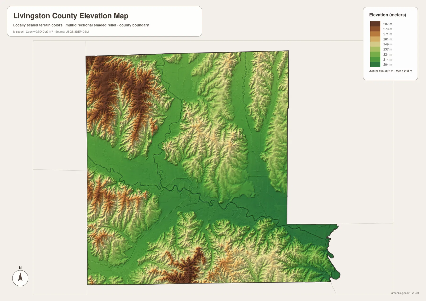
The elevation layer reports an actual mapped range of approximately 196 to 302 meters, with a mean near 233 meters. Some of the highest ground appears in the northwest and southwest, while Thompson River, Grand River, and other major stream valleys form broad low green corridors.
The county’s relief comes from streams cutting into rolling uplands rather than from isolated mountains. Chillicothe sits among moderate hills and low corridors, while the northwest toward Poosey Conservation Area becomes more rugged. The elevation map is appropriate for county-scale terrain comparison but should not be used as survey-grade or engineering-grade elevation data.
Poosey Conservation Area shows the rugged side of northwestern Livingston County
Poosey Conservation Area lies in northwestern Livingston County and extends into neighboring Grundy County. Missouri Department of Conservation describes a landscape of timbered oak-hickory hills, rolling grasslands, rock bluffs, and diverse wildlife habitat. The current area covers 5,863 acres.
Indian Creek Community Lake, a 192-acre impoundment, is one of the best-known water features in the conservation area. Its location provides a useful real-world connection to the Indian Creek Lake label in the county’s northwestern water map. The mix of ridges, lake, and valleys also matches the stronger relief shown in this corner of the elevation layer.
Chillicothe is also known as the Home of Sliced Bread
Livingston County’s official visitor page promotes Chillicothe as the ‘Home of Sliced Bread,’ a local identity that has become closely associated with the community. The title gives the county seat a cultural role in addition to its administrative and transportation functions.
County historical material states that Livingston County was created in 1837 and named for Edward Livingston, who served as U.S. Secretary of State under President Andrew Jackson. The current courthouse was completed in 1914. Those facts add historical context to the city that dominates the supplied road and city maps.
Choosing the right downloadable map
Use the general county map for Chillicothe, the smaller towns, and the main roads. The ranked city layer is best for comparing Chillicothe, Utica, Chula, Wheeling, Ludlow, and Mooresville. The terrain-and-water map is useful for Thompson River, Grand River, Muddy Creek, local lakes, and tributaries, while the elevation map makes the contrast between high ridges and low river corridors easiest to see.
The ZIP contains A3 high-resolution JPG files matching the map themes shown on the page. They are useful when labels need to be enlarged or when a printed reference is more convenient. These files do not replace live navigation, flood warnings, legal property boundaries, or professional elevation surveys.
Frequently Asked Questions
What is the best starting point for reading a Livingston County map?
Chillicothe is the clearest starting point because it is the county seat and the main road center, with U.S. 36 and U.S. 65 providing strong references. From there, Chula, Utica, Wheeling, Ludlow, and Mooresville are easy to orient.
Are the CITY INDEX values current population figures?
No. The values shown for Chillicothe, Utica, Chula, Wheeling, Ludlow, and Mooresville belong to the supplied mapping dataset. Current official population estimates should be checked separately with the U.S. Census Bureau or another current statistical source.
Where is the lowest terrain in Livingston County?
The supplied elevation map shows the Thompson River and Grand River corridors among the broadest low areas. The northwest and southwest contain higher hills, and the full mapped elevation range is about 196 to 302 meters.
Map File Information
Download the map files associated with this page for reference, printing, and compatible visual projects.
- Included Files: Use only the versions confirmed in the article and supplied images
- File Type: Use the confirmed download contents
- Intended Use: Printing, education, presentations, and map-based projects
Related Maps
Sources and references
- Livingston County, Missouri – Official Website – county government and courthouse information in Chillicothe
- Livingston County – History – county organization and local history
- Livingston County – Visitors – Chillicothe and Home of Sliced Bread information
- Missouri Department of Conservation – Poosey Conservation Area – northwestern hills, forests, and Indian Creek Lake context
- U.S. Census Bureau TIGER/Line Shapefiles – county boundary and road data
- USGS National Hydrography – rivers, streams, and water features
- USGS 3D Elevation Program – elevation data
Green Map creates custom-edited map images using open geographic data sources such as geoBoundaries, Natural Earth, OpenStreetMap, and government open data. These maps are edited visual materials, not raw data files, and are provided for education, documents, presentations, and graphic reference.