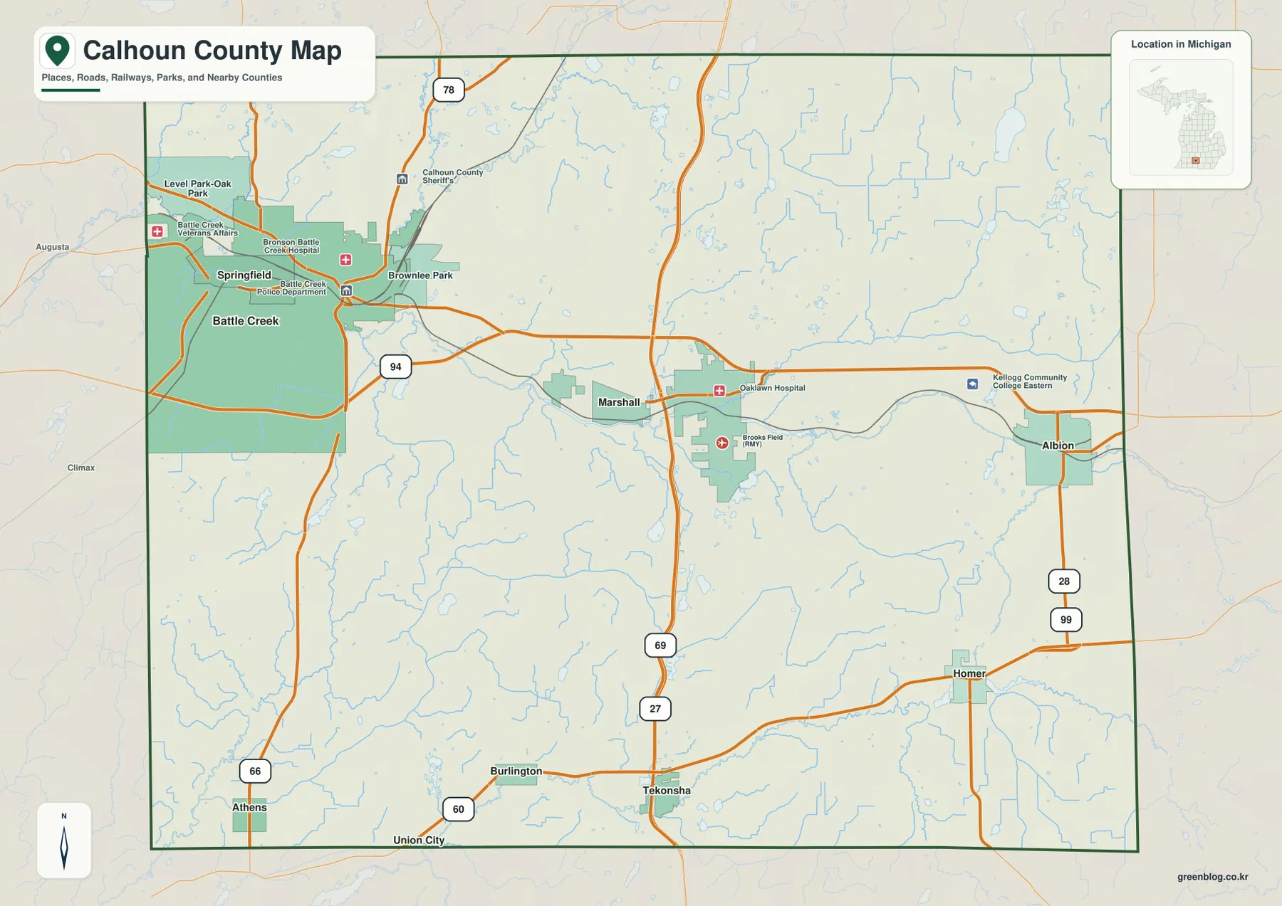
Howard County lies in central Missouri, where Fayette provides the clearest interior reference and the Missouri River wraps around much of the western and southern edge. Glasgow sits near the river in the northwest, New Franklin occupies the southern side, and Armstrong is farther north. Between those communities, deeply branching streams such as Bonne Femme Creek, Moniteau Creek, Sulphur Creek, and Hungry Mother Creek cut the uplands into long ridges and narrow valleys. This page compares the road network, ranked communities, water features, and an elevation range of roughly 174 to 277 meters. High-resolution JPG versions of the map themes are available together in the ZIP for printing or offline use. High-resolution map files are available for download in the section below.
The county becomes easier to understand when Fayette is used as the central anchor. Route 240 connects Fayette toward Glasgow, Route 5 runs south toward New Franklin, and Route 3 continues north toward Armstrong. The Missouri River bottoms are broad and low, but the interior rises quickly into dissected hills, so moving only a short distance away from the river can produce a very different terrain pattern.
Table of Contents
Fayette and Routes 240 and 5 organize the county interior
Fayette is the most prominent town on the general county map and lies near the middle of Howard County. Route 240 and Route 5 meet in the area, while Route 3 continues north toward Armstrong. Route 124 appears along the eastern side, and Routes 187 and 87 provide useful references closer to the southwestern river country. The road network spreads outward from Fayette but repeatedly bends as it crosses creek valleys and higher ridges.
The general map also shows how quickly rural drainage lines approach the town. This is not a flat grid of roads. Local routes adjust to valleys, uplands, and the approaches to the Missouri River. For current traffic and turn-by-turn travel, a live navigation source is still necessary, but this map is useful for understanding how the major towns and highways fit together.
Glasgow and New Franklin sit at opposite parts of the Missouri River edge
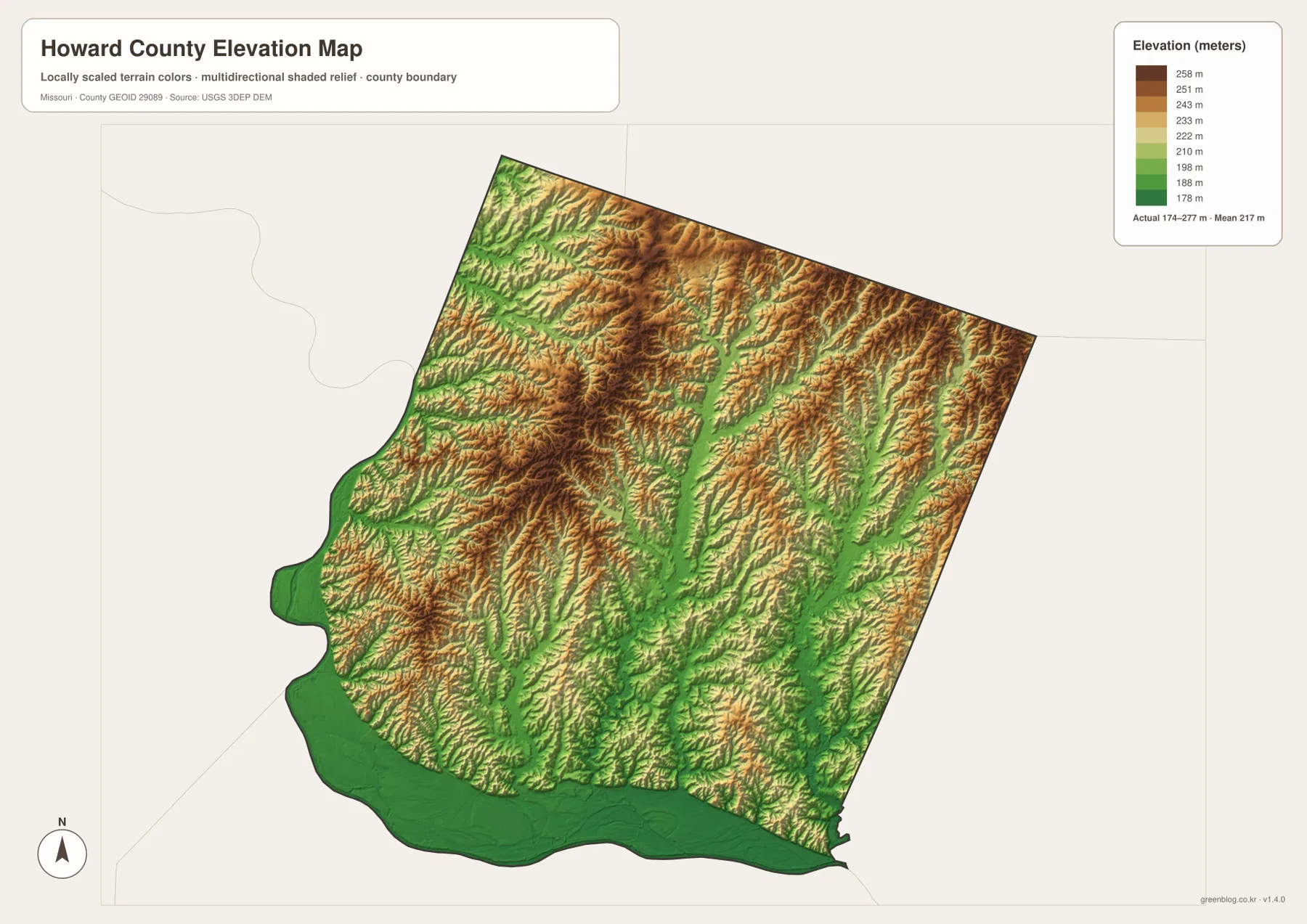
Glasgow lies in the northwestern part of Howard County beside a large bend of the Missouri River. Route 240 links the river town with Fayette farther inland. On the elevation layer, the river corridor around Glasgow appears as a broad low green area, while the ground to the east and southeast becomes more deeply cut by tributaries and higher ridges.
New Franklin occupies the southern side of the county where Missouri River bottomland meets the interior hills. Route 5 and nearby Routes 87 and 40 help locate the town. The supplied city dataset also labels Franklin separately near New Franklin, so the two names should not be merged when reading the city map. The southern landscape changes quickly from flat river bottom to incised upland terrain.
The city layer ranks five major communities
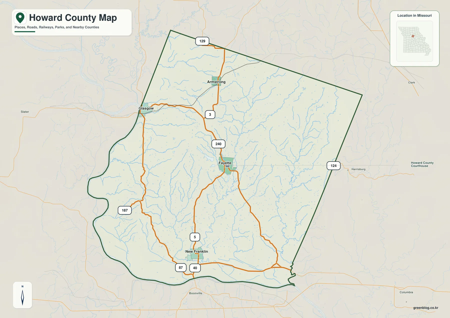
The ranked city map places Fayette first, New Franklin second, Glasgow third, Armstrong fourth, and Franklin fifth. The CITY INDEX displays values of 2,801 for Fayette, 2,170 for New Franklin, 1,118 for Glasgow, 416 for Armstrong, and 66 for Franklin. These values belong to the map’s ranking dataset and should not be treated as claims about the latest official population totals.
The distribution itself is more useful than the raw numbers. Fayette occupies the center, New Franklin lies south, Glasgow is northwest, Armstrong is north, and Franklin is shown near the southern river country. The numbered markers are ranking labels rather than road mileage or travel-time measurements.
Bonne Femme Creek cuts a deep central valley
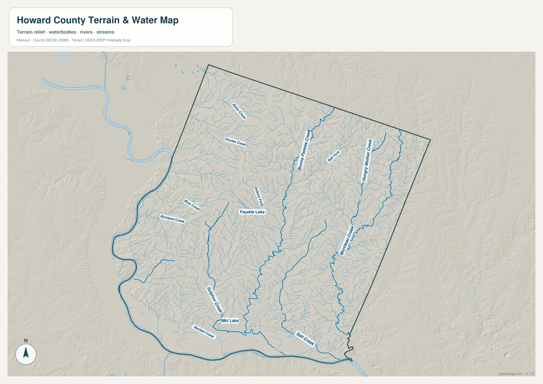
Bonne Femme Creek is one of the strongest drainage features on the terrain-and-water map. Its valley extends through the north-central interior and continues south of the Fayette area, receiving many short tributaries from both sides. On the elevation layer, the creek forms a long green corridor bordered by tan and brown ridges.
Adams Fork and Fayette Lake provide additional references west of the main Bonne Femme drainage. Richland Creek lies farther west, and Doxies Creek is labeled in the northwestern uplands. Together, these waterways show why the interior road pattern is irregular: the land is divided into many narrow ridges rather than one broad flat surface.
Moniteau Creek and Hungry Mother Creek shape the eastern half
Moniteau Creek runs through much of the eastern half of Howard County and creates one of the longest low corridors on the map. Hungry Mother Creek occupies a separate northeastern valley, while a network of short tributaries drains the ridges between them. The eastern uplands are therefore highly dissected even where the general road map looks relatively open.
Salt Fork and Salt Creek add useful references farther south and east. On the elevation layer, those channels are green while the ridges between them rise sharply into warmer colors. The terrain-and-water layer is intended for geographic reference rather than real-time flood conditions, legal parcel boundaries, or navigation.
Sulphur Creek descends toward the southern Missouri River bottom
Sulphur Creek runs south from the interior toward the low country west of New Franklin. Bartlett Creek joins the same general southern drainage area, and the land opens into the broad Missouri River bottom near the county’s southern edge. This transition from narrow creek valley to flat river lowland is one of the clearest terrain changes in the county.
The Missouri River also forms much of the western boundary, producing another long strip of low ground below the interior hills. Glasgow and New Franklin are both close to that river environment, yet the land between them is crossed by many tributaries and ridges. The result is a county where river-bottom terrain and rolling uplands sit very close together.
Elevation ranges from about 174 to 277 meters
The elevation layer reports an actual mapped range of approximately 174 to 277 meters, with a mean near 217 meters. The lowest terrain follows the Missouri River along the west and south and also appears in the larger creek valleys. Higher ground occupies much of the north and central interior, where long ridges appear in tan and brown.
Howard County’s relief is created less by a single major highland than by the repeated incision of streams into rolling uplands. Bonne Femme Creek and Moniteau Creek form long low corridors, while narrow ridges remain between tributaries. This map is suitable for broad county-scale terrain comparison and should not be treated as survey-grade or engineering-grade elevation data.
Boone’s Lick history connects the landscape with early Missouri travel
Howard County is closely associated with the historic Boone’s Lick Country. Missouri State Parks identifies Boone’s Lick State Historic Site near Boonesboro in Howard County and explains that Nathan and Daniel Morgan Boone developed commercial salt production at the springs in the early 1800s. Salt from the works was shipped by keelboat on the Missouri River to St. Louis.
That history gives added context to the map. The Missouri River provided a major transportation route, while the county’s interior contains names such as Salt Creek and Salt Fork. The maps do not reconstruct historic roads or industrial sites, but the river, creek valleys, and rolling uplands help explain why this part of central Missouri became important to early settlement and trade.
Fayette remains the practical center for county services
University of Missouri Extension maintains its Howard County office at 600 W Morrison in Fayette and provides agriculture, 4-H, and community resources. This current public-service location matches Fayette’s central position on the map.
The Missouri Secretary of State’s 2025–2026 Blue Book also identifies Fayette as the Howard County seat. Readers who need current government contacts, office hours, or local services can use the map for geographic context and then consult the relevant official page for the latest details.
Choosing the most useful downloadable map
The general county map is the best starting point for towns and highways. The ranked city map provides a quick comparison of Fayette, New Franklin, Glasgow, Armstrong, and Franklin. The terrain-and-water layer is more useful for Bonne Femme Creek, Moniteau Creek, Sulphur Creek, and the Missouri River lowlands, while the elevation layer shows the sharp contrast between those valleys and the higher interior ridges.
The download ZIP contains high-resolution JPG versions of the same map themes shown on the page. They are useful for enlarging labels, printing a reference sheet, or comparing layers side by side. The files are intended for general geographic reference and do not replace live navigation, flood warnings, legal boundary surveys, or professional elevation measurements.
Frequently Asked Questions
What is the easiest place to use as a reference in Howard County?
Fayette is the clearest starting point. It lies near the center of the county, with Routes 240 and 5 nearby, and provides an easy reference for Glasgow, New Franklin, and Armstrong.
Do the numbers on the city map show driving distance?
No. They rank Fayette, New Franklin, Glasgow, Armstrong, and Franklin within the supplied city dataset. The markers and CITY INDEX values are not road mileage or travel times.
Where is the lowest terrain in Howard County?
On the supplied elevation map, the broadest low terrain follows the Missouri River along the western and southern edges. Major valleys such as Bonne Femme Creek and Moniteau Creek also form lower green corridors through the interior.
Map File Information
Download the map files associated with this page for reference, printing, and compatible visual projects.
- Included Files: Use only the versions confirmed in the article and supplied images
- File Type: Use the confirmed download contents
- Intended Use: Printing, education, presentations, and map-based projects
Related Maps
Sources and references
- University of Missouri Extension – Howard County – Fayette county office and local public programs
- Missouri State Parks – Boone’s Lick State Historic Site – Howard County saltworks and Boone’s Lick history
- Missouri Secretary of State – 2025–2026 Blue Book – Howard County and Fayette administrative information
- U.S. Census Bureau TIGER/Line Shapefiles – county boundary and road data
- USGS National Hydrography – rivers, streams, and water features
- USGS 3D Elevation Program – elevation data
Green Map creates custom-edited map images using open geographic data sources such as geoBoundaries, Natural Earth, OpenStreetMap, and government open data. These maps are edited visual materials, not raw data files, and are provided for education, documents, presentations, and graphic reference.