Dent County sits in Missouri’s Ozark country, where Salem provides the clearest urban reference and a dense network of streams divides the surrounding uplands into ridges and valleys. The general map is useful for locating Salem and the major road corridors, while the terrain-and-water layer brings the Meramec River, Current River, Dry Fork, Spring Creek, and many smaller tributaries into view. The elevation layer adds another dimension by showing a mapped range of roughly 250 to 444 meters. High-resolution JPG versions of all four map themes are included in the download ZIP for printing and offline reference.
The county outline is irregular, especially along the eastern and southern sides, and the landscape becomes much more rugged away from Salem. Roads curve through long valleys and around higher ground rather than forming a dense urban grid. That makes Dent County a place where road, water, and elevation information work especially well together. Start with Salem on the general map, then follow a route toward the Meramec or Current river systems and compare the same area on the water and elevation maps.
Table of Contents
Salem is the main reference point
Salem is the most prominent community on the county map and lies slightly north of the county’s middle. Salem Memorial District Hospital is labeled near the city, making the urban area easy to identify. Route 19 continues south from Salem, Route 32 runs east, and Routes 68 and 72 help orient the northern and northwestern portions of the county. These numbered roads are the most practical starting points for comparing Salem with more remote parts of Dent County.
Away from Salem, the network becomes increasingly rural. The map also shows local road numbers such as 117, 233, 404, 406, 421, 438, 524, 554, 561, and 624. Many of these roads bend with the terrain rather than following long straight lines. A live navigation service is still necessary for current routing, but the county map clearly shows how Salem sits within the road network and how travel corridors spread into the surrounding Ozark hills.
The ranked city map highlights only Salem
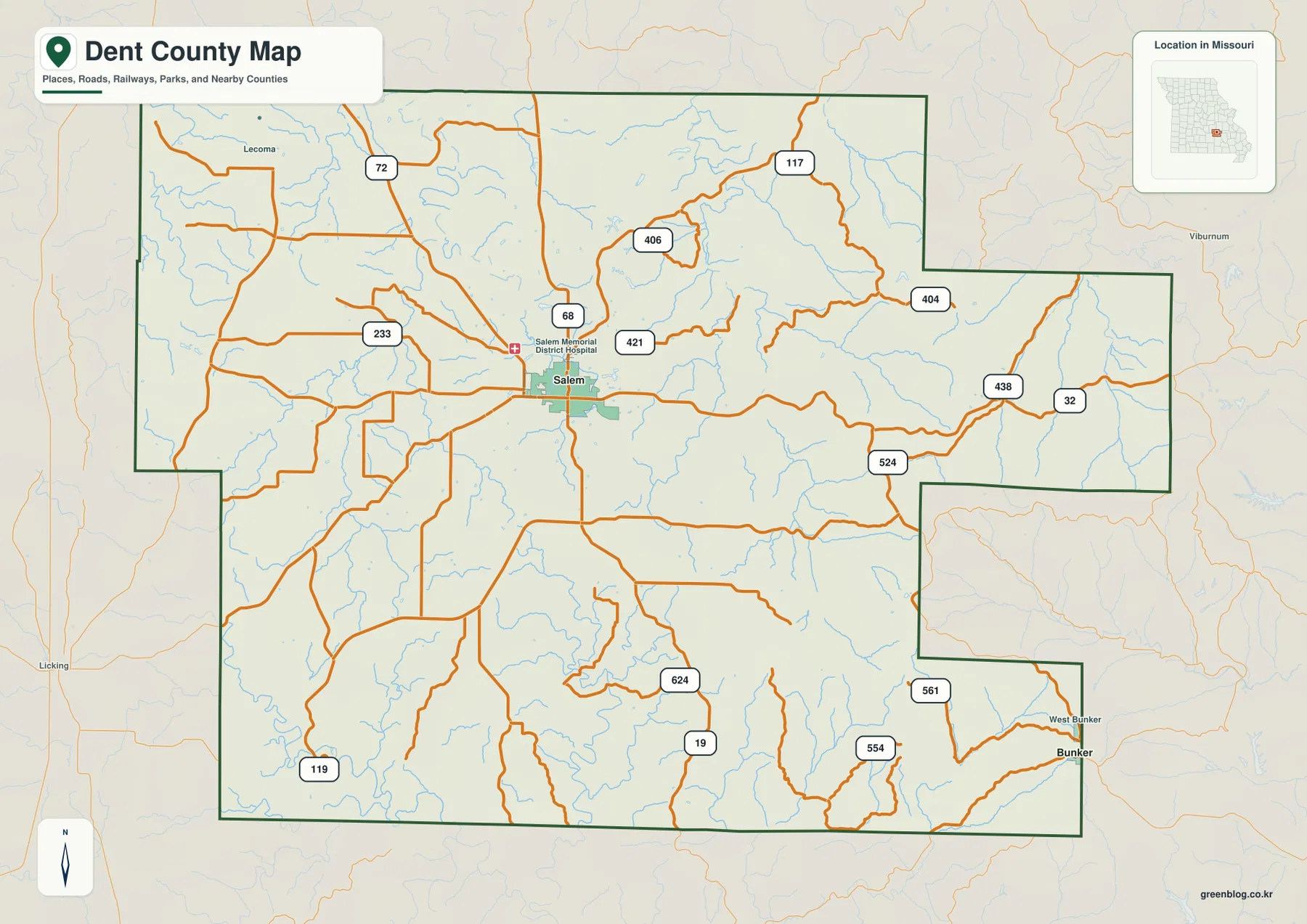
The city distribution layer is unusual compared with many county maps in this series because it contains only one ranked major city. Salem is marked as number 1, and the CITY INDEX displays Salem with a value of 4,677. That figure should be read as the value attached to this map’s city-ranking dataset rather than as a claim about the latest official population estimate. Current demographic figures should be checked in an up-to-date census source.
A one-city distribution map is still useful. It makes clear that Salem is the county’s dominant urban reference without implying that Dent County lacks smaller communities, rural settlements, or named places. The general map and GNIS-based place resources contain additional names, but this layer intentionally simplifies the settlement picture. The Missouri Association of Counties also lists several Dent County administrative offices at Salem addresses, reinforcing Salem’s practical importance when looking up county services.
The Meramec River defines a major northeastern valley
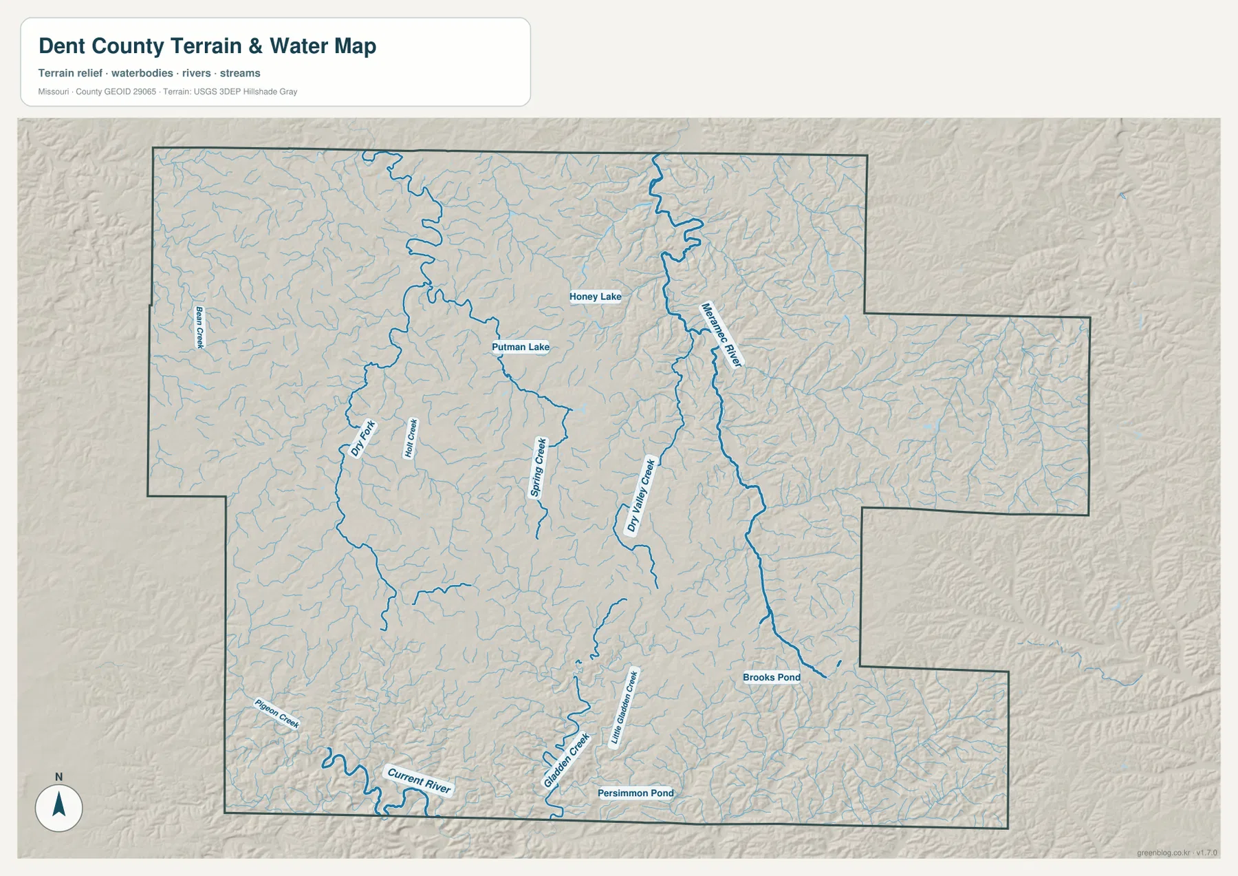
One of the strongest water features on the terrain-and-water map is the Meramec River. It winds through the northeastern part of Dent County and receives numerous small tributaries from the surrounding hills. On the elevation map, the same corridor appears as a lower green valley bordered by higher ridges. Comparing the two layers makes the topography much easier to understand: the river occupies low ground, while the surrounding uplands rise sharply enough to create a clearly dissected Ozark landscape.
West of the Meramec, Dry Valley Creek follows another long valley and Spring Creek appears farther west. Dry Fork is a prominent stream in the northwestern half of the county, with smaller channels such as Holt Creek and Bangs Creek nearby. These waterways do not cross a broad flat plain. They occupy separate valleys divided by ridges, which explains the close spacing of streams and the irregular road patterns seen on the general map.
The Current River marks the southern low country
The Current River appears along the southern edge of the mapped county area, curving through some of the lowest terrain shown on the elevation layer. Deep green shading follows the river valley, while tan and brown uplands rise immediately to the north. The contrast is one of the clearest examples of Dent County’s relief. USGS maintains a Current River monitoring location at Montauk State Park in Dent County, providing an official reference for the river’s location and hydrologic setting.
North of the Current River, Gladden Creek and Little Gladden Creek cut through the southern uplands. Pigeon Creek is labeled farther west. The area is filled with many smaller channels, producing a fine branching pattern that stands out on the terrain-and-water map. These maps are geographic references rather than flood forecasts or fishing-regulation guides, so anyone needing current water levels, warnings, or regulations should consult USGS or the Missouri Department of Conservation directly.
Small lakes and ponds add useful local landmarks
The water layer also names Honey Lake, Putman Lake, Brooks Pond, and Persimmon Pond. Honey Lake and Putman Lake lie north and northeast of Salem among the upper tributaries. Brooks Pond appears in the southeastern portion of the county, while Persimmon Pond is close to the southern edge. They are much smaller than the Meramec and Current rivers, but their labels are useful for matching a local area across the different map layers.
Once one of these water bodies is located, the nearby relief becomes easier to recognize. Putman Lake sits among tributaries near Spring Creek, and Honey Lake lies west of the Meramec River valley. Brooks Pond and Persimmon Pond are surrounded by the more deeply dissected terrain of southern Dent County. Using a named pond or lake as a fixed landmark can make the dense network of creeks and ridges less confusing.
Elevation ranges from about 250 to 444 meters
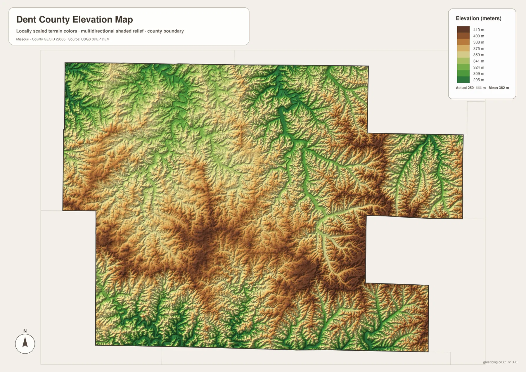
The elevation map reports an actual mapped range of approximately 250 to 444 meters, with a mean near 362 meters. Lower elevations follow the major rivers and many tributary valleys, while higher ground appears on the ridges between them. This is not a landscape dominated by one isolated peak. Instead, Dent County contains repeated bands of higher and lower ground created by a dense stream network cutting through the Ozark uplands.
The southern and eastern portions show especially strong relief because narrow green valleys are packed between tan and brown ridges. The central and western areas also contain substantial high ground, but streams such as Dry Fork, Spring Creek, and Dry Valley Creek carve long lower corridors through it. Along the Meramec River, the low valley is particularly easy to trace. Near the Current River, the branching pattern becomes even more intricate as tributaries enter from the north.
Salem to the east: roads meet the Meramec drainage
Salem sits on comparatively open ground when viewed at county scale, but the terrain changes quickly toward the east. Route 32 crosses a landscape cut by tributaries leading toward the Meramec River. The road map shows bends and junctions; the water map explains many of those bends by revealing the valleys, and the elevation layer shows the higher ridges between them. Looking at all three views turns a simple road line into a much clearer picture of the land it crosses.
The eastern side of Dent County is also where the irregular county boundary becomes noticeable. Streams continue across the surrounding landscape even where the administrative line changes direction. That is a useful reminder that county boundaries organize government and mapping, while rivers and ridges follow natural terrain. Readers interested in nearby counties can use the boundary labels on the general map and then compare the same river valleys beyond Dent County.
Salem to the south: Route 19 enters rougher terrain
Route 19 provides the clearest north-south reference from Salem into the southern half of the county. As the road continues south, urban labels become sparse and the map is increasingly dominated by streams, local roads, and ridges. The Current River and the Gladden Creek system become important natural landmarks near the southern edge. This part of Dent County is a good example of why the map set includes both transportation and terrain layers.
A reader can start at Salem, follow Route 19 south on the general map, then switch to the elevation layer to see the ridge-and-valley pattern along the route. The water layer adds the creeks that occupy many of those valleys. The result is a more complete geographic picture than any one map can provide on its own, especially in an Ozark county where elevation changes and stream valleys strongly influence the appearance of the road network.
How the four map layers complement one another
The general county map is best for Salem, numbered roads, the county boundary, and broad orientation. The ranked city map strips that information down to one major urban point—Salem. The terrain-and-water layer adds named rivers, creeks, lakes, and ponds. The elevation layer shows why those waterways occupy narrow valleys and why adjacent ridges stand higher. Because every layer uses the same county outline, a place found on one map can be followed across the others.
A practical example is the Meramec River. Find Salem first, move northeast on the general map, then use the water layer to locate Dry Valley Creek and the Meramec channel. The elevation map shows that the same corridor is lower than the surrounding land. The same process works in the south with Route 19, Gladden Creek, and the Current River. Repeating the exercise with two or three locations is often the fastest way to understand Dent County’s overall geography.
Using the downloadable JPG map files
The ZIP contains high-resolution JPG versions of the general county map, ranked city map, terrain-and-water map, and elevation map. The WebP images embedded in the page are efficient for quick viewing, while the JPG files are more convenient for enlarging road labels, printing a reference sheet, or placing a map into a personal research document. Keeping all four files together also makes side-by-side comparison much easier.
Use the general map when roads and place names are the priority. Open the city map when you want the simplest possible view of Salem’s position. Choose the water map for the Meramec, Current, Dry Fork, Spring Creek, and local water bodies, and use the elevation layer to compare valley floors with the surrounding uplands. These files are intended for general geographic reference and should not replace legal boundary surveys, live navigation, emergency warnings, or current hydrologic guidance.
Public sources for Dent County
The Missouri Association of Counties provides a Dent County page with county office contacts and Salem addresses, making it a useful public reference for local administration. University of Missouri Extension also maintains a Dent County office in Salem and publishes county-specific educational resources. These sources complement the map by connecting the central city label with real public services.
For physical geography, the USGS Current River at Montauk State Park monitoring page identifies the station as being in Dent County and provides location and hydrologic information. Boundary and road data can be checked through U.S. Census Bureau TIGER/Line resources, water features through USGS National Hydrography, and elevation through the USGS 3D Elevation Program. These official sources are appropriate when more detail is needed than a general county map can provide.
Frequently Asked Questions
What is the easiest place to use as a reference in Dent County?
Salem is the clearest starting point. It is the only ranked major city on the city layer and sits near several important roads, including Routes 19 and 32.
Why does the city map show only Salem?
The ranked city layer contains only one major city entry for this county. That does not mean there are no other named communities or rural settlements; it simply reflects the ranking dataset used for this map.
What elevation range does the Dent County map show?
The elevation layer shows an actual range of about 250 to 444 meters, with a mean near 362 meters. Major river and creek valleys are lower, while the surrounding Ozark ridges rise higher.
Map File Information
Download the map files associated with this page for reference, printing, and compatible visual projects.
- Included Files: Use only the versions confirmed in the article and supplied images
- File Type: Use the confirmed download contents
- Intended Use: Printing, education, presentations, and map-based projects
Related Maps
Sources and references
- Missouri Association of Counties – Dent County – county offices and Salem contact information
- University of Missouri Extension – Dent County – county office and local educational resources
- USGS – Current River at Montauk State Park – an official Current River monitoring location in Dent County
- U.S. Census Bureau TIGER/Line Shapefiles – boundary and road data
- USGS National Hydrography – rivers, streams, and water features
- USGS 3D Elevation Program – elevation data
Green Map creates custom-edited map images using open geographic data sources such as geoBoundaries, Natural Earth, OpenStreetMap, and government open data. These maps are edited visual materials, not raw data files, and are provided for education, documents, presentations, and graphic reference.