Daviess County in northwestern Missouri is a rural county of small towns, broad farm country, winding streams, and rolling ground. Gallatin is the most practical place to begin, but the map set also makes it easy to locate Jamesport, Gilman City, Pattonsburg, Winston, Altamont, Lake Viking, and several smaller communities. The page combines roads, settlement locations, water features, and elevation so readers can compare the same county from several useful viewpoints. High-resolution JPG versions of the maps are also available together in one ZIP for printing or offline reference. High-resolution map files are available for download in the section below.
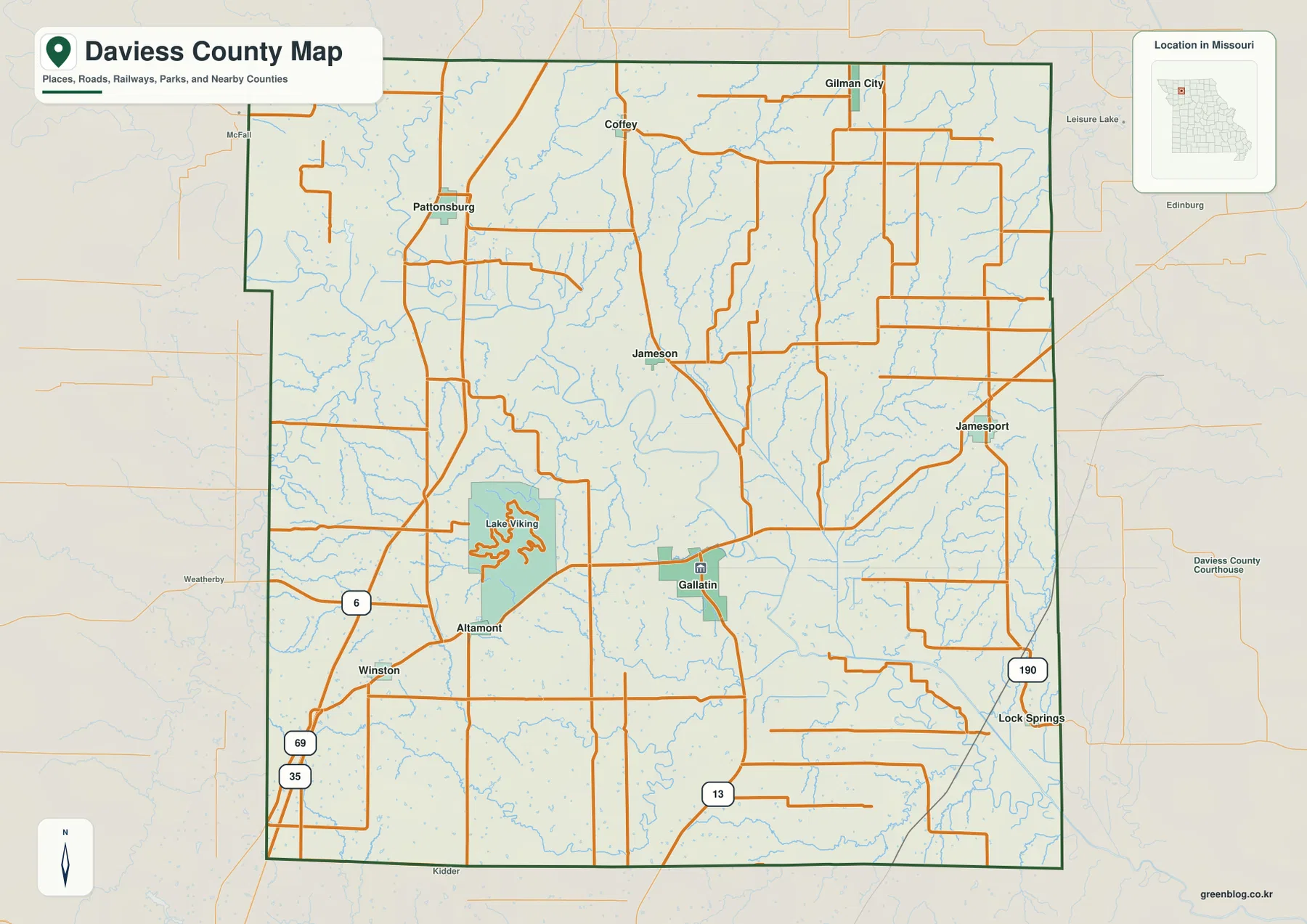
A quick look at the county map shows how widely separated the main communities are. Gallatin sits in the southern half, Jamesport lies well to the east, Pattonsburg occupies the northwest, and Gilman City is close to the northern edge. Winston and Altamont are grouped more closely in the southwest, while Lake Viking sits just to their northeast. Those positions become much easier to remember once the road network and the Grand River corridor are added to the picture.
Table of Contents
Gallatin is the clearest starting point
Gallatin is marked with the Daviess County Courthouse and works well as the county’s main map reference. Route 13 passes through the area and continues north, while Jamesport lies to the east and Altamont and Winston sit to the southwest. Farther west, U.S. 69 and I-35 give readers another strong north-south reference. The result is a map where the direction of each community can be understood without treating every local road as equally important.
Pattonsburg appears in the northwest near Route 6. Gilman City and Coffey occupy the northern part of the county, Jameson lies between Gallatin and the north, and Lock Springs is closer to the eastern side. The map is intended for county-scale orientation rather than live navigation. Current construction, closures, and turn-by-turn driving information should be checked with a current road service.
Six highlighted communities show the county’s spread
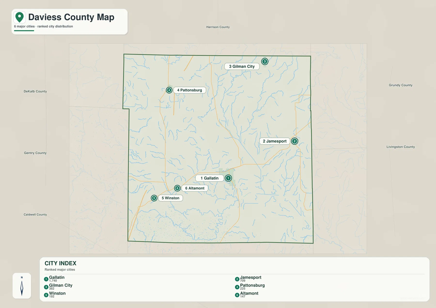
The city map ranks six communities: Gallatin first, Jamesport second, Gilman City third, Pattonsburg fourth, Winston fifth, and Altamont sixth. The numbers are identification ranks, not road mileage or travel-time measurements. Gallatin and Jamesport occupy different parts of the southern and eastern county, while Gilman City and Pattonsburg are separated across the north. The layout immediately shows that the county’s major communities do not form one continuous urban corridor.
Winston and Altamont are a relatively close pair in the southwest, but Jamesport is much farther east. Gallatin sits between several of these directions without being geographically close to every place. That distribution makes the city map useful as a simple index. Readers can identify the six highlighted communities first and then return to the general map for more roads, smaller place names, and Lake Viking.
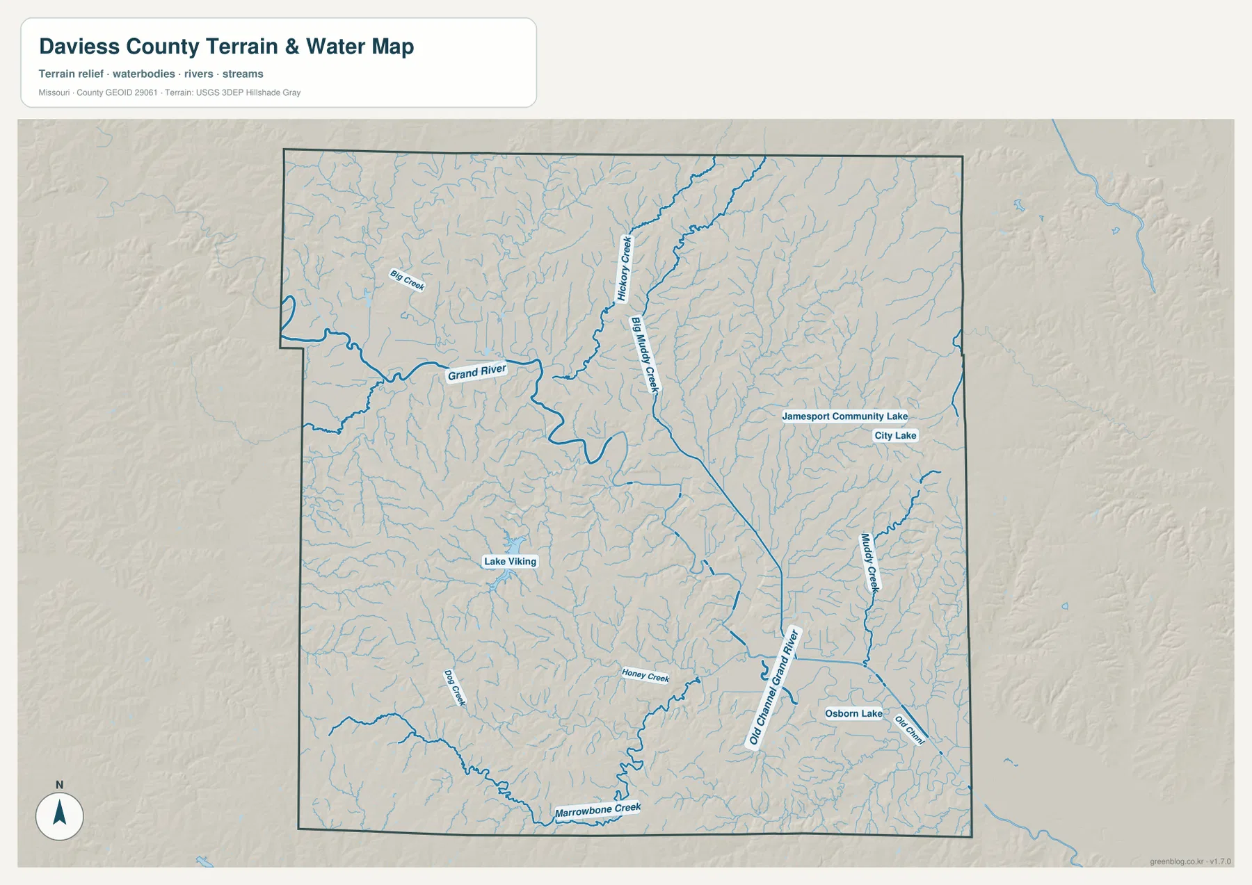
The Grand River defines the main low corridor
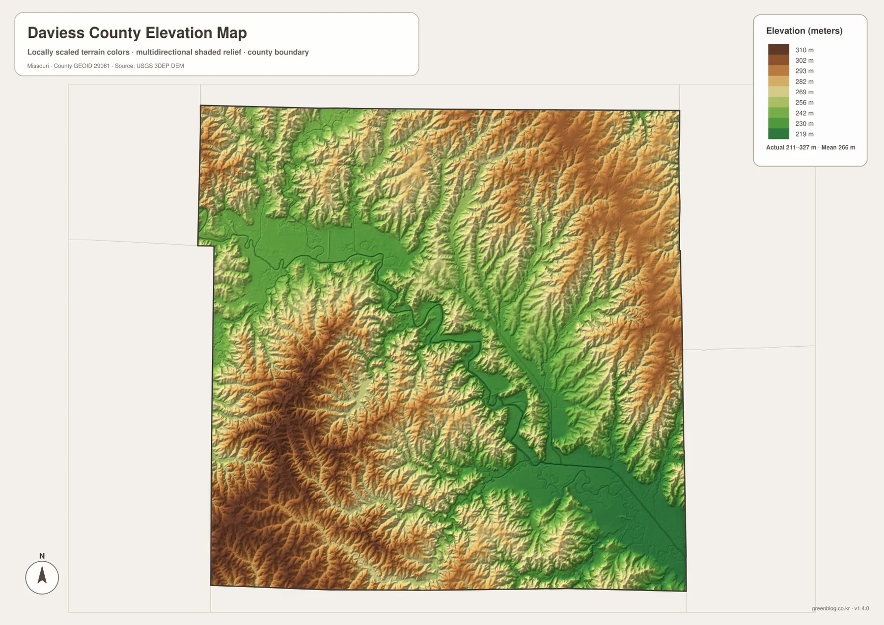
The Grand River is the largest named water feature on the map. It enters from the northwest, bends through the interior, and continues toward the southeast. Several tributaries join it along the way, producing a broad low corridor that is also clear on the elevation layer. The river valley appears in lower green tones, while the land between the drainage lines rises into rolling uplands.
Old Channel Grand River is labeled in the southeastern part of the county. That name helps show that the broader river valley is more complicated than a single present-day channel. Small tributaries feed into the valley from both sides, and the lower ground widens and narrows as it crosses the county. This relationship between the river and the surrounding relief is one of the most distinctive geographic features of the map set.
Big Muddy Creek, Hickory Creek, and eastern tributaries
Hickory Creek and Big Muddy Creek cross the northern part of the county, while Big Creek is labeled toward the northwest. Muddy Creek is prominent on the eastern side, and Dog Creek and Honey Creek appear farther south and west. Near the southern boundary, Marrowbone Creek adds another named valley. Many smaller blue lines connect these features, showing that the county is divided by far more drainage channels than the road map alone suggests.
These water features are useful landmarks, but the map is not a flood-risk product, a parcel map, or a navigation chart. A creek line can help readers understand why a valley is low or why two ridges are separated, but it should not be used to determine current flood danger or legal boundaries. Those questions require current official information from the appropriate local, state, or federal agency.
Lake Viking anchors the southwestern part of the county
Lake Viking lies west of Gallatin and north of Altamont, making it one of the easiest landmarks for the southwestern portion of Daviess County. Its outline is visible on the general map, and the water map places it among the smaller surrounding streams. When Gallatin, Winston, and Altamont are compared with the lake, their relative positions become much easier to remember.
Several smaller lakes are labeled elsewhere. Jamesport Community Lake and City Lake appear near Jamesport, and Osborn Lake is shown farther southeast. These water bodies are much smaller than the Grand River, yet they provide useful local reference points. They are especially helpful when a reader is trying to distinguish the eastern side of the county from the Gallatin and Lake Viking area.
Relief runs from about 211 to 327 meters
The elevation layer shows an actual range of about 211 to 327 meters, with a mean near 266 meters. The lowest terrain follows the Grand River and several larger tributary valleys. Higher land appears between those valleys in tan and brown, creating a rolling pattern rather than one dominant mountain ridge. The county is best understood as upland broken by many stream valleys.
Some of the stronger high-ground shading appears in the southwest and in parts of the north and east. Narrow lower corridors follow smaller streams through those uplands. Comparing the water and elevation layers makes the relationship straightforward: streams occupy the lower lines, and the intervening ridges stand higher. The elevation layer is useful for broad comparison, but engineering, construction, and parcel work require more precise survey information.
Gallatin, Jamesport, and Pattonsburg make a useful three-way comparison
Gallatin, Jamesport, and Pattonsburg occupy different parts of the county, so comparing them reveals several geographic contrasts at once. Gallatin is near the south-central interior, Jamesport is farther east among many small streams and local lakes, and Pattonsburg is in the northwest near the upper Grand River area. The same county therefore looks different depending on which town is used as the starting point.
Gilman City adds a northern reference, while Coffey and Jameson can also be found on the general map. The official Daviess County website identifies Gallatin as the county seat and lists Altamont, Coffey, Gallatin, Jameson, Jamesport, Lock Springs, Pattonsburg, and Winston among the county’s cities. Because the ranked city map highlights only six communities, the general map and the county website remain useful for finding additional place names.
A simple way to use all four map views
Start with one familiar place on the general county map and note the nearest major route. Then use the city map to compare its position with the six highlighted communities. The water map adds the Grand River, creeks, and lakes, while the elevation layer shows whether the same location lies in a lower valley or on higher rolling ground. Following one place through the four views is often easier than trying to absorb every label at once.
Jamesport is a good example. The general map establishes its eastern location, the water map adds Jamesport Community Lake and nearby tributaries, and the elevation layer shows the surrounding relief. Pattonsburg gives a different picture because the Grand River and Big Creek are nearby. Repeating that process for several communities builds a clear county-scale picture without crowding one map with every type of information.
Downloadable JPG files are useful for print and close inspection
The ZIP contains high-resolution JPG versions of the general county map, ranked city map, terrain-and-water map, and elevation map. The WebP images on the page are convenient for quick viewing, while the JPG files are better when readers want to enlarge road shields, inspect smaller labels, print a reference page, or compare multiple maps side by side.
Use the general map for roads and place names, the city map for the six highlighted communities, the water map for rivers, creeks, and lakes, and the elevation map for the contrast between the Grand River lowlands and surrounding uplands. None of the files replaces live traffic data, emergency alerts, flood warnings, or legal property information.
Official sources provide additional county detail
The Daviess County official website states that the county was established in 1836 and identifies Gallatin as the county seat. It also provides local information about communities and Lake Viking. For geographic data, the U.S. Census Bureau TIGER/Line resources are useful for boundaries and roads, USGS National Hydrography provides water-feature data, and the USGS 3D Elevation Program provides elevation information.
These maps are designed as readable county references built from map and public geographic sources. Questions that depend on current legal status or rapidly changing conditions—such as road access, parcel ownership, flood danger, or construction suitability—should always be checked against the latest information from the responsible agency.
Frequently Asked Questions
What is the easiest place to use as a reference in Daviess County?
Gallatin is the clearest starting point because it is the county seat, Route 13 passes nearby, and it sits in a useful position for comparing Jamesport, Lake Viking, Altamont, and the northern communities.
Do the numbers on the city map represent travel distance?
No. They rank six highlighted communities—Gallatin, Jamesport, Gilman City, Pattonsburg, Winston, and Altamont. They are not mileage, road-distance, or travel-time measurements.
Why does the Grand River area appear lower on the elevation map?
The river and its larger tributaries occupy valleys that sit below the surrounding uplands. On the supplied elevation map, those valleys appear in lower colors while the ridges between them are shown at higher elevations.
Map File Information
Download the map files associated with this page for reference, printing, and compatible visual projects.
- Included Files: Use only the versions confirmed in the article and supplied images
- File Type: Use the confirmed download contents
- Intended Use: Printing, education, presentations, and map-based projects
Related Maps
Sources and references
- Daviess County Missouri Official Website – county background, Gallatin, Lake Viking, and local communities
- U.S. Census Bureau TIGER/Line Shapefiles – boundary and road data
- USGS National Hydrography – rivers, streams, and water features
- USGS 3D Elevation Program – elevation data
Green Map creates custom-edited map images using open geographic data sources such as geoBoundaries, Natural Earth, OpenStreetMap, and government open data. These maps are edited visual materials, not raw data files, and are provided for education, documents, presentations, and graphic reference.