Cole County sits in central Missouri with Jefferson City near its northeastern center and the Missouri River tracing a long, curving northern edge. The county is not a flat block between two large rivers. Tributaries cut into the interior, the Moreau River winds through the central and eastern side, and the land rises into a more broken set of hills toward the west and southwest. This page combines those features with the county’s main roads and communities. High-resolution JPG originals of the general county map, ranked city map, terrain-and-water map, and elevation map are available together in the ZIP download box below.
Jefferson City is the easiest starting point. U.S. 50 heads east toward Taos, U.S. 54 runs southwest across the county, and U.S. 179 reaches northwest toward St. Martins and Centertown. Wardsville lies south of Jefferson City, while Russellville occupies the western side and St. Thomas appears farther south. Once those roads and places are located, the river valleys explain much of the remaining shape. The Missouri River marks the broad northern bend, the Moreau River occupies a lower corridor through the interior, and the Osage River appears just beyond the southern edge.
The elevation map gives another way to understand this arrangement. Cole County spans about 160 to 312 meters in the supplied data, with a mean elevation of about 211 meters. Low green bands follow the Missouri and Moreau river corridors, while higher tan and brown ridges are more common in the west and southwest. The following sections use those visible map features rather than treating each image as a separate catalog item, so roads, towns, water, and relief stay connected to the same places.
Table of Contents
Jefferson City at the meeting point of U.S. 50, 54, and 179
Jefferson City stands out immediately on the general county map. It lies just south of a large Missouri River bend and close to the center of the county’s busiest road pattern. U.S. 50 leaves the city toward Taos on the east side. U.S. 54 turns southwest and continues deep into the county, while U.S. 179 reaches northwest toward St. Martins and Centertown. These three numbered highways form a simple frame for orientation before the smaller roads and creek valleys are added.
St. Martins sits west of Jefferson City in the more developed northern corridor. Farther west, Centertown and Russellville are separated by wider rural spaces and a denser network of small streams. Taos is easy to locate because it lies near U.S. 50 on the eastern side. Wardsville appears south of Jefferson City, and St. Thomas is farther south near the long lower extension of the county. The distribution makes clear that Cole County has one dominant urban center surrounded by smaller communities that are spread across very different parts of the terrain.
The boundary itself changes character from one side to another. Along the north, the Missouri River produces a broad curved edge. The eastern and southeastern outline becomes more irregular where the Moreau River valley and surrounding drainage cut into the county. The western boundary is comparatively straight, so it provides a useful visual reference when locating Centertown and Russellville. These contrasts are easier to understand when the road map is compared with the terrain-and-water image rather than viewed in isolation.
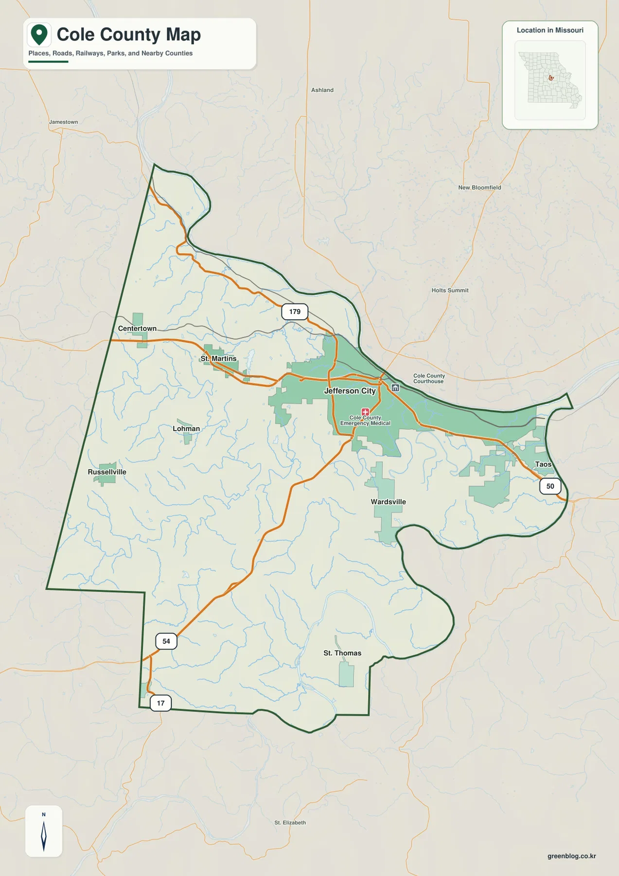
This overview is best used for county-scale orientation rather than turn-by-turn navigation. It shows where communities, major highways, streams, parks, and the county boundary sit in relation to one another. For a classroom handout or printed reference, a clear approach is to mark Jefferson City first, then trace U.S. 50 east, U.S. 179 northwest, and U.S. 54 southwest. The smaller places and waterways become much easier to place once that basic road framework is established.
Six major communities and the strong pull of Jefferson City
The ranked city distribution map highlights six places: Jefferson City first, Wardsville second, Taos third, St. Martins fourth, Russellville fifth, and Centertown sixth. Their locations matter more than the ranking numbers themselves. Jefferson City occupies the northeast-central area, Wardsville sits to the south, Taos is farther east, St. Martins lies west of the city, and Russellville and Centertown spread across the western side. The county’s settlement pattern therefore extends in several directions instead of forming one continuous urban strip.
The index printed on the map lists Jefferson City at 42,488, Wardsville at 1,579, Taos at 1,242, St. Martins at 1,228, Russellville at 833, and Centertown at 297. The wide gap between Jefferson City and the other entries makes the county’s main center unmistakable. Even so, a map of Cole County would be incomplete if the smaller western and southern communities were ignored. They provide reference points for the road network and help show how quickly the landscape changes beyond the Jefferson City area.
Wardsville lies near the winding Moreau River corridor south of Jefferson City. Taos is positioned on the eastern side close to U.S. 50, while St. Martins belongs to the road corridor west of the city. Russellville and Centertown are farther from the main urban area and are separated by rolling ground, creeks, and local roads. St. Thomas does not appear in the six-place ranking but is visible on the general map, which is a useful reminder that the ranked city image is a summary rather than a complete place-name map.
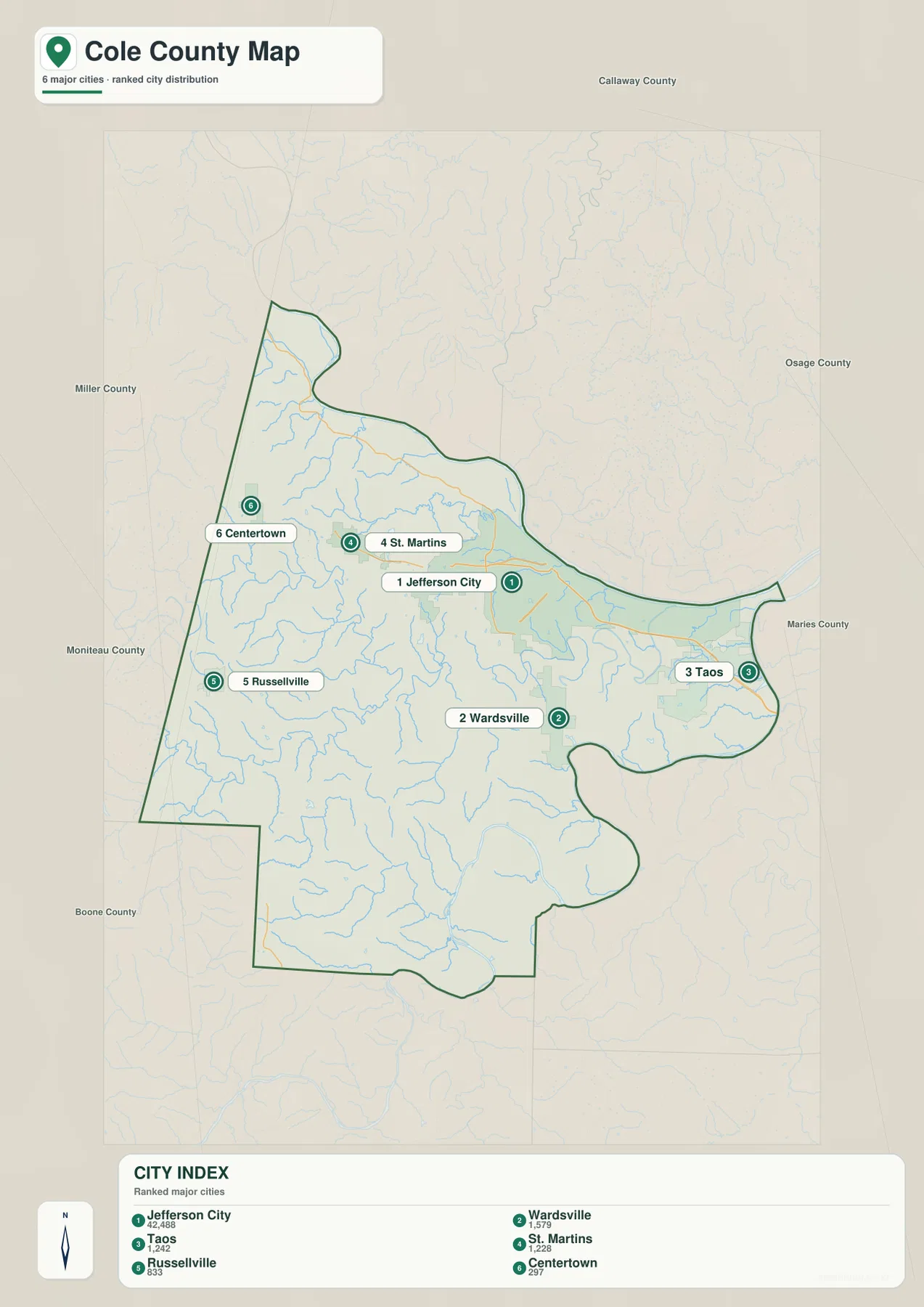
The ranking should not be read as a distance chart. The numbers do not indicate which cities are closest to one another, and the image does not provide driving mileage or travel time. It is most useful when the goal is to explain where the county’s major communities are located. For route planning, return to the general map and match the city positions to U.S. 50, U.S. 54, U.S. 179, and the connecting local roads.
Missouri River, Moreau River, and the creeks between them
The Missouri River dominates the northern edge of the terrain-and-water map. It follows a broad curve above Jefferson City and continues along the county boundary. South of the main channel, short tributaries such as Rock Creek, Meddows Creek, and Grays Creek cut through the hills. Binder Lake and Lake Claradean are also labeled in this northern part of the county, adding smaller bodies of water among the creek valleys west of Jefferson City.
The Moreau River is the major interior waterway. It winds across the central and eastern side in a lower corridor, receiving numerous small tributaries as it moves through the county. McKay Lake and Renns Lake appear near this drainage, while additional Moreau Creek branches extend westward. The irregular southeastern county outline is easier to understand here because the river valley is shown together with shaded relief rather than as a simple blue line on a road map.
Farther south, S Moreau Creek and Bois Brule Creek occupy separate valleys before the land drops toward the Osage River, which is labeled just below the county’s southern edge. This arrangement gives Cole County a layered river setting: the Missouri River along the north, the Moreau River through the interior, and the Osage River near the south. Between them, many smaller creeks divide the uplands into ridges and narrow valleys instead of leaving one broad, level surface.
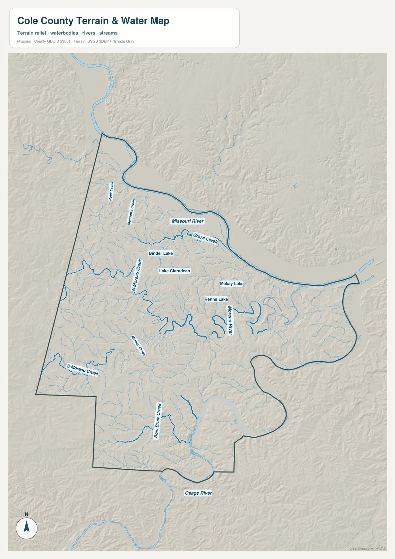
The water layer is a geographic reference, not a live flood or stream-condition product. A low valley beside the Missouri or Moreau River may be obvious on the shaded relief, but this image does not establish current flood stage, flood-insurance zones, levee performance, or the safety of a particular property. Those decisions require current FEMA products, USGS stream information, and local guidance. Here, the value of the map is in showing where the named waterways and their valleys sit within the county.
A 160–312 meter landscape of river bottoms, ridges, and narrow valleys
The elevation image reports an actual range of about 160 to 312 meters and a mean of about 211 meters. Greens represent the lower parts of the county, while tan and brown tones mark higher ground. The broadest low areas follow the Missouri River along the north and the Moreau River through the central and eastern side. Higher terrain is more extensive in the west and southwest, where narrow green valleys cut repeatedly into tan ridges.
The area around Centertown and Russellville shows especially frequent relief changes. Ridges extend between small drainage channels, so the western side appears more textured than the river margins. The U.S. 54 corridor also crosses a landscape that rises and falls as it heads southwest. Around St. Thomas, the southern terrain remains broken before descending toward the Osage River. Jefferson City itself is close to a sharp contrast between the low Missouri River corridor and higher ground immediately to the south.
The Moreau River can be followed on the elevation image as a broad green ribbon with tight bends. Smaller tributaries branch from it as thinner low strips, matching many of the blue lines on the water map. This comparison is useful because it shows why the river follows the route it does: the channel occupies a lower valley between surrounding ridges. The same relationship appears around the northern tributaries of the Missouri River and the southern creeks that descend toward the Osage.
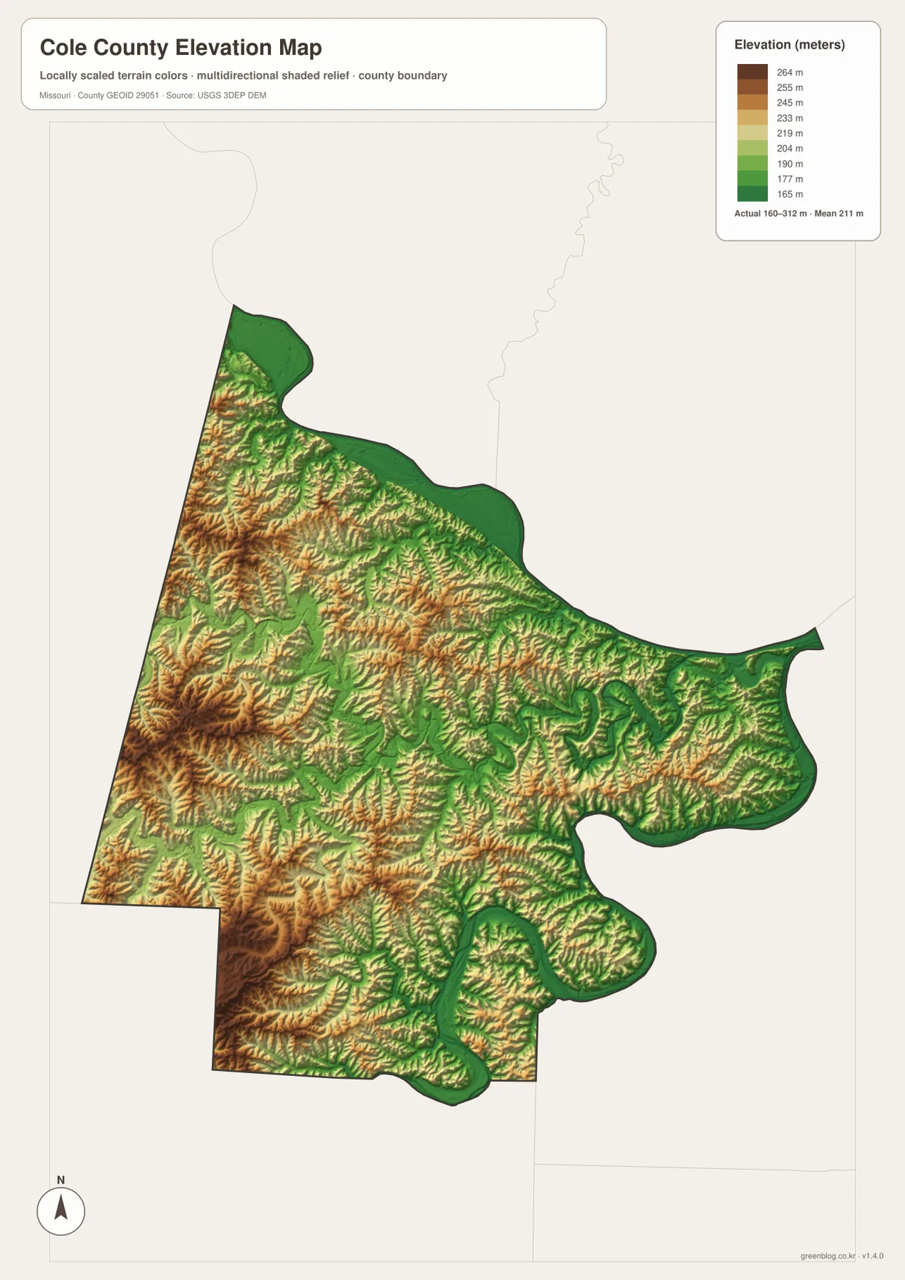
Elevation colors should not be mistaken for land cover or land-use categories. Green does not automatically mean wetland or cropland, and brown does not indicate forest, protected land, or a development restriction. The image is scaled to make relative elevation within Cole County easy to compare. Engineering, drainage design, construction, or surveying work should rely on source elevation data such as the USGS 3D Elevation Program and, where needed, professional field measurements.
Choosing the most useful Cole County file for your purpose
For basic orientation, start with the general county map. Jefferson City, U.S. 50, U.S. 54, and U.S. 179 establish the main directions, and the smaller communities can then be added around that frame. The ranked city map removes much of the road detail and works better when a presentation or lesson needs a clean view of the six major communities. It is particularly effective for comparing Jefferson City with Wardsville, Taos, St. Martins, Russellville, and Centertown without the distraction of every local road.
Use the terrain-and-water map when rivers, tributaries, and valleys are the main subject. The Missouri River provides the northern boundary, the Moreau River crosses the interior, and the Osage River appears near the south. Binder Lake, Lake Claradean, McKay Lake, Renns Lake, and named creeks add local detail. The elevation map is better for a direct comparison of high and low ground, especially the contrast between the low river corridors and the more dissected western and southwestern ridges.
The downloadable JPG originals are 3638 by 2572 pixels each, giving more room to inspect labels, highway shields, smaller waterways, and shaded relief than the WebP previews embedded in the article. They are suitable for printing, classroom use, presentations, and personal reference. They are not substitutes for legal boundary records, parcel ownership maps, live navigation, flood-insurance determinations, or engineering surveys.
A practical way to compare the files is to keep Jefferson City as the common reference point. First use the general map to establish the main highways and surrounding communities. Next check the ranked city map to simplify the settlement pattern. Then trace the Missouri and Moreau rivers on the terrain-and-water map, and finish by locating the same valleys on the elevation image. Moving through the county in that order keeps roads, towns, streams, and relief connected to the same real places.
Frequently Asked Questions
Which highways are the best starting points for locating places around Jefferson City?
Start with U.S. 50, U.S. 54, and U.S. 179. U.S. 50 points toward Taos on the east side, U.S. 179 reaches toward St. Martins and Centertown to the northwest, and U.S. 54 continues southwest through the county. Together they provide a simple road framework for locating most of the other labeled places.
How can I tell the Missouri River from the Moreau River on the maps?
The Missouri River is the much larger channel that follows the county’s northern boundary. The Moreau River lies farther south and winds through the central and eastern interior with many tight bends. On the elevation map, both waterways occupy lower green corridors, but the Missouri forms the broad northern edge while the Moreau cuts through the county itself.
Does the green color on the elevation map show flood-prone land?
No. Green indicates lower elevation within Cole County, not an official flood zone or wetland category. River valleys naturally appear lower, but flood risk for a property must be checked with current FEMA mapping, USGS hydrologic information, and local sources rather than inferred from elevation color alone.
Map File Information
The ZIP contains the high-resolution JPG originals for the general county map, ranked city map, terrain-and-water map, and elevation map shown on this page.
- Included Files: 4 maps
- File Type: JPG
Related Maps
Sources and references
- U.S. Census Bureau TIGER/Line Shapefiles – official geographic boundary and road data resources.
- USGS National Hydrography – official hydrography resources for rivers, streams, and water bodies.
- USGS 3D Elevation Program – official elevation data and terrain resources from the U.S. Geological Survey.
Green Map creates custom-edited map images using open geographic data sources such as geoBoundaries, Natural Earth, OpenStreetMap, and government open data. These maps are edited visual materials, not raw data files, and are provided for education, documents, presentations, and graphic reference.