Christian County sits in southwestern Missouri, where the northern communities of Nixa and Ozark give way to a more deeply cut Ozark landscape toward the south and east. The general map places Nixa, Ozark, Clever, Sparta, Highlandville, Billings, and several smaller communities beside major routes such as U.S. 65, U.S. 160, and Route 14. The high-resolution JPG versions used for this page can be downloaded together in the ZIP box below, which is useful when the on-page WebP images are too small for road numbers, stream names, or terrain detail. High-resolution map files are available for download in the section below.
Nixa and Ozark are the easiest places to use as anchors. They sit close to the northern center of the county, with Route 14 running east-west through the area and U.S. 65 passing near Ozark on a north-south line. Clever and Billings lie to the west, Sparta is farther east, and Highlandville and Spokane sit well to the south. That arrangement makes Christian County more interesting than a simple city-centered map: the northern built-up area, the rural road network, and the broken hills of the south each occupy a distinct part of the county.
The official Christian County website lists Billings, Clever, Fremont Hills, Highlandville, Nixa, Ozark, Sparta, and the Village of Saddlebrooke among the county’s cities. Several of those places appear on the general map, while the ranked city map highlights six of them. Rather than treating every image as a separate inventory, this guide uses those named communities, the visible highway network, the mapped streams, and the local elevation range to explain how the county fits together.
Table of Contents
Nixa, Ozark, and the road pattern across northern Christian County
On the general county map, Nixa lies west of Ozark near the northern center of Christian County. Route 14 crosses this part of the county from west to east and continues toward Sparta, making it the clearest route for comparing the northern communities. U.S. 65 passes near Ozark and runs south through the county, while roads west of Nixa lead toward Clever and the narrow western extension around Billings. Finding those major lines first makes the many smaller roads and stream crossings much easier to place.
The mapped developed areas are most extensive around Nixa and Ozark, with Fremont Hills close by to the north. Sparta forms a separate eastern center, while Highlandville and Spokane are farther south where the road network spreads across more rugged terrain. The contrast is visible even without a population table: the north contains a cluster of larger built-up areas, but the south and east have more space between settlements and a denser background of branching stream valleys.
Billings is especially useful for understanding the county outline. The boundary reaches west in a narrow projection, and the map shows U.S. 60 along with Route 413 and Route 173 near that side. Clever sits between the Billings area and Nixa. Because the county outline steps inward and outward rather than forming a simple rectangle, a place that looks close to Christian County on a regional map may actually lie across a county line. The general map keeps that boundary visible while still showing nearby reference places.
Sparta and the Route 125 side of eastern Christian County look quite different from the Nixa-Ozark corridor. Built-up polygons are smaller, local roads are more widely spaced, and blue stream lines appear in many small branches. Labels outside the county include places such as Republic, Battlefield, Rogersville, and Fordland, which help establish regional direction. The map is a geographic reference rather than a live navigation product, so current closures, construction, and travel times should always be checked with up-to-date road information.
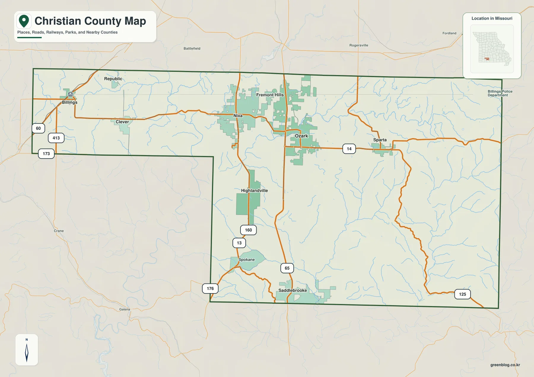
This general map is the best starting point for a first look at Christian County because it keeps cities, roads, streams, and the county boundary on the same page. Once Nixa and Ozark are located, the water and elevation maps become easier to interpret. The James River and Finley Creek can then be matched to the same northern area, while the more dissected southern terrain can be related back to roads around Highlandville, Spokane, Saddlebrooke, and Route 125.
What the ranked city map says about the county’s settlement pattern
The city map removes most road detail and marks six major communities with rank numbers. Its index places Nixa first, Ozark second, Clever third, Sparta fourth, Fremont Hills fifth, and Highlandville sixth. Population figures are printed beside those names on the map, but the more useful feature for this page is their geographic arrangement. The ranks and positions show that Christian County’s largest mapped communities are not evenly scattered across the county.
Nixa and Ozark sit near one another in the north, and Fremont Hills is also close to that same cluster. Clever extends the northern pattern westward, while Sparta stands apart to the east. Highlandville is the southernmost of the six ranked cities, creating a clear visual gap between the northern group and the more sparsely settled southern half of the county. That simple distribution is easier to see here than on the general map because most minor labels have been removed.
This is not a distance-connection map. The rank numbers do not represent miles, driving time, or the size of municipal boundaries, and two markers that look close on the page may still be separated by winding roads and stream valleys. The image works well when the question is “Where are the principal communities?” rather than “How long will a trip take?” For travel planning, return to the road map and then check a current navigation source.
The official county website also lists Billings and the Village of Saddlebrooke, both of which are visible on the general map but are not among the six highlighted city-index entries. That difference is a reminder that a thematic map is selective by design. A clean rank map can make the main settlement pattern obvious, while the more detailed county map is better for checking smaller communities, road connections, and the full shape of Christian County.
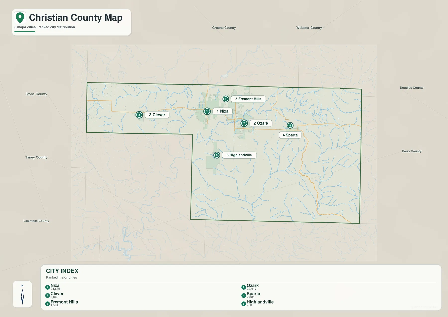
Comparing this map with the elevation image adds useful context. The northern communities occupy broad upland areas separated by stream valleys, whereas the southeastern part of Christian County is cut by many more narrow drainage lines. Sparta lies closer to that more dissected eastern terrain, and Highlandville sits where the southern hill country becomes increasingly evident. The combination helps explain why settlement density and road spacing differ from one part of the county to another without turning the page into a technical land-use analysis.
James River, Finley Creek, and the branching streams of the southern hills
The terrain-and-water map gives the James River the strongest visual presence in northwestern Christian County. It enters a broad valley, bends through the western and north-central area, and is joined by smaller drainage lines. Terrell Creek is labeled near the northern side, and Green Valley Creek appears near the James River corridor. The shaded relief makes the river valley stand out as a low passage between higher ground rather than just a blue line drawn across a flat background.
Finley Creek is the other major northern reference. It extends across the north-central and northeastern part of the county, with many short tributaries feeding it from both sides. Lindenlure Lake is labeled along this system, and Murphy Pond appears farther east. When the water map is compared with the Nixa-Ozark road map, the dense network of small valleys around the northern communities becomes much easier to understand. Roads are crossing a landscape divided by creeks rather than a single broad plain.
South of the northern city belt, the drainage pattern becomes even more intricate. Horn Creek and Woods Fork appear in the central-southern area, while Bull Creek and East Fork Bull Creek create long low corridors farther east. Barnes Creek, Swan Creek, and Cedar Creek continue the pattern into the southeastern part of Christian County. Numerous unnamed tributaries branch from those streams, producing the tightly folded look that is especially clear in the shaded terrain background.
Willow Pond, Lindenlure Lake, and Murphy Pond are also labeled. They are small compared with the main river and creek systems, but they help show that the county’s mapped water features include more than flowing streams. For a classroom map, those names can be useful examples of how ponds, lakes, tributaries, and larger rivers occupy different positions within the same drainage landscape. The point is not to memorize every label but to see how water repeatedly follows the lower valleys.
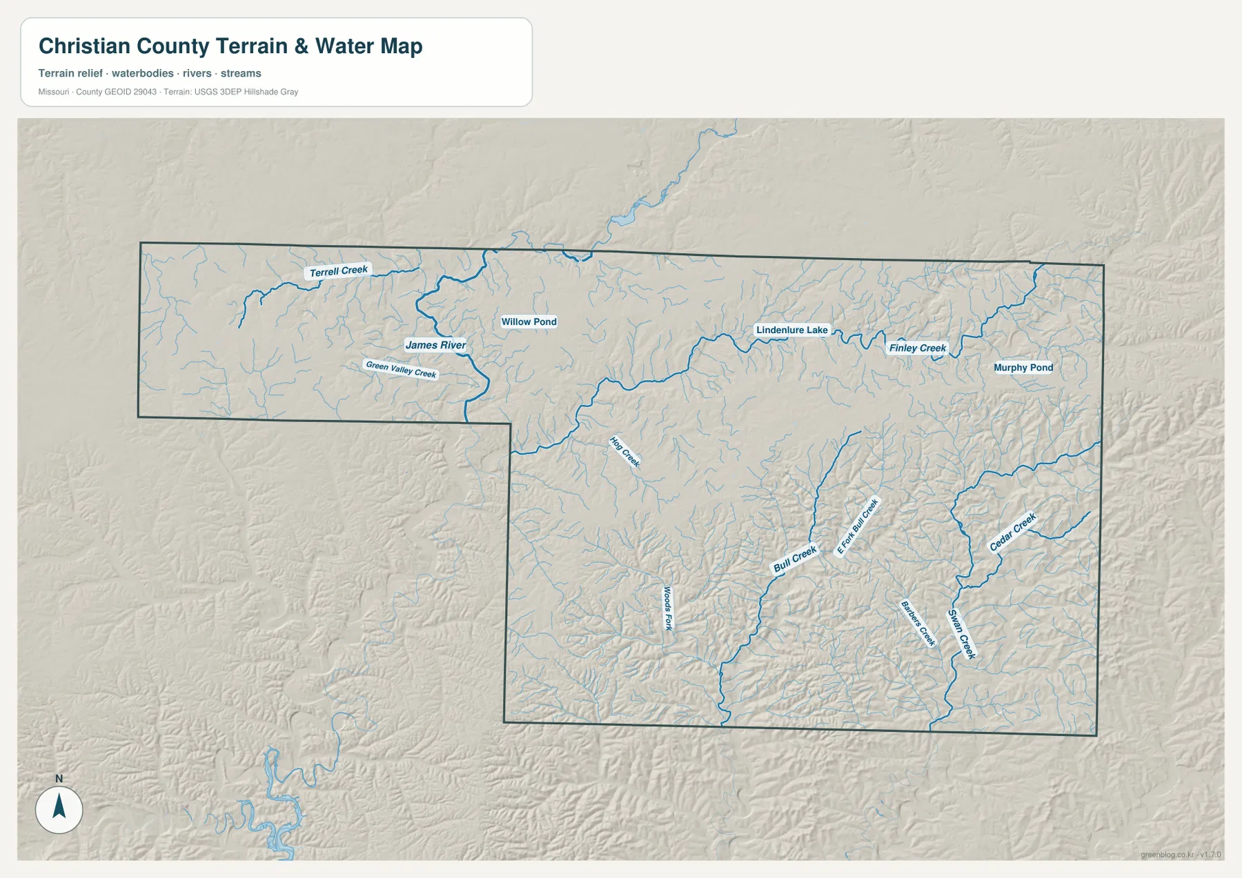
This image should not be read as a live flood, boating, or access map. A blue stream line identifies mapped hydrography, not current depth, legal access, flood stage, or safe crossing conditions. For property decisions, flood safety, or real-time river conditions, use current USGS information, official flood products, and local guidance. The strength of this map is its regional view: it shows where water occupies the low parts of the Christian County terrain and how those valleys connect.
From 256 to 485 meters: relief across the Ozark uplands and stream valleys
The elevation map reports an actual Christian County range of about 256 to 485 meters, with a mean near 381 meters. That span of more than 200 meters produces a strong pattern of ridges and valleys rather than a smooth slope from one side of the county to the other. Greens indicate lower terrain within the local color scale, while yellows, oranges, and browns mark progressively higher ground. The highest-looking areas are concentrated toward the east and northeast, with additional uplands around the county margins.
The James River and Finley Creek corridors appear as long green bands because the stream valleys lie below nearby uplands. Around Nixa and Ozark, those low corridors alternate with broad ridges, so the northern developed area is not perfectly flat even though it looks less rugged than the southeast. Matching the green valley shapes with the water map makes it easy to identify which low areas correspond to named rivers and creeks.
Eastern and southeastern Christian County show a finer texture. Narrow green valleys branch repeatedly between orange and brown ridges, especially around the Route 125 side and the Cedar Creek-Swan Creek area. Similar incised terrain follows Bull Creek and Woods Fork farther west. The result is a landscape where short straight-line distances can cross several rises and drops, one reason local roads often curve with the terrain rather than following a simple grid.
The color scale is local to this county map. Green does not mean wetland or official floodplain, and brown does not mean a protected mountain area or a development restriction. The map is designed to make relative height differences visible. Surveying, construction, drainage design, and other work that requires exact elevations should use USGS 3D Elevation Program data or professional measurements rather than values estimated from this image.
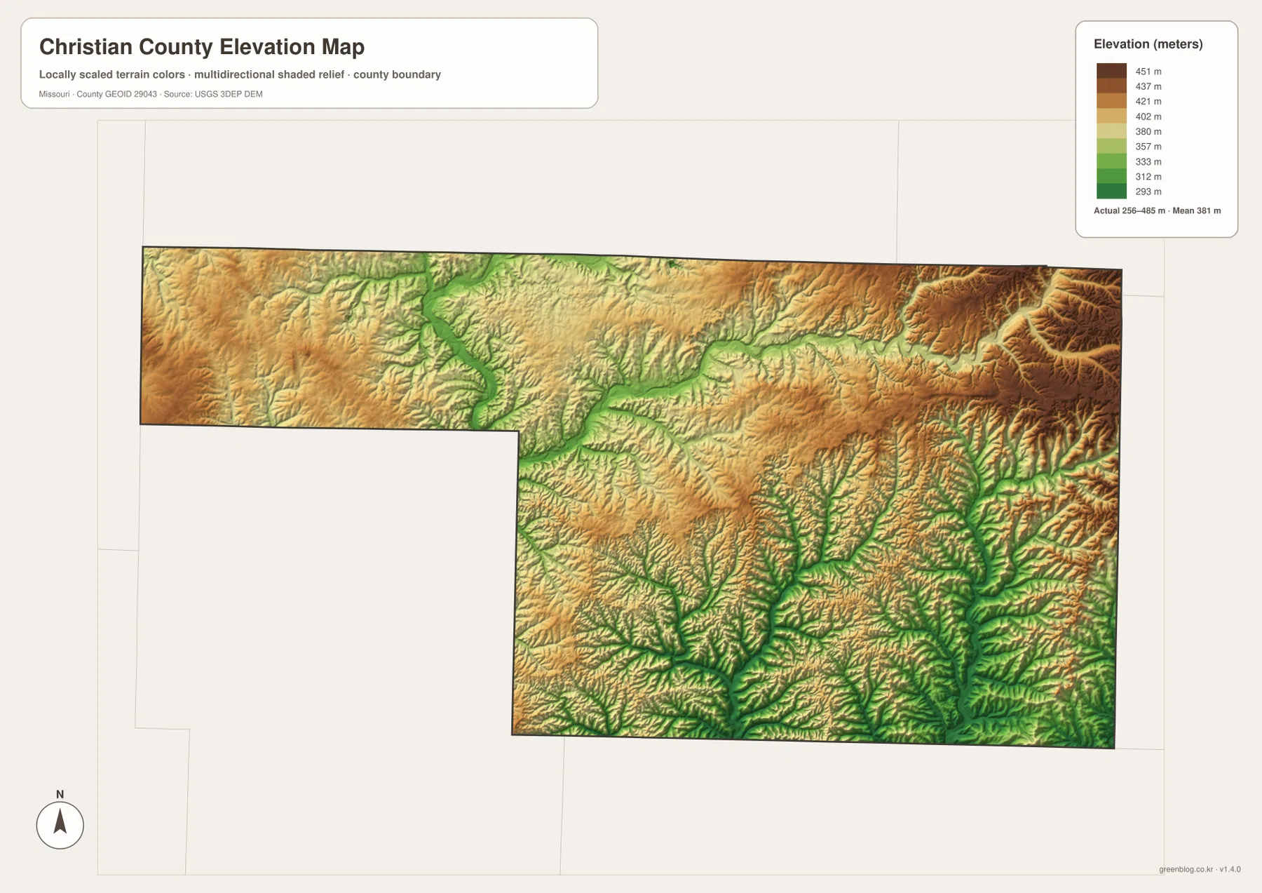
Reading the road and elevation maps together gives the city pattern more physical context. Nixa and Ozark occupy relatively broad upland surfaces broken by nearby valleys, while the terrain south and east of Sparta becomes more sharply dissected. Highlandville and Spokane appear as simple points on the road map, but the elevation layer shows that they sit within a southern landscape of closely spaced ridges and drainage cuts. That comparison is often more informative than looking at the color scale by itself.
Choosing the most useful Christian County map for the task
Start with the general county map when the goal is orientation. It combines Nixa, Ozark, Clever, Sparta, Highlandville, Billings, major numbered roads, nearby reference places, the county outline, and a background of streams. U.S. 65 and Route 14 provide easy anchors, after which smaller roads and communities can be placed relative to the northern urban cluster and the southern hill country.
Choose the ranked city map when a cleaner explanation of settlement is more important than road detail. It quickly shows the concentration of Nixa, Ozark, and Fremont Hills in the north, Clever to the west, Sparta to the east, and Highlandville to the south. Because it highlights only six cities, it should be paired with the general map or the official county list when a complete set of municipal names is required.
Use the terrain-and-water map for river and creek questions. The James River and Finley Creek provide strong northern references, while Bull Creek, East Fork Bull Creek, Swan Creek, Cedar Creek, and other tributaries explain the more dissected southern terrain. The elevation map is better when the main question is height: it turns the same valleys and ridges into a clear high-low color pattern and makes the 256-to-485-meter range easy to compare.
The download archive contains the original high-resolution JPG versions of all four maps shown on this page. Each file is 3638 by 2572 pixels, giving more room to enlarge place labels, route shields, stream names, and shaded relief than the embedded WebP previews. They work well for general reference, classroom material, print layouts, and presentations, but they do not replace legal boundary surveys, property records, flood-insurance maps, current navigation, or engineering-grade elevation data.
A practical reading order is to locate Nixa and Ozark first, follow Route 14 and U.S. 65 to establish direction, then switch to the water map to find the James River and Finley Creek. Finish with the elevation map and compare the greener stream valleys with the higher eastern and northeastern ridges. Following that sequence turns four separate images into one coherent picture of Christian County: a more urban north surrounded by a road network that extends into increasingly rugged Ozark terrain.
Frequently Asked Questions
What is the easiest way to tell Nixa and Ozark apart on the map?
Use Route 14 and U.S. 65 as anchors. Nixa is west of Ozark along the northern part of Christian County, while U.S. 65 passes near Ozark on a north-south course. Once those two cities are located, Clever is easier to place to the west, Sparta to the east, and Highlandville farther south.
Are Billings and Saddlebrooke outside Christian County because they are not on the ranked city map?
No. The official Christian County website lists Billings and the Village of Saddlebrooke among the county’s cities, and both appear on the more detailed general map. The ranked city image intentionally highlights only six major communities, so it should not be treated as a complete municipal inventory.
Does green on the elevation map identify flood-prone land?
No. Green represents relatively lower elevation within the local Christian County color scale, which is why stream valleys such as the James River, Finley Creek, and Bull Creek stand out. Actual flood risk depends on rainfall, stream stage, drainage, mapped floodplains, and other conditions. Use current FEMA, USGS, and local information for property or safety decisions.
Map File Information
The ZIP contains the original high-resolution JPG files for the general county map, ranked city map, terrain-and-water map, and elevation map shown in this article. The originals are larger than the on-page WebP images and make city labels, road numbers, stream names, and terrain detail easier to inspect.
- Included Files: 4 maps
- File Type: JPG
Related Maps
Sources and References
- Christian County Missouri official website: official county information and a list of cities in Christian County.
- U.S. Census Bureau QuickFacts – Christian County, Missouri: official county statistics and geographic information.
- U.S. Census Bureau TIGER/Line Shapefiles: official county-boundary and transportation geography.
- USGS National Hydrography: official river, stream, lake, and related hydrography data.
- USGS 3D Elevation Program: official elevation and terrain-surface data.
Green Map creates custom-edited map images using open geographic data sources such as geoBoundaries, Natural Earth, OpenStreetMap, and government open data. These maps are edited visual materials, not raw data files, and are provided for education, documents, presentations, and graphic reference.