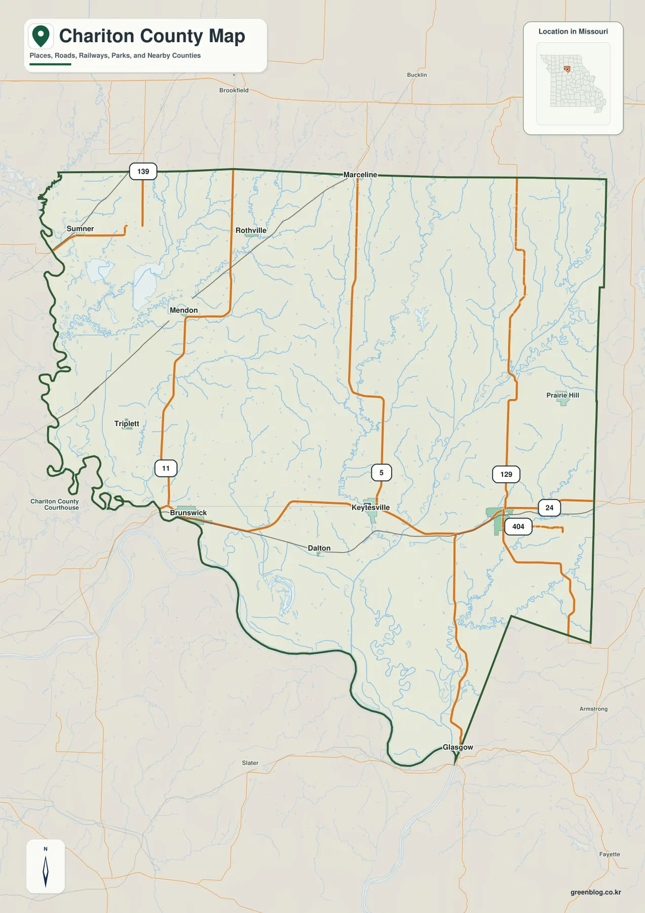
Chariton County lies in north-central Missouri, with a road pattern that looks simple until the rivers and relief are added. Keytesville sits in the southern interior near U.S. 24 and Route 5, Salisbury is farther east near U.S. 24 and Route 129, and Brunswick stands near the Missouri River on the southwest side. High-resolution JPG originals of the county map, ranked city map, terrain-and-water map, and elevation map can be downloaded together from the ZIP box below. High-resolution map files are available for download in the section below.
The official county website identifies Keytesville as the county seat and records that Chariton County was organized in 1820 and named for the Chariton River. Those names are not just historical details on this page. The Chariton River runs through the southern part of the county toward the Missouri River, Brunswick sits close to the broad river bottoms, and Keytesville occupies the road-and-river country between Brunswick and Salisbury.
The county outline also changes noticeably around its perimeter. The Missouri River creates a deeply curved western and southern edge, while much of the north and east is comparatively straight. Inside that boundary, Routes 11, 5, and 129 run generally north and south, and U.S. 24 crosses the southern half from the Salisbury side toward Keytesville and Brunswick. Smaller creeks cut between those roads, so the water and elevation maps reveal far more variation than the road network alone suggests.
Table of Contents
U.S. 24 and Keytesville organize the southern road pattern
U.S. 24 is the clearest east-west reference on the county map. It enters from the Salisbury side, passes the Keytesville area, and continues toward Brunswick near the Missouri River. That route links the three most prominent southern communities without implying that the rest of the county follows one corridor. Northbound roads branch away from it and reach smaller towns that are widely separated across the interior.
Route 5 runs north from the Keytesville area, Route 129 rises from the Salisbury side, and Route 11 reaches north from Brunswick toward Mendon. Rothville lies farther north near the central part of the county, while Sumner sits close to the western boundary. Route 139 crosses the northern portion. Reading these roads together makes it easier to see why the southern towns feel connected on the map even though the county’s settlement pattern extends well beyond U.S. 24.
The river boundary is equally important. Around Brunswick and farther south, the county edge follows large Missouri River bends rather than a straight survey line. The road map therefore shows a contrast between a highly irregular river side and the straighter north and east edges. It is a general county reference, not a parcel or legal-boundary document; an exact property or jurisdictional question should be checked against current official records.
Six ranked communities stretch from Salisbury to the western river edge
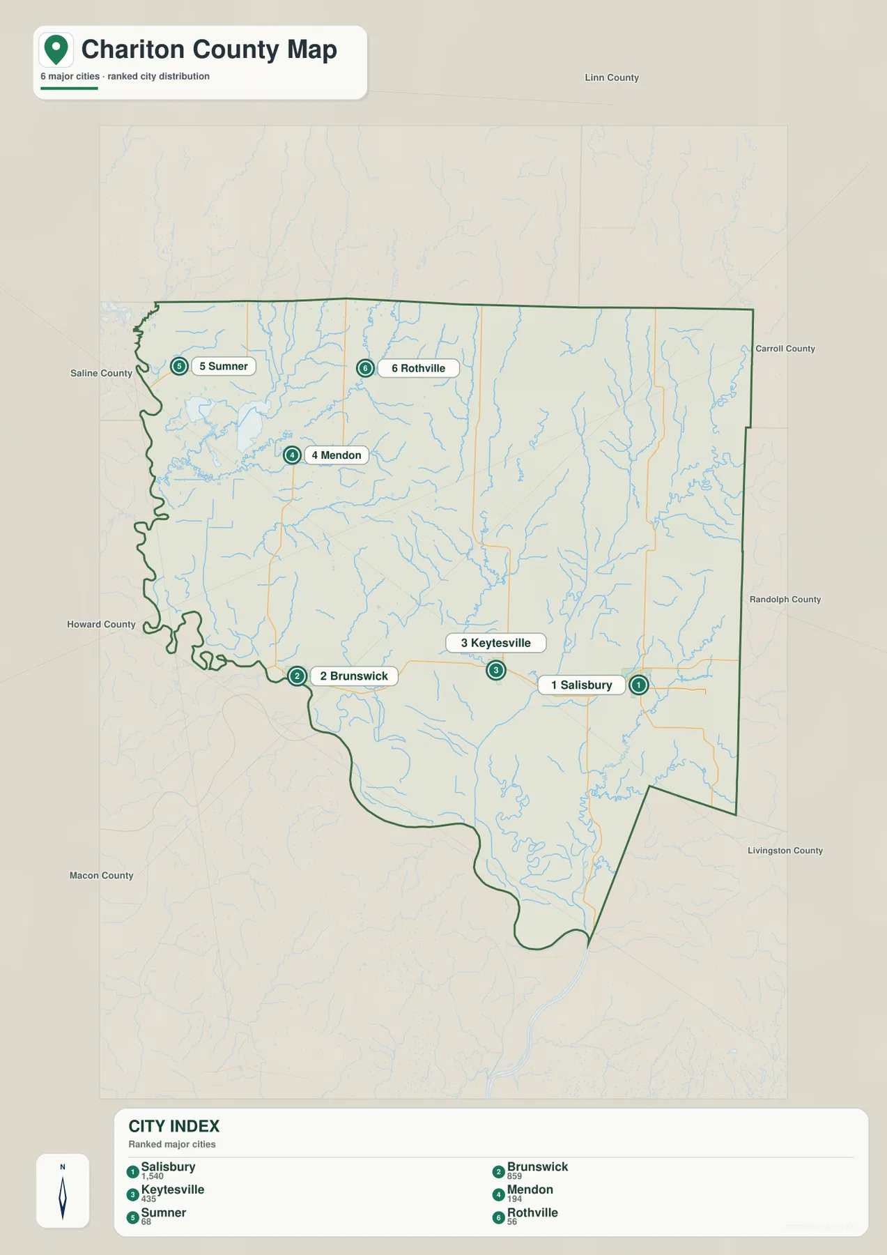
The ranked city map strips away most road detail and places six communities in a simple geographic frame. Salisbury is marked first, Brunswick second, Keytesville third, Mendon fourth, Sumner fifth, and Rothville sixth. The ranking is only one part of the picture: their locations show that the county does not have a compact urban cluster. Three of the ranked places occupy the southern half, while the other three are separated across the north and west.
Salisbury sits toward the southeast side of the county, Brunswick is near the southwest river boundary, and Keytesville is between them in the southern interior. Mendon lies north of Brunswick, Rothville is farther northeast, and Sumner is tucked close to the western edge. That spacing matters when comparing the county’s road network with its communities; a place that looks close on a simplified ranking map may still require a route that bends around creeks, river bottoms, or the available road grid.
This particular city graphic does not draw connector lines or label straight-line distances. Its purpose is the ranked distribution itself. For road travel, the county map carries the relevant highway labels; for settlement geography, the cleaner city view makes the southern group and the more isolated northern places easier to distinguish without a dense background of minor roads.
Missouri River bends frame the Chariton River and its smaller tributaries
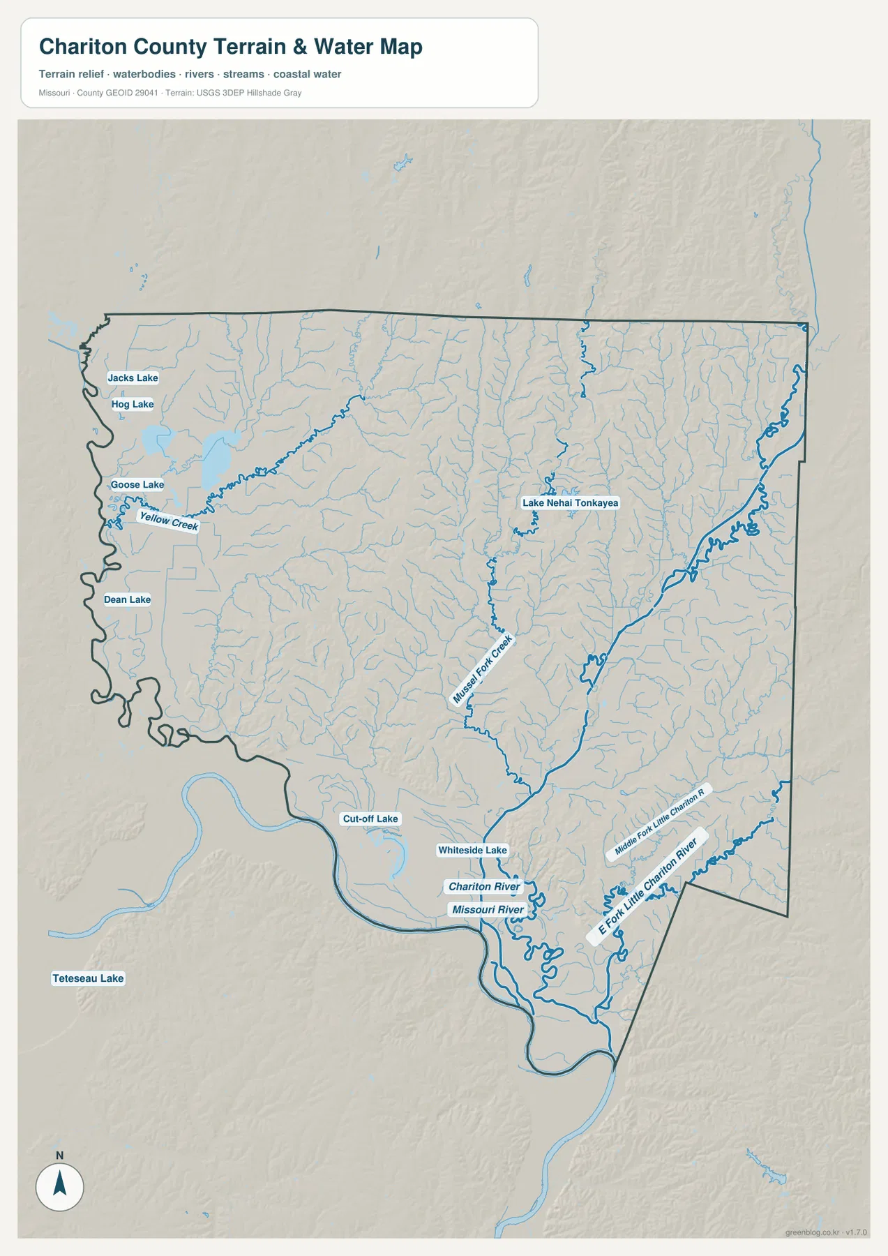
The terrain-and-water map shifts attention away from highways and toward the low corridors that cut through the county. The Missouri River follows the west and south side in broad bends. The Chariton River reaches the southern interior and continues toward that larger river, creating a broad low area near their meeting zone. Cut-off Lake and Whiteside Lake appear nearby, adding detail to a landscape shaped by river channels and former bends.
Farther inland, Mussel Fork Creek runs through the central part of the county, while Yellow Creek crosses the northwest. On the eastern side, the Fork Little Chariton River and Middle Fork Little Chariton River trace long valleys toward the south. These named tributaries explain why the interior relief is broken into many narrow ridges rather than forming one smooth upland surface.
Several smaller water bodies are labeled as well. Jacks Lake and Hog Lake sit in the northwest, Goose Lake lies nearby, and Dean Lake appears farther south along the western side. Lake Nehai Tonkayea is shown in the central-east area. The water map is meant to place these rivers, creeks, and lakes in their terrain setting; it does not establish flood zones, navigable channels, water depth, water quality, or property boundaries.
Elevation rises from the river bottoms into the central and northern ridges
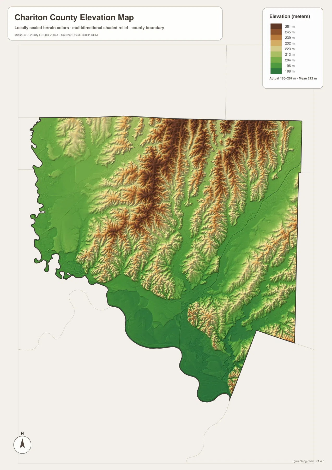
The elevation map gives an actual county range of about 185 to 267 meters, with a mean near 212 meters. The lowest green tones spread widely along the Missouri River and across the southern river bottoms. Low corridors also extend inland along the Chariton River and the Little Chariton drainage, matching the valleys emphasized on the water map.
Higher yellow and brown tones become much more common through the central and northern interior. Long narrow ridges alternate with creek valleys, especially across the north-central and northeast portions of the county. The western Missouri River side is much broader and flatter by comparison. This contrast explains why a county that has no dramatic mountain range can still show strong local relief on a shaded-elevation image.
The colors are a generalized representation of elevation across the county, not survey measurements for individual points. They work well for comparing river bottoms with uplands, but a construction, engineering, or legal elevation question requires current authoritative data. For general geographic reading, the map makes one relationship especially clear: the largest waterways occupy the lowest ground, while the narrow interstream ridges stand above them.
Match the map to the question you are asking about Chariton County
A road-and-place question begins with the county map: U.S. 24, Routes 5, 11, and 129, and the positions of Salisbury, Keytesville, Brunswick, Mendon, Sumner, and Rothville are all visible together. When the main question is simply how the six ranked communities are distributed, the city graphic removes much of that detail and makes the south-versus-north spacing easier to see.
River geography calls for a different view. The terrain-and-water map names the Missouri River, Chariton River, Mussel Fork Creek, Yellow Creek, the Little Chariton forks, and several lakes. The elevation image then adds the height contrast, showing the wide southern bottoms below the narrower interior ridges. Looking at those two together connects stream location with the shape of the land without turning the page into a technical GIS report.
The ZIP download contains the same four subjects as 3638×2572-pixel JPG originals. The larger files make small road numbers, place names, water labels, and relief shading easier to inspect than they are in a web preview. They fit classroom material, presentations, and general printed reference, but they should not replace legal boundary records, current traffic services, official flood determinations, navigation products, or engineering surveys.
Frequently Asked Questions
How are Keytesville, Salisbury, and Brunswick positioned within the county?
All three are in the southern half, but they are spread across it. Salisbury is on the eastern side near U.S. 24 and Route 129, Keytesville is in the southern interior near U.S. 24 and Route 5, and Brunswick is close to the Missouri River on the southwest side. Mendon, Rothville, and Sumner extend the settlement pattern farther north and west.
Why is the Missouri River side so low on the elevation map?
The Missouri River occupies a broad valley and bottomland that sits below the rolling interior ridges. Similar low corridors follow the Chariton River and other major tributaries. On the elevation image, those areas appear in green while many central and northern ridges shift into yellow and brown. Elevation alone, however, does not define an official flood zone.
What is included in the Chariton County download ZIP?
The archive contains four 3638×2572 JPG originals: a county boundary-and-road map, a ranked six-community map, a terrain-and-water map with the Missouri and Chariton rivers and their tributaries, and an elevation map covering an approximate 185–267 meter range.
Map File Information
The ZIP contains high-resolution JPG originals of the county map, ranked city map, terrain-and-water map, and elevation map shown on this page. The larger files make town names, road numbers, rivers, creeks, lakes, and shaded relief easier to inspect.
- Included Files: 4 maps
- File Type: JPG
Related Maps
Sources and references
- Chariton County, Missouri official website: county government information, county-seat context, and local history.
- Chariton County Historical Society: local history and museum resources.
- U.S. Census Bureau TIGER/Line Shapefiles: official geographic data for county boundaries, roads, and related features.
- USGS National Hydrography: official reference data for rivers, streams, and water bodies.
- USGS 3D Elevation Program: official elevation and terrain-surface data.
Green Map creates custom-edited map images using open geographic data sources such as geoBoundaries, Natural Earth, OpenStreetMap, and government open data. These maps are edited visual materials, not raw data files, and are provided for education, documents, presentations, and graphic reference.