Carroll County sits in northwestern Missouri where a practical road center around Carrollton meets a very different river landscape along the south and east. U.S. 65 runs north-south through the county, while Route 24 crosses the central area and continues east toward De Witt and the Brunswick side of the region. The maps on this page also show the distribution of Carrollton, Norborne, Hale, Bosworth, Tina, and Bogard; the Wakenda Creek and Big Creek drainages; and the broad lowlands associated with the Missouri and Grand rivers. The four original high-resolution JPG maps used here can be downloaded together in one ZIP archive from the download box below.
The county outline itself tells part of the story. Much of the north and west is comparatively simple, but the southern border follows large bends of the Missouri River and the eastern edge follows the Grand River before the two meet near the southeast. Those river-controlled boundaries contrast sharply with the dissected uplands in the northwest. Carroll County’s official overview likewise describes the county as lying on the Missouri River, with Grand River tributaries influencing the northern and eastern side.
Carrollton is the easiest place to use as a reference point. It is the county seat and lies close to the meeting of U.S. 65, Route 24, and the Route 10 corridor. Tina and Hale are farther north, Bosworth lies to the northeast, Norborne is southwest, and De Witt is east toward the river lowlands. Once those relationships are clear, the terrain and water maps become much easier to read because each creek and elevation band can be tied back to a familiar town or highway.
Table of Contents
Carrollton Anchors the U.S. 65 and Route 24 Road Pattern
On the general county map, Carrollton is the strongest visual anchor. U.S. 65 approaches from the north, passes the Carrollton area, and continues south toward the Missouri River side of the county. Route 24 runs east-west through the same central zone and continues toward De Witt and Brunswick. Route 10 enters from the southwest near Norborne and converges on the Carrollton area. Together these roads make the county center much easier to understand than a list of town names alone.
North of Carrollton, the highway pattern is relatively direct, but the surrounding landscape is cut by many smaller streams. Tina lies north of the county center and Hale is near the northern edge. Bosworth occupies the northeast and is associated with Route 139, which continues south toward the De Witt area. The northern communities therefore form a dispersed group rather than a single continuous corridor, with local roads bridging the gaps between U.S. 65, Route 139, and smaller routes.
The eastern side looks different because the county boundary begins to follow large river bends. De Witt is positioned near this lower, flatter setting, while Brunswick and Miami appear outside the county as useful reference points. The road map does not show every physical detail, but it makes clear that the eastern transportation pattern sits closer to the Grand and Missouri river lowlands than the western and northwestern towns do.
Carroll County’s official transportation summary identifies U.S. 65 as the principal north-south highway and U.S. 24 as a major east-west route. That relationship is easy to see in the map. Route 139 and Route 10 add regional connections, while the smaller roads reach rural areas between the towns. Because this is a static geographic reference, current closures, work zones, weight restrictions, and detours should still be checked with up-to-date transportation services before driving.
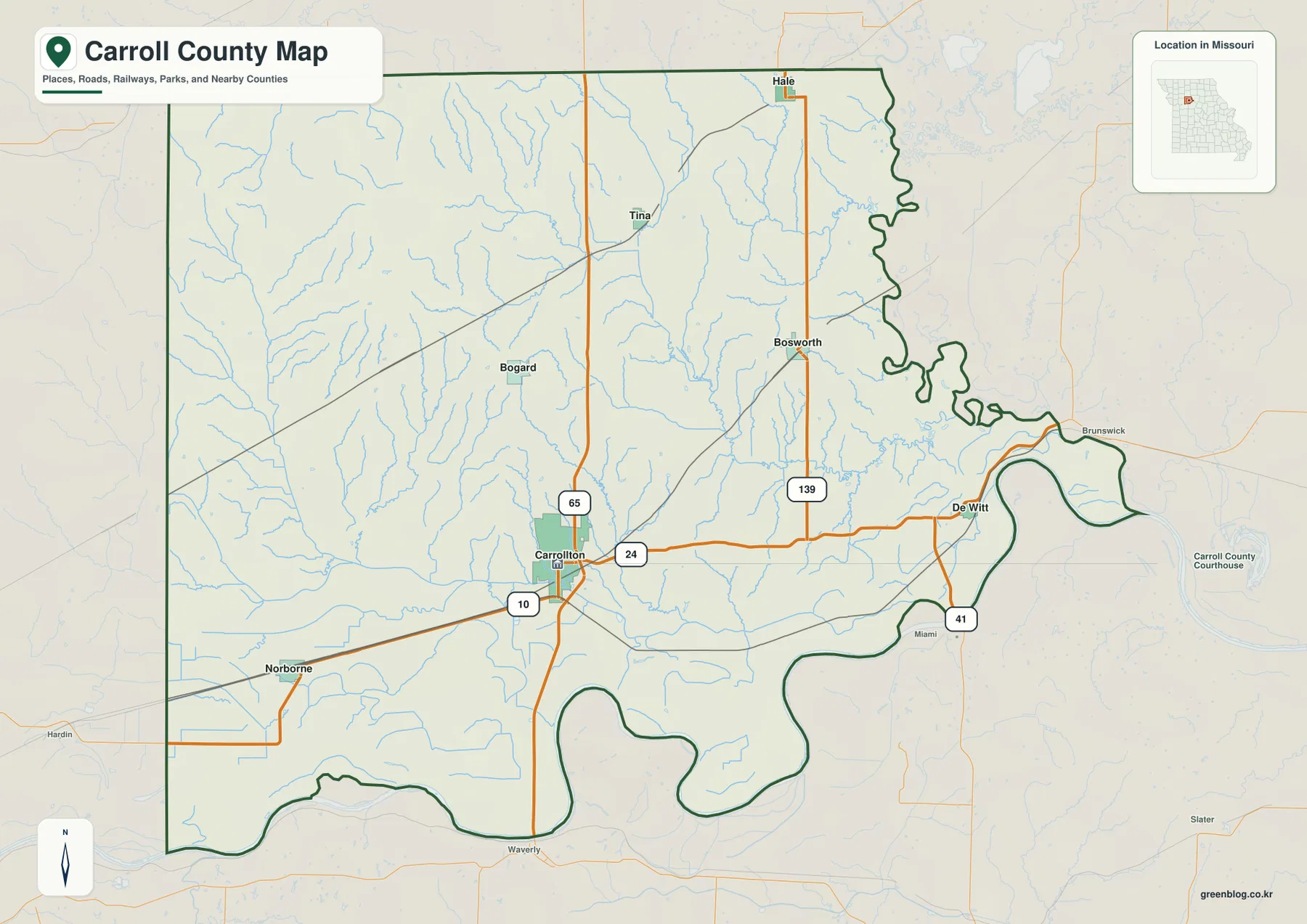
This general map is the best first choice when the goal is orientation. It combines communities, numbered routes, the county outline, nearby places, and smaller streams in one frame. After locating Carrollton, it is easy to identify Hale and Tina to the north, Bosworth to the northeast, Norborne to the southwest, and De Witt to the east. The water and elevation maps then add detail that the road-focused version deliberately keeps in the background.
Six Ranked Communities Spread from Norborne to Hale and Bosworth
The ranked city-distribution map simplifies the county by emphasizing six communities rather than the full road network. In the supplied index, Carrollton is ranked first, followed by Norborne, Hale, Bosworth, Tina, and Bogard. Numeric values are printed beside the names in the map legend, but they are best treated as the reference values built into this map rather than a permanent official population table. Census estimates can change, and municipal status should be checked against current government records when precision matters.
The spatial distribution is more useful than the ranking alone. Carrollton lies south of the county’s midpoint, Norborne is farther southwest, and Hale is near the north. Tina sits in the north-central area, Bogard is west of center, and Bosworth occupies the northeast. This spread shows why no single local road serves every community. The county’s road system depends on several north-south and east-west connections that meet near Carrollton but branch widely across the rural landscape.
Comparing this map with the road map clarifies the roles of individual towns. Carrollton combines county-government importance with a central highway position. Norborne is tied more strongly to the southwestern Route 10 approach, while Bosworth is associated with the Route 139 side of the county. Hale and Tina help define the northern rural area, and Bogard provides a reference point within the more dissected western uplands.
Carrollton is also significant in county history. The official county site identifies it as the county seat and explains that Carroll County was organized in 1833. The county was named for Charles Carroll of Carrollton, the last surviving signer of the Declaration of Independence at the time the naming decision was made. The same local history notes that Wakenda had been considered as the county name, which makes the surviving name of Wakenda Creek especially meaningful.
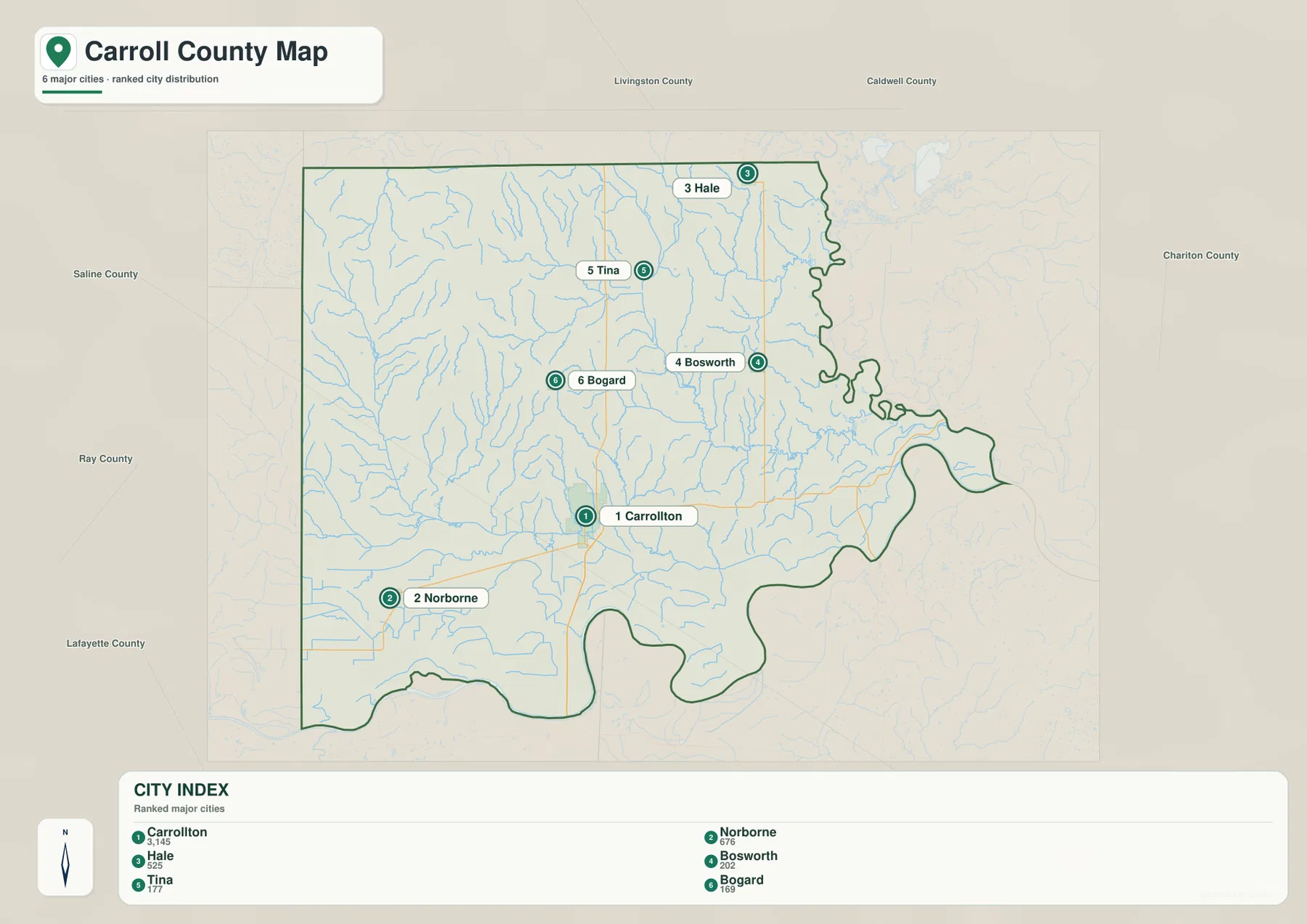
For a presentation, worksheet, or quick county overview, this simplified city map can be easier to read than the detailed road map. It removes many competing labels and makes directional relationships obvious. For trip planning or route comparison, however, return to the general map so that the city locations can be connected to U.S. 65, Route 24, Route 139, Route 10, and the surrounding local-road network.
Wakenda Creek and Big Creek Drain toward the Broad River Lowlands
Wakenda Creek is one of the strongest internal water features on the terrain-and-water map. It crosses the southern half of the county, passes the Carrollton area, and continues toward the Missouri River lowlands. The U.S. Geological Survey maintains a Wakenda Creek monitoring location at Carrollton, reinforcing the creek’s practical importance as well as its visual prominence on the map.
Little Wakenda Creek descends toward Wakenda Creek from the north, while Big Creek occupies a broad north-to-south corridor farther east. Shootman Creek and smaller branches add to the network between them. In the northeast, Hurricane Creek bends toward the Grand River side of the county. The shaded terrain makes these features easier to understand because many channels occupy visibly lower grooves between ridges rather than crossing a perfectly flat surface.
The western side includes Turkey Creek and McCroskie Creek, with several short tributaries cutting through the higher uplands. Near the southern lowland, the drainage pattern becomes broader and less tightly confined by ridges. Booker Slough and other lowland channels appear closer to the Missouri River floodplain. This transition from narrow upland valleys to broad bottomland drainage is one of the clearest physical differences visible across the county.
At the county scale, the Grand River and Missouri River form the dominant outer framework. The Grand River descends along the eastern boundary and meets the Missouri River near the southeast. Wakenda Creek and Big Creek collect water from inside the county and connect the uplands to that larger river setting. Looking at all of these features together explains why the southeast is both lower and smoother than the dissected northwestern terrain.
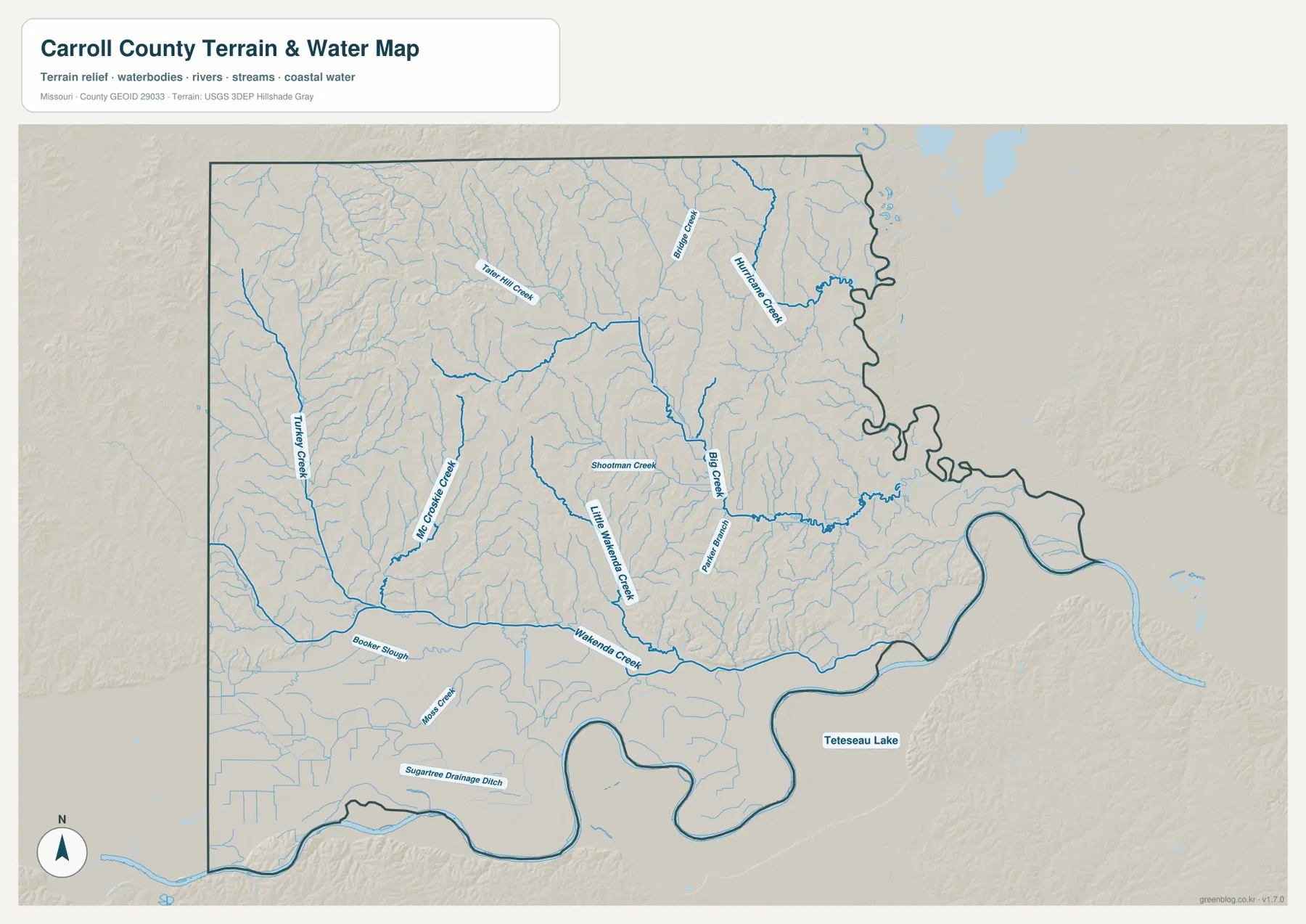
This map is intended for geographic reference, not regulatory flood determination. It does not show FEMA flood zones, real-time stage, levee condition, legal water boundaries, parcel lines, or navigational depth. Anyone making an insurance, development, emergency-planning, or property decision near the Missouri River, Grand River, Wakenda Creek, or other channels should use the latest official flood and water information.
Higher Northwestern Ridges Descend to the Missouri and Grand River Bottomlands
The elevation map gives Carroll County a very different appearance from the simpler road map. Browns and oranges dominate parts of the northwest, where a dense pattern of narrow valleys breaks up the higher ground. Similar ridge-and-valley texture continues through much of the northern half. Moving south and east, greener colors become more common and the surface opens into broader low terrain near the major rivers.
The legend reports an actual county elevation range of roughly 190 to 304 meters, with a mean near 225 meters. A difference of about 114 meters is not mountainous on a national scale, yet it is more than enough to create noticeable local relief. Small streams cut into the uplands, leaving repeated ridges between them, while Wakenda Creek and Big Creek occupy lower corridors that lead toward the river plain.
The Missouri River bottomland is the broadest low zone on the map. It follows the large bends along the southern edge and widens toward the east. The Grand River side adds another extensive low corridor, and the confluence area near the southeast is among the lowest-looking parts of the county. In contrast, the northwest shows a much tighter pattern of high and low colors because short tributaries have cut many small valleys into the uplands.
The colors are locally scaled to make differences within Carroll County easy to see. Brown does not indicate high mountains by Missouri-wide standards, and green does not automatically mean wetland or flood hazard. The map is useful for comparing ridges, valley floors, and broad bottomlands. Surveying, engineering, construction, drainage design, or parcel-level elevation work requires more precise USGS data or professional field measurements.
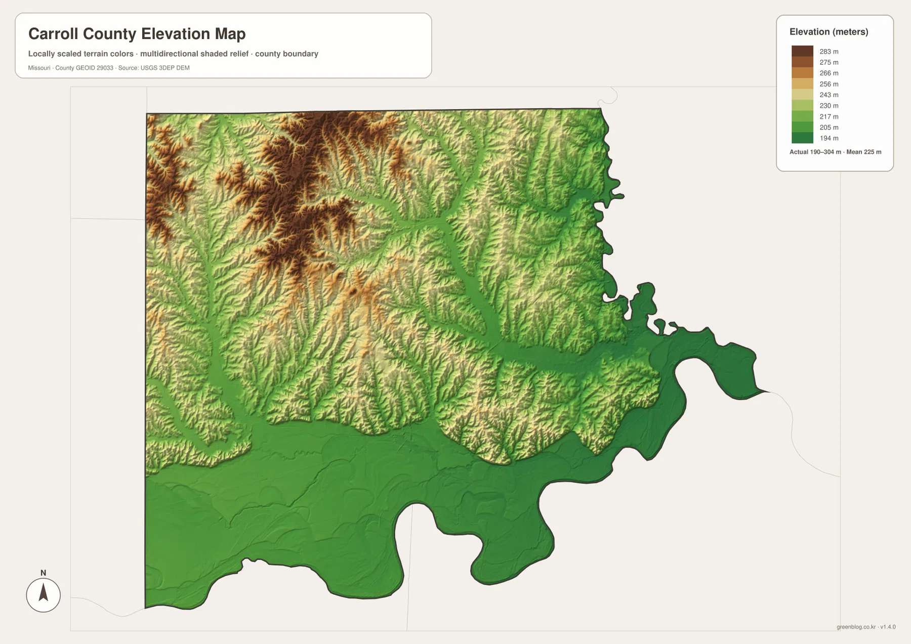
Pairing elevation with the road map also changes the way the highways are understood. U.S. 65 crosses a more dissected landscape in the north, then approaches lower ground south of Carrollton near the Wakenda Creek corridor. Route 24 similarly moves from the county center toward lower terrain around De Witt and the eastern river system. The highways remain visually simple lines, but the relief map shows that the land around them changes considerably from one part of the county to another.
Which Carroll County Map Works Best for Your Purpose?
Start with the general county map when you need roads, communities, and boundary context together. Carrollton and the U.S. 65-Route 24 pattern give an immediate frame of reference, and the winding eastern and southern boundary makes the river influence visible. Use the ranked city map when your main task is comparing the relative placement of Carrollton, Norborne, Hale, Bosworth, Tina, and Bogard without the distraction of smaller road labels.
For physical geography, the water and elevation maps work best as a pair. The water map names Wakenda Creek, Little Wakenda Creek, Big Creek, Hurricane Creek, and several smaller channels, while the elevation map shows the lower corridors those waterways occupy. The Missouri and Grand river bottomlands become especially clear when both maps are viewed together because the broad low surface and the major drainage framework line up.
Each original JPG is 3638 by 2572 pixels, giving more room to enlarge community names, creek labels, route numbers, and subtle terrain shading than the WebP images displayed in the article. The files work well for general geographic reference, classroom use, and print preparation. They are not substitutes for current official products covering property ownership, legal boundaries, zoning, flood insurance, road closures, surveying, or engineering.
A useful summary of Carroll County is to connect three features: the Carrollton road center, the Wakenda Creek drainage, and the broad Missouri-Grand river lowlands. The northwest is higher and more dissected, while the south and east flatten toward the large rivers. When those physical differences are added to the community and highway pattern, the county becomes much easier to understand than it would be from a road map alone.
Frequently Asked Questions
Why is Carrollton the most useful reference point on these maps?
Carrollton is the county seat and sits near the meeting of U.S. 65 and Route 24, with the Route 10 corridor approaching from the west. That central road position makes it easy to describe the directions of Norborne, Hale, Tina, Bosworth, and De Witt. The ranked community map also places Carrollton first among the six selected places, so it works well as both a transportation and settlement reference.
Why does Wakenda Creek appear prominently in a Carroll County map guide?
Wakenda Creek crosses the southern interior near Carrollton and drains toward the Missouri River lowlands. USGS maintains a monitoring location on the creek at Carrollton. The name also has a local historical connection: the county’s official history says Wakenda was considered as the county name before Carroll County was chosen in 1833.
Do the green areas on the elevation map represent official flood zones?
No. Green represents relatively lower elevation within this locally scaled terrain map, not a FEMA flood classification. The Missouri and Grand river bottomlands are visibly low, but actual flood risk depends on river stage, levees, rainfall, drainage, and official flood mapping. Use current FEMA, USGS, and local sources for safety, insurance, development, or property decisions.
Map File Information
The ZIP contains the original high-resolution JPG files for the county map, ranked six-community map, terrain-and-water map, and elevation map shown in this article. The originals are larger than the on-page WebP images and are useful for closer viewing and print preparation.
- Included Files: 4 maps
- File Type: JPG
Related Maps
Sources and References
- Carroll County Missouri – At a Glance: official county overview covering Carrollton, transportation, and the Missouri/Grand river setting.
- Carroll County Missouri Courthouse: official county history, organization date, naming background, and courthouse information.
- USGS – Wakenda Creek at Carrollton, MO: official monitoring-location information for Wakenda Creek.
- U.S. Census Bureau TIGER/Line Shapefiles: official geographic boundary and transportation data.
- USGS National Hydrography: official river, stream, lake, and related hydrography data.
- USGS 3D Elevation Program: official elevation and terrain-surface data.
Green Map creates custom-edited map images using open geographic data sources such as geoBoundaries, Natural Earth, OpenStreetMap, and government open data. These maps are edited visual materials, not raw data files, and are provided for education, documents, presentations, and graphic reference.