Todd County covers a long north-south slice of central Minnesota, and its geography becomes much easier to follow once Long Prairie is used as the starting point. U.S. 71 runs north from the city toward Browerville, Clarissa, Eagle Bend, Bertha, and Hewitt, while Grey Eagle sits well to the southeast among a much denser field of lakes and small streams. The maps on this page separate roads and communities from water features and terrain so each part of the county can be read without too much clutter. Full-resolution JPG versions of all four maps are also available in the downloadable ZIP below.
The county changes noticeably from west to east. Long Prairie and the U.S. 71 towns form the clearest chain of settlements, but the southeastern quarter around Grey Eagle, Burtrum, and Swanville is less dependent on that highway and contains many more lakes. The elevation map adds another contrast: western and northwestern Todd County is generally higher and more ridged, while much of the east lies lower. Looking at those differences together is more useful than treating the road, water, and elevation maps as unrelated illustrations.
Table of Contents
Follow U.S. 71 from Long Prairie toward Browerville, Clarissa, and Bertha
On the county map, U.S. 71 is the easiest line to follow. It enters from the south, passes through Long Prairie, continues to Browerville, then reaches Clarissa, Eagle Bend, Bertha, and Hewitt farther north. Because so many named places appear along the same road, the highway provides a simple way to learn the western half of Todd County. MN 27 crosses Long Prairie from west to east, while U.S. 10 and MN 210 become important near Staples at the northern edge.
The southern half is more varied. Osakis appears close to the southwest boundary, with Interstate 94 nearby, while Grey Eagle, Burtrum, and Swanville occupy the southeast away from U.S. 71. MN 287 and other state and county roads handle much of the connection in that area. This is why a visitor who knows only the U.S. 71 sequence still needs a second reference for southeastern Todd County: the highway chain explains many towns, but it does not explain the entire county.
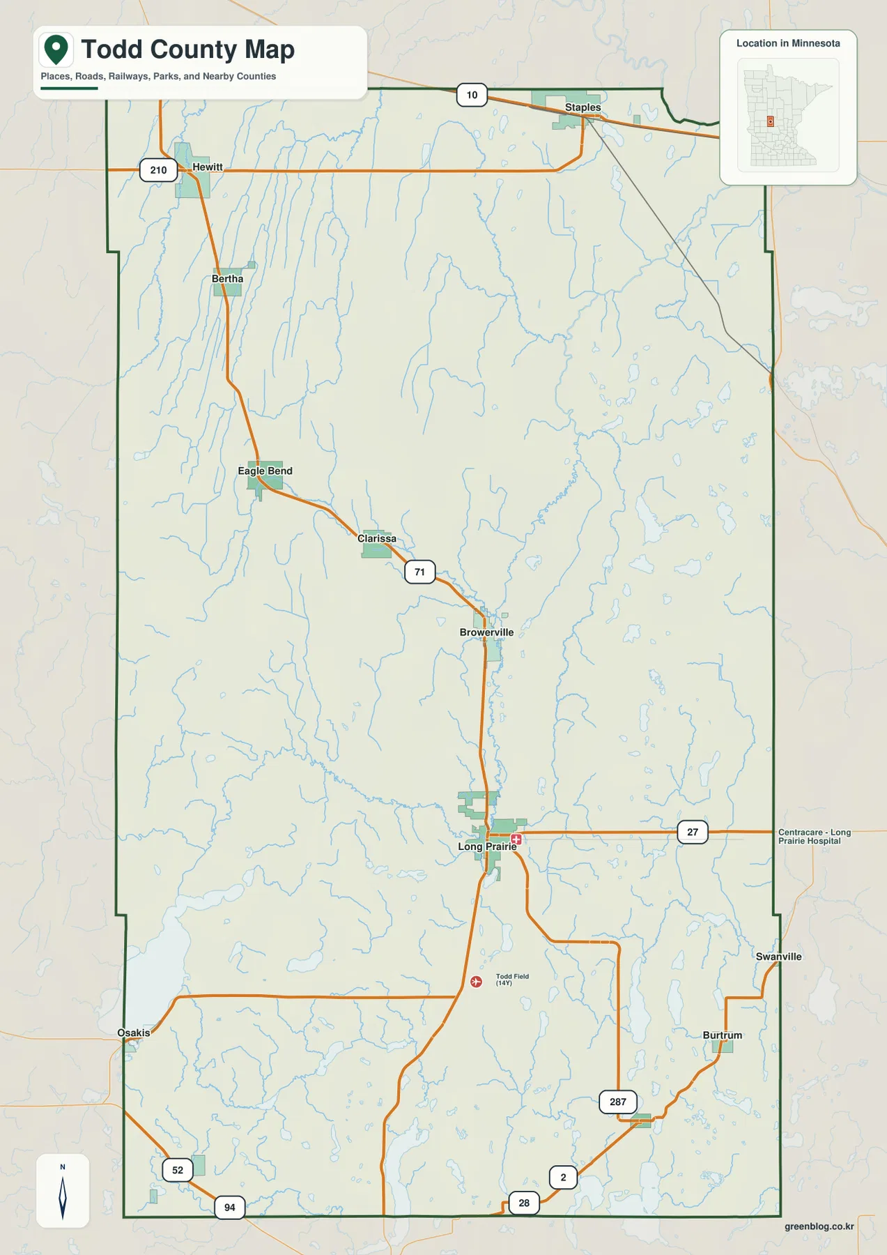
The surrounding county names provide another quick orientation check. Douglas and Otter Tail counties lie to the west, Wadena and Cass are to the north, Morrison is east, and Stearns is south. The boundary bends around the Staples area but is much straighter along long sections of the east and west sides. These county lines are suitable for general geographic reference only; they are not parcel boundaries and should not be used for legal property decisions.
Six major cities form a long north-south sequence, with Grey Eagle apart in the southeast
The city map strips away most road labels and emphasizes six communities. Long Prairie is ranked first on the supplied image, followed by Browerville and Clarissa. Eagle Bend and Bertha sit farther north, and Grey Eagle is separated from the others in the southeast. That arrangement is one of the most useful things to learn about Todd County: its better-known towns are spread across a long distance instead of forming one dense urban group.
Long Prairie and Browerville are relatively close to each other, and both are easy to locate near U.S. 71 and the Long Prairie River. North of Browerville, Clarissa, Eagle Bend, and Bertha appear one after another with wider gaps between them. Grey Eagle requires a different mental reference because it is not part of that highway sequence. If the full county map feels crowded, this simplified city view is a good first step before adding roads, rivers, and lakes.
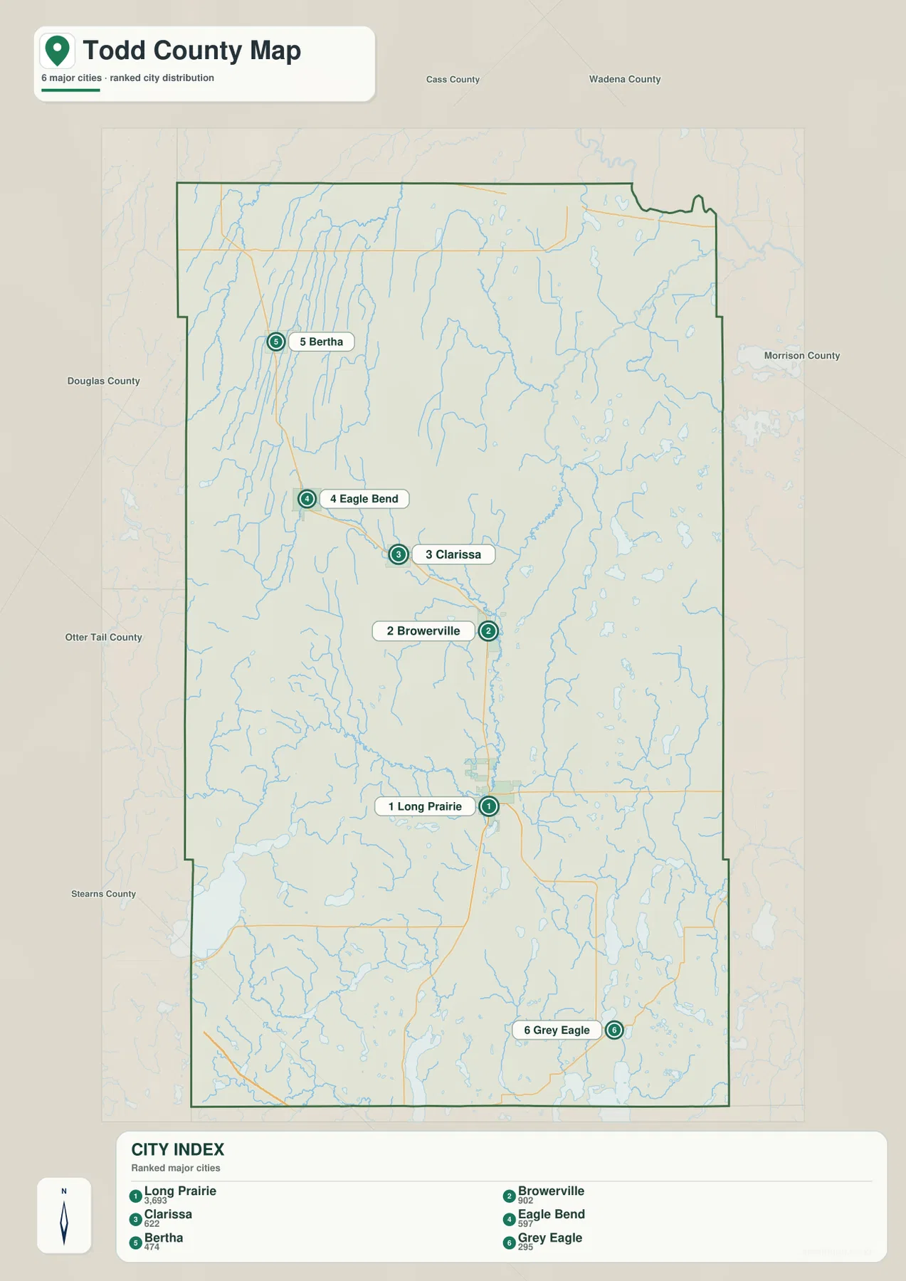
The city index printed on the supplied map lists Long Prairie at 3,693, Browerville at 902, Clarissa at 622, Eagle Bend at 597, Bertha at 474, and Grey Eagle at 295. Those figures are useful as labels for the map edition, but they should not be treated as a guarantee of the latest population count. For current demographic work, a fresh Census source is the better choice. Here, the value of the city map is primarily positional: it shows where the six named places sit relative to one another.
Long Prairie River cuts through the center while the southeast fills with lakes
The water map shifts attention away from highways. Long Prairie River is the dominant named river through the middle of the county, entering from the northeast, winding southward, and bending toward the southwest. In the northwest, Wing River, Little Partridge River, and Partridge River form a second group of long watercourses. Crow Wing River touches the northern edge, while Turtle Creek and Little Swan River appear on the eastern side.
Lakes become much more conspicuous in the southern and eastern parts of Todd County. Lake Osakis reaches the southwest boundary, Maple Lake sits farther east, and Long Lake and Big Birch Lake stand out in the southeast. Numerous smaller lakes are scattered across the eastern half as well. This makes the area around Grey Eagle look very different from the U.S. 71 towns to the northwest, where long stream valleys and higher ridges are more prominent than large clusters of lakes.
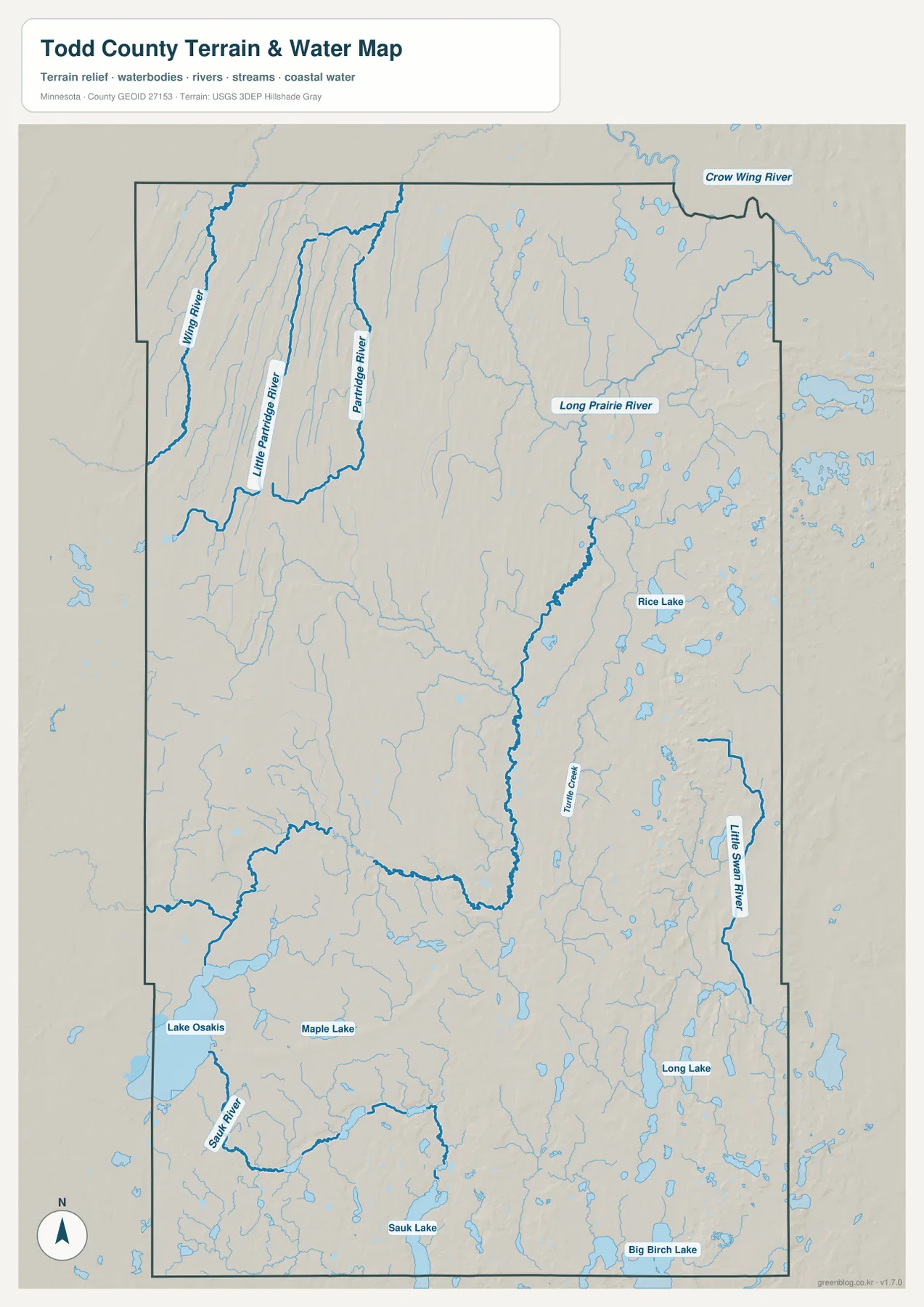
Comparing the road and water maps helps explain why Long Prairie is such a useful landmark. U.S. 71 runs through the city in a relatively direct north-south path, while Long Prairie River bends through the same general area and then continues on a much less straight course. Farther north, tributaries multiply; farther southeast, the map becomes increasingly lake-dominated. This water map is meant for location reference, not for flood risk, water depth, water quality, or boating navigation. Current agency information is still necessary for recreation and safety decisions.
Western ridges stand above lower eastern terrain
The elevation legend shows an actual county range of about 355 to 459 meters and a mean near 404 meters. Browns and tans cover much of the west and northwest, while greens become more common toward the east. The difference between the lowest and highest parts exceeds 100 meters, enough to create a very visible county-scale contrast even though Todd County is not mountainous. Long, narrow ridges are particularly noticeable near the western edge.
The Long Prairie River follows lower ground through the central part of the elevation image, and smaller streams occupy many of the narrow valleys cut into the western ridges. The south contains a more intricate mix of low basins and small rises around Lake Osakis and other lakes. On the eastern side, broad lower areas are interrupted by scattered ridges. Viewing the elevation and water maps together makes those relationships easier to see because many rivers and lakes occupy the lower parts of the terrain.
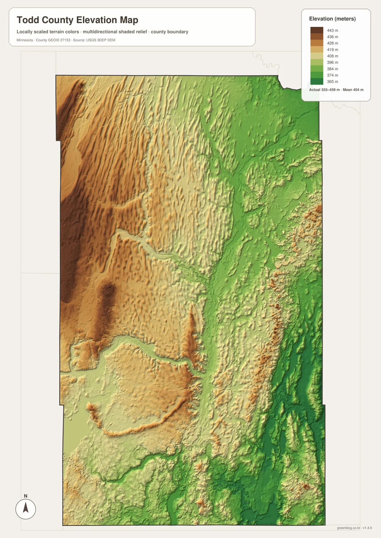
The elevation image is designed for broad county comparison. It is not a survey, engineering surface, or precise source for the elevation of a driveway, building site, culvert, or property corner. Those uses require original elevation data or a professional survey. On this page, the map is most valuable for showing the major west-to-east difference and for placing the Long Prairie River and southern lake basins within that larger terrain.
Use Long Prairie, Grey Eagle, and Lake Osakis as three different reference points
Long Prairie shows how roads, water, and relief overlap in one place. On the county map it is the junction of U.S. 71 and MN 27; on the water map the nearby Long Prairie River becomes the stronger visual feature; on the elevation map the city sits near lower ground associated with the river valley. Switching between the maps changes what stands out without changing the location, which is useful when preparing a school report or a local geography presentation.
Grey Eagle offers a different example. It lies away from the U.S. 71 chain and closer to the dense group of southeastern lakes. That makes the water map more informative than the highway map for explaining its surroundings. Lake Osakis near the southwest corner provides a third comparison: the road map emphasizes Osakis and nearby Interstate 94, the water map emphasizes the large lake and Sauk River, and the elevation map shows the transition between higher western ground and lower southern basins.
These three reference points also suggest which map to choose. The county map is best when places and roads need to appear together. The city map is cleaner when the goal is to compare major communities without extra road detail. The water map is the natural choice for Long Prairie River, Wing River, Lake Osakis, Long Lake, and Big Birch Lake. The elevation map is the clearest option for showing the higher west and lower east.
Download the full-resolution maps for printing or closer viewing
The WebP images on this page are sized for convenient browsing. The ZIP download contains the same four maps as 3638×2572-pixel JPG originals, which are better suited to printing, enlargement, and slide use. The archive includes a county-and-road map, a major-city map, a water map, and an elevation map, so you can use only the version that fits your project or combine two maps when a single image does not provide enough context.
These files work well for classroom handouts, county introductions, personal reference, and presentations. They are not replacements for live navigation, legal boundary records, flood studies, or engineering surveys. Roads can change, local conditions around lakes can change, and property questions require official records. For general geography, however, the set provides a practical way to compare Todd County’s towns, highways, rivers, lakes, and terrain without overloading one map.
Frequently Asked Questions
What is the easiest road to follow from Long Prairie to the northern towns?
U.S. 71 is the clearest guide. It runs north from Long Prairie through or near Browerville, Clarissa, Eagle Bend, Bertha, and Hewitt. Near the northern edge, U.S. 10 and MN 210 become important around Staples. The map is useful for orientation, but current navigation should still be used for actual driving because construction, weather, and local road conditions can change.
Why does the Grey Eagle area look different from the U.S. 71 towns?
Grey Eagle is in the southeast, away from the main U.S. 71 sequence, and the surrounding area contains many more lakes and small streams. Long Lake and Big Birch Lake are easy to see nearby, while the western and northwestern parts of Todd County show more long ridges and river valleys. The water map makes this contrast especially clear.
How much elevation difference appears on the Todd County map?
The supplied legend shows approximately 355 to 459 meters, with a mean around 404 meters. Higher ridges are concentrated in the west and northwest, while much of the east is lower. That range is useful for county-scale comparison but should not be used as precise elevation data for a property, road project, or engineering calculation.
Map File Information
The ZIP contains the original high-resolution JPG versions of the Todd County county map, city map, water map, and elevation map used on this page.
- Included Files: 4 high-resolution JPG maps
Related Maps
Sources and References
- Todd County official website — county government and local information
- U.S. Census Bureau TIGER/Line Shapefiles — county boundaries, roads, and place reference
- USGS National Hydrography — river, stream, and lake reference
- USGS 3D Elevation Program — elevation and terrain reference
Green Map creates custom-edited map images using open geographic data sources such as geoBoundaries, Natural Earth, OpenStreetMap, and government open data. These maps are edited visual materials, not raw data files, and are provided for education, documents, presentations, and graphic reference.