Stearns County stretches across central Minnesota from the St. Cloud urban area on the east to a much broader landscape of towns, lakes, and farmland in the west. St. Cloud, Waite Park, St. Joseph, and Sartell form a close eastern cluster, while I-94 carries the main line of communities northwest through Avon, Albany, Melrose, and Sauk Centre. These maps separate roads and boundaries, major-city distribution, water features, and elevation so the county can be read in layers. The high-resolution JPG originals used for the page can also be downloaded together from the map file box below.
The county is especially easy to recognize by three features: the dense road network around St. Cloud, the long course of the Sauk River through the interior, and the contrast between lower eastern valleys and higher western ground. Paynesville and Lake Koronis provide a second strong reference in the southwest, while Sauk Centre anchors the northwest. The supplied elevation map lists an actual range of roughly 240 to 443 meters, with an average near 365 meters, so the water and relief maps reveal differences that are much less obvious on a road map alone.
Table of Contents
I-94 strings together the towns from St. Cloud toward Sauk Centre
The clearest transportation pattern on the county map is I-94. It enters the St. Cloud area on the east, runs near St. Joseph, and then continues northwest through Avon and Albany toward Melrose and Sauk Centre. Because Stearns County is broad from east to west, this route gives the reader a simple way to organize a long list of communities. Rather than treating the county as one large block, it is useful to begin at St. Cloud and follow the interstate town by town toward the northwest. The spacing between places also increases as the route leaves the denser eastern side.
St. Cloud has the most complicated road setting on the map. MN 15 provides a north-south route through the eastern side, while MN 23 connects the St. Cloud area with Cold Spring and then continues toward Paynesville. Waite Park and St. Joseph sit close by, and Sartell lies farther north along the eastern edge. This concentration means the eastern part of the county has several overlapping travel directions rather than a single corridor. The map is useful for seeing how the nearby cities fit around the major roads before checking a current navigation service for travel times, closures, or traffic.
The western half relies on a different set of reference roads. U.S. 71 runs through the Sauk Centre area and continues south toward Brooten, while MN 28 crosses near Sauk Centre. Farther south, MN 23 is the most useful line for finding Paynesville and following the route back toward Cold Spring and St. Cloud. Looking at these roads together prevents the western part of Stearns County from being reduced to a continuation of I-94. Sauk Centre and Paynesville occupy different parts of the county and are connected to the eastern urban area by different road patterns.
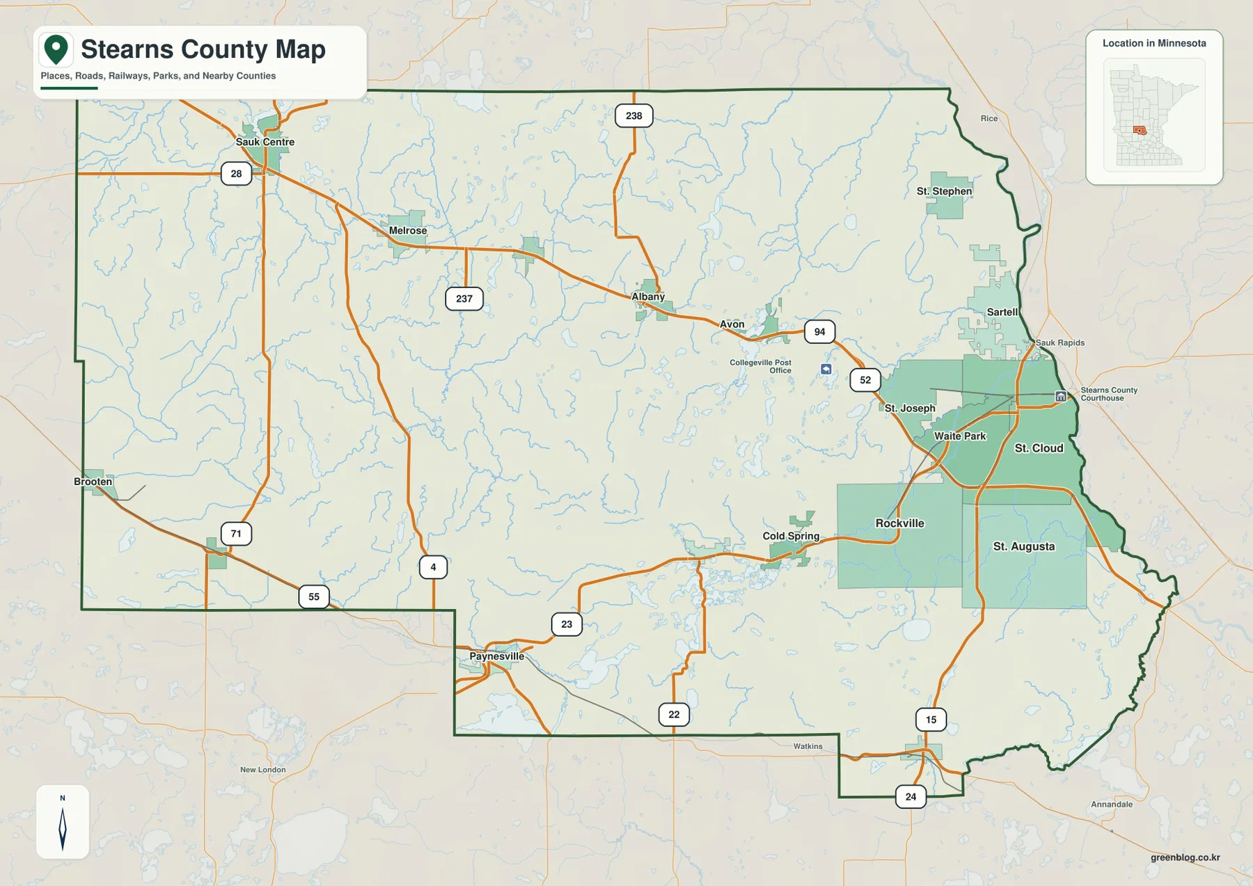
This boundary-and-road map works best as an orientation sheet rather than a navigation product. It shows where cities sit in relation to county edges and which major roads connect the larger communities, but it does not represent live traffic, temporary construction, or every local street. The contrast between the crowded eastern network and the more widely spaced western towns is more important here than precise driving details. For a reader unfamiliar with central Minnesota, the map also shows why St. Cloud functions as the most obvious eastern gateway into the county.
The major-city index is concentrated around St. Cloud but reaches west to Sauk Centre
The city map removes much of the road detail and highlights six ranked places. Its index lists St. Cloud first, followed by Sartell, Waite Park, St. Joseph, Sauk Centre, and Cold Spring. Those figures reflect the dataset used to build the map and should not be treated as a replacement for the newest official population estimates. Their main value here is geographic: four of the six highlighted places form a compact cluster on the eastern side, while Sauk Centre and Cold Spring provide separate reference points farther west.
St. Cloud, Waite Park, and St. Joseph sit close enough together that their markers form a tight group, and Sartell lies just to the north. That pattern matches the road map, where I-94, MN 15, and MN 23 create a dense network around the same area. The simplified city view makes the concentration easier to see because smaller roads and most place labels are removed. If the goal is to explain where the county’s largest named communities are located, this view is cleaner than the general map.
Sauk Centre is visually isolated in the northwest compared with the eastern cluster. It therefore works as a useful anchor for the broad western and northwestern portion of the county. Cold Spring occupies a different position in the south-central area along the broader St. Cloud-to-Paynesville corridor. The city map does not imply that unranked communities such as Melrose, Albany, Avon, or Paynesville are unimportant; it simply narrows the page to six major-city markers. Readers who need the full settlement sequence should return to the road map after using this simplified view.
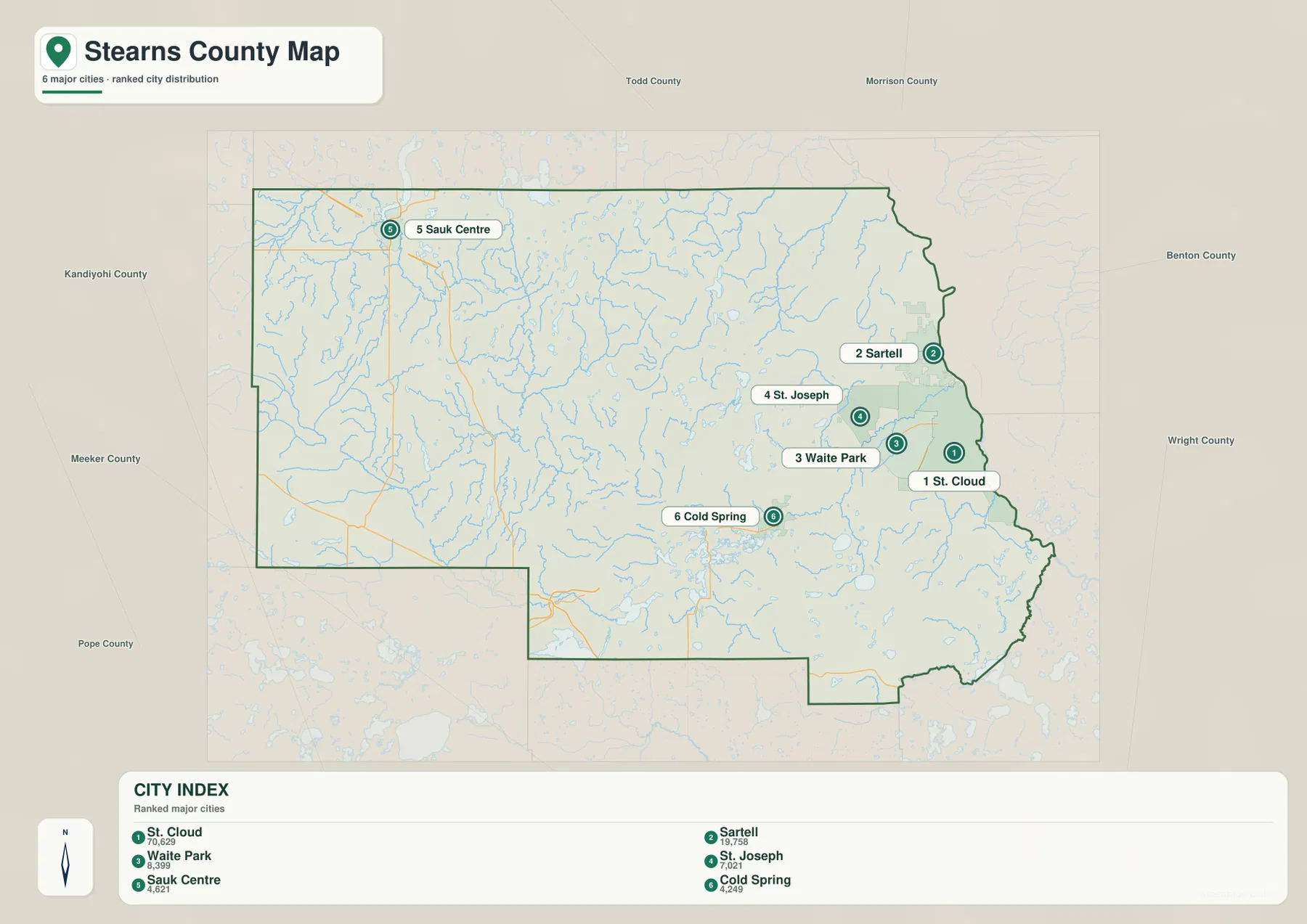
The county outline also matters when reading the city distribution. Stearns County is broad and irregular rather than centered around a single middle point, so the eastern cluster does not sit near the geometric center of the county. Large areas extend far to the west and southwest from St. Cloud. This is why the general road map and the city index answer different questions: one explains the network of many communities across the county, while the other emphasizes where the largest highlighted places are concentrated.
The Sauk River crosses the interior while Lake Koronis anchors the southwest
The water map gives Stearns County a very different visual structure. The Sauk River is the dominant interior river, beginning near the Sauk Lake area in the northwest and bending through the county toward St. Cloud. Cedar Lake and Big Birch Lake are labeled near the northwestern part of the map, while numerous smaller lakes and tributaries fill the interior. Following the Sauk River provides a natural counterpart to following I-94: the road explains the town sequence, and the river explains one of the county’s most important drainage paths.
North and east of the central Sauk River corridor, the map labels South Two River and Spunk Creek, then shows the Watab River and South Fork Watab River closer to the eastern side. Long Lake is another useful feature in the east-central interior. These waters are easier to see here than on the general map because roads and settlement labels have been reduced. The result is a clearer picture of how many separate streams and lakes occupy the space between the larger towns.
The southwest has its own strong water reference. Lake Koronis appears near Paynesville, with Rice Lake and the North Fork Crow River nearby. The county’s official parks list includes Lake Koronis Regional Park and Two Rivers Lake County Park, which reinforces the importance of lakes and rivers as recognizable local features beyond the map itself. That does not mean every shoreline or recreation site is shown here; the water map is a geographic reference layer, and visitors should use official park information for current access rules, facilities, or recreation details.
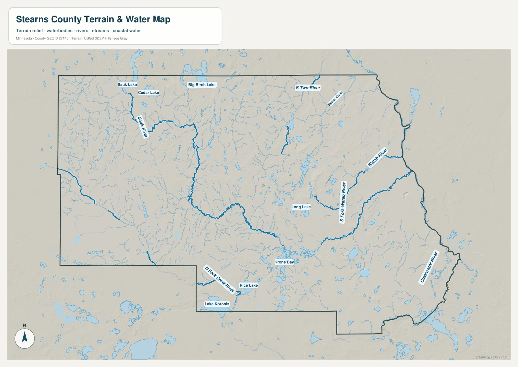
The Clearwater River is also labeled near the southeastern edge. It is not as visually dominant as the Sauk River, but it helps explain the low drainage terrain near that part of the county. A practical way to use this map is to start with four anchors—Sauk River, Lake Koronis, Watab River, and North Fork Crow River—and then add the smaller lakes and creeks around them. That approach is more useful than trying to interpret every blue line at once, especially in a county where water features are spread across a large area.
This layer should not be used as a flood map, parcel map, depth chart, boating chart, or legal access map. It shows the relative location of water bodies and drainage features, not current flood risk, water quality, flow conditions, or property rights. Those questions require current agency products. For this article, the purpose is to connect the visible river and lake pattern with the towns and elevation shown in the other maps.
Relief rises toward the west and northwest while river valleys stay lower
The elevation map reports an actual county range of about 240 to 443 meters and a mean near 365 meters. The broadest visual contrast is between higher brown-toned ground in the west and northwest and lower green terrain toward the east and southeast. Stearns County can look relatively level on a road map, but the shaded relief reveals many ridges, shallow basins, and small valleys. The difference is large enough to explain why watercourses appear as long lower corridors through otherwise higher ground.
The Sauk River valley is especially clear. A green lower band winds through the central portion of the county toward the east, matching the bends seen on the water map. Higher land rises on both sides in many places, so the river is not simply drawn across a uniform plain. The North Fork Crow River and the Lake Koronis area in the southwest also occupy lower terrain relative to nearby uplands. Comparing the water and elevation maps side by side makes these relationships much easier to see.
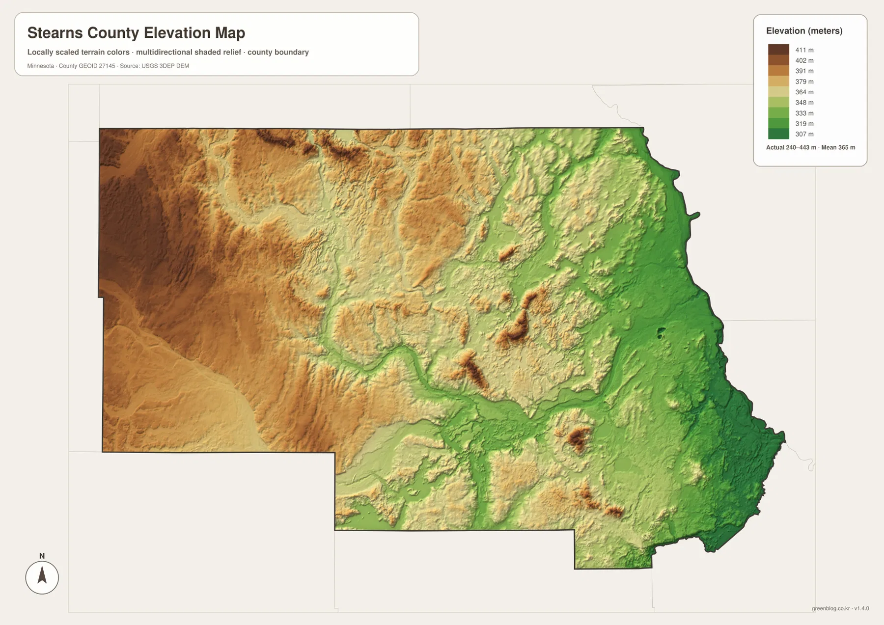
The eastern side around St. Cloud and Sartell contains a larger share of the lower colors, consistent with the major river valleys near the county edge. Moving west, higher colors become more common, but the change is not a smooth staircase. Small low corridors cut through high ground, and isolated hills rise from areas that otherwise look moderate. It is therefore best to describe the county as having a broad west-to-east contrast with many local variations rather than claiming that elevation changes evenly in one direction.
The elevation surface is generalized for countywide comparison. It is not a survey-grade product and should not be used to establish a building-site elevation, drainage design, engineering grade, or legal boundary. USGS 3D Elevation Program data or a professional survey is more appropriate when exact measurements matter. Here the map is most useful for understanding why the Sauk River follows a low route through the interior and why the western half appears more elevated than the St. Cloud side.
Choosing the best map for St. Cloud, Sauk Centre, or Paynesville
For St. Cloud and the nearby eastern cities, start with the general county map. I-94, MN 15, and MN 23 quickly establish the relationship among St. Cloud, Waite Park, St. Joseph, and Sartell. The city map then strips away extra detail and shows how strongly the major-city index is concentrated near the eastern edge. Adding the water layer reveals the Sauk and Watab river systems around the urban area, while the elevation layer explains why much of this side appears lower than the western uplands.
Sauk Centre is easier to understand with a different sequence. Locate it first on the general map at the meeting area of I-94, U.S. 71, and MN 28, then switch to the water map to find Sauk Lake and the beginning of the long Sauk River corridor. The elevation map shows that the broader northwest sits within higher terrain than the St. Cloud side. This three-map comparison gives Sauk Centre a much clearer geographic context than a city marker alone.
Paynesville and the southwest are best anchored by MN 23 and Lake Koronis. On the general map, Paynesville sits in the county’s stepped southwestern extension. On the water map, Lake Koronis becomes the dominant reference, with Rice Lake and the North Fork Crow River nearby. The elevation layer adds the valleys and surrounding higher ground. This is a useful example of why different sections of Stearns County need different visual anchors; I-94 is excellent for the northwest route but not the most intuitive way to explain the Lake Koronis area.
The four supplied maps are therefore complementary rather than interchangeable. The general map is best for roads, boundaries, and the full settlement network. The city map simplifies the page to the six indexed major communities. The water map focuses on the Sauk River, Lake Koronis, Watab River branches, and the county’s many smaller lakes and streams. The elevation map compares the roughly 240–443 meter range and shows how valleys relate to higher ground. For a printed handout or presentation, choosing the layer that matches the question usually produces a clearer result than trying to show every type of information on one page.
High-resolution Stearns County map files for print and close viewing
The WebP images in the article are reduced previews designed for quick loading. The original JPG files are more useful when small road labels, lake names, and local place names need to remain readable at a larger size. The download archive contains the county road-and-boundary map, major-city map, terrain-and-water map, and elevation map, each at 3638×2572 pixels. That resolution is useful for enlarged viewing, classroom material, presentation slides, and personal reference where the web preview may be too small.
If only one file is needed, the general map carries the broadest mix of information. The city map is cleaner when the task is to compare major settlement locations, while the water map is the better choice for the Sauk River, Lake Koronis, and stream network. The elevation map is most useful when the distinction between western uplands and lower river corridors matters. None of the files should be substituted for legal parcel records, current navigation, flood determinations, or engineering surveys.
Frequently Asked Questions
What is the easiest way to follow the towns from St. Cloud to Sauk Centre?
Use I-94 as the main reference on the general map. Starting at the St. Cloud and St. Joseph side, the route continues northwest past Avon and Albany to Melrose and Sauk Centre. The city map is useful for comparing the largest highlighted communities, but the general map is better for seeing the full town sequence and the roads that connect it.
Where are the Sauk River and Lake Koronis on the Stearns County maps?
The Sauk River begins near the Sauk Lake area in the northwest and winds across the interior toward St. Cloud. Lake Koronis is a large water reference near Paynesville in the southwest, with Rice Lake and the North Fork Crow River nearby. Because the two features occupy different parts of the county, the water map is the clearest way to compare their locations.
What does the elevation map show most clearly?
The map’s actual elevation range is about 240 to 443 meters, with a mean near 365 meters. Higher terrain is widespread in the west and northwest, while the Sauk River corridor and much of the eastern St. Cloud side appear lower. The layer is intended for countywide comparison, not precise site surveying, so exact project elevations should come from USGS data or professional survey work.
Map File Information
The ZIP contains the high-resolution JPG originals for the Stearns County general map, city map, water map, and elevation map used on this page.
- Included Files: 4 high-resolution JPG maps
Related Maps
Sources and references
- Stearns County official website — county government and local information
- Stearns County Parks — county parks including Lake Koronis and Two Rivers Lake
- U.S. Census Bureau TIGER/Line Shapefiles — county boundaries, roads, and place references
- USGS National Hydrography — rivers, streams, and lakes
- USGS 3D Elevation Program — elevation and terrain reference
Green Map creates custom-edited map images using open geographic data sources such as geoBoundaries, Natural Earth, OpenStreetMap, and government open data. These maps are edited visual materials, not raw data files, and are provided for education, documents, presentations, and graphic reference.