Owatonna is the easiest place to orient yourself in Steele County. Interstate 35 runs north–south through the city while U.S. 14 crosses the county from west to east, so the road map quickly explains why Owatonna serves as the main reference point. Medford lies close to the north, whereas Ellendale and Blooming Prairie occupy separate parts of the southern half. The Straight River adds a natural reference through the middle of the county, and the elevation layer shows that the land generally rises toward the east. High-resolution JPG originals for the maps on this page are available in the ZIP download below.
The maps are most useful when read together rather than as four unrelated views. The county map establishes roads and municipal locations, the city map makes the spacing from Owatonna easier to compare, the water map follows the Straight River and nearby creeks, and the elevation map explains the lower river corridor and higher eastern terrain. That combination makes Steele County easy to read at county scale without treating the page as a navigation, flood, or survey product.
Table of Contents
Roads converge on Owatonna
The county map makes Owatonna the most obvious starting point. Its urban area occupies the north-central part of Steele County, with I-35 running almost straight through the city from south to north. US 14 crosses the county from west to east just south of the core of Owatonna, creating the county’s most visible highway junction. From this intersection, the map can be read in four broad directions: north toward Medford, west toward Waseca County, east toward Dodge County, and south toward the rural townships and the two southern towns.
Several county roads and local routes cluster around Owatonna. Labels such as 19, 18, and 35 appear near the city, and the map also marks the Steele County Courthouse and Owatonna Hospital. Rail lines pass through the same general area, reinforcing the role of Owatonna as a transportation center rather than an isolated point on a single highway. The map does not measure traffic volumes or travel times, but it does show how multiple transportation features converge around the city before spreading into a much more open rural road network.
Medford sits immediately north of Owatonna along the I-35 corridor. Its urban footprint is smaller, yet it is positioned close enough that the two places form the tightest city pairing shown on the supplied connection map. Small streams branch across the land east and west of Medford, so the town is also useful when comparing the road map with the water map. For someone unfamiliar with the county, following I-35 north from Owatonna is the simplest way to locate Medford before examining the surrounding rural roads.
The southern half of the county looks different. Ellendale is located in the southwest near MN 30 and a set of north-south county roads, while Blooming Prairie is close to the southeastern boundary near US 218 and other local routes. They are not lined up behind Owatonna on a single highway. Instead, they occupy opposite sides of the southern county, which gives Steele County a pattern of one dominant north-central city and smaller southern centers spread across a wider area. This separation is important when reading the city map because straight-line distance alone does not explain the road choices needed to reach each place.
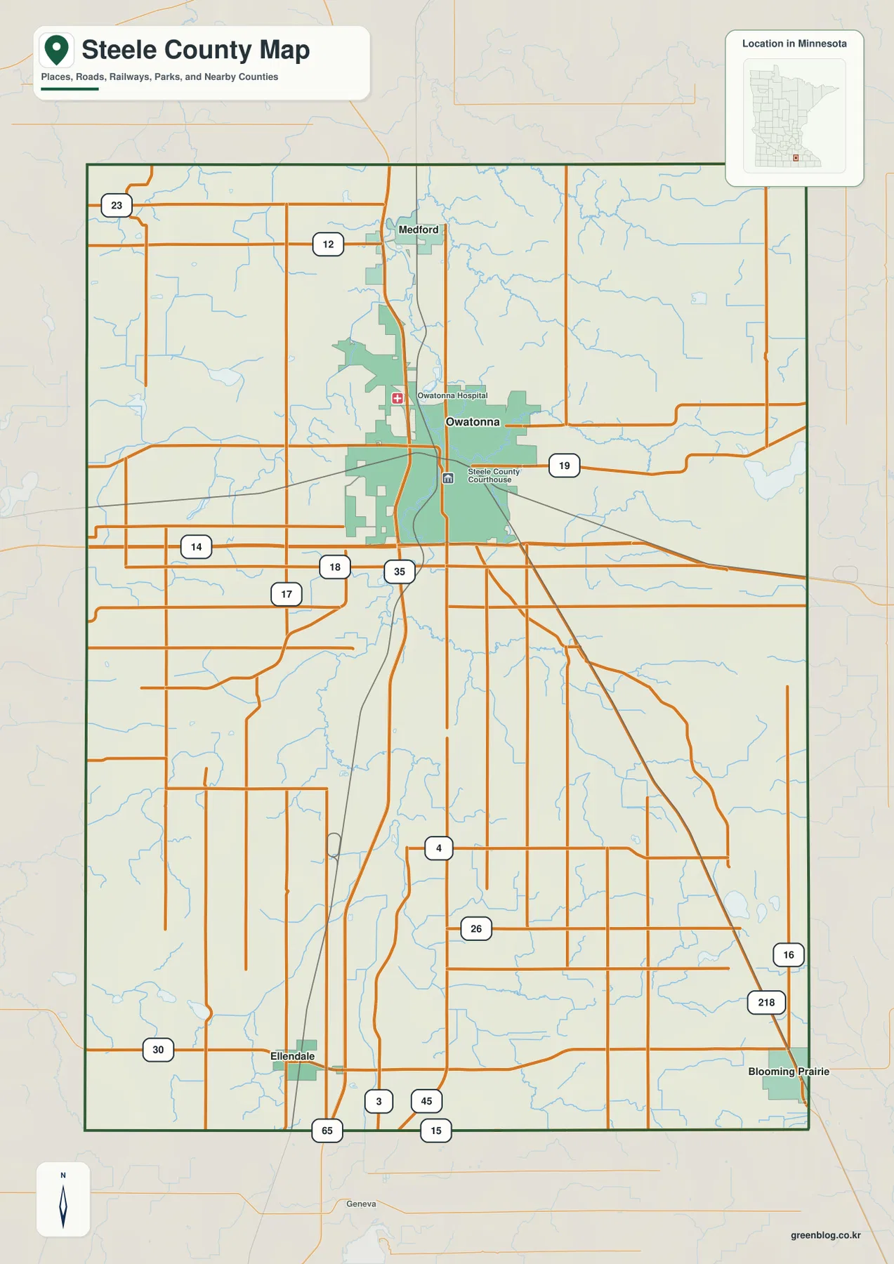
This county map is best used for general orientation. It combines named places, primary roads, railways, county boundaries, and selected landmarks in one view. The line widths and colors should not be interpreted as live traffic conditions, construction status, or legal road classifications beyond what is actually labeled. For navigation, drivers should use current road information. For geographic study, however, the map provides a strong overview of where the towns sit and how the highway grid relates to the county boundary and neighboring counties.
Medford sits close to Owatonna while two towns spread south
The city-connections map strips away much of the detail and focuses on Owatonna, Blooming Prairie, Medford, and Ellendale. The index printed on the map lists Owatonna at 26,498, Blooming Prairie at 1,843, Medford at 1,257, and Ellendale at 754. These values reflect the source used when the map was produced, so they are most useful for relative comparison rather than as a substitute for the latest official population estimates. The visual message is straightforward: Owatonna is much larger than the other three towns and sits near the center of their distribution.
Medford is shown about 5 miles from Owatonna in straight-line distance, making it by far the closest of the three comparison towns. Both places lie along the same north-south side of the county, and I-35 reinforces that relationship on the county map. Ellendale is listed about 16 miles southwest of Owatonna, while Blooming Prairie is about 18 miles to the southeast. Those similar distances place the two southern towns in roughly the same broad ring around Owatonna even though they occupy opposite sides of the county.
The connecting lines on this map are not driving routes. They are direct-distance guides intended to make the separation between towns easy to compare. A real trip from Owatonna to Blooming Prairie or Ellendale follows the available highway and county-road network rather than a straight segment. The distinction matters because a short-looking line can still involve a different route, intersection pattern, or travel time. Used correctly, the city map gives a quick sense of geographic spacing, while the county map supplies the road detail needed to understand how those places are actually connected.
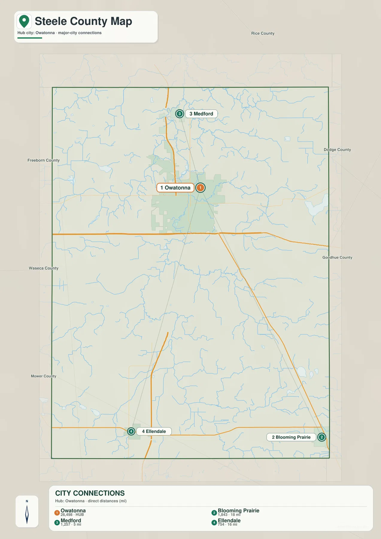
Neighboring county labels provide additional context. Rice County is above Steele County, Dodge County is to the east, Waseca and Freeborn counties are shown along the western side, and Mower County appears to the southwest. These labels help explain why Medford feels tied to the northern edge while Blooming Prairie and Ellendale sit much closer to the southern boundary. Owatonna is not exactly at the geometric center of the county, but it occupies a practical central position between the three other highlighted towns and the principal roads.
Straight River links the county’s central waterways
The water map is dominated by the Straight River, which runs through the middle of Steele County from south to north. It passes the Owatonna area and continues toward Medford, providing a natural counterpart to the I-35 corridor shown on the road map. Medford Creek joins from the north-central area, while Crane Creek approaches from the west. Maple Creek and Turtle Creek are visible to the east and southeast. Together, these waterways show that the county’s central lowland is fed by numerous smaller channels rather than by one isolated river.
Rice Lake stands out on the eastern side of the county. Steele County’s official background information identifies Rice Lake as an important local natural feature, and its position on the map makes it a useful eastern landmark away from the Straight River corridor. Mud Creek appears farther northeast, and a web of small streams crosses the surrounding high ground. When the water and elevation maps are compared, many of these stream valleys appear as lower cuts through the higher eastern terrain.
The southern part of the water map contains several additional features. The Cannon River is labeled in the southeast, while the Le Sueur River and Beaver Lake appear toward the southwest. Oak Glen Lake and Rickert Lake are shown in the southeastern quarter. These features make the southern county more varied than a simple extension of the Straight River basin. Instead of treating every blue line as part of one system, it is more useful to identify the Straight River first and then note how other lakes and rivers occupy different corners of the county.
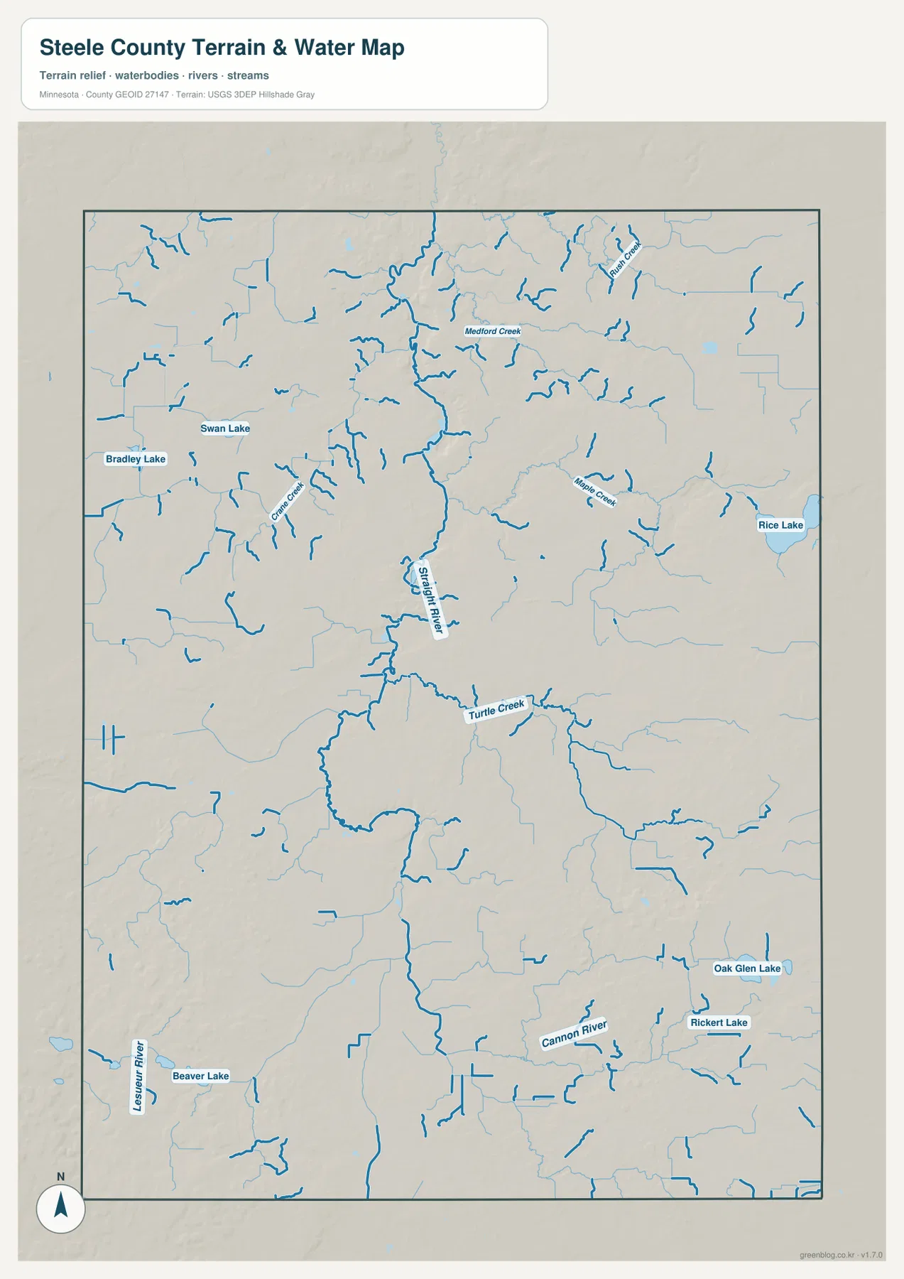
The Straight River is especially useful when matching the natural landscape to Owatonna and Medford. Its course follows the same broad north-central part of the county where the two towns are located, and the elevation map shows a lower green corridor in the same area. This does not mean the river and I-35 occupy exactly the same line, but the two features help explain why the central county appears as a recognizable corridor on multiple maps. The road map emphasizes movement through it, while the water and elevation maps reveal the physical landscape underneath.
This water map is a geographic reference, not a flood-hazard, navigation, water-quality, or depth map. It can help a reader locate rivers, creeks, and lakes, but it should not be used to determine whether a property is in a flood zone or whether a water body is safe for boating or swimming. Steele County’s parks information identifies Beaver Lake Park and the Straight River Canoe Landing as public recreation sites, so anyone planning a visit should pair the map with current official park rules and access information.
Eastern uplands stand above the Straight River valley
The elevation map reports an actual county range of roughly 323 to 413 meters, with a mean near 369 meters. Darker green colors mark the lower areas, while tan and brown colors indicate higher terrain. The most continuous low zone follows the central Straight River corridor northward through the county. By contrast, much of the eastern and southeastern side is covered by higher colors, producing the clearest broad terrain contrast visible in Steele County.
A long low valley can be traced through the Owatonna and Medford area. Comparing this shape with the water map shows that it closely follows the Straight River. Small tributary valleys branch into the lower corridor from both sides, creating a textured landscape that is more varied than the road map suggests. Owatonna occupies this broader central zone, so the city’s location makes more sense when the terrain is viewed alongside the river rather than only through highways and municipal boundaries.
The eastern county contains the most extensive higher ground. Brown and tan areas cover large sections of the northeast and southeast, with green stream valleys cutting between them. Blooming Prairie lies toward the southeastern edge of this higher landscape. The map does not show one simple ridge running across the whole county; instead, it reveals a patchwork of elevated hills and lower drainage corridors. That pattern explains why the water map contains many branching creeks even in areas that appear relatively open on the county map.
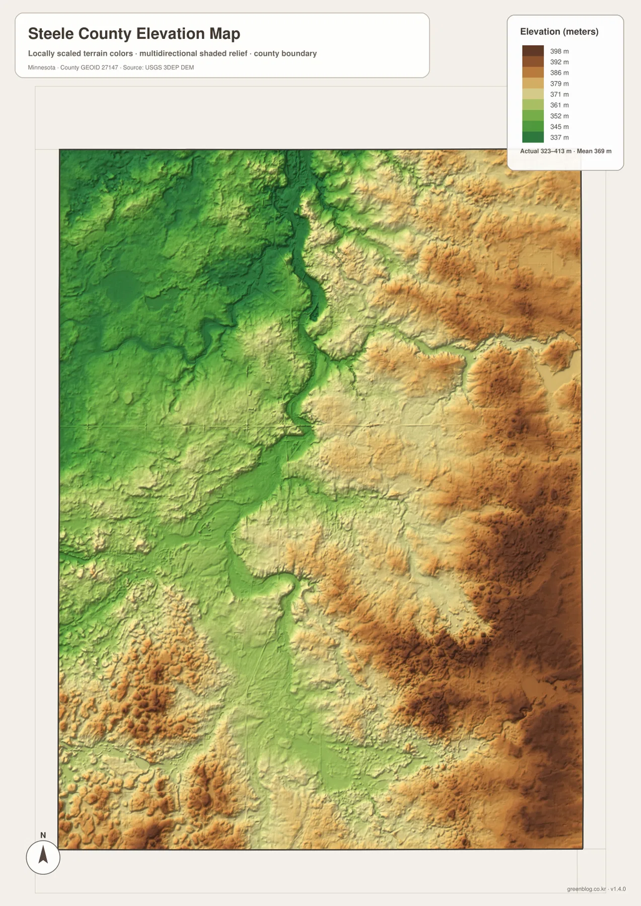
The western side is generally less elevated than the strongest eastern hills, although the southwest still contains a series of local rises. Ellendale therefore sits in a landscape that differs from both the low Straight River corridor and the higher eastern uplands. This is why a simple statement such as “east high, west low” is useful only as a first approximation. The shaded relief reveals many smaller valleys and hills inside that larger pattern, and those local differences become easier to recognize when the water map is kept nearby.
The elevation layer is generalized for county-scale comparison. It is not survey-grade information for construction, drainage design, parcel elevation, or legal boundary work. Anyone who needs exact elevations should use detailed USGS 3D Elevation Program data or professional survey information. For this page, the map is best used to compare the Straight River lowland with the eastern hills and to understand why creeks and towns occupy different parts of the county.
Frequently Asked Questions
How far are Medford, Ellendale, and Blooming Prairie from Owatonna?
The city map shows approximate straight-line distances of about 5 miles to Medford, 16 miles to Ellendale, and 18 miles to Blooming Prairie. Those lines are for geographic comparison rather than driving directions. Use the county map for I-35, U.S. 14, U.S. 218, MN 30, and other roads, then check a current navigation service when actual travel distance or time matters.
Where does the Straight River run through Steele County?
The Straight River follows the central part of the county and passes through the Owatonna–Medford area. Medford Creek, Crane Creek, Maple Creek, and Turtle Creek connect with nearby waterways, while the elevation map shows a lower corridor along the river. The water layer is a geographic reference and should not be used as a flood-depth or boating-safety map.
What elevation contrast is easiest to see?
The legend spans roughly 323 to 413 meters with a mean near 369 meters. The Straight River corridor is generally lower, while broader uplands rise to the east and southeast. Smaller hills also appear elsewhere, so the pattern is more varied than a simple east-high, west-low divide. Precise parcel or engineering elevations require detailed USGS data or professional survey information.The WebP images in the article are web-sized previews. The downloadable archive contains the original JPG versions used for the county, city, water, and elevation maps, each at 3638×2572 pixels. That larger size is useful when small road numbers, stream labels, or the shaded terrain need to be examined closely. It is also more suitable for printing than the compressed page previews, especially when the Owatonna road network or the branching creeks east of the Straight River need to remain legible.The maps are intended for general reference, education, presentations, and personal projects. They should not replace legal boundary records, live navigation, floodplain mapping, engineering surveys, or other specialized official products. A practical workflow is to use the county map for orientation, the city map for settlement spacing, the water map for the river and lake network, and the elevation map for terrain comparison. The ZIP keeps those four purposes together while preserving separate files for users who only need one type of information.
Map File Information
Download the map files associated with this page for reference, printing, and compatible visual projects.
- Included Files: Use only the versions confirmed in the article and supplied images
- File Type: Use the confirmed download contents
- Intended Use: Printing, education, presentations, and map-based projects
Related Maps
Sources and references
- Steele County official website — county administration and local background
- About Steele County — local natural features including Straight River and Rice Lake
- Steele County Parks and Recreation — Beaver Lake Park and Straight River Canoe Landing information
- U.S. Census Bureau TIGER/Line Shapefiles — county boundaries, roads, and place references
- USGS National Hydrography — river, creek, and lake reference data
- USGS 3D Elevation Program — elevation and terrain reference data
Green Map creates custom-edited map images using open geographic data sources such as geoBoundaries, Natural Earth, OpenStreetMap, and government open data. These maps are edited visual materials, not raw data files, and are provided for education, documents, presentations, and graphic reference.