St. Louis County stretches across a large part of northeastern Minnesota, linking the Duluth waterfront on Lake Superior with the Iron Range and an expansive northern landscape of lakes, rivers, forests, and sparse settlement. On the maps, the county’s long north-south shape is immediately noticeable: Duluth, Hermantown, and Rice Lake cluster in the southeast, while Hibbing, Chisholm, and Virginia form a separate urban belt much farther inland. This page provides four maps for boundaries and roads, major cities, water features, and elevation, and the same maps are available as high-resolution JPG files in the download box below.
The best way to understand the county is to compare those southern and central population centers with the huge northern interior. U.S. 53 provides a strong north-south reference from the Duluth area toward Virginia and Cook, while U.S. 169 ties together several Iron Range communities. North of those corridors, city labels become much less frequent but water features multiply. The elevation map adds another contrast, dropping toward Lake Superior while showing broad higher terrain across parts of the central and eastern interior. Together, those patterns make St. Louis County very different from a compact county organized around one city.
Table of Contents
A long county frame from Lake Superior to the northern border country
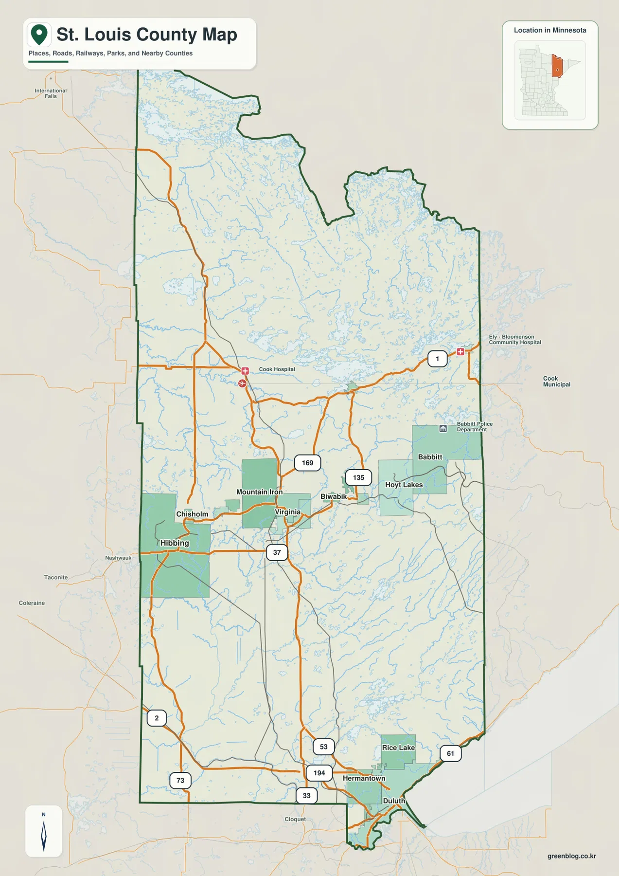
The county outline narrows around Duluth at the south end and expands into a much broader interior as it reaches north. The southeastern edge is shaped by Lake Superior rather than by a simple straight land boundary, while much of the western and eastern sides follow longer administrative lines. Itasca and Koochiching counties lie generally to the west, Lake County is to the east, and the far north reaches Minnesota’s international border country. That elongated geography explains why a portrait-oriented map works better here than the wider formats that suit many smaller counties.
U.S. 53 is the most useful road for organizing the map. It comes north from the Duluth area, passes through the Virginia corridor, and continues toward Cook and the northern interior. U.S. 169 is the second major reference in the Iron Range, running through the Hibbing-Virginia urban belt. MN 37 links Hibbing toward the U.S. 53 corridor, while MN 135 extends east from the Virginia area. U.S. 2 and MN 73 appear on the western side, and MN 194 and MN 33 help define the southern road pattern near Duluth and Hermantown. Readers do not need to memorize every route; locating U.S. 53 and U.S. 169 first makes the rest of the network much easier to place.
Duluth sits close to the southeastern tip of the county along Lake Superior, with Hermantown immediately inland and Rice Lake a short distance farther north. Moving into the central part of the county, Hibbing occupies the western side of the Iron Range urban area and Virginia sits farther east. Chisholm is close to Hibbing, Mountain Iron adjoins the Virginia side, and Biwabik, Hoyt Lakes, and Babbitt extend the string of communities eastward. The general map therefore shows two strong settlement zones separated by a substantial amount of rural territory rather than one continuous metropolitan corridor.
This general map is the best single reference when roads, city names, and the county outline all matter. It can show the broad direction from Duluth to Virginia, the close spacing of Hibbing and Chisholm, and the more easterly position of Babbitt without requiring a separate road atlas. It is not a live navigation map, however. Construction, winter conditions, closures, travel times, and turn-by-turn routing can change, so those decisions require a current transportation source. Here the map’s role is geographic orientation rather than real-time driving guidance.
Two separated city clusters: Duluth in the southeast and the Iron Range inland
The city map simplifies the county enough to reveal how unevenly the larger population centers are distributed. Its ranked city index places Duluth first, Hibbing second, Hermantown third, Virginia fourth, Chisholm fifth, and Rice Lake sixth. Those ranks reflect the dataset used to build this map and should be treated as a snapshot rather than a promise that the same order matches the newest official population estimate. Their main value here is visual: the six selected places show where the county’s largest urban concentrations sit relative to the enormous northern half.
Duluth, Hermantown, and Rice Lake form a tight southeastern cluster. Duluth follows the Lake Superior side of the county, Hermantown sits directly inland, and Rice Lake is just to the north. On the city map these places appear close enough to read as one broad urban area, even though each is a separate municipality. Returning to the general map adds the road context: U.S. 53 and other major routes funnel through this corner, helping explain why the southeastern tip contains such a strong concentration of city labels.
Hibbing, Chisholm, and Virginia form the second cluster, well north of the Duluth area. Hibbing and Chisholm are close together on the western side, while Virginia lies farther east, with Mountain Iron between them on the general map. The U.S. 169 corridor is the easiest way to follow this east-west Iron Range arrangement. Farther east, Biwabik, Hoyt Lakes, and Babbitt continue the settlement pattern even though they are not all included in the six-city ranking. This makes the Iron Range look less like a single city and more like a chain of distinct communities spread across higher inland terrain.
The vast northern half contains no comparable cluster on the simplified city map. That blank appearance does not mean the land is empty. It reflects the map’s decision to highlight only a small set of major cities, while northern St. Louis County contains smaller communities, forests, wetlands, lakes, and large areas of public and undeveloped land. For a presentation about population centers, the simplified city map is useful precisely because it removes distracting detail. For a geographic explanation of the north, however, the water and general maps provide much more information.
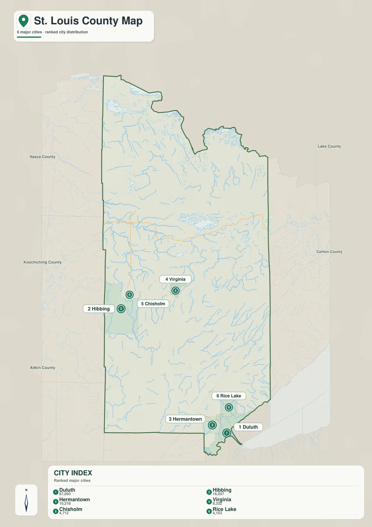
When the question is simply where the major cities are, this reduced map is easier to read than the detailed road map. When the question is how those places are connected, the general map should be used beside it. Duluth to Virginia is best understood through U.S. 53, while Hibbing to Virginia is better framed by U.S. 169 and the Iron Range road network. Switching between the two prevents city symbols from being mistaken for travel routes and keeps the explanation focused on the type of information each map actually contains.
A dense northern water network flowing toward several major river systems
The terrain-and-water map changes the character of the county completely. Northern St. Louis County is packed with small lakes, bays, streams, and branching waterways. Around Lake Vermilion, the map labels Black Bay, Kohler Bay, Saunders Bay, Wolf Bay, and Pike Bay, giving the northern lake country a very different visual texture from the road-focused view. Water features are so numerous in this area that they become the clearest way to understand local geography where major highways and large cities are relatively sparse.
Several named rivers organize the central and northern drainage pattern. The Vermilion River stands out in the upper interior. Farther west, the Little Fork River and Sturgeon River form major channels, with the Rice River running across the same broad region. The Pike River and Embarrass River are prominent farther east and southeast. Rather than all flowing in one simple direction, these rivers occupy different valleys and connect to different larger systems, which is why the county’s water map looks like a network of separate basins rather than one trunk river with short tributaries.
The southern part of the county is organized around the St. Louis River. Its broad course leads toward the Duluth area and the western end of Lake Superior, where an inland river system meets one of the world’s largest freshwater lakes. That southeastern water setting is very different from the northern lake country. In the north, water is dispersed among many lakes, bays, wetlands, and streams; near Duluth, the St. Louis River and Lake Superior dominate the regional picture. Few county maps show both an enormous Great Lakes shoreline and such a dense interior lake network within the same boundary.
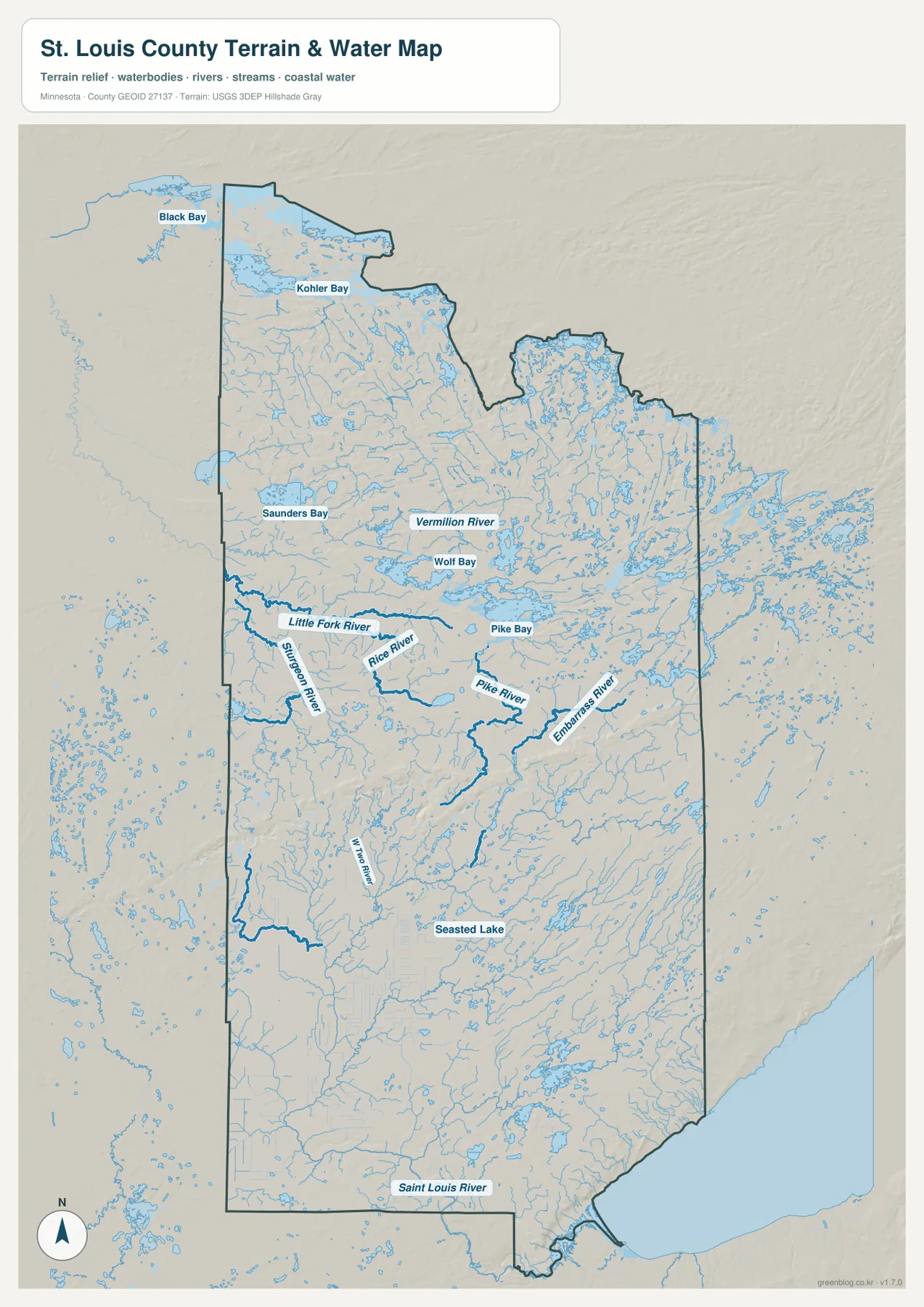
This map is designed for geographic reference, not for boating, flood, parcel, or access decisions. It does not show current water levels, channel depth, navigation hazards, private-property access, or regulatory boundaries. Anyone planning a trip on Lake Vermilion, Lake Superior, or a river should use current information from the appropriate agency. For map reading, the useful lesson is the relationship among water, settlement, and terrain: Duluth sits beside the St. Louis River and Lake Superior, the Iron Range lies among many interior drainage routes, and the northern county is defined by exceptionally dense surface water.
From 183 to 587 meters: low Lake Superior shore and higher inland ridges
The elevation map gives an actual county range of about 183 to 587 meters and a mean near 419 meters. The lowest terrain is associated with Lake Superior and the Duluth shoreline at the southeastern edge. Moving inland, the colors change quickly and much higher ground appears across parts of the central and eastern county. The north is not uniformly high; broad green areas occur around the lake-rich northern interior, while ridges and rougher terrain create a more complex band through the middle of the county.
One of the strongest elevation patterns crosses the Iron Range area. Higher brown terrain appears near and east of the Hibbing-Virginia belt, continuing through parts of the central and eastern interior. The generalized surface does not define mine pits, individual ridgelines, or engineered slopes with survey precision, but it makes the regional rise easy to see. Comparing this map with the road map also shows that the U.S. 169 communities sit close to a major change in relief rather than on a flat plain extending all the way to Duluth.
The Duluth end of the county provides the sharpest contrast. Lake Superior establishes a low base level, while the land immediately inland climbs into much higher terrain over a relatively short horizontal distance. That helps explain why the southeastern corner looks compressed on the elevation map: low green shoreline areas sit close to tan and brown uplands. Northern St. Louis County shows a different pattern, with larger expanses of lower green terrain broken by smaller ridges and drainage corridors around the lakes and wetlands.
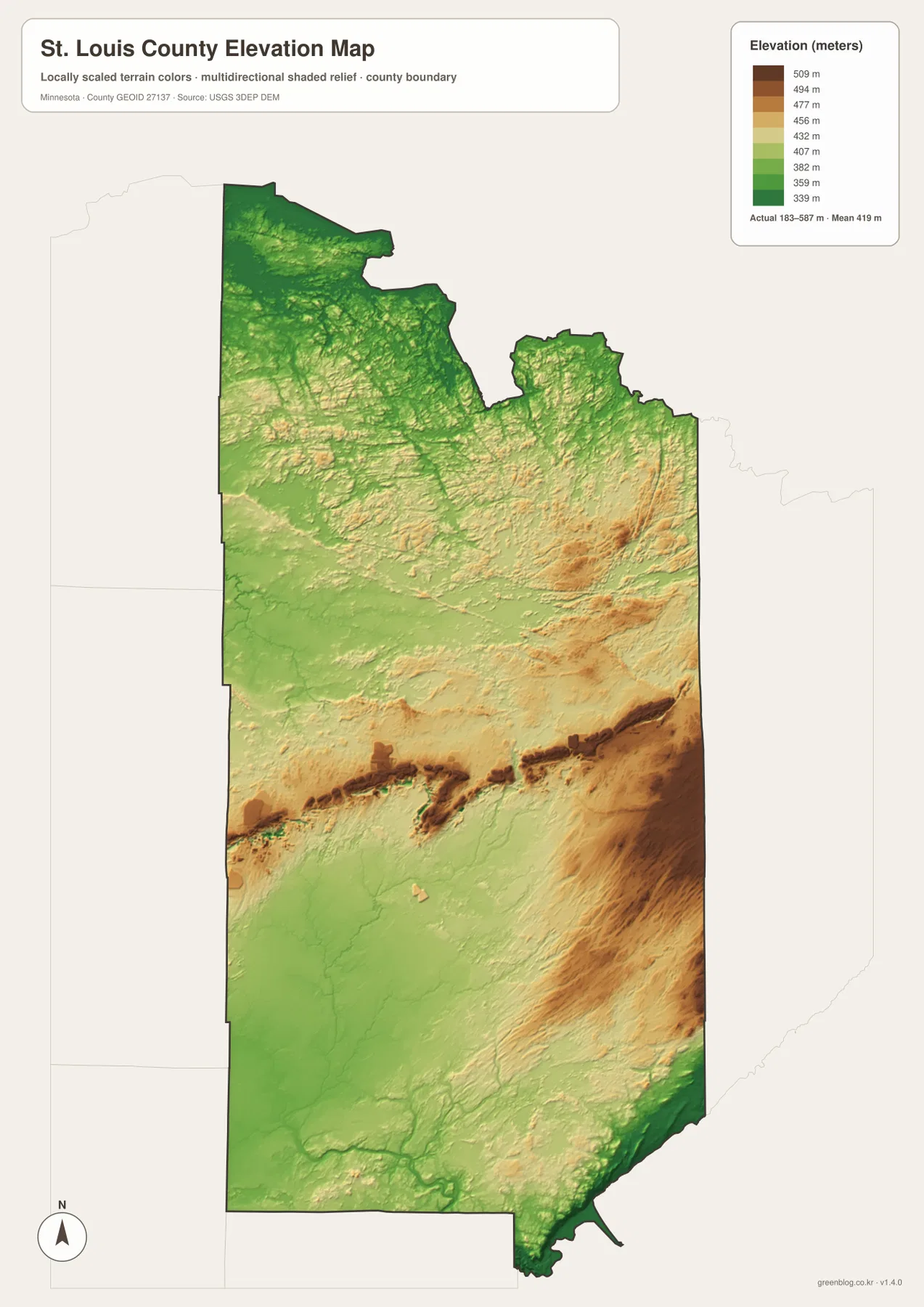
The colored relief is generalized for county-scale comparison. It is appropriate for explaining where the landscape is broadly higher or lower, but it should not be treated as a site survey for a building, road, drainage project, slope assessment, or engineering design. Exact elevations require authoritative numerical elevation data or field surveying. For ordinary readers, the main value is seeing why Duluth’s shoreline setting, the Iron Range interior, and the northern lake country feel like three distinct terrain zones even though they belong to the same county.
Which St. Louis County map fits the question?
Start with the general county map when you need the whole framework. It is the best choice for locating Duluth, following U.S. 53 toward Virginia, tracing U.S. 169 through the Iron Range, or comparing Babbitt and Hoyt Lakes with the western communities. Because roads, city names, water, and the boundary appear together, this version works well for regional orientation, classroom explanations, travel planning at a broad scale, and reports that need one all-purpose reference map.
Choose the city map when the distribution of population centers matters more than roads. Its clearest message is the separation between the Duluth-Hermantown-Rice Lake cluster and the Hibbing-Chisholm-Virginia cluster. Choose the water map for Lake Vermilion, the Vermilion River, Little Fork River, Pike River, St. Louis River, and the Lake Superior connection. Choose the elevation map when the subject is relief, especially the low lakeshore near Duluth and the higher central and eastern terrain.
A good report does not need all four maps unless comparing map themes is part of the subject. A page about Iron Range communities may only need the general and city maps. A page about rivers and northern lake country can pair the general map with the water map. A lesson about Lake Superior and inland relief can use the general and elevation maps side by side. Selecting the map that answers the actual question keeps the page readable and avoids burying the county’s strongest geographic patterns under unnecessary detail.
St. Louis County’s official overview describes a county of roughly 7,000 square miles and identifies it as the largest county east of the Mississippi River. The maps make that scale tangible: Duluth, the Iron Range, large inland lake systems, and the northern border country occupy one administrative unit. The county’s Enterprise GIS also provides more detailed geospatial resources for readers who need parcel, administrative, or specialized local information beyond the general-purpose maps presented here.
The WebP images embedded in the article are optimized previews. The downloadable ZIP contains four high-resolution JPG originals, one for each map, at 2572×3638 pixels. Those files are better for printing, enlarging small labels, classroom handouts, and presentation slides. They remain general geographic reference maps, however, and should not replace legal boundary records, parcel data, current navigation, flood determinations, boating charts, or engineering-grade elevation measurements.
Frequently Asked Questions
Which map best shows the relationship between Duluth and the Hibbing-Virginia Iron Range cities?
Use the general county map when roads matter. Duluth is at the southeastern end near Lake Superior, while Hibbing and Virginia are much farther inland. U.S. 53 provides the clearest Duluth-to-Virginia reference, and U.S. 169 helps organize the Hibbing-Virginia city chain. The simplified city map is a useful companion when you want the relative positions without the road detail.
Why does northern St. Louis County look so complex on the water map?
The north contains a very dense mix of lakes, bays, wetlands, streams, and larger rivers. Lake Vermilion and its labeled bays occupy part of that landscape, while the Vermilion, Little Fork, Sturgeon, Rice, and Pike rivers follow different drainage routes. The map is meant to show geographic relationships, not current water levels, flood zones, channel depths, navigation hazards, or access rights.
What does the elevation map show between Lake Superior and the Iron Range?
The county-wide elevation range is about 183 to 587 meters. The lowest terrain occurs near Lake Superior, and the land rises sharply inland from the Duluth area. Higher terrain appears across parts of the central and eastern interior, including near the Iron Range, while the northern lake country contains broader lower areas. The map is suitable for regional comparison but not for exact site elevations or engineering work.
Map File Information
The ZIP contains the high-resolution JPG originals for the St. Louis County general map, city map, terrain-and-water map, and elevation map used on this page.
- Included Files: 4 high-resolution JPG maps
Related Maps
Sources and references
- St. Louis County official overview — county scale, natural resources, and regional context
- St. Louis County Enterprise GIS — local geospatial data resources
- U.S. Census Bureau TIGER/Line Shapefiles — boundaries, roads, and place reference
- USGS National Hydrography — rivers, streams, and lake reference
- USGS 3D Elevation Program — elevation and terrain reference
Green Map creates custom-edited map images using open geographic data sources such as geoBoundaries, Natural Earth, OpenStreetMap, and government open data. These maps are edited visual materials, not raw data files, and are provided for education, documents, presentations, and graphic reference.