Rice County lies in southern Minnesota, where Faribault and Northfield anchor two of the county’s largest urban areas while smaller communities such as Lonsdale, Dundas, Morristown, and Nerstrand occupy very different corners of the map. Interstate 35 crosses the county from south to north, the Cannon and Straight rivers meet in the central valley, a cluster of lakes spreads across the western half, and higher ground becomes especially prominent in the southeast. This page separates those features into boundary, city, water, and elevation views. High-resolution JPG copies of the same four maps can be downloaded from the file box later on the page. High-resolution map files are available for download in the section below.
The county’s outline is distinctive enough to recognize without labels. A northwestern extension reaches toward Lonsdale, while the broader eastern and southern body contains Northfield, Faribault, Nerstrand, and Morristown. Faribault sits slightly south of the county’s center, Northfield lies in the northeast, and Dundas is tucked close to Northfield along the Cannon River corridor. The western half contains numerous lakes and rolling terrain, while the elevation map shows a much stronger rise in the southeast. Reading the maps together makes the relationship among settlement, transportation, water, and relief much clearer than any single layer can do on its own.
Table of Contents
Faribault, Northfield, and the roads that organize Rice County
The general county map is the best starting point for orientation. Faribault appears as a large built-up area in the south-central part of the county, with several routes meeting around it. Interstate 35 runs north-south through the county, passing west of Northfield and east of Lonsdale before leaving the county to the north. Route 19 crosses the northern part near Northfield and Lonsdale, while Routes 21 and 3 are visible around Faribault. Route 246 serves the eastern side toward Nerstrand, Route 60 leaves the county to the southeast, Route 99 crosses the west-central side, and Route 13 reaches the southwestern edge.
Northfield and Faribault have noticeably different map settings. Faribault is surrounded by a wider web of roads and occupies a central position relative to the southern half of the county. Northfield sits nearer the northeastern boundary and is closely paired with Dundas, which lies just to its southwest. Lonsdale is separated from those cities in the northwestern extension, while Morristown occupies the southwest and Nerstrand lies near the eastern edge. This dispersed pattern is useful to keep in mind when planning county travel because a destination described simply as “in Rice County” may be a substantial distance from either of the two largest cities.
Neighboring counties provide another layer of orientation. Dakota and Scott counties lie to the north, Le Sueur and Steele counties are to the west, and Goodhue and Dodge counties are to the east. The road connections shown on the map help explain how Rice County links areas south of the Twin Cities with communities farther across southern Minnesota. The map is intended for geographic reference rather than live navigation, so road construction, closures, and turn-by-turn routing should still be checked with current transportation information.
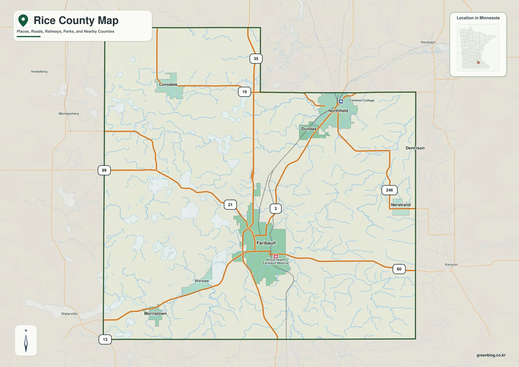
A few recognizable landmarks are included as reference points. Carleton College is marked at Northfield, and Allina Health Faribault Medical Center appears near Faribault. These labels are not meant to form a complete directory of institutions. Instead, they help locate the cores of the two largest urban areas within the county. When those landmarks are viewed alongside the highway network and municipal outlines, the contrast between Northfield’s northeastern setting and Faribault’s more central southern position becomes easy to follow.
Six ranked cities reveal two major centers and four smaller communities
The city map strips away much of the background detail and ranks six major communities. Its index lists Faribault at 24,631, Northfield at 20,742, Lonsdale at 4,896, Dundas at 1,916, Morristown at 1,265, and Nerstrand at 215. These are the values printed on the supplied map and are useful for understanding the map’s ranking. They should not automatically be treated as the newest population estimates; anyone needing current demographic figures should check the latest U.S. Census Bureau data.
The distribution is more informative than the ranking alone. Faribault and Northfield clearly form the two largest centers, but they are not adjacent. Faribault is in the south-central area, while Northfield is well to the northeast. Dundas lies close to Northfield and therefore appears as part of the same local cluster at county scale. Lonsdale is isolated in the northwestern extension, Morristown sits in the southwest, and Nerstrand is close to the eastern boundary. Rice County therefore does not have one single chain of towns; its main communities form several separate nodes connected by highways and rural roads.
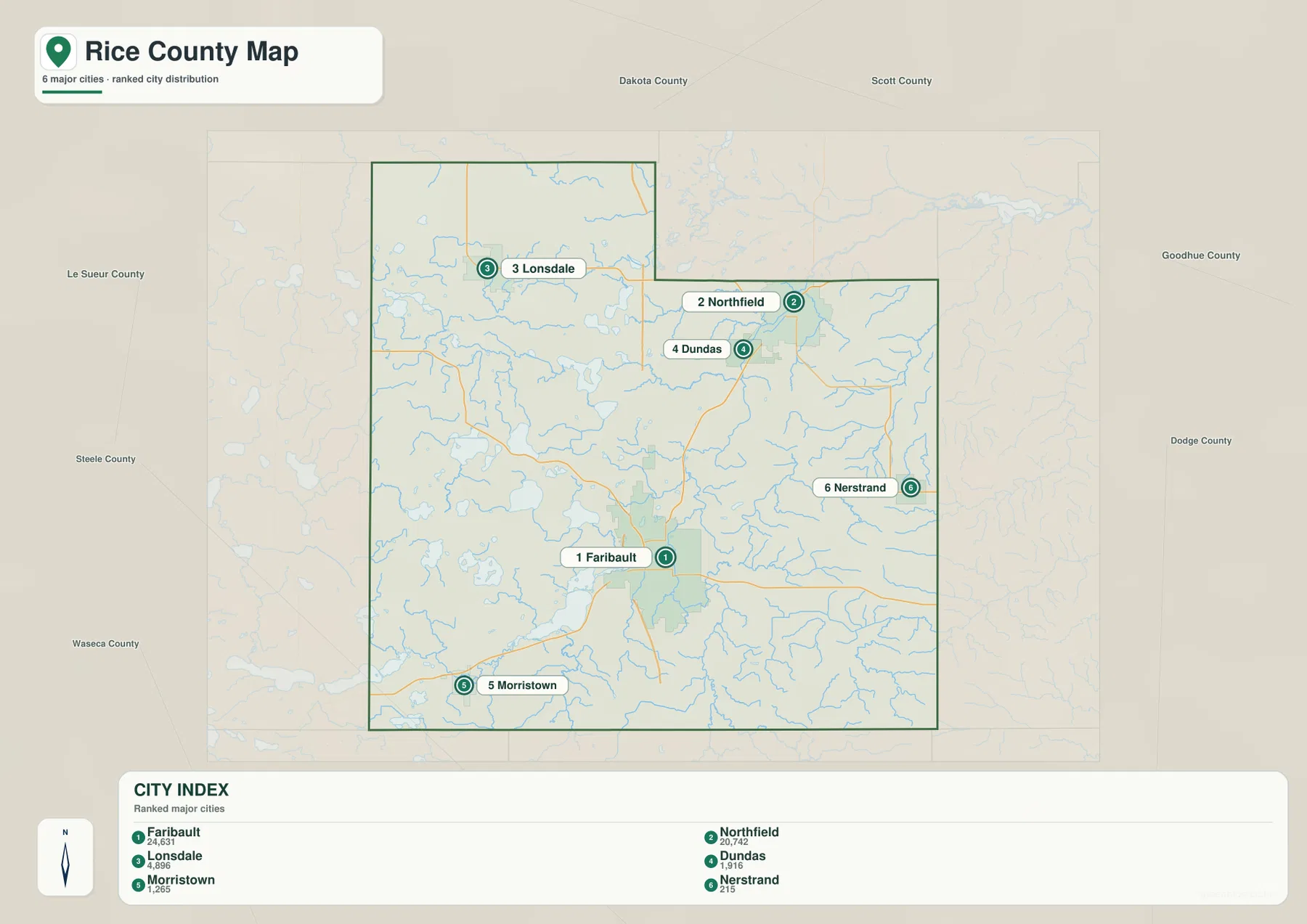
The surrounding county labels on this view make cross-county direction easier to understand. Northfield is closest to the Dakota and Goodhue county sides, Lonsdale is nearer the Scott and Le Sueur county directions, and Morristown is closer to the Steele and Waseca sides. These relationships matter when the purpose of the map is to find a convenient regional reference point rather than to study municipal boundaries. The city map is especially useful for quickly answering questions such as whether a place lies closer to Faribault, Northfield, or one of the county edges.
Cannon River, Straight River, and a lake-rich western half
The terrain-and-water map puts the Cannon River at the center of the county’s drainage picture. The Straight River comes north through the south-central part of Rice County toward Faribault, while the Cannon River continues through the central valley and then bends north and northeast toward the Northfield area. Prairie Creek enters from the east, and Heath Creek and Wolf Creek are labeled farther north and west. The network of smaller tributaries shows that the named rivers are only the main framework of a much denser local drainage system.
The western half of the county has a different visual character because numerous lakes break up the land surface. Circle Lake, Mazaska Lake, Shields Lake, French Lake, Cedar Lake, and Cannon Lake are all labeled. Shields Lake and Mazaska Lake form useful reference points in the west-central lake district, while Cannon Lake is a larger water body southwest of Faribault. Rice County’s official park information also connects the map to real recreation sites: McCullough Park is on Shields Lake, and Shager Park provides access at Cannon Lake. These examples help show that the water map is not just an abstract stream network; several of the labeled lakes are prominent local destinations.
The southeastern corner introduces another drainage direction. The North Branch Zumbro River is labeled near the lower eastern side of the map, showing that not every stream in Rice County feeds the Cannon River system. This separation matters when interpreting the terrain. The county contains a western lake district, a central Cannon–Straight river corridor, and southeastern drainage that leads toward another basin. The map is a reference for geographic relationships only; it is not a flood-hazard map, a water-quality map, a parcel boundary product, or a navigation chart.
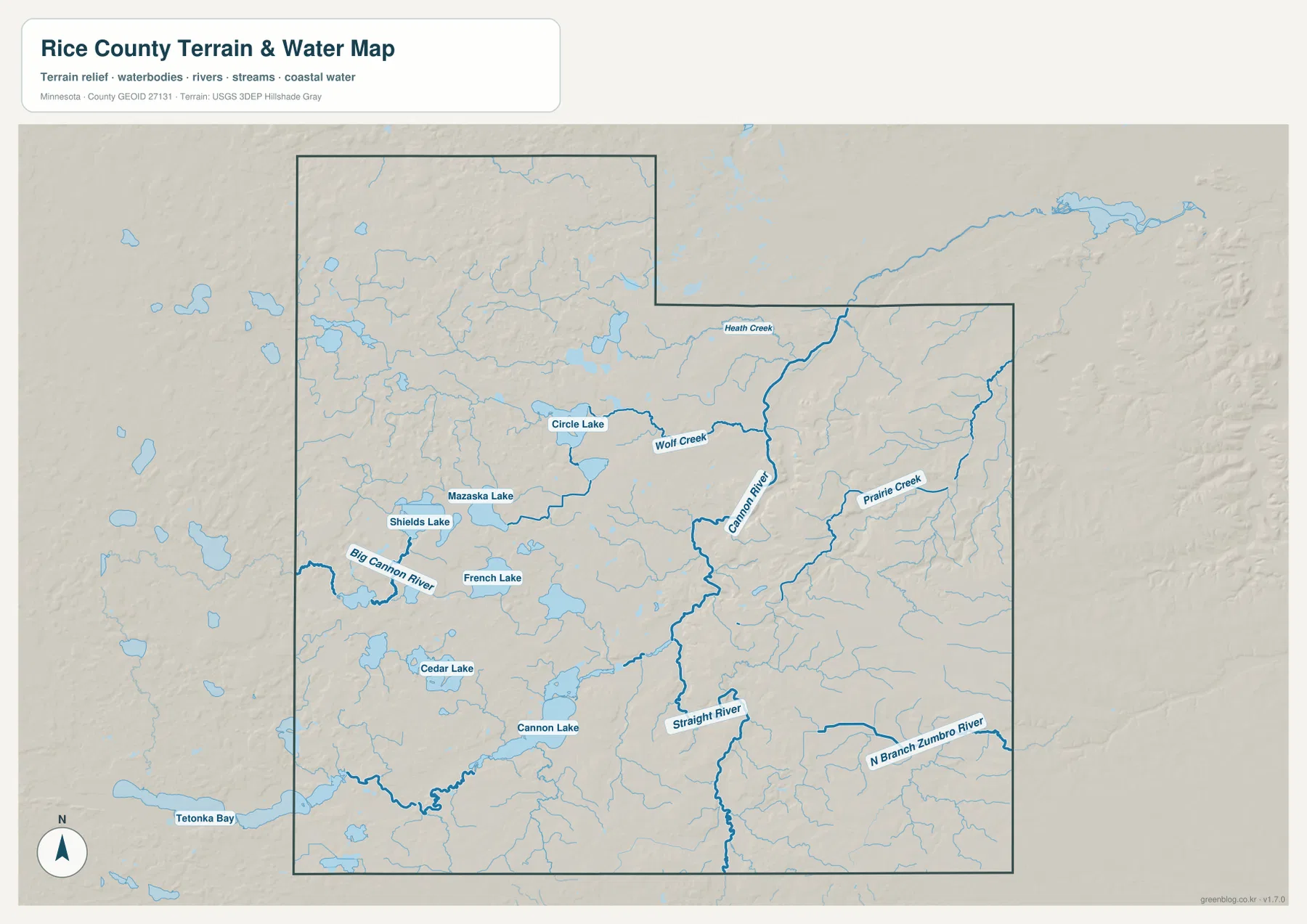
Comparing this layer with the city map reveals a close relationship between the river corridor and three communities. Faribault lies where the major central waterways converge, while Dundas and Northfield continue north along the Cannon River valley. Lonsdale is farther west of the main river, and Nerstrand lies among smaller eastern tributaries. Settlement does not follow water perfectly, but the alignment of Faribault, Dundas, and Northfield along the Cannon corridor is one of the clearest geographic patterns visible in the county.
Low river corridors contrast with the high southeast
The elevation map makes the county’s topographic contrast much more obvious. Its legend gives an actual elevation range of about 270 to 388 meters, with a mean near 330 meters. The Cannon River corridor appears as a lower green band running through the central and northeastern parts of the county. The Straight River valley also forms a lower route north from the southern part of the county. Those green corridors line up well with the major waterways shown on the previous map, giving a visual explanation for why the rivers occupy those paths.
The southeast is strikingly different. Broad areas of tan and brown mark higher ground, and closely spaced ridges and small valleys produce a more rugged appearance. Higher terrain also extends toward the Nerstrand side of the county. Western Rice County is not flat; the shaded relief shows many small hills and depressions around the lake district. Still, the west has a more mixed surface, while the southeast contains the most extensive block of high relief on the supplied map.
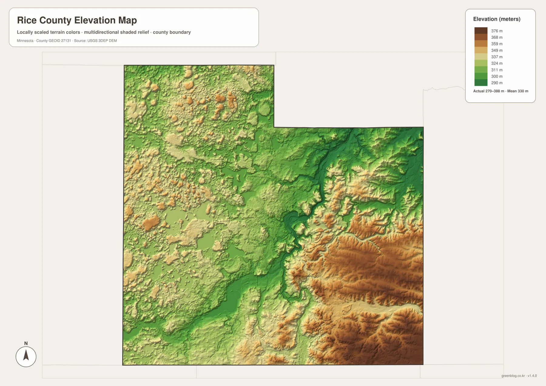
This relief helps make sense of the drainage network. Small streams descend from higher ground toward lower valleys, while the Cannon and Straight rivers occupy some of the broadest low areas. The map is deliberately generalized to show county-scale patterns. It should not be used as a substitute for survey data, engineering-grade elevation measurements, slope analysis for construction, or property-level site assessment. For those purposes, a more precise dataset and professional review would be required.
Choosing the most useful Rice County map for a specific task
For basic orientation, the general county map is usually the most useful first choice. It combines municipal areas, roads, nearby places, streams, and the county outline, making it suitable for locating Faribault, Northfield, Lonsdale, or the route toward Nerstrand and Morristown. The ranked city map is better when the goal is simply to compare the positions of the six highlighted communities without the distraction of smaller road and water labels.
The water map becomes more valuable when the question involves rivers, lakes, or the physical setting of a place. It distinguishes the Cannon River from the Straight River, shows western lakes such as Shields, Mazaska, Circle, and Cannon, and identifies tributaries including Prairie, Heath, and Wolf creeks. Pairing it with the elevation map explains why the central river corridor appears lower than the southeastern uplands. That combination is helpful for educational work, regional orientation, and anyone who wants to understand the landscape rather than only find a road.
For printed material, the original JPG files provide more detail than the WebP previews embedded in the article. The download archive contains the same four map subjects shown here—general county, city, water, and elevation—and each original image is 3638 by 2572 pixels. Reviewing the web versions first makes it easy to choose the relevant map, then the larger file can be scaled for a handout, slide, worksheet, or personal reference while keeping labels and linework clearer.
Frequently Asked Questions
Which map is best for comparing Faribault and Northfield?
The general county map is the best choice when you need both city locations and major roads. Faribault is south of the county center, Northfield is in the northeast, and Dundas sits close to Northfield between the two major urban areas. Interstate 35 and several numbered routes provide additional context. The ranked city map is useful as a second view when you only want the relative positions of the six highlighted communities.
Where do the Cannon River and Straight River appear in Rice County?
The Straight River enters the south-central part of the county and runs toward Faribault. The Cannon River follows the central valley and continues north toward Dundas and Northfield. On the water map, the two major waterways come together in the Faribault area before the Cannon River continues northeast. The elevation map shows the same corridor as relatively low ground compared with the high terrain farther southeast.
What is the clearest feature on the Rice County elevation map?
The strongest contrast is between the low central river valleys and the higher southeastern uplands. The supplied legend shows elevations from roughly 270 to 388 meters, with an average near 330 meters. Green tones follow much of the Cannon and Straight river corridor, while tan and brown areas cover broad parts of the southeast. The layer is intended for county-scale comparison and should not be treated as a property survey or engineering elevation source.
Map File Information
The ZIP includes the original JPG versions of the Rice County general, city, water, and elevation maps shown on this page.
- Included Files: Use only the versions confirmed in the article and supplied images
- File Type: Use the confirmed download contents
- Intended Use: Printing, education, presentations, and map-based projects
Related Maps
Sources and references
County-specific background is available from the official Rice County history page, while information about Shields Lake, Cannon Lake, and local natural areas can be found through Rice County Parks. Boundary reference data are available from the U.S. Census Bureau TIGER/Line program, hydrography information from USGS National Hydrography, and elevation data from the USGS 3D Elevation Program.
Green Map creates custom-edited map images using open geographic data sources such as geoBoundaries, Natural Earth, OpenStreetMap, and government open data. These maps are edited visual materials, not raw data files, and are provided for education, documents, presentations, and graphic reference.