McLeod County lies in south-central Minnesota, with Hutchinson and Glencoe providing two easy reference points for understanding the county. This guide brings the boundary, major roads, highlighted cities, waterways, lakes, and elevation into one page so the different maps can be compared without losing geographic context. The WebP maps on the page are designed for quick viewing, while the matching high-resolution JPG originals are available together in a ZIP for printing or personal reference. High-resolution map files are available for download in the section below.
The simplest way to get oriented is to locate Hutchinson in the northwest part of the county and Glencoe farther southeast. Winsted and Silver Lake sit to the north, Lester Prairie is near the eastern side, and Stewart is near the southwest edge. Once those places are familiar, the South Fork Crow River and the higher northwest terrain make much more sense because they can be related back to recognizable towns and roads.
Table of Contents
Using Hutchinson and Glencoe to Orient the County
The county overview map combines the McLeod County boundary with towns, major roads, rail lines, parks, and nearby places. The outline is not a simple rectangle: a large inset on the southeast side gives the county a distinctive shape that is easy to recognize on the other maps. Learning that outline first is useful because the water and elevation maps contain fewer town labels and rely more heavily on the county boundary for orientation.
Around Hutchinson, roads labeled 22 and 4 create a clear local reference. Route 7 continues east through the Silver Lake area, while US 212 forms a strong east–west line through the southern part of the county and passes near Glencoe, Brownton, and Stewart. Route 15 provides a useful north–south guide in the western half, and roads labeled 1 and 261 appear around the Glencoe and Lester Prairie side of the map.
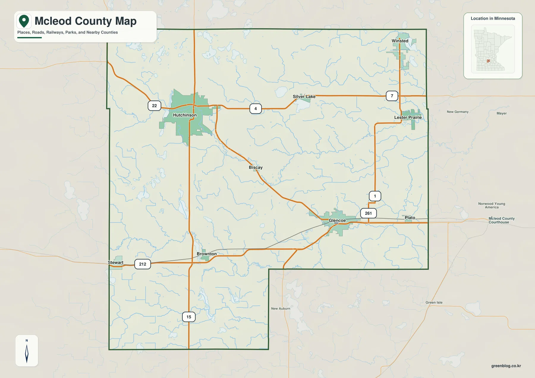
Several places outside the county boundary are shown as additional reference points. New Germany and Mayer appear to the east, while New Auburn and Green Isle are south of the county. These labels make it easier to see how McLeod County connects with surrounding communities, especially where a road leaves the county soon after passing one of the eastern or southern towns.
The overview should be treated as a general location map rather than a legal land map. The boundary is appropriate for understanding the county as a whole, but parcel lines, survey monuments, zoning, and property ownership require official county records. McLeod County maintains its own GIS viewer for those more detailed questions, so the public map here is best used as the first level of geographic reference.
How the Six Highlighted Cities Are Distributed
The city distribution map highlights Hutchinson, Glencoe, Winsted, Lester Prairie, Silver Lake, and Stewart. Hutchinson occupies the northwest side and Glencoe sits farther southeast, which makes the two largest visual centers useful anchors for the rest of the county. Winsted and Lester Prairie are concentrated in the northeast, Silver Lake is farther west along the northern half, and Stewart stands apart near the southwest corner.
That arrangement matters because the major communities do not form one compact cluster. A reader moving from Stewart to Winsted, for example, crosses a large portion of the county, while Silver Lake and Hutchinson are much closer together on the map. The city view makes those relative relationships clear without requiring the reader to sort through every smaller road or water label.
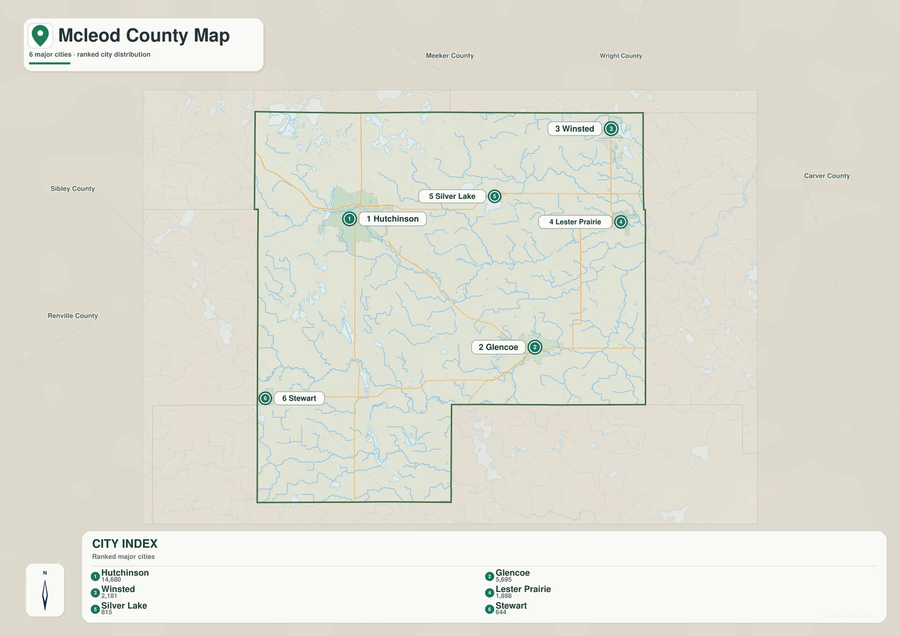
The surrounding county labels also add context. Meeker County and Wright County are shown along the north, Carver County to the east, and Sibley County plus Renville County on the west side. Those labels help explain why Winsted and Lester Prairie feel close to the outer edge of McLeod County, while the other highlighted places sit deeper within the county outline.
This city map is a simplified comparison rather than a complete municipal directory. The broader county map also labels places such as Biscay and Brownton, which are not among the six emphasized locations here. When the goal is to understand every named settlement or a specific local road, the city map should therefore be used together with the full county overview.
Following the South Fork Crow River and the County Lakes
The water map shifts attention away from roads and toward the drainage network. The South Fork Crow River is the dominant feature, entering from the western side, bending through the center of the county, and continuing east. Its broad path is easy to recognize because several smaller streams and channels feed into it, creating a connected water pattern across the middle of McLeod County.
Cedar Lake is labeled in the northwest, with Otter Lake positioned farther south near the South Fork Crow River. Silver Lake appears in the northern half, while Eagle Lake and Lake Marion are shown in the southwest. Bakers Lake lies farther south, and Baylor Lake appears beyond the eastern county boundary. These labels demonstrate that lakes are scattered through several parts of the county rather than confined to a single lake district.
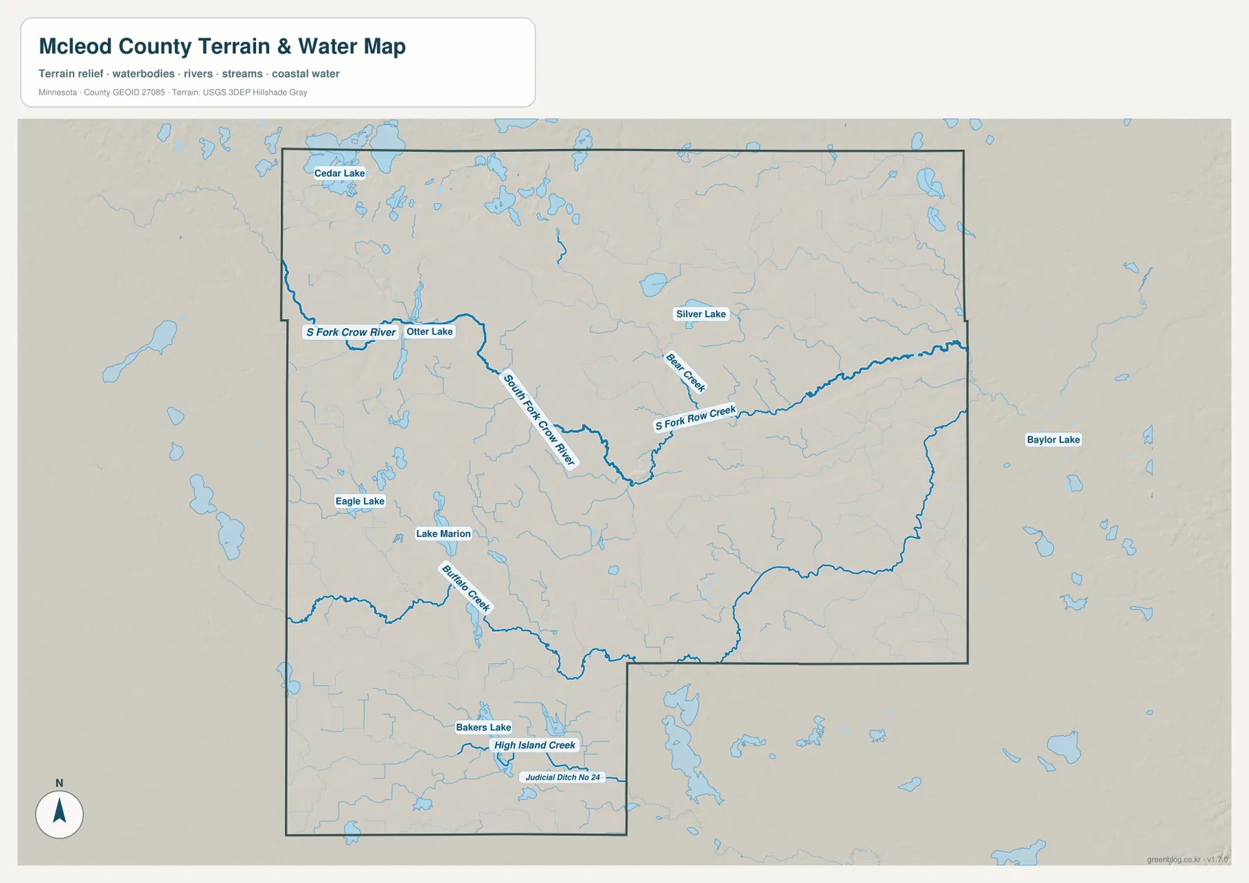
Bear Creek, Buffalo Creek, and High Island Creek are among the smaller waterways labeled on the map. Judicial Ditch No. 24 also appears in the south, a useful reminder that not every blue line represents the same kind of natural stream. Reading the names together helps distinguish the main river from smaller creeks, lakes, and managed drainage features.
This map is intended to show water locations and surrounding terrain, not to define flood zones, navigable waters, water depth, parcel boundaries, or legal access. A lake or creek label does not tell you where public entry is available. For fishing, boating, flood planning, or recreation, current Minnesota DNR and local agency information should be checked before making decisions.
Elevation Falls from the Northwest toward the Southeast
The elevation map shows a clear county-scale contrast. Its legend gives an actual elevation range of about 291 to 349 meters, with a mean near 317 meters. Browns and oranges dominate much of the northwest, indicating higher ground, while greens become more common toward the east and southeast where the landscape is generally lower.
A darker green corridor follows much of the South Fork Crow River through the center and toward the east. The overlap is especially useful when the elevation and water maps are viewed together because the river can be connected with the lower terrain around it. The northwest is not uniformly high, however; small valleys and depressions cut through the higher surface, while the south also contains modest local rises and low areas.
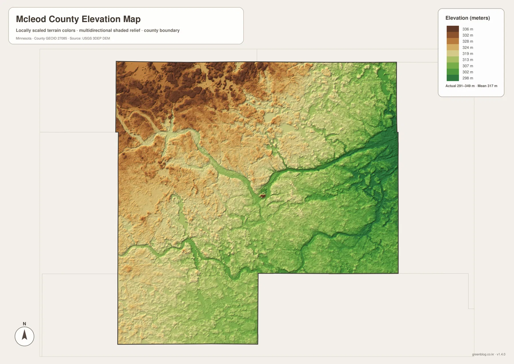
The color scale is local to McLeod County and is designed to make differences within the county visible. A brown or green shade on another county map should not be assumed to represent exactly the same elevation. The numeric legend is the correct reference for absolute height, while the colors are most useful for seeing the county’s relative pattern at a glance.
The surface is a generalized representation based on elevation data, not a survey-grade product. Construction, drainage design, road engineering, and legal elevation questions require more precise site measurements. The map is most useful for understanding broad relief, identifying higher and lower parts of the county, and comparing those areas with the river and lake network.
Connecting Roads, Towns, and Waterways
McLeod County becomes easier to remember when roads and waterways are used together. Start with Hutchinson and Glencoe, then add Silver Lake and Winsted to the north, Lester Prairie to the east, and Stewart to the southwest. The South Fork Crow River curves between many of these reference areas, creating a natural line that helps separate the higher northwest from the lower central and eastern terrain.
US 212 is particularly useful for reading the southern half of the county because it runs east–west past Glencoe and toward Stewart and Brownton. Route 7 gives a similar east–west reference farther north, while the roads around Hutchinson and Glencoe show that the two cities connect to different parts of the county network. These are geographic reference points, not a substitute for current navigation or road-condition information.
The same method works in reverse. If you begin with Cedar Lake or Silver Lake on the water map, the county overview helps connect those features to nearby towns and roads. If you begin with the elevation map, the river corridor provides a recognizable low feature that can be traced back to the water map. Moving between the maps turns separate layers of information into a more complete picture of the county.
Choosing the Best Map for Your Purpose
Use the county overview when boundaries, roads, towns, and nearby places matter most. The city distribution map is better for a quick comparison of Hutchinson, Glencoe, Winsted, Lester Prairie, Silver Lake, and Stewart. The water map is the clearest choice when the South Fork Crow River, lakes, or tributaries are the main subject, while the elevation map is best for explaining the higher northwest and lower southeast.
For school assignments, local history notes, or regional presentations, the maps can also be paired. The city and water maps make it easier to discuss where communities sit relative to the river system, and the water and elevation maps show how lower terrain corresponds with major drainage features. Because each map emphasizes a different topic, reading the title and legend before comparing them prevents one layer from being mistaken for another.
The WebP images on the page are optimized for fast browser viewing. The download ZIP contains the corresponding high-resolution JPG originals, each measuring 3638 by 2572 pixels. When small road numbers or water labels are difficult to read on screen, opening the JPG and zooming into the original usually provides a much cleaner result than saving a browser screenshot.
Details Worth Checking When Reading the Maps
The southeast indentation in the county boundary is one of the easiest features to miss on a small display. Locating Glencoe and US 212 first makes that part of the outline easier to follow, and the same shape reappears on the city, water, and elevation maps. Using the boundary as a fixed frame is especially helpful when a thematic map removes most road and town labels.
Hutchinson has a broad urban footprint on the overview, but that visual size should not be treated as a precise statement about municipal area or current population. The city distribution view highlights only six communities, and it is not meant to replace a complete list of municipalities or townships. Official boundary, parcel, and land information is available from McLeod County’s GIS resources when that level of detail is needed.
Water features require similar care. The South Fork Crow River and named lakes are useful geographic landmarks, but a mapped shoreline does not establish public access, recreation rules, or flood safety. This page works best as a geographic starting point: identify the place, understand how it relates to roads and terrain, and then consult the responsible local or state agency for current site-specific information.
Frequently Asked Questions
Which map makes Hutchinson and Glencoe easiest to place?
The county overview is the best starting point because it shows both cities with the main roads and surrounding places. Hutchinson is in the northwest part of the county, while Glencoe is farther southeast. The city distribution view is useful when you want a cleaner comparison among the six highlighted communities.
How does the South Fork Crow River cross McLeod County?
On the water map, the South Fork Crow River enters from the west, bends across the central part of the county, and continues east. Otter Lake and several smaller tributaries appear near the river system. Flood risk, public access, water depth, and recreation conditions are not shown and should be checked with current official sources.
What is the main elevation contrast across the county?
The broad pattern is higher terrain in the northwest and lower ground toward the east and southeast. The legend shows an actual range of about 291 to 349 meters and a mean near 317 meters. This is a regional comparison map, not a substitute for survey-grade or engineering elevation measurements.
Map File Information
The ZIP contains the original high-resolution JPG versions of the McLeod County overview, city distribution, water, and elevation maps.
- File Type: ZIP containing 4 JPG files
Related Maps
Sources and References
- McLeod County official website – county government, maps, and local information
- McLeod County GIS Viewer – official county GIS and land information
- U.S. Census Bureau TIGER/Line Shapefiles – county boundary and geographic reference data
- USGS National Hydrography – river, stream, and lake reference data
- USGS 3D Elevation Program – elevation and terrain reference data
Green Map creates custom-edited map images using open geographic data sources such as geoBoundaries, Natural Earth, OpenStreetMap, and government open data. These maps are edited visual materials, not raw data files, and are provided for education, documents, presentations, and graphic reference.