Lincoln County sits along Minnesota’s western edge, where a small group of towns is spread across an agricultural landscape cut by rivers, creeks, lakes, and a noticeable change in elevation. Ivanhoe lies near the middle of the county, Hendricks is close to the western side, and Tyler and Lake Benton form important reference points in the south.
This Lincoln County Minnesota Map page brings together a county reference map, a ranked city map, a terrain-and-water map, and an elevation map. High-resolution A3 JPG versions are available in the ZIP download below, so you can use the maps for printing, classroom material, local research, presentations, or a simple geographic reference.
The four views are most useful when read together rather than as separate illustrations. The road map explains how U.S. 75 and MN 19 meet near Ivanhoe, the water map shows the Yellow Medicine River branches across the north and east, and the elevation map makes the higher western and southwestern ground stand out from the lower northeast.
Table of Contents
A western Minnesota county centered on Ivanhoe
Lincoln County is in southwestern Minnesota along the state’s western border. Its shape is taller than it is wide, with a small step in the eastern boundary that keeps the outline from being a simple rectangle. Yellow Medicine County is to the north and Lyon County is to the east, while Murray and Pipestone counties lie around the southern side. The state-line setting is especially apparent around Hendricks, which sits close to the western edge of the county.
Ivanhoe is a practical center point for reading the map. It is near the county’s middle and sits where the main north-south route meets an east-west state highway. The City of Ivanhoe identifies the community as the Lincoln County seat and notes that it has held that role since 1902. That administrative importance is useful context because the county’s largest-looking settlement on a city index does not have to be the county seat.
From Ivanhoe, the county becomes easier to divide into broad areas. Hendricks anchors the west, the Yellow Medicine drainage occupies much of the north and northeast, Arco provides an eastern interior reference, and the southern part of the county is organized around Lake Benton and Tyler. This arrangement gives the map a clear north-south rhythm without reducing the county to a single highway corridor.
Why Tyler, Lake Benton, Ivanhoe, Hendricks, and Arco matter on the map
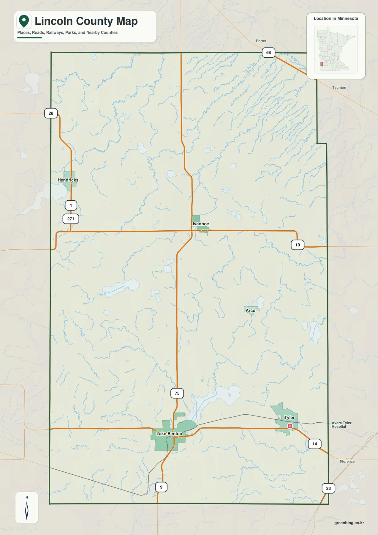
The city map highlights five places and ranks them for quick reference. Tyler and Lake Benton are both in the southern part of Lincoln County, while Ivanhoe is farther north near the center. Hendricks sits apart near the western boundary, and Arco is east of the county’s central north-south road. The pattern is dispersed, so no single town cluster represents the entire county.
Tyler and Lake Benton are useful as a pair because they sit along the southern east-west corridor. Their positions make the southern county easy to recognize even before looking at the lake or elevation layers. Ivanhoe plays a different role: it is a central administrative and road reference point. Hendricks and Arco then help fill in the western and eastern sides, giving readers landmarks away from the main southern corridor.
The ranked city map should not be read as a measure of political or administrative importance. Its value is visual: it separates the principal named communities from the surrounding road and stream detail. That makes it a good first choice for someone who wants to understand where the towns sit before moving to the more information-dense county or water maps.
Roads that organize the county from north to south and east to west
U.S. 75 is the clearest north-south road on the county map. It passes through the central part of Lincoln County and continues toward the Lake Benton area, linking the middle and south in a way that is easy to trace. Minnesota Department of Transportation mapping also shows U.S. 75 as one of the county’s principal trunk highways.
MN 19 crosses east-west through Ivanhoe, creating the most obvious central intersection on the map. Farther south, U.S. 14 runs through the Lake Benton–Tyler area and forms another strong east-west reference. MN 23 appears in the southeast, while MN 68 serves the northern part of the county. Together these routes explain why the major towns are separated into several corridors rather than lining up on one road.
This map is best used to understand relative location and route structure. It is not a live traffic map and does not show current closures, construction detours, seasonal restrictions, or temporary road conditions. For an actual trip, the county map can help with orientation, but current MnDOT information or a navigation service should be checked before driving.
Yellow Medicine River branches shape the northern half
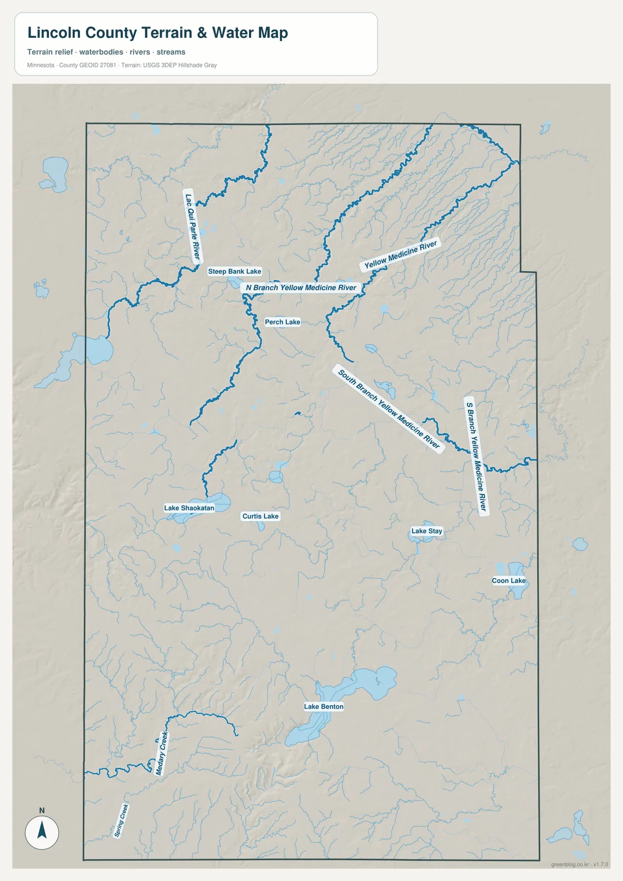
The terrain-and-water map changes the visual emphasis completely. In the north and northeast, the Yellow Medicine River system becomes the dominant feature. The map labels the Yellow Medicine River along with the North Branch and South Branch, and smaller tributaries create a dense pattern around them. These streams are much easier to follow here than on the general county map.
The Lac qui Parle River is labeled in the northwestern part of the county and provides a useful contrast with the Yellow Medicine network. The two systems show that drainage in northern Lincoln County does not converge into one simple channel inside the county. Instead, streams leave the higher ground in several directions and connect with larger river systems beyond the local map area.
A water-reference map has clear limits. It shows named waterways and their relationship to surrounding terrain, but it is not a flood-hazard map, a parcel map, or a navigation chart. Stream width and shoreline detail are generalized for county-scale viewing, so site-specific questions should be checked against the appropriate hydrologic or regulatory source.
Lake Benton and the chain of southern water features
South of the main Yellow Medicine branches, the map becomes more lake-oriented. Lake Benton is the most recognizable water body because it lies next to the city of the same name. Farther northwest, Lake Shaokatan and Curtis Lake provide two additional landmarks, while Lake Stay and Coon Lake appear farther east. This spread of lakes gives the southern half a different look from the stream-heavy northeast.
Medary Creek and Swan Creek are labeled in the southwest, and numerous smaller channels connect the surrounding low areas. On the terrain background, these waterways help reveal shallow valleys and drainage lines that are less obvious on the road-focused map. Comparing the same area across the water and elevation views is especially useful around Lake Benton and the southwestern corner.
The map does not provide lake depth, water quality, public-access rules, or boating information. Those subjects require lake-specific resources. Here, the benefit is geographic context: you can see which lakes are near the principal towns, how creeks sit within the southern terrain, and how the county’s water features differ from north to south.
Higher western ground and a lower northeast
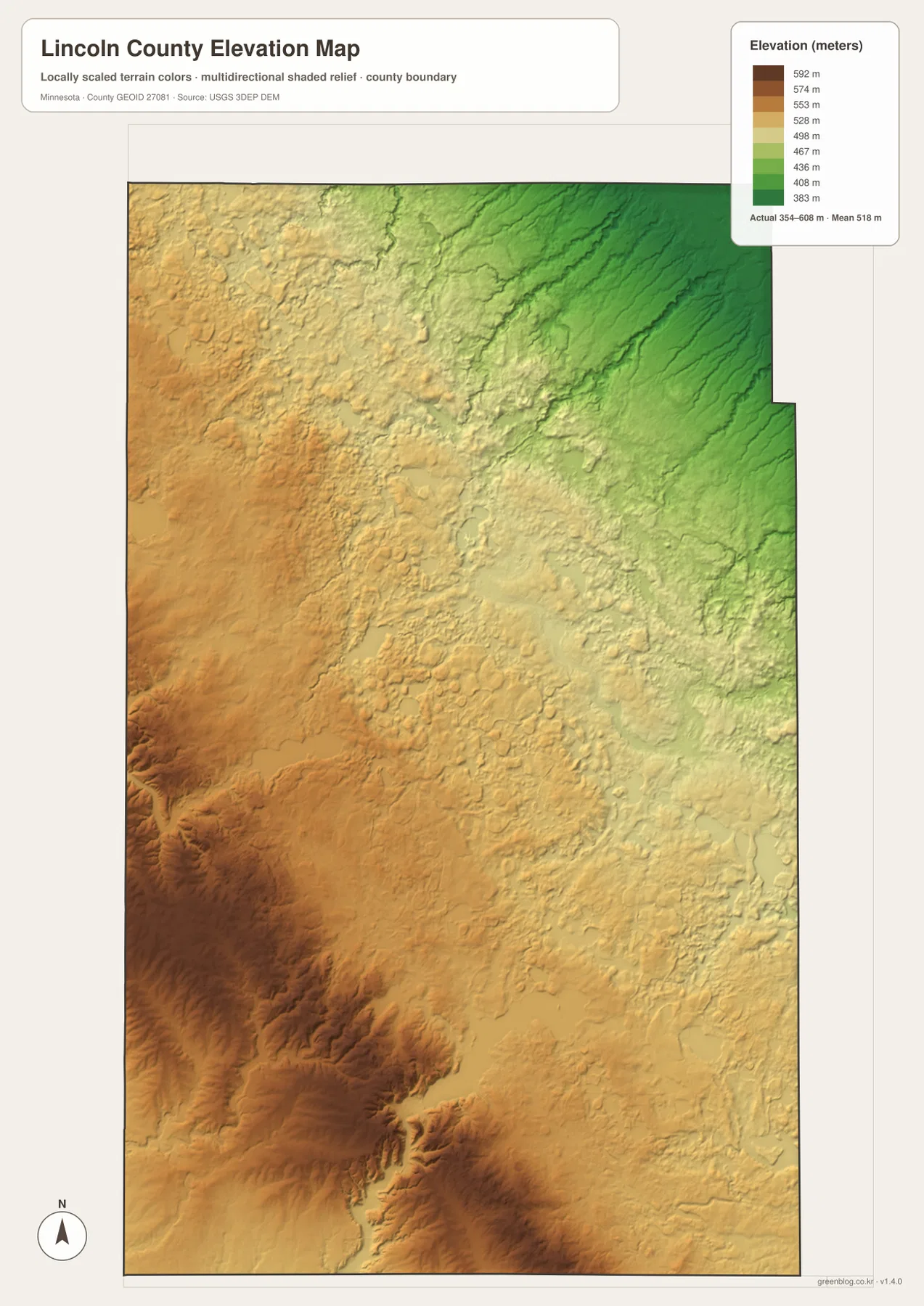
The elevation map shows a strong countywide gradient. Its legend covers roughly 354 to 608 meters and gives a mean of about 518 meters. Brown and tan shades dominate the west and southwest, indicating higher terrain, while greens become more common toward the northeast. The difference is broad enough to see immediately without relying on individual spot elevations.
Relief shading also reveals that the southwest is not uniformly flat. Incised valleys and ridges create a rougher texture, while the central area is more subdued. In the northeast, elongated low areas align with many of the small tributaries seen on the water map. That connection between relief and drainage is one of the most useful reasons to compare the two images rather than viewing either one alone.
This is a generalized elevation surface designed for county-scale comparison. It should not replace survey-grade elevation, engineering data, or a site-specific terrain model. If exact heights are needed, USGS 3D Elevation Program data or professional survey information is more appropriate.
What to look for in each map
County reference map: boundaries, highways, towns, and nearby context
Start with the county reference map when you need one image that combines the main geographic clues. Ivanhoe, Hendricks, Arco, Lake Benton, and Tyler are labeled alongside major highways, the county outline, selected water features, and nearby places outside the boundary. It gives enough detail to orient a reader without making the stream network or elevation shading the main subject.
City map: a cleaner view of settlement distribution
The city map reduces visual competition from road labels and emphasizes where the five highlighted communities sit. Tyler and Lake Benton anchor the south, Ivanhoe occupies the central area, Hendricks marks the western side, and Arco gives the eastern interior a clear reference point. The numbering is useful for quick comparison, but the geographic position of each marker is more important than the rank itself.
Terrain and water map: river branches, creeks, and lakes
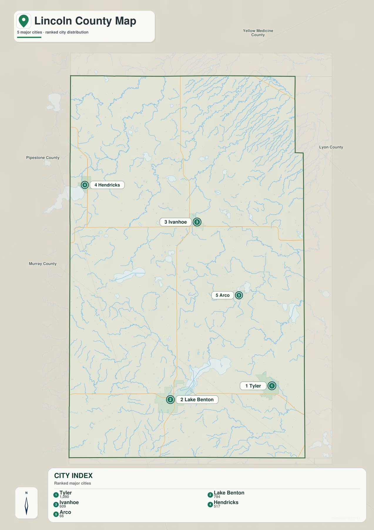
The terrain-and-water view is the better choice for natural features. Yellow Medicine River branches occupy much of the north and east, the Lac qui Parle River appears in the northwest, and southern lakes such as Lake Shaokatan, Curtis Lake, Lake Stay, Coon Lake, and Lake Benton are labeled individually. Subtle relief in the background helps connect these water features to valleys and slopes.
Elevation map: the broad west-to-northeast height change
The elevation map strips away most labels so the land surface becomes the focus. The highest-looking terrain is concentrated in the west and southwest, while the northeast is noticeably lower. Use the legend to interpret the locally scaled colors, and compare the shaded valleys with the water map when you want to understand why many tributaries follow the northeastern low areas.
Choosing the right map for a printout or project
For a general county handout, the reference map is usually the best starting point because it combines towns, roads, water features, and the county outline. If the goal is to teach where the main communities are, the city map is cleaner and faster to read. A local-history presentation can also use the city map to establish where Ivanhoe, Hendricks, Tyler, Lake Benton, and Arco sit before adding photographs or historical material.
Natural-resource topics benefit more from the terrain-and-water map. It separates the Yellow Medicine branches and named lakes clearly enough to discuss drainage and local water geography without crowding the page with highway detail. The elevation map works well beside it because the higher west and lower northeast can be compared directly with the location of streams and valleys.
For printing, the downloaded A3 JPG files provide more detail than the web previews shown in the article. They can be resized for smaller handouts, but the A3 source is useful when labels need to remain readable. If you are making a legal, engineering, emergency-management, or property decision, use the maps here only for orientation and consult the relevant official dataset for the final determination.
Frequently Asked Questions
What is the county seat of Lincoln County, Minnesota?
Ivanhoe is the county seat. It lies near the central part of the county where U.S. 75 and MN 19 provide strong north-south and east-west reference lines. The City of Ivanhoe states that the community has served as the county seat since 1902.
Where are the Yellow Medicine River branches easiest to see?
The terrain-and-water map shows them most clearly in the northern and northeastern parts of Lincoln County. The North Branch and South Branch are labeled separately, and many smaller tributaries are visible around them, making this view more useful than the road-focused county map for drainage questions.
What stands out on the Lincoln County elevation map?
The main pattern is higher ground in the west and southwest and lower terrain toward the northeast. The map legend spans roughly 354 to 608 meters, but the image is intended for broad county-scale comparison rather than survey or engineering measurements.
Map File Information
The ZIP archive contains the Lincoln County reference map, city map, terrain-and-water map, and elevation map as high-resolution A3 JPG files. The web images above are convenient for quick viewing, while the downloadable originals are better suited to printing and document work.
- Printable Size: High-resolution A3 layout
- File Type: Four JPG files in one ZIP archive
Related Maps
Sources and references
County and administrative context can be checked through the official Lincoln County website and the official City of Ivanhoe website. For road placement and route verification, see the Minnesota Department of Transportation general highway map for Lincoln County.
Authoritative background for waterways is available from USGS National Hydrography, and elevation-source information is available through the USGS 3D Elevation Program. For county-specific historical material, the Minnesota Digital Library profile of the Lincoln County Historical Society provides a useful starting point.
These maps are general reference graphics. They should not be used as substitutes for legal boundary surveys, parcel records, flood determinations, engineering plans, emergency-response maps, or other official site-specific products.
Green Map creates custom-edited map images using open geographic data sources such as geoBoundaries, Natural Earth, OpenStreetMap, and government open data. These maps are edited visual materials, not raw data files, and are provided for education, documents, presentations, and graphic reference.