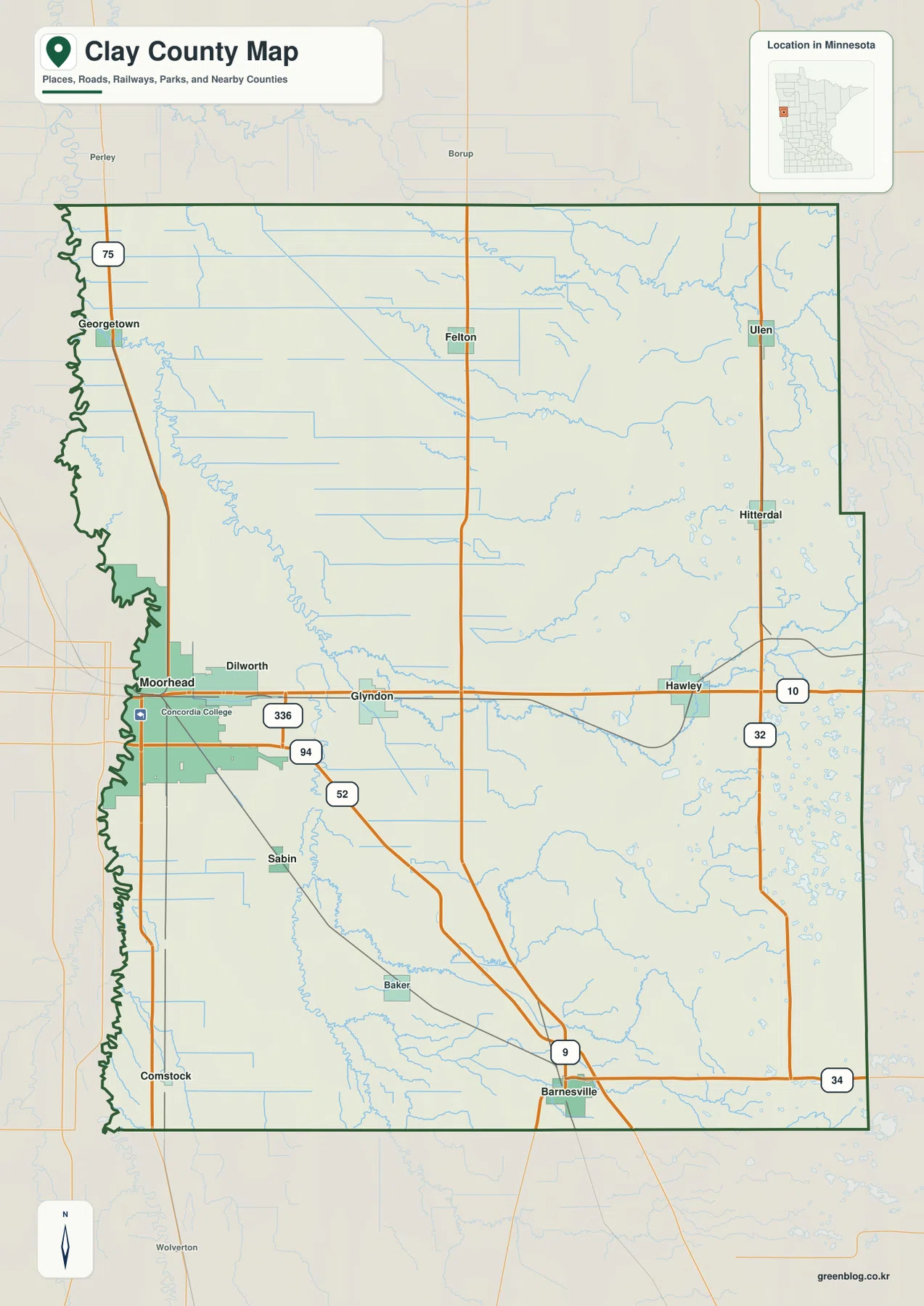
Clay County sits on Minnesota’s western border, where Moorhead and Dilworth occupy the flat Red River plain and the land rises steadily toward rolling hills and lake country in the east. Glyndon and Hawley follow the US-10 corridor, while Georgetown, Ulen, Sabin, and Barnesville are spread across a large agricultural county. The west-to-east terrain change is one of the clearest features in the map set. High-resolution map files are available for download in the section below.
This page combines a general county map, a six-city ranking index, a water map, and an elevation map with an actual range of roughly 259 to 471 meters. High-resolution A3 JPG originals for all four maps are available together in one ZIP for printing, classroom use, trip preparation, and county-scale comparison.
Table of Contents
Moorhead, Glyndon, and Hawley along I-94 and US-10
Moorhead is the dominant urban reference on the general map. It sits directly east of the Red River and connects to the Fargo metropolitan area across the state line. I-94 crosses the southern side of Moorhead and continues east, while US-10 links Dilworth, Glyndon, and Hawley across the county’s central-southern corridor.
US-75 follows the western side through Georgetown and the Moorhead area. Farther east, MN-32 provides a north–south reference near Ulen and Hitterdal, while MN-9 and MN-34 help organize travel around Barnesville in the south. The combination of major east–west and north–south routes makes the road network easy to follow even though the county itself is large.
Glyndon lies between the Moorhead–Dilworth urban area and Hawley, providing a useful midpoint on US-10. Hawley is farther east, near the transition from the very flat Red River plain into more rolling terrain. Felton and Ulen are separated from the main southern road corridor, while Sabin and Barnesville extend the settlement pattern toward the southern county.
Clay County’s 2045 Comprehensive Plan describes western Clay County as flat, rich agricultural land and eastern Clay County as gently rolling hills dotted with lakes, sloughs, and wetlands. That contrast is visible even on the road map: the west has long straight routes across open terrain, while the east contains more water and topographic variation.
Six ranked cities with Moorhead far ahead
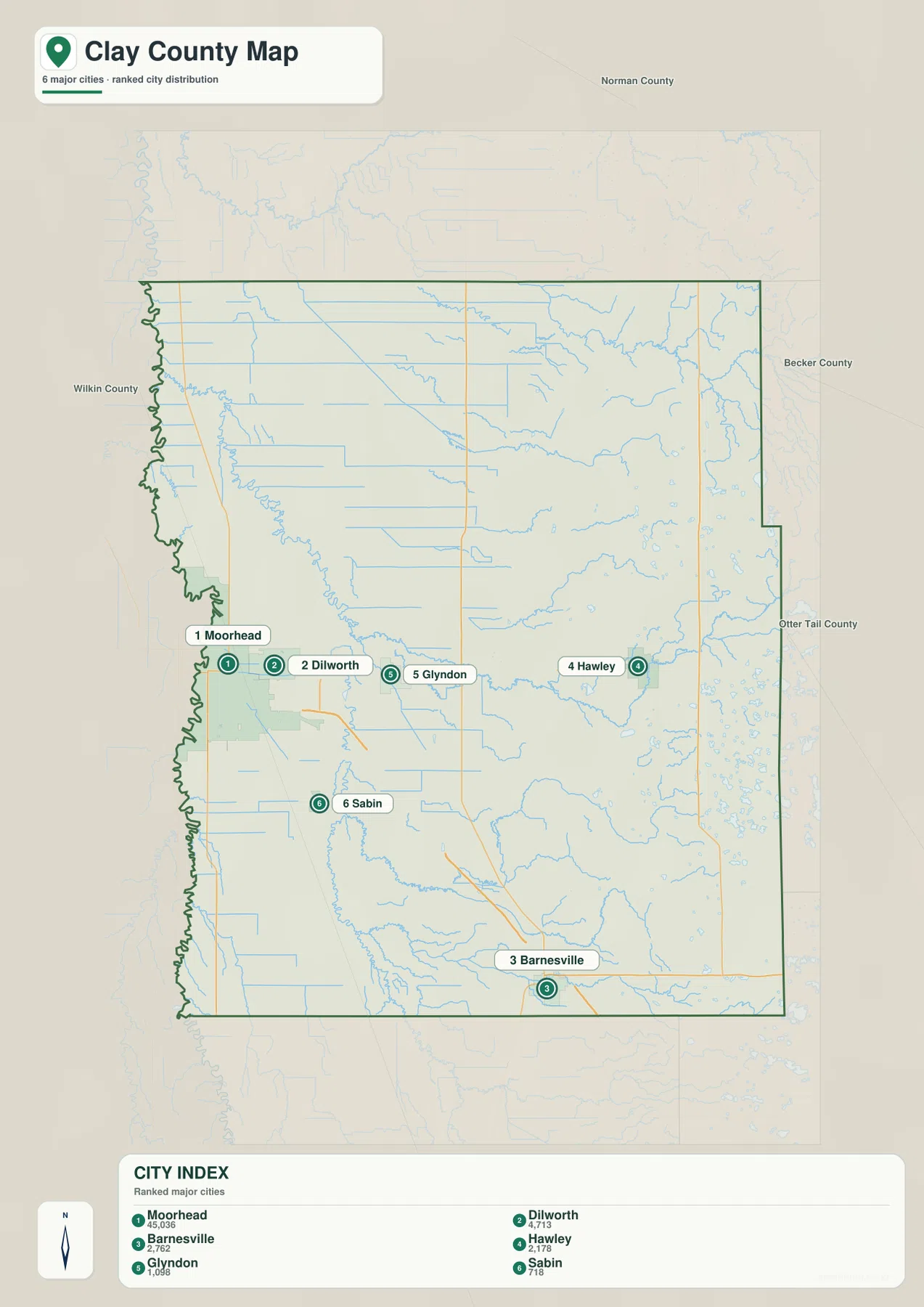
The city index ranks six selected communities. Moorhead is number 1 with a printed value of 45,036, followed by Dilworth at 4,713, Barnesville at 2,762, Hawley at 2,178, Glyndon at 1,098, and Sabin at 718. These figures are reproduced from the supplied city-index graphic and are not presented here as newly calculated population estimates.
Their positions show a strong western concentration. Moorhead and Dilworth sit close together in the southwest, Glyndon and Hawley continue east along the US-10 side, Sabin lies southeast of Moorhead, and Barnesville is much farther south. Moorhead’s printed value is dramatically larger than the others, emphasizing the difference between the Fargo–Moorhead urban edge and the county’s smaller rural cities.
There are no connector lines or mileage labels on this city map. It is a ranking and location graphic rather than a distance chart. Use it to compare where the six selected communities sit within the county, then refer to the general road map or a current routing service when actual driving mileage or travel time is needed.
Red River of the North, Buffalo River, and eastern lake country
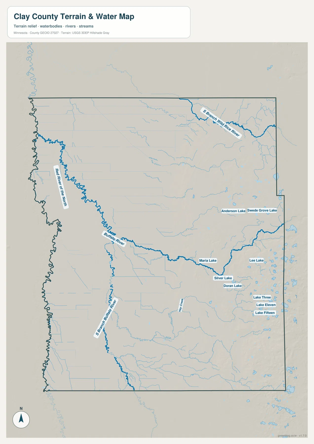
The Red River of the North is the defining western boundary waterway. It follows the Minnesota–North Dakota line beside Moorhead and Georgetown, winding north through the extremely low western plain. Small channels and drainage lines are common across this flat landscape, but large inland lakes are much less prominent here than in the eastern county.
Buffalo River crosses the county from east to west and is the strongest interior river reference. South Branch Buffalo River approaches from the south and joins the system west of Glyndon. Clay County’s comprehensive plan describes Buffalo River as flowing west-northwest through the center of the county before entering the Red River near Georgetown.
The northeastern part of the map contains South Branch Wild Rice River, while the east-central area has Anderson Lake and Swede Grove Lake. Maria Lake, Silver Lake, and Doran Lake lie farther south, and Lee Lake, Lake Three, Lake Eleven, and Lake Fifteen mark a denser lake district near the eastern and southeastern side. This collection of lakes contrasts sharply with the river-and-drainage landscape in the west.
Hay Creek and many smaller unnamed tributaries cross the rolling eastern interior. Their valleys become more visible when compared with the elevation map, where the eastern half sits hundreds of feet above the Red River plain in places. The water map therefore captures a transition from large boundary river and flat drainage country to rolling lake and stream terrain.
Use the water map for names, relative positions, and broad drainage relationships. It does not show flood probability, legal shoreline limits, navigation depth, parcel ownership, or current water conditions. Those questions require current products from the responsible public agency.
Elevation from 259 to 471 meters
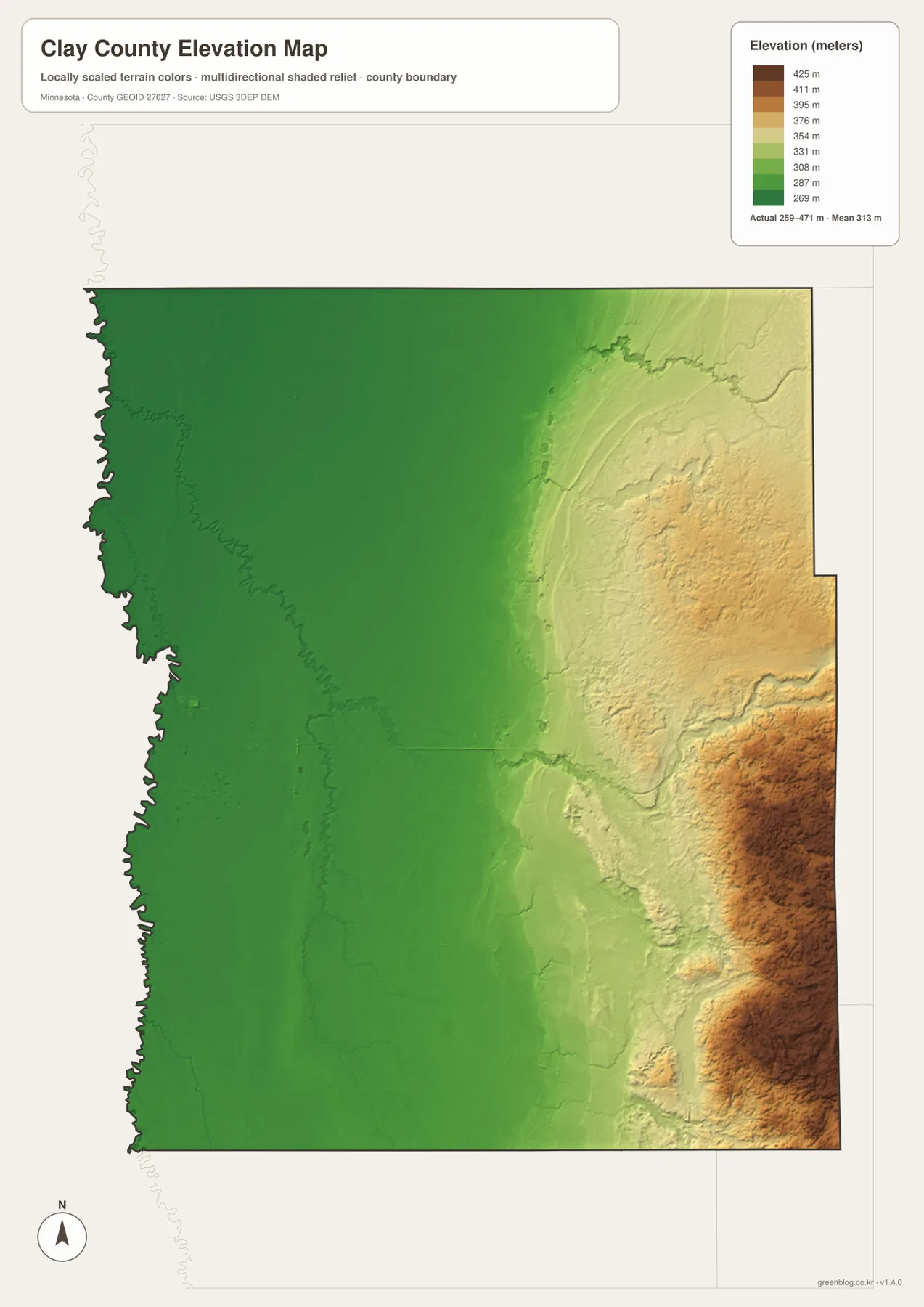
The elevation map reports an actual range of about 259 to 471 meters and a mean near 313 meters. Greens represent lower terrain, while tan and brown colors mark higher ground. The entire western half forms a broad, dark-green low plain beside the Red River, with very little local relief around Moorhead and Georgetown.
Elevation begins to rise through the center of the county and changes much more sharply in the east. Clay County’s comprehensive plan identifies a series of former Glacial Lake Agassiz beach ridges running roughly north–south through the middle of the county. On the terrain map, that transition appears as a gradual rise between the flat west and the rolling eastern uplands.
The highest ground is concentrated near the eastern and southeastern edge, where large brown hills stand well above the Red River plain. Small stream valleys and lake basins cut into this high terrain, producing a much rougher surface around the Hawley–Hitterdal side and farther east than around Moorhead.
The county-wide difference is roughly 212 meters, a large internal change for a county dominated by agricultural land. This surface is intended for broad terrain comparison rather than survey-grade measurement. Precise construction, drainage, engineering, or site work requires more detailed official elevation data and field verification.
Moorhead, Glyndon, and Hawley reveal the west-to-east transition
Moorhead represents the county’s lowest and most urbanized setting. I-94, US-75, and city streets converge beside the Red River, while the elevation layer shows a broad plain with almost no strong hills. Dilworth extends the developed area eastward, but the landscape remains low and flat.
Around Glyndon, US-10 remains the main road reference while Buffalo River becomes a stronger geographic feature. The county plan notes that South Branch Buffalo River joins the main river west of Glyndon, helping explain the concentration of drainage lines across the central plain. The terrain has begun to rise here, but it is still much lower than the far east.
Hawley marks the approach to Clay County’s rolling eastern landscape. Small lakes become more numerous, stream valleys are more visible, and elevation increases rapidly toward the eastern boundary. The difference between Moorhead’s flat metropolitan edge and the lake-dotted eastern uplands is the most useful county-wide comparison across the four maps.
Clay County’s official profile highlights its I-94 connections, agricultural economy, and resources such as Buffalo River State Park. The map set works well for general orientation, school assignments, local-history presentations, and trip preparation, but parcel boundaries, flood regulation, legal boundaries, and live road conditions should be checked with current county, state, or federal sources.
Frequently Asked Questions
Which maps best show the difference between Moorhead and Hawley?
Start with the general county map to compare their locations along the major road corridors, then use the elevation map. Moorhead sits on the very flat Red River plain, while terrain rises toward Hawley and becomes much more rolling farther east.
Are the city-index values current population estimates?
The values described here are the numbers printed in the supplied city-index graphic. For the latest population figures, use current U.S. Census Bureau or Clay County statistics rather than treating the map values as a new estimate.
Can the 259–471 meter elevation range be used for engineering or surveying?
No. The elevation layer is suitable for broad comparison of higher and lower terrain, but precise construction, drainage, engineering, or survey work requires more detailed official elevation data and field verification.
Map File Information
A ZIP containing the high-resolution A3 JPG originals for the Clay County map, city index, water map, and elevation map.
- Included Files: county map, city index map, water map, elevation map
- File Type: JPG
Related Maps
Sources and references
- U.S. Census Bureau TIGER/Line Shapefiles – official geographic files for county boundaries, roads, and place references.
- USGS National Hydrography – federal source for rivers, streams, lakes, and other hydrographic features.
- USGS 3D Elevation Program – official U.S. elevation and terrain data resources.
- Clay County About Us – official county profile covering location, transportation, agriculture, education, and recreation.
- Clay County 2045 Comprehensive Plan – official planning document describing the Red River plain, Buffalo River, former Lake Agassiz beach ridges, and rolling eastern terrain.
Green Map creates custom-edited map images using open geographic data sources such as geoBoundaries, Natural Earth, OpenStreetMap, and government open data. These maps are edited visual materials, not raw data files, and are provided for education, documents, presentations, and graphic reference.