Clearwater County stretches north to south across northwestern Minnesota, with a shape that becomes noticeably narrower toward its southern end. Bagley provides the clearest reference point near the south-central part of the county, while Clearbrook and Gonvick sit farther northwest, Shevlin lies to the east of Bagley, and tiny Leonard appears in the eastern interior. The maps on this page bring those places together with the county boundary, road network, rivers, lakes, and a broad view of terrain.
You can view each map on the page and download the original high-resolution JPG files as one ZIP archive. The set is especially useful for comparing the flatter northern part of Clearwater County with the hillier south, following the Clearwater River across the middle, and locating Lake Itasca and the beginning of the Mississippi River near the county’s southeastern corner.
Table of Contents
A long county outline linking Bagley with the northern townships
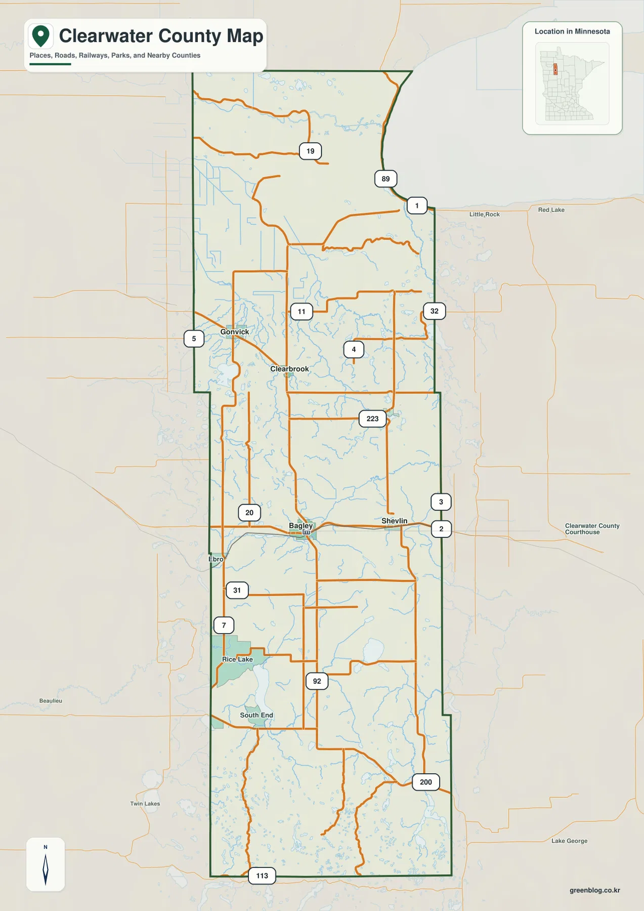
The general county map makes Clearwater County’s unusual outline easy to recognize. Its northern section is relatively broad, but the eastern edge curves inward before the county continues south in a narrower strip. That geometry matters when reading the map because communities that belong to the same county can be much closer to neighboring counties than to places at the opposite end of Clearwater County. Labels around the perimeter include Polk, Mahnomen, Hubbard, Beltrami, Pennington, Becker, and Red Lake counties, helping establish the wider regional setting.
Bagley sits at an important road junction in the south-central part of the county, with Shevlin nearby to the east. Clearbrook and Gonvick form a smaller cluster farther northwest, while Rice Lake and South End appear farther south. The road pattern is more useful here as an orientation system than as a turn-by-turn network: several east-west routes cross north-south roads, giving readers a quick sense of how the scattered communities relate to one another across a long rural county.
The county government’s official website places its administrative services and mapping resources in Bagley, reinforcing the city’s role as a practical reference point for the county. U.S. Census Bureau QuickFacts lists a July 1, 2025 population estimate of 8,647 for Clearwater County. That modest population spread over a large rural area helps explain why the map shows a handful of small cities separated by broad tracts of countryside rather than one continuous urban corridor.
Five mapped cities split between the northwest and south-central county
The city distribution map highlights five incorporated places: Bagley, Clearbrook, Gonvick, Shevlin, and Leonard. Bagley is ranked first on the map and occupies the most central position for the populated south-central section. Clearbrook and Gonvick sit relatively close together in the northwest, while Shevlin lies east of Bagley. Leonard is farther north in the eastern interior and is much smaller than the other labeled communities.
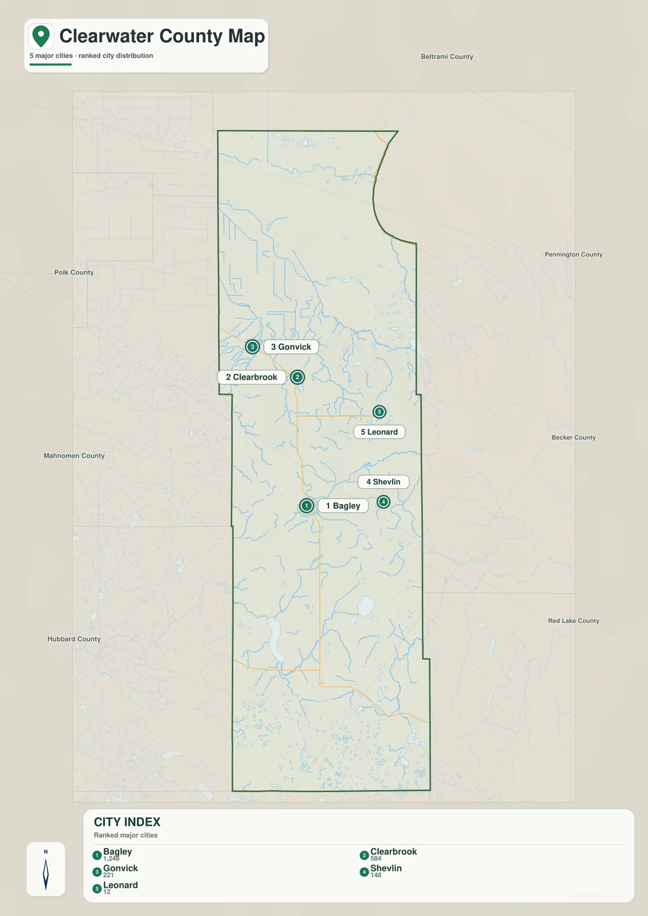
The surrounding county labels also make the local geography easier to read. Shevlin and Leonard are closer to the eastern side of Clearwater County, Gonvick is nearer the western boundary, and Bagley lies slightly south of the county’s midpoint. This arrangement creates two visually distinct groups: the Clearbrook-Gonvick area in the northwest and the Bagley-Shevlin area farther south. A reader comparing schools, community locations, or regional travel can use this simplified view before moving to the more detailed county map for roads.
This map is not a driving-distance chart and does not replace a navigation service. Its strength is the uncluttered comparison of where the principal cities sit inside the county boundary. For trips or local research, it works best beside the general map: one map keeps the city pattern simple, while the other restores the roads, smaller place labels, and the surrounding geography needed for context.
From the Clearwater River to Lake Itasca: several watersheds in one county
The terrain and water map shows that Clearwater County is crossed by more than one major river system. The Clearwater River is the most prominent named stream through the central part of the county. North of it, the Red Lake River and Sandy River appear in the broad northern section, while the Lost River is labeled farther west. Pine Lake and West Four Legged Lake provide recognizable water landmarks in the central area. Farther south, Upper Rice Lake, Lower Rice Lake, the Wild Rice River, and Gill Lake add a denser mix of lakes and streams.
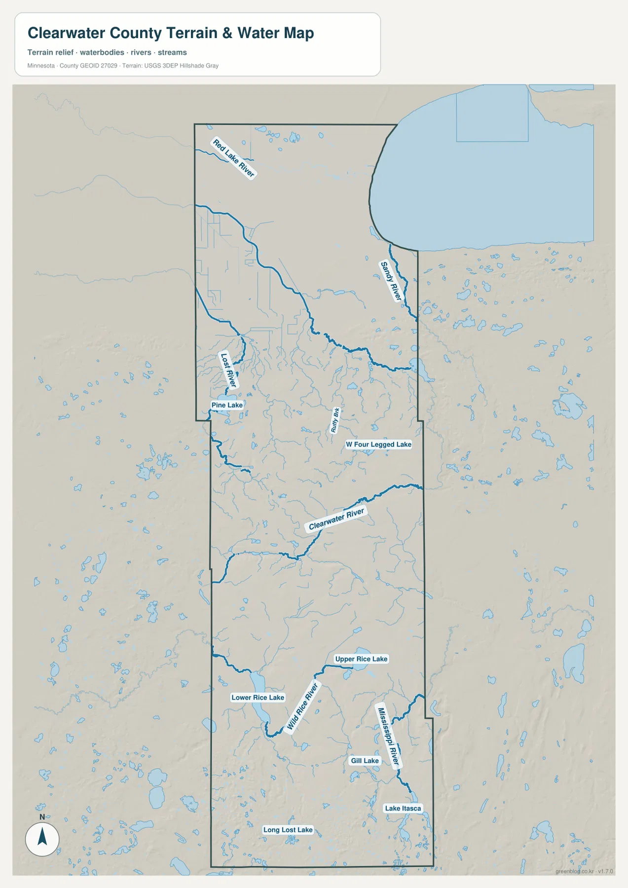
The southeastern end of the county contains one of Minnesota’s most recognizable water features. Minnesota’s Department of Natural Resources identifies Lake Itasca in Itasca State Park as the headwaters of the Mississippi River. State information also places the park mainly in southeastern Clearwater County, with smaller portions extending into neighboring counties. On the map, Lake Itasca and the upper Mississippi sit close to the county’s southeastern edge, giving a clear geographic connection between Clearwater County and the river’s starting point.
The water map should be used as a regional reference rather than as a flood, boating, parcel, or legal-boundary product. A stream shown here indicates where the watercourse lies in relation to the county and terrain, but it does not establish navigable conditions, flood insurance zones, shoreland setbacks, or ownership. Those questions require the appropriate Minnesota DNR, county, federal, or survey records. For geographic learning, however, the map is particularly effective because it shows how many named rivers and lakes occupy different parts of the same long county.
Elevation rises from the broad northern lowland into the southern hills
The elevation map reveals a strong north-to-south contrast that is less obvious on the road map. Its legend gives an actual elevation range of roughly 354 to 609 meters and a mean near 432 meters. Darker greens dominate the north, showing the lower part of the county. Moving south, the map shifts through lighter greens and yellow-green tones before larger tan and brown areas appear in the southern third. The result is a clear picture of a county that generally gains elevation toward its southern end.
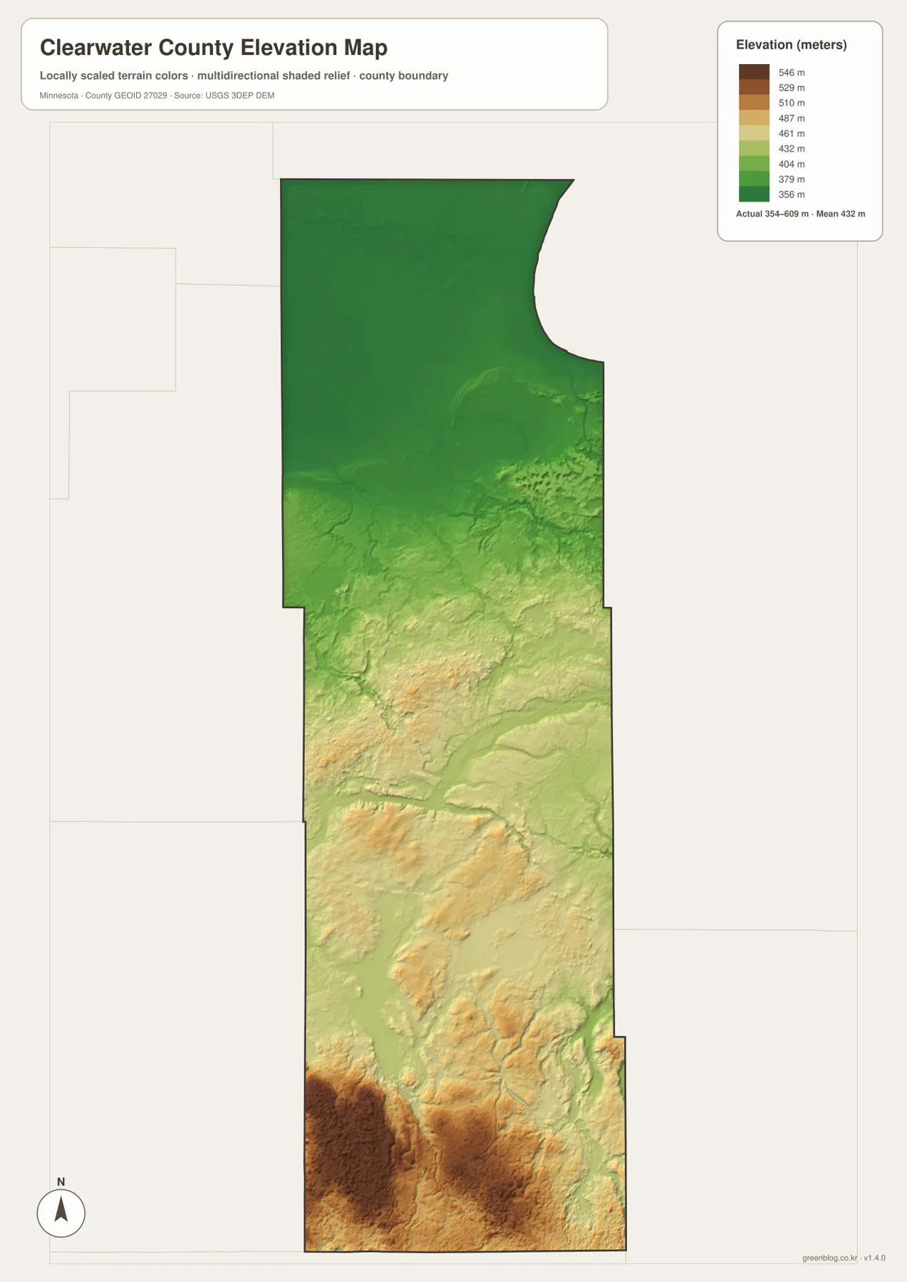
Several rounded high areas stand out in the southwest and south-central county, while the Lake Itasca area in the southeast also has more terrain texture than the broad northern lowland. Looking back at the water map helps explain why the southern landscape contains so many small lakes and winding streams: the terrain is more irregular, with local rises and depressions that are muted or absent in the far north. The two maps complement each other without requiring technical terrain analysis.
This surface is generalized for county-scale viewing. It is useful for comparing broad relief, but it should not be treated as a survey-grade or engineering-grade elevation source. A construction project, parcel survey, drainage design, or other site-specific decision needs higher-resolution official data and professional measurements. The USGS 3D Elevation Program is an appropriate source for more detailed elevation datasets, while this map remains a quick visual guide to the county’s large-scale terrain.
Choosing the most useful Clearwater County map for the task
For a first look at Clearwater County, start with the general map because it combines the boundary, cities, roads, and neighboring counties. Switch to the city map when the goal is simply to compare Bagley, Clearbrook, Gonvick, Shevlin, and Leonard without extra detail. The water map is the better choice for finding the Clearwater River, Wild Rice River, Lake Itasca, or the upper Mississippi, while the elevation map answers a different question by showing where the land is lower or higher.
The maps also lend themselves to different presentation styles. A classroom handout or county overview may benefit from the general map because names and roads give immediate orientation. A slide about settlement patterns can stay cleaner with the city map. A discussion of the Mississippi headwaters or local watersheds needs the water map, and a comparison of the northern lowland with the southern hills is easiest with the elevation version. Using the maps together adds depth without forcing one crowded graphic to do every job.
None of these maps replaces authoritative boundary, hydrography, or survey records. For official geographic data, the U.S. Census Bureau’s TIGER/Line files provide boundary and transportation layers, USGS National Hydrography provides water data, and USGS 3DEP provides elevation data. The county’s own mapping services are also useful when a question depends on local parcels or administrative information. Treating the downloadable maps as readable regional references, and the official datasets as the source for technical work, keeps the purpose of each resource clear.
Frequently Asked Questions
Is Lake Itasca and the Mississippi River headwaters area in Clearwater County?
Yes. Most of Itasca State Park is in southeastern Clearwater County, and Lake Itasca is the source of the Mississippi River. Smaller portions of the park extend into neighboring counties, so the park boundary and Clearwater County boundary are not identical. The water map on this page shows Lake Itasca and the young Mississippi near the county’s southeastern edge.
Which map is best for comparing Bagley, Clearbrook, Gonvick, and Shevlin?
The city map is the clearest choice when you only need the relative positions of the principal communities. Pair it with the general county map when roads matter as well. Bagley and Shevlin form the more southerly grouping, while Clearbrook and Gonvick sit together farther northwest, a pattern that is easier to see on the simplified city view.
Can the elevation map be used for surveying or construction measurements?
No. The elevation layer is generalized for county-scale comparison and is intended to show broad differences such as the lower north and higher southern hills. Site design, surveying, grading, drainage, and construction require official high-resolution elevation data and appropriate field measurements.
Map File Information
The ZIP archive contains the original high-resolution JPG versions of all four Clearwater County maps shown on this page.
- Included Files: county map, city map, terrain and water map, elevation map
- File Type: ZIP containing 4 JPG images
Related Maps
Sources and references
- Clearwater County, Minnesota official website – county services, mapping, and local information
- U.S. Census Bureau QuickFacts: Clearwater County, Minnesota – population and county statistics
- Minnesota DNR: Mississippi River Headwaters – Lake Itasca and the river’s source
- U.S. Census Bureau TIGER/Line Shapefiles – official geographic boundary data
- USGS National Hydrography – river and water data
- USGS 3D Elevation Program – elevation data and products
Green Map creates custom-edited map images using open geographic data sources such as geoBoundaries, Natural Earth, OpenStreetMap, and government open data. These maps are edited visual materials, not raw data files, and are provided for education, documents, presentations, and graphic reference.