Marquette County covers a large part of Michigan’s central Upper Peninsula, and the quickest way to orient yourself is to begin at Marquette on Lake Superior and then follow US-41/M-28 west through Negaunee to Ishpeming. That three-city line occupies only part of the county. Big Bay lies well to the north, Gwinn and K.I. Sawyer sit to the south, and Republic and Michigamme provide western reference points across a much broader interior. The maps on this page separate roads and places, city spacing, water features, and relief so each pattern is easier to see. High-resolution JPG originals of all four maps are also available together in the download box below.
Official Marquette County information and the Library of Michigan county guide identify Marquette as the county seat, which matches the courthouse marker on the supplied general map. Yet the county is not simply a coastal urban area centered on Marquette. Lake Independence and the Yellow Dog River mark the north, the Dead River crosses the central interior, and Lake Michigamme anchors the southwest. The elevation map adds another important contrast: the Lake Superior edge is relatively low, while much of the western and central interior rises into much higher terrain. Looking at those features together makes the county’s size and variety much clearer.
Table of Contents
Start at Marquette, then follow US-41 and M-28 west to Negaunee and Ishpeming
Marquette is the most obvious eastern anchor on the general map because it sits directly on Lake Superior and contains the marked county courthouse. US-41 and M-28 leave the city toward the west, pass Negaunee, and continue through Ishpeming. The three communities are close enough that they read as a connected group even though the county extends far beyond them. For a first look at Marquette County, this route provides a simple backbone: shore at Marquette, then inland through Negaunee and Ishpeming before the map opens toward Michigamme and the western interior.
Other roads branch away from that central route and help show the county’s reach. M-35 turns south through Palmer toward Gwinn. M-94 and M-460 serve the K.I. Sawyer area farther southeast, while M-95 passes near Republic in the west. The road network therefore changes from a compact east-west urban section into longer connections toward smaller communities and large stretches of undeveloped interior. This general map is useful for broad orientation, but it does not show live traffic, construction, winter closures, or driving time, all of which matter in Upper Peninsula travel.
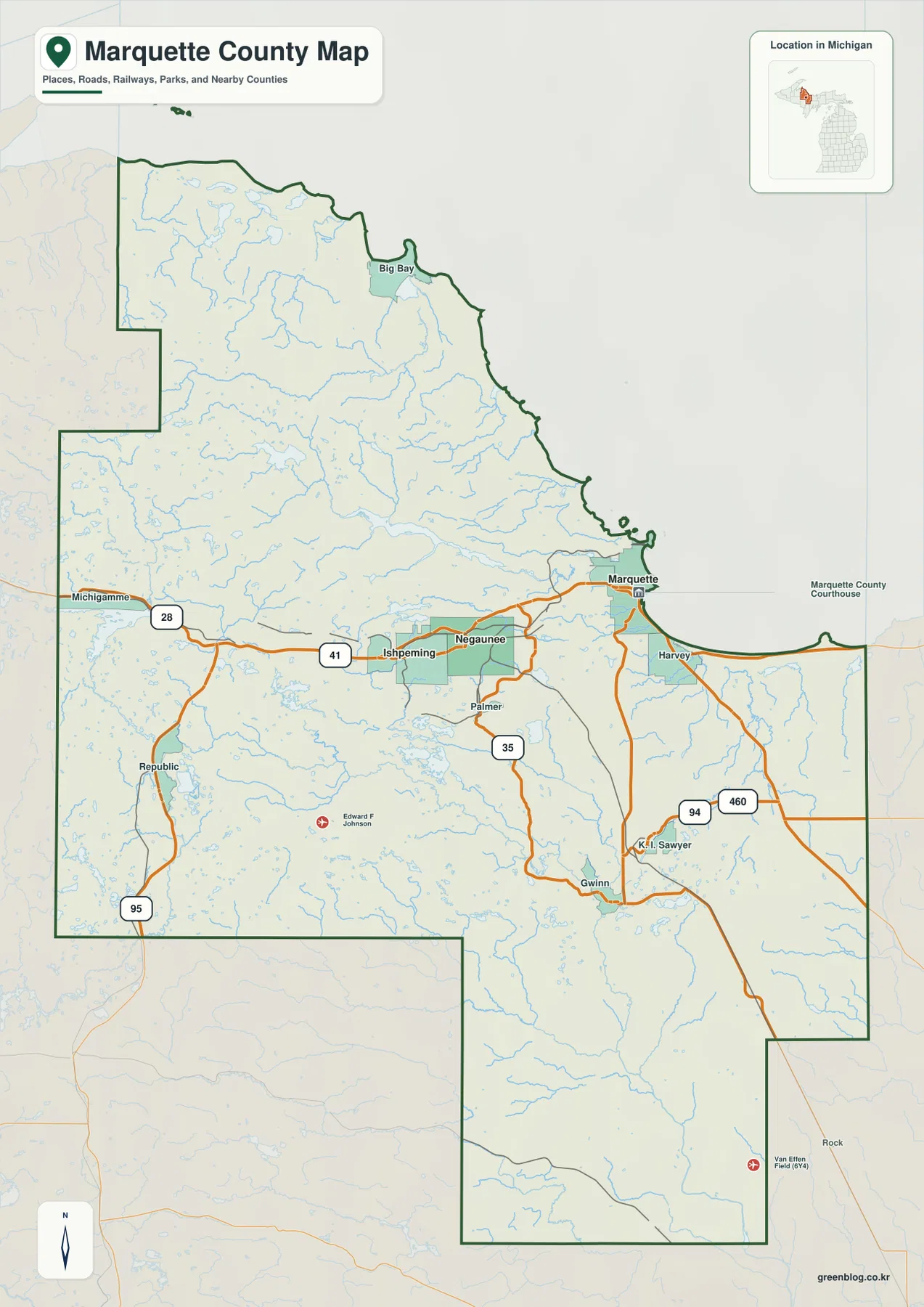
The full county outline matters because Marquette County is not a simple rectangle. Lake Superior forms much of the northern and northeastern edge, Baraga County lies to the west, Alger County is to the east, and Delta and Menominee counties lie along the southern side. Several large steps in the boundary make western and southern locations look farther apart than a quick glance at the central cities might suggest. For county-scale reference, the supplied map is sufficient. Property ownership, legal boundary questions, permitting, and parcel research should instead rely on current Census boundary files and Marquette County’s official GIS resources.
Big Bay and Gwinn reveal how far the county extends beyond the three-city cluster
The city-connections map intentionally removes many place names and keeps only Marquette, Ishpeming, and Negaunee. Marquette is labeled first on the Lake Superior side, Negaunee sits immediately to the west, and Ishpeming is farther west again. The map lists straight-line distances from Marquette of about 10 miles to Negaunee and 13 miles to Ishpeming. Those numbers are not road mileage, but they show why the three communities feel compact when compared with the county’s much larger north-south and east-west dimensions.
Switching back to the general map after viewing the simplified city version changes the sense of scale. Big Bay lies far north along Lake Superior, while Gwinn and K.I. Sawyer are well south of the main three-city line. Republic and Michigamme establish separate western anchors. These places are omitted from the city index because that map is designed to compare the three highlighted centers, not because they are unimportant. For lessons or presentations, the city map works well as a first step, and the general map can then expand the story to the rest of the county.
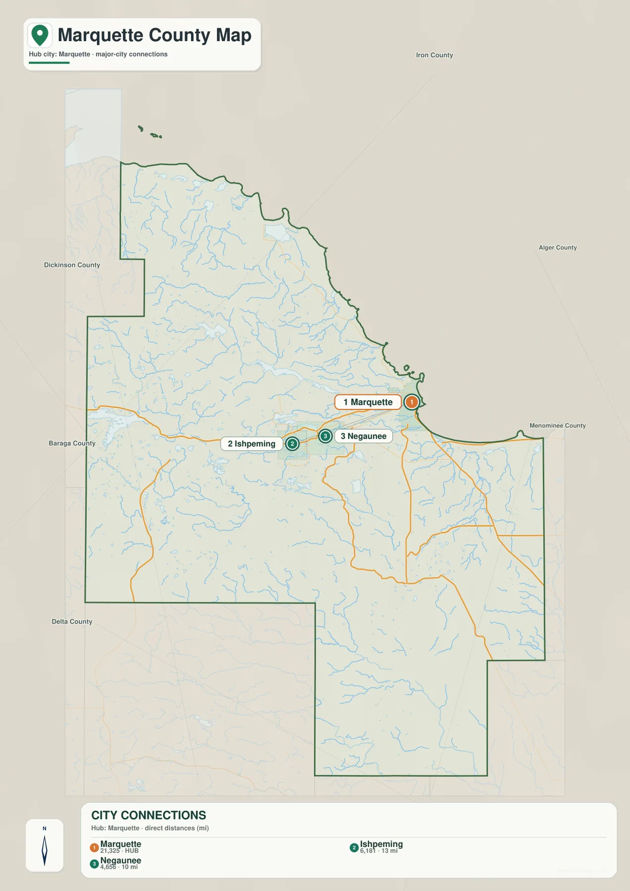
The three-city grouping also helps explain the later elevation map. Marquette stands near the low Lake Superior shore, while Negaunee and Ishpeming lie progressively farther inland, closer to the higher country that occupies much of the western and central county. The city map does not show elevation by itself, but it provides the place names needed to compare settlement with relief. It is also important to keep the distance labels in context: straight-line distance measures the gap between map points, not the length or time of an actual drive.
Dead River, Yellow Dog River, and Lake Michigamme give the interior its water landmarks
The terrain-and-water map replaces much of the road emphasis with rivers, lakes, reservoirs, and shaded ground. In the northwestern part of the county, Lake Independence and the Yellow Dog River stand out near the Lake Superior side. Farther south, the Dead River and the labeled Dead River Basin cross the central interior, with Silver Lake Basin nearby. Areas that looked relatively empty on the road map become much more detailed here because small tributaries and lakes fill the land between the main communities.
The southwest has another set of easy reference points. Lake Michigamme and the Michigamme River occupy the western side, and the Middle Branch Escanaba River crosses the south-central interior. Greenwood Reservoir is prominent farther east. Closer to Marquette, the Carp River provides a named line through the central-eastern part of the county, while the Chocolay River reaches the lower country near Lake Superior. Rather than being organized around one dominant river, Marquette County contains several separate water systems that make different parts of the interior easier to identify.
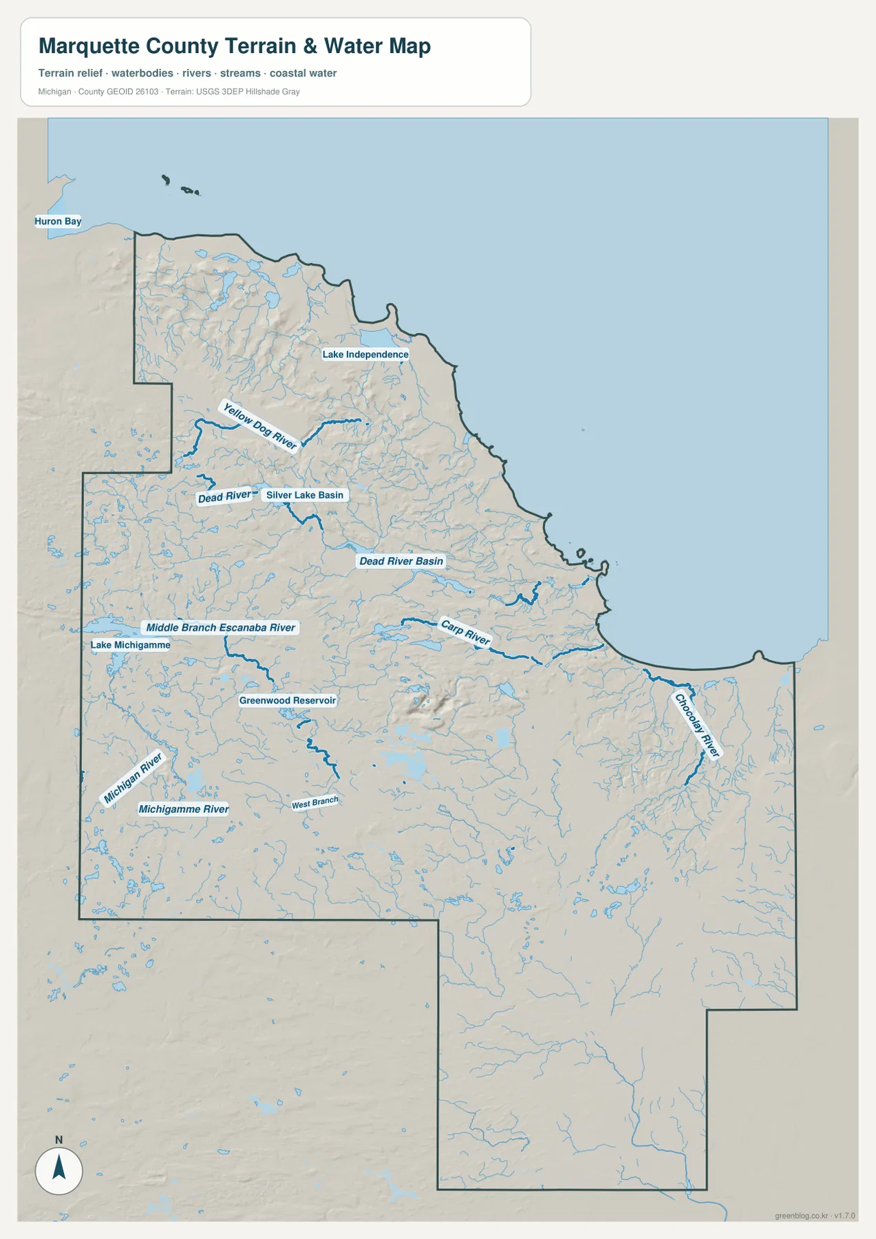
This water map is meant for geographic reference, not for flood decisions or boating navigation. It does not show current discharge, water depth, dam operations, flood stage, wetland jurisdiction, or navigation hazards. Reservoir levels and stream conditions can also change over time. For current hydrologic information, the USGS National Hydrography program and local agencies are better sources. The map’s strength is simply that it lets a reader connect named rivers and lakes with the county outline and nearby communities.
The Lake Superior edge stays low while western and central uplands rise sharply
The elevation map makes the shoreline-to-interior contrast immediately visible. Green colors follow much of the Lake Superior shore around Marquette and north toward Big Bay. Moving west and southwest, the colors pass through lighter green and yellow before broad brown areas appear across the interior. The legend uses locally scaled steps from about 192 to 538 meters, while the map annotation reports an actual county range of roughly 93 to 612 meters and a mean near 380 meters. Those figures describe the broad relief shown on this particular county map.
Negaunee and Ishpeming lie much closer to the higher interior colors than Marquette does. West and northwest of the city group, shaded ridges and valleys are especially strong, and the Yellow Dog and Dead River areas cut across that uneven ground. The southern interior is generally lower than the darkest western uplands but is still far from uniformly flat. Comparing the water and elevation maps side by side helps explain why so many streams occupy valleys between higher areas before reaching lakes, reservoirs, or the lower Lake Superior shore.
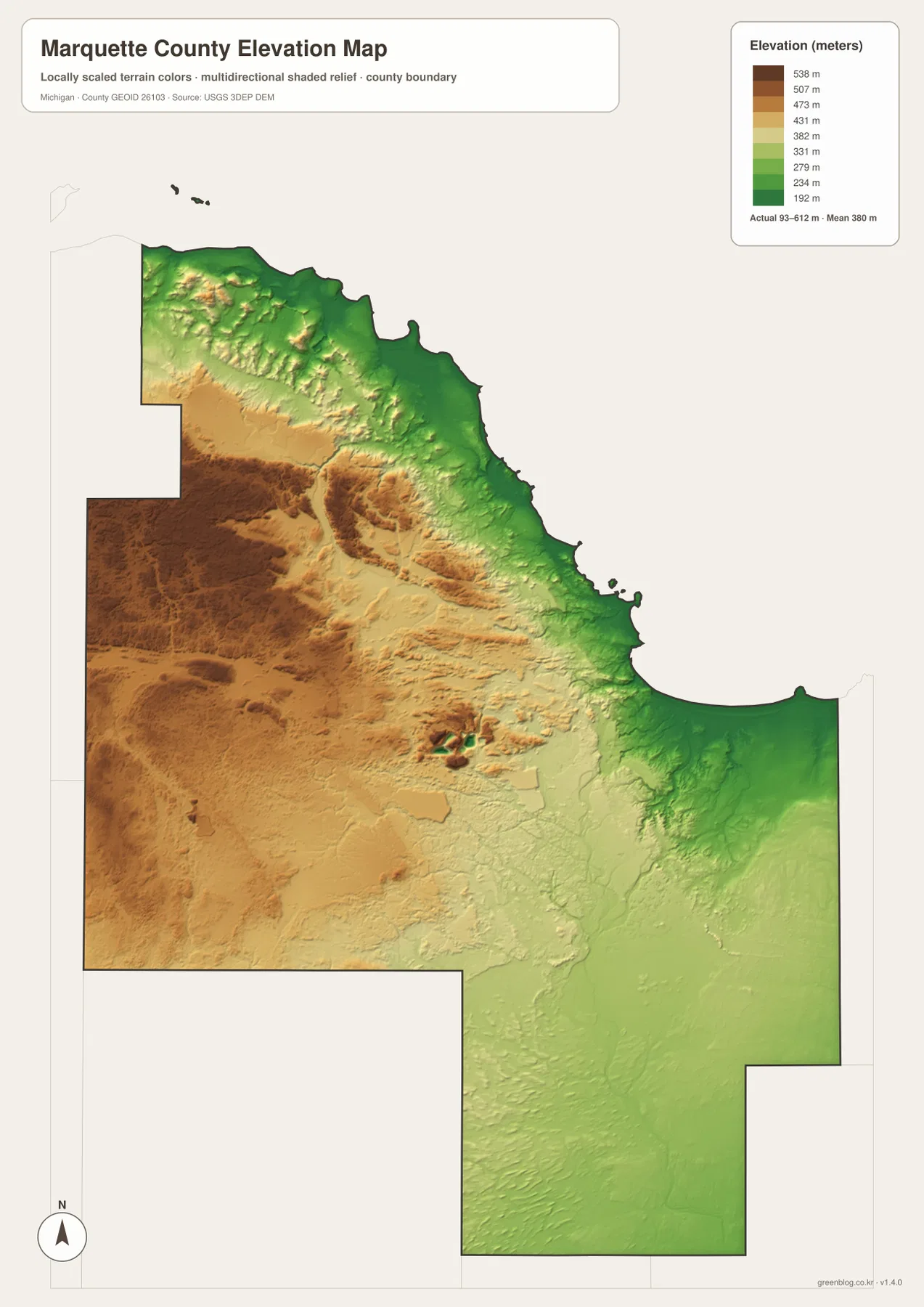
The colored surface should not be treated as a site survey. It is designed to compare relative high and low areas across the county, not to establish the exact elevation of a building pad, road grade, parcel corner, mine site, or drainage structure. Engineering, construction, grading, mining, and professional surveying require original elevation data and, when needed, field measurements. The USGS 3D Elevation Program is the appropriate starting point when numeric elevation accuracy matters.
Use Marquette, Big Bay, Michigamme, and Gwinn as four anchors for the full county
A simple way to remember the county is to build outward from Marquette. First follow US-41/M-28 west through Negaunee and Ishpeming. Then move north to Big Bay and Lake Independence, which establish the northern Lake Superior side. Next look west toward Michigamme and Lake Michigamme, and finally add Gwinn and K.I. Sawyer in the south. With those anchors in place, Dead River, Carp River, Greenwood Reservoir, Republic, and the major state routes become much easier to fit into the map.
Each map is best for a different question. The general map combines the county outline with communities and roads. The city map is the clearest choice when the goal is to compare Marquette, Negaunee, and Ishpeming without extra labels. The terrain-and-water map is much better for Yellow Dog River, Dead River, Lake Michigamme, and other named waters. The elevation map is the one to use when explaining why the Lake Superior side looks low and the western interior looks much higher. Moving among the four versions is more useful than trying to force every detail onto a single crowded map.
The WebP images in the article are optimized for quick viewing on a web page. The ZIP contains the original 3638 × 2572 pixel JPG files, which are better for printing, large classroom handouts, presentations, or closer inspection of smaller road and water labels. These files are general geographic reference maps. They should not replace live navigation, parcel and legal-boundary records, flood-regulation maps, nautical products, or survey- and engineering-grade elevation sources.
Frequently Asked Questions
Why are Marquette, Negaunee, and Ishpeming shown so close together?
They occupy the same central east-west part of the county and are connected by US-41/M-28. The city map lists straight-line distances from Marquette of about 10 miles to Negaunee and 13 miles to Ishpeming, so the three places form a compact group compared with the county’s much larger overall dimensions.
Which map should I use to compare Dead River and Yellow Dog River?
Use the terrain-and-water map. Yellow Dog River and Lake Independence are shown in the north, while Dead River and Silver Lake Basin are farther south across the central interior. The same map also includes Lake Michigamme, Michigamme River, Greenwood Reservoir, Carp River, and Chocolay River for a broader comparison.
Can I use the 93–612 m elevation range for a construction or survey project?
No. That range is the broad value printed on the supplied county elevation map and does not establish the exact elevation of an individual parcel, road, or building site. Construction, drainage design, mining, road engineering, and surveying require original elevation datasets and, when appropriate, professional field measurements.
Map File Information
The ZIP contains four high-resolution JPG originals for Marquette County: the county map, city map, terrain-and-water map, and elevation map. These files are larger than the WebP images used in the article and are better suited to printing or close inspection.
- Included Files: Use only the versions confirmed in the article and supplied images
- File Type: Use the confirmed download contents
- Intended Use: Printing, education, presentations, and map-based projects
Related Maps
Sources and references
- Marquette County – About Marquette County: official county information and local context.
- Marquette County – GIS Mapping: official county mapping and GIS resources.
- Library of Michigan – Marquette County Guide: state reference guide for county history, maps, and records.
- U.S. Census Bureau TIGER/Line Shapefiles: official boundary and road reference data.
- USGS National Hydrography: official reference for rivers, streams, lakes, and hydrography.
- USGS 3D Elevation Program: official elevation data reference.
Green Map creates custom-edited map images using open geographic data sources such as geoBoundaries, Natural Earth, OpenStreetMap, and government open data. These maps are edited visual materials, not raw data files, and are provided for education, documents, presentations, and graphic reference.