Lake County sits in the west-central part of Michigan’s Lower Peninsula, and its geography is easier to understand from rivers and roads than from a large urban skyline. Baldwin is the main reference point in the southern part of the county, where M-37 and US-10 cross. Luther lies farther northeast, while the Little Manistee River, Pine River, and branches of the Pere Marquette occupy different parts of the county. The high-resolution JPG versions of all four maps are available in the download box below for printing or closer viewing.
The county’s name also fits what appears on the terrain and water sheet. The Library of Michigan notes that the area was first organized as Aischum County in 1840 and was renamed Lake County in 1843 for its lakes. Big Bass Lake, Seaman Lake, Cranberry Lake, Wolf Lake, Cecilia Lake, and Big Star Lake are among the named waters visible on the supplied map. Those lakes are useful local landmarks, but the quickest way to orient yourself is to begin with Baldwin, the two trunk highways, and the three major river systems shown across the county.
Table of Contents
Baldwin anchors the M-37 and US-10 road pattern
On the general county map, Baldwin is the clearest place to start. It is located in the southern half of the county and serves as the county seat, with Lake County government offices based there. M-37 runs north and south through Baldwin, while US-10 crosses east and west. That intersection creates a strong reference grid for a county where many other roads are smaller and more widely spaced. Once Baldwin is located, the northern interior, the Luther area to the northeast, and the quieter western side of the county become much easier to place.
The road pattern changes noticeably away from Baldwin. A north-south route continues through the middle of the county, while local roads branch toward forested areas and small communities. Luther appears in the eastern half with a separate cluster of roads, and Bristol is labeled closer to the eastern boundary. Carr appears near the western edge. Places such as Wellston and Caberfae are outside the county but still provide useful regional context at the top of the map. They should be read as surrounding reference points, not as Lake County communities inside the green boundary.
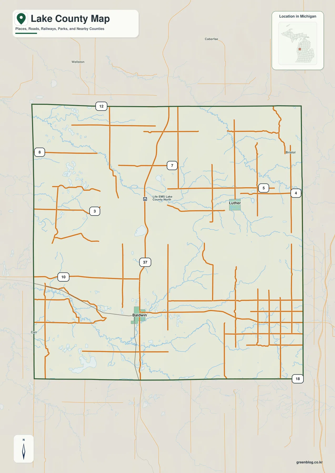
The map also contains many pale blue streams, but the road layer is the better first step for navigation. Locate Baldwin, follow M-37 north, and then trace US-10 west and east before moving into the smaller numbered roads. This approach gives the county a practical frame without requiring every local road number to be memorized. The map is useful for regional orientation, but it is not a substitute for a live routing service when driving time, road closures, or turn-by-turn directions matter.
Baldwin and Luther form a simple two-place settlement index
The city distribution map removes most of the road detail and emphasizes two ranked places: Baldwin and Luther. Baldwin is marked in the south-central portion of the county, while Luther is separated from it to the northeast. The layout makes the county’s settlement pattern look very different from a metropolitan county with many overlapping population centers. Instead of a broad urban belt, the map shows two small focal points surrounded by a large amount of lightly settled land.
That simplified city index should not be mistaken for a complete list of every Lake County community. The Library of Michigan also identifies places such as Idlewild, Chase, and Branch in its county guide. The value of the city map is its clarity: it shows where the two emphasized places sit relative to the county boundary and the water network. When paired with the general map, Baldwin can be recognized as the highway-centered southern reference point, while Luther helps orient the eastern and northeastern part of the county.
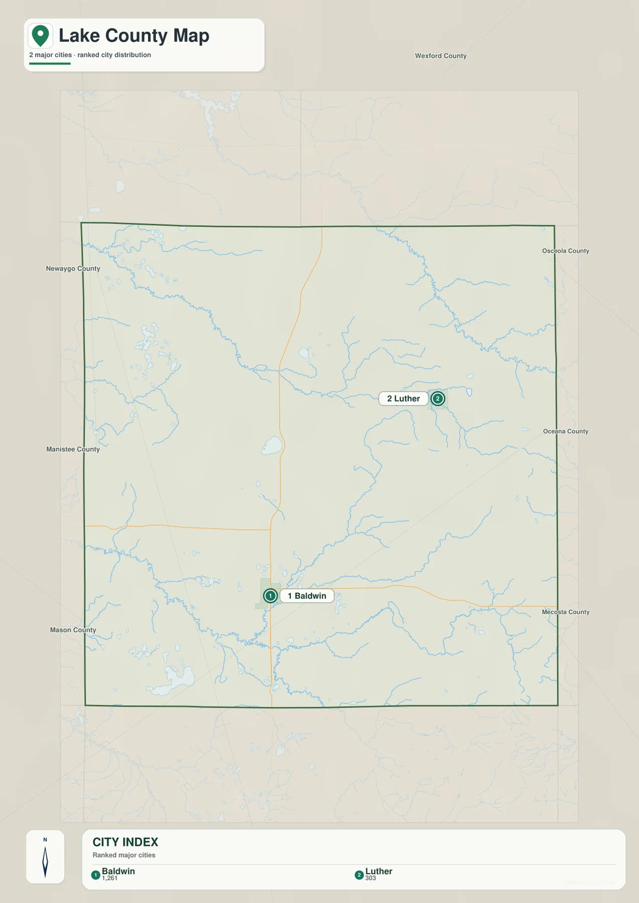
There are no route lines or driving-distance labels connecting the two places on this sheet. For that reason, it should be used to compare location rather than to calculate travel. Move back to the county map when you need roads, and use the city distribution map when you want a clean view of settlement spacing. Switching between the two also makes it easier to understand why rivers and lakes occupy so much of the visual space outside Baldwin and Luther.
Three river systems divide the county into distinct water landscapes
The terrain and water map reveals a more complicated structure than the road map. In the northwest, Stronach River and Harer Lake appear near the county edge, with Big Bass Lake and Seaman Lake farther south. The Little Manistee River is the most prominent watercourse across the northern part of the county and passes near the Cranberry Lake area before continuing westward. In the northeast, Pine River follows a separate course, showing that the northern half of Lake County is not drained by one single trunk river.
South of that divide, the pattern changes again. Baldwin River runs through the south-central area and connects into the larger Pere Marquette system. The Pere Marquette River is labeled in the southwest, while the Middle Branch Pere Marquette River appears toward the southeast. This separation is useful because it gives the Baldwin area a different hydrologic context from the Little Manistee corridor to the north and the Pine River country to the northeast. A reader can therefore use the map to divide the county into several water regions rather than treating it as one basin.
The lakes add another layer of local detail. Wolf Lake is near the center, while Cecilia Lake and Big Star Lake sit in the southwest. Big Bass Lake and Seaman Lake are farther northwest, and Cranberry Lake lies closer to the northern interior. These are location references, not statements about recreational access, depth, shoreline ownership, or flood safety. The map does not contain the information needed to decide whether a lake is publicly accessible or suitable for boating, and it should not be used as a floodplain or navigation chart.
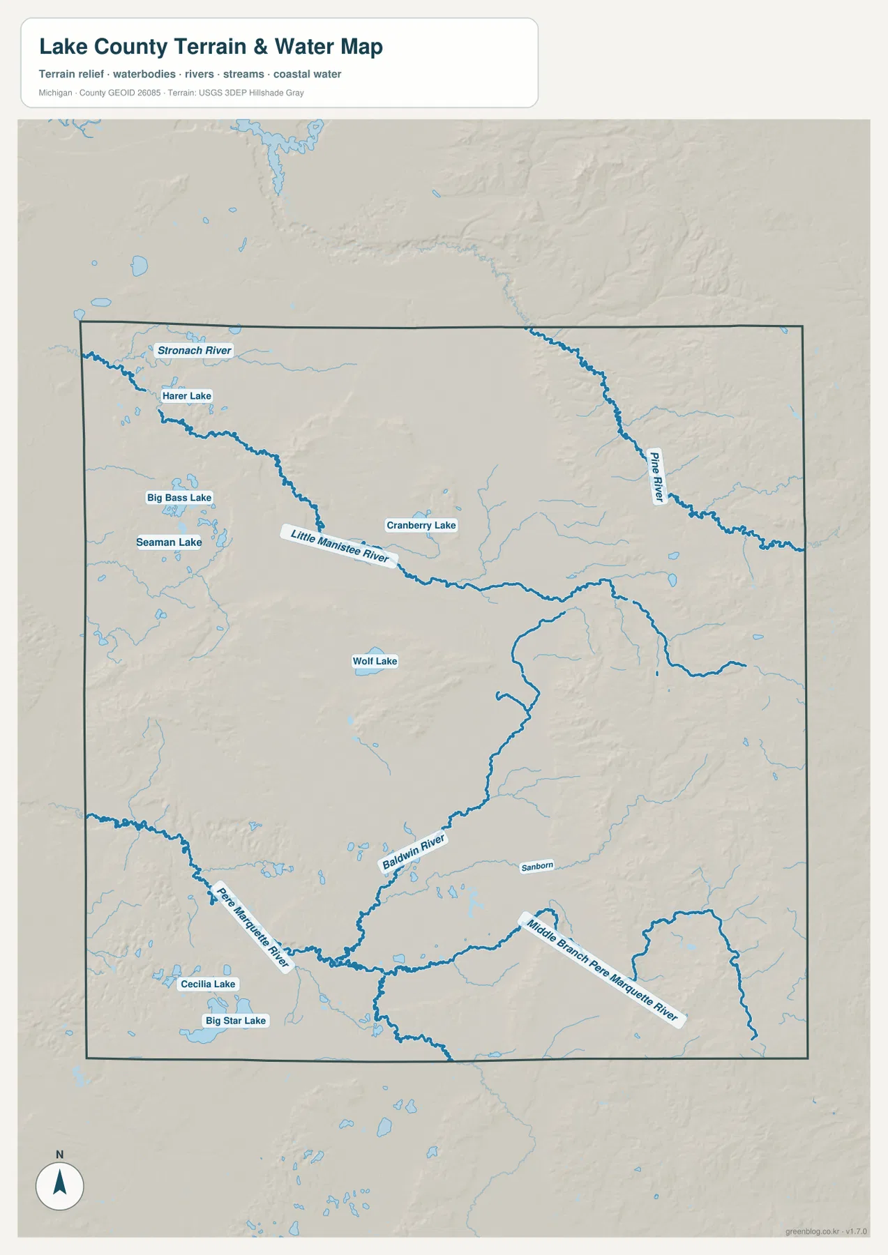
Comparing the three river systems also corrects the impression that all water simply runs in the same direction. The Little Manistee occupies the north and northwest, Pine River defines much of the northeastern drainage, and the Pere Marquette network serves the southern part of the county. Smaller tributaries branch through forested terrain between them. The result is a county divided by multiple drainage areas, which becomes even clearer when the water sheet is placed beside the elevation map.
Elevation rises from broad western lowlands toward the east and northeast
The elevation map removes almost all road and place labels so that relief becomes the subject. Its legend gives an actual range of about 203 to 428 meters, with a mean near 293 meters. Green tones cover much of the western and southwestern side of the county, indicating generally lower terrain. Yellow, tan, and brown colors become more extensive toward the eastern and northeastern side, where the shaded surface shows a denser pattern of ridges and valleys.
The western half is not uniformly flat. Several isolated higher areas rise above surrounding lower ground in the northwest and west-central sections. Likewise, the higher eastern side is not one continuous mountain wall; it is broken into ridges, valleys, and lower corridors. This matters when the elevation layer is compared with the water map. Pine River and many tributaries occupy lower corridors between higher ground, while the Pere Marquette system follows lower terrain in the south. The maps therefore complement each other: one identifies named water features, and the other explains the broader shape of the land around them.
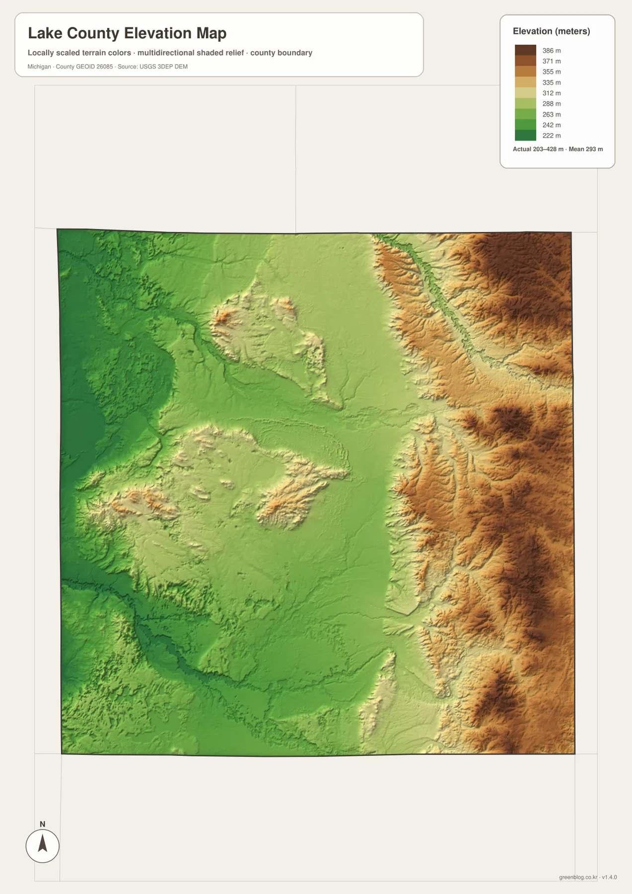
This elevation surface is intended for county-scale comparison, not precise site measurement. It can show whether a place lies in a broadly lower or higher part of Lake County, but it should not be treated as a survey for building, drainage engineering, grading, or property-level design. For those uses, the original elevation data and site-specific measurements are required. For classroom work, regional planning context, or a geographic introduction, however, the map is effective because the contrast between western lowlands and eastern uplands is immediately visible.
Reading roads, water, and relief in sequence makes the county easier to understand
A useful way to work through the maps is to begin with the road map and then add one layer at a time. First find Baldwin and the M-37/US-10 crossing. Next locate Luther on the city distribution sheet. Then move to the terrain and water map to identify the Little Manistee River in the north, Pine River in the northeast, and the Pere Marquette system in the south. Finally, open the elevation map and compare those water corridors with the lower and higher terrain. The sequence turns four separate graphics into one coherent picture of Lake County.
Baldwin is especially useful as a cross-map reference. It is the county-seat community on the general map, the first ranked place on the city index, and a convenient starting point for finding Baldwin River and the southern Pere Marquette network. Luther provides a second reference in the east, close to the Pine River side of the county. Once those two places are fixed in mind, the many small streams and lakes no longer feel randomly scattered, because they can be related to a known settlement, a highway corridor, or a larger river system.
For printing or close inspection, use the 3638 × 2572 pixel JPG files in the downloadable archive rather than relying only on the WebP images embedded in the article. They are useful for classroom handouts, regional reference sheets, general trip preparation, and presentations. The boundaries, hydrography, and elevation are still generalized map layers, so they should not replace legal parcel records, flood regulatory products, marine navigation information, or professional surveys. Choosing the one map that answers the main question and using the others as supporting context usually produces the clearest result.
Frequently Asked Questions
What is the easiest way to compare Baldwin and Luther on these maps?
Start with the city distribution map to see their relative positions, then return to the general county map for roads. Baldwin is in the south-central part of Lake County at the M-37 and US-10 crossing, while Luther lies farther northeast. The city sheet keeps the comparison simple, and the county map adds the road network needed for practical orientation.
Do the Little Manistee, Pine, and Pere Marquette rivers all drain the same part of Lake County?
No. The supplied water map places the Little Manistee River across the northern and northwestern area, Pine River in the northeast, and the Pere Marquette system in the southern portion of the county. They occupy different drainage areas and connect to different networks of tributaries, so Lake County should not be read as one single river basin.
Can the 203–428 meter elevation range be used as survey data for a property?
No. The elevation map is a generalized county-scale surface designed to compare broad high and low areas. It is useful for seeing the lower western terrain and higher eastern relief, but property design, construction, drainage calculations, and grading require official source data and site-specific surveying rather than this reference map.
Sources and Reference Information
- Lake County, Michigan official website: county government and Baldwin administrative information.
- Library of Michigan – Lake County Guide: county naming history, townships, and communities.
- U.S. Census Bureau TIGER/Line Shapefiles: boundary and road reference.
- USGS National Hydrography: river, lake, and stream reference.
- USGS 3D Elevation Program: elevation-data reference.
Map File Information
The ZIP contains the original high-resolution JPG files for the county map, city distribution map, terrain and water map, and elevation map. They are larger than the WebP images used in the article and are better suited to close viewing and printing.
- Included Files: Use only the versions confirmed in the article and supplied images
- File Type: Use the confirmed download contents
- Intended Use: Printing, education, presentations, and map-based projects
Related Maps
Green Map creates custom-edited map images using open geographic data sources such as geoBoundaries, Natural Earth, OpenStreetMap, and government open data. These maps are edited visual materials, not raw data files, and are provided for education, documents, presentations, and graphic reference.