Bay County occupies a long stretch of Michigan’s lower eastern side beside Saginaw Bay, with Bay City concentrated in the southeast and Pinconning much farther north. Essexville sits immediately east of Bay City, Auburn lies to the west, and the county widens into a more rural northern and western interior. I-75/US-23 and M-13 provide the strongest north-south references, while M-25 and M-84 help explain the east-west pattern around Bay City.
This page separates the county into a road-and-place view, a Bay City connection view, a terrain-and-water view, and an elevation view. High-resolution JPG originals of the supplied maps are available together in a ZIP download for printing, classroom materials, presentations, and detailed local reference. Looking across the maps makes it easier to connect the urban south, the northern Pinconning area, the river network, and the low Saginaw Bay shoreline.
The county’s shape is part of the story. Bay City sits near the broad southern section, while the eastern shoreline narrows northward before the boundary expands west again in the far north. A dense pattern of small streams crosses the inland side, and the elevation surface rises gradually away from the bay before reaching its highest colors in the northwest.
Table of Contents
I-75, US-23, and M-13 link Bay City with Pinconning
The general county map makes the central I-75/US-23 corridor the easiest north-south reference. It runs north from the Bay City area toward Pinconning and provides a direct visual link between the county’s urban south and its much more rural northern half. M-13 follows a separate route farther east, staying closer to communities and low terrain along the Saginaw Bay side.
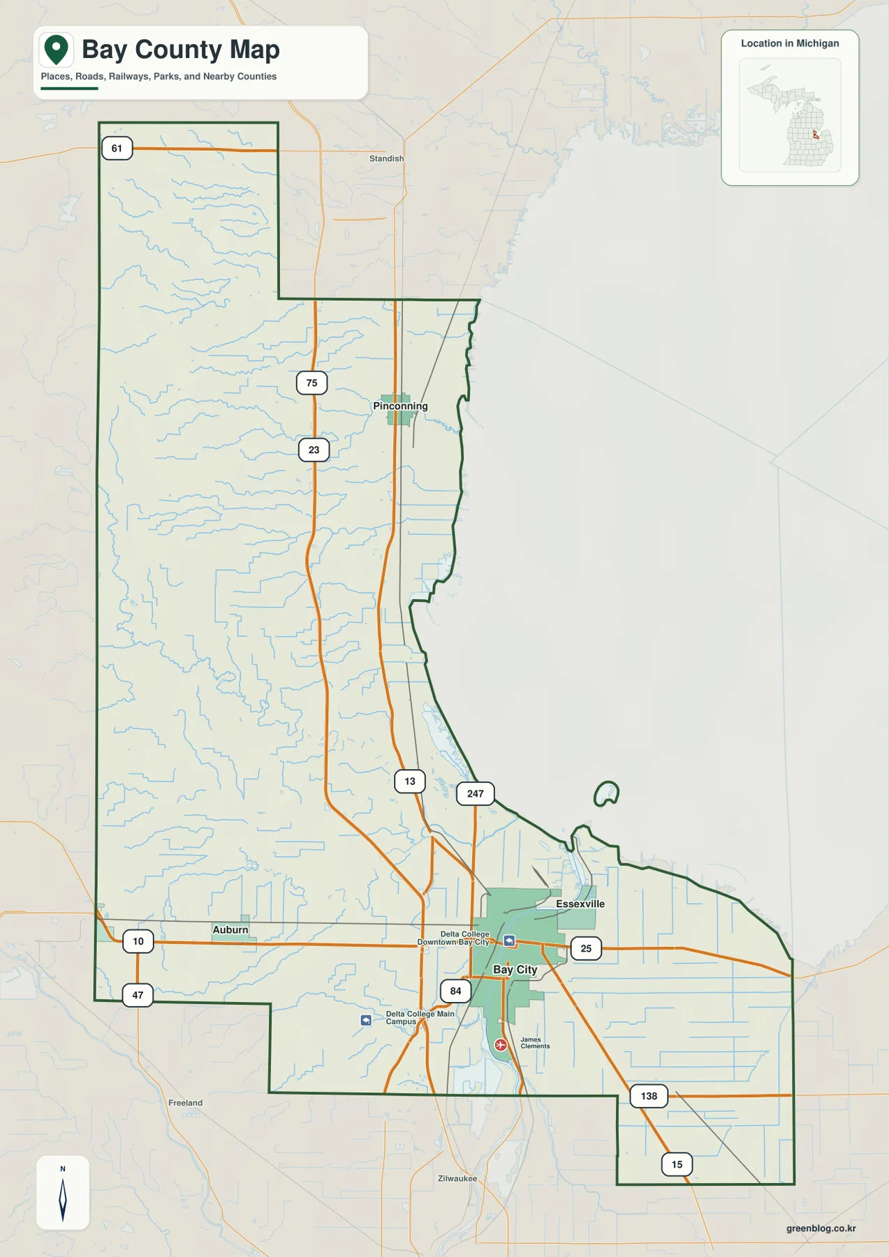
Several routes meet around Bay City. M-25 heads east along the southern side of Saginaw Bay, while M-84 reaches west toward Auburn. M-47 appears in the southwest, and M-15 and M-138 provide additional orientation near the southeastern edge. Together these roads show how Bay County connects with neighboring Saginaw, Midland, and Tuscola areas as well as with its own northern communities.
Auburn has a distinct inland position west of Bay City. M-84 makes the connection easy to identify, but the road grid around Auburn is much less dense than the urban network near the river and downtown Bay City. Essexville creates the opposite impression because it lies immediately east of Bay City, where streets, developed land, and the Saginaw River estuary are tightly packed together.
Pinconning is the main northern reference on the map. Its position between the I-75/US-23 corridor and M-13 makes it easy to locate, and its distance from Bay City illustrates how long Bay County is from south to north. Farther north, the county expands westward and the road pattern becomes more rural, with many small waterways crossing the interior.
Labels such as Delta College Downtown Bay City, Delta College Main Campus, and McLaren Bay Region provide additional orientation around the southern urban area. This map is intended for regional reference rather than live navigation. Current traffic, construction, closures, and seasonal conditions should be checked with up-to-date Michigan transportation or navigation services.
Bay City as the hub for Essexville, Auburn, and Pinconning
The connection map simplifies the county and uses Bay City as the hub. Essexville is marked immediately to the east, Auburn to the west, and Pinconning far to the north. Removing most local road detail makes the differences in direction and straight-line distance much easier to compare than they are on the general map.
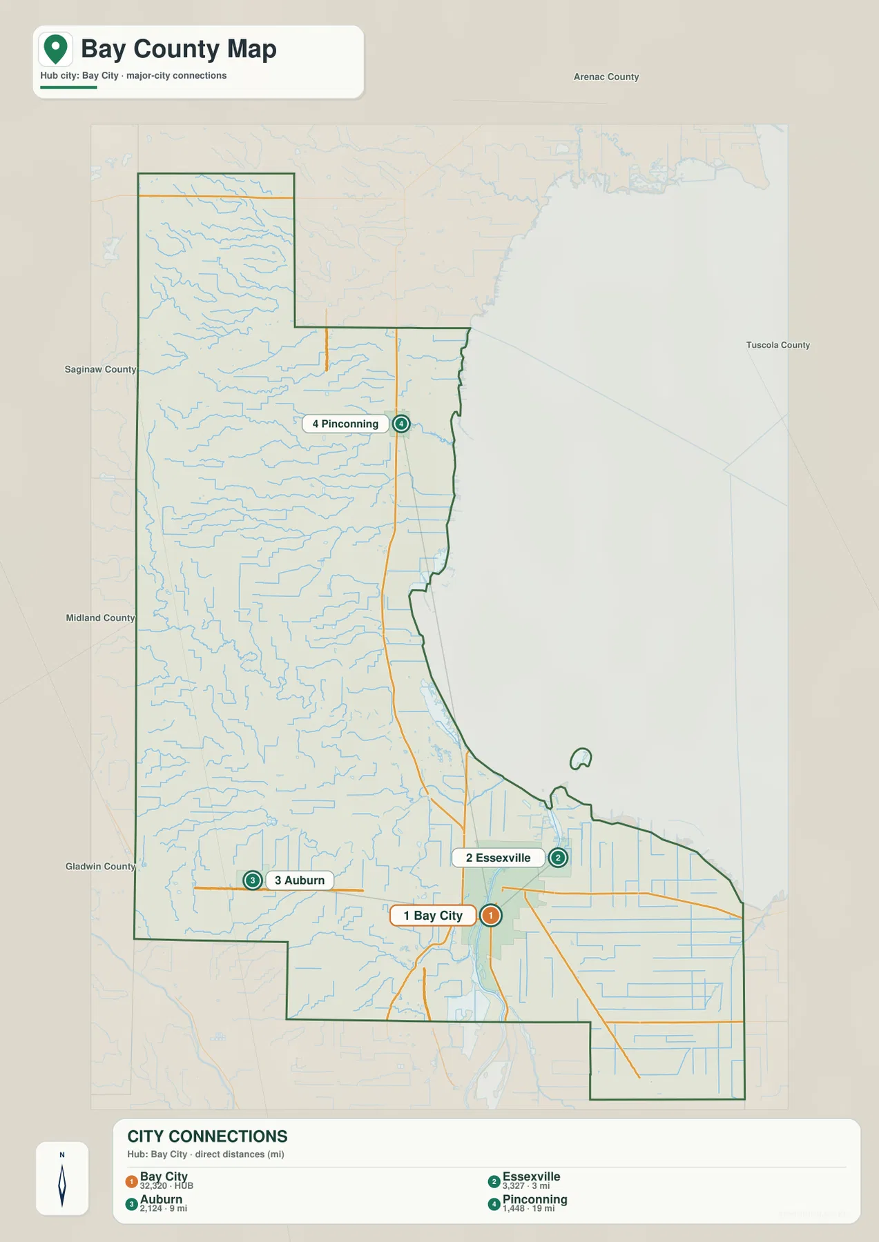
The CITY CONNECTIONS panel lists reference values of 32,320 for Bay City, 3,327 and 3 miles for Essexville, 2,124 and 9 miles for Auburn, and 1,448 and 19 miles for Pinconning. These numbers are useful for understanding the map’s ranking and hub-distance design, but they should not be treated as the latest official population figures. Current population data should be checked in the relevant U.S. Census Bureau release.
Essexville is the closest highlighted place to Bay City. The general map shows why: the two communities sit beside the same lower Saginaw River and Saginaw Bay urban area, with little geographic separation between their street networks. The short connection line on the simplified map is therefore a good representation of their close regional relationship.
Auburn is farther west and belongs to a more open inland setting. Pinconning is much farther north, giving the longest of the three highlighted hub connections. Comparing those directions makes clear that Bay County is not simply a compact Bay City metro area; it also includes a substantial western interior and a long northern section along the bay.
This map is not a complete community inventory. It omits smaller places and local roads so the selected hub relationships remain easy to read. Use the general county map when exact road corridors and additional labels matter, and use the connection map when a presentation or classroom explanation needs a quick sense of distance and direction from Bay City.
Saginaw River, Kawkawlin River, and Pinconning River drain toward Saginaw Bay
The terrain-and-water map shifts attention to the river network and the broad Saginaw Bay shoreline. Saginaw River is the largest visible channel, passing through Bay City before opening toward the bay. North and west of the city, the Kawkawlin River system gathers water from a broad inland area, while Pinconning River drains the northern part of the county toward the eastern shore.
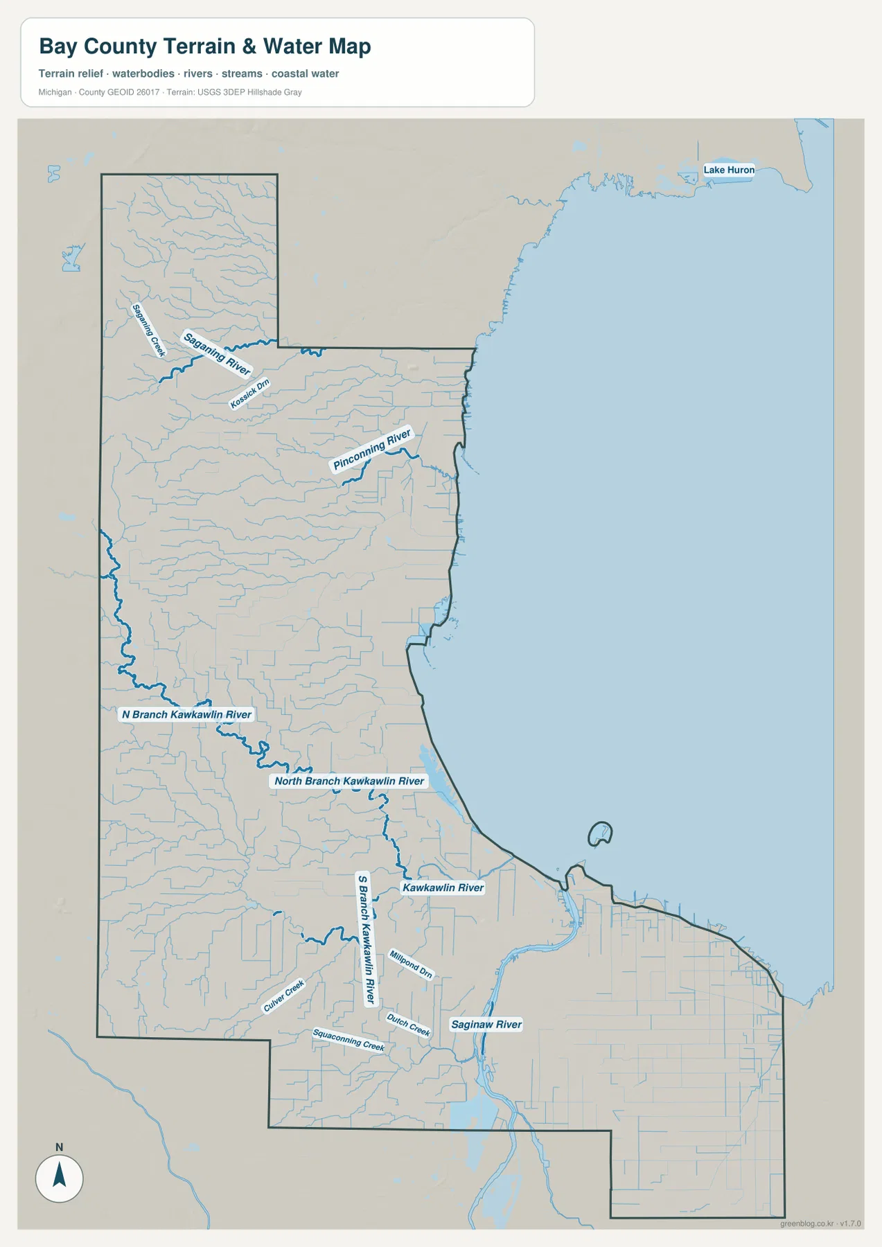
Kawkawlin River is fed by several named branches. North Branch Kawkawlin River and South Branch Kawkawlin River extend across the inland side, and many smaller channels join them before the system reaches the bay. The map also shows a dense network of straight drainage channels mixed with natural streams, which is especially noticeable across the broad, low agricultural areas west and north of Bay City.
Pinconning River occupies a separate northern drainage area and reaches the bay near the Pinconning side of the county. Smaller streams also cross the far northern extension, including Saganing Creek and numerous unnamed tributaries. The northern landscape therefore contains a much denser water network than a simple road map might suggest.
Saginaw River is different in scale. It enters the southern part of the county as a broad river, passes through the Bay City urban area, and continues toward the bay through very low terrain. Smaller creeks and drainage channels connect to the river along the way. The same low corridor appears as dark green on the elevation map, reinforcing the relationship between the river and the surrounding coastal plain.
This water map is a geographic reference, not a flood or navigation chart. It does not provide water depth, current speed, water quality, flood zones, legal access, or boating restrictions. Fishing, boating, drainage planning, and flood decisions should use current Michigan and federal information in addition to this county-scale view.
Low Saginaw Bay terrain rises toward the northwest
The elevation map removes most roads and labels and uses a locally scaled color ramp with shaded relief. Its legend reports an actual range of about 171 to 255 meters and a mean of 189 meters. Dark green represents the lower parts of Bay County, lighter greens and yellows mark intermediate ground, and brown identifies the highest terrain. The colors are scaled locally, so identical shades on another county map should not be assumed to represent the same elevation.
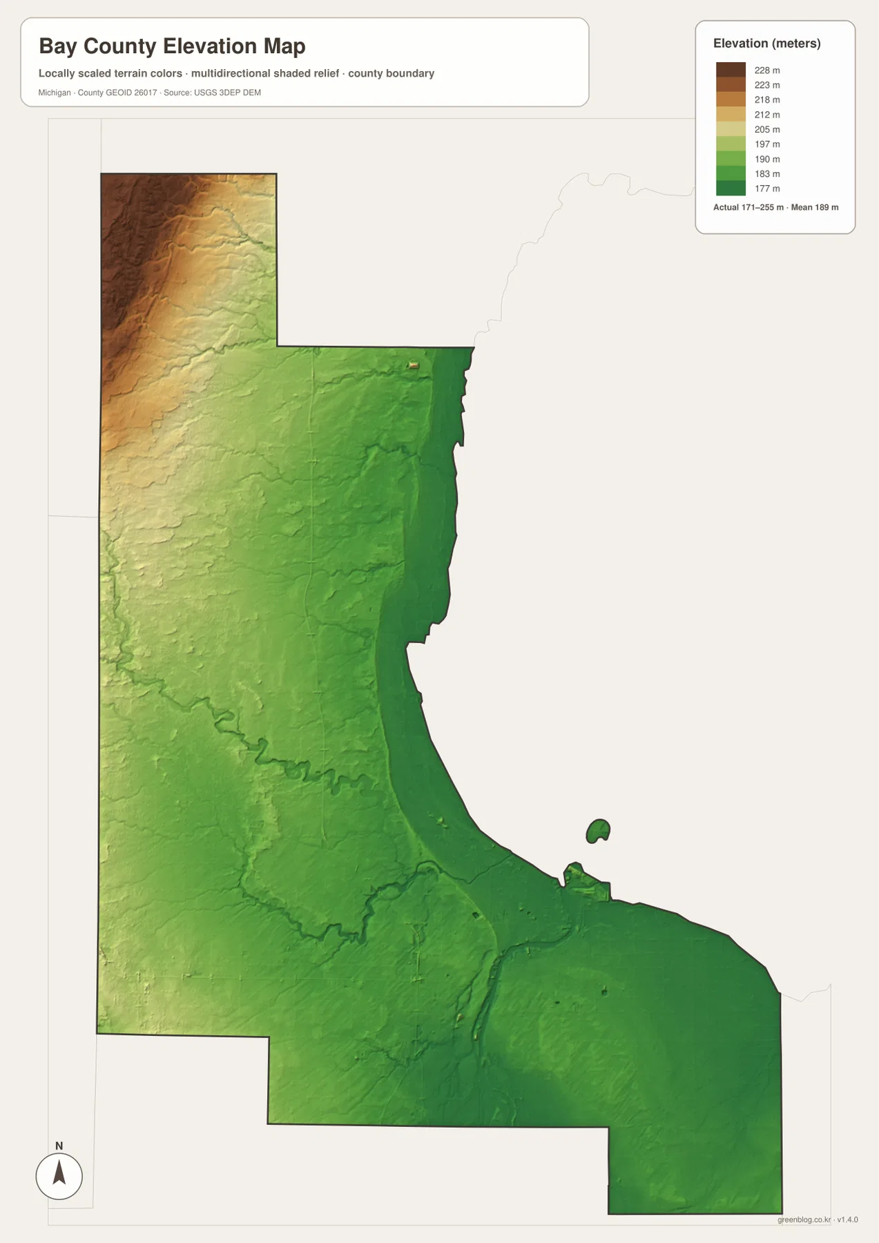
The darkest green terrain follows much of the Saginaw Bay shoreline and the Bay City area. The lower Saginaw River corridor is also visible as a broad low feature extending inland from the bay. These areas have very little relief compared with the northwest, and the water map’s dense drainage network fits closely with the low elevation surface.
Moving west from the shoreline, colors become lighter and then warmer. The far northwestern extension contains the broadest brown area and the strongest relief shading, showing a clear rise above the coastal plain. Small valleys cut through that higher ground, but the overall pattern is unmistakable: elevation increases away from Saginaw Bay and reaches its highest values in the northwest.
The Pinconning area occupies a transition between those two settings. Ground near the bay remains low, while the western side rises gradually. Pinconning River and nearby tributaries follow lower channels through that transition. The Kawkawlin River system shows a similar pattern farther south as water moves from slightly higher inland terrain toward the lower bay side.
Southern Bay County remains predominantly green, but it is not perfectly flat. The Saginaw River valley, agricultural drainage channels, and small low areas produce subtle relief differences that are easier to see in shaded terrain than on the road map. Those small differences matter most for understanding water movement rather than for recognizing dramatic hills.
This elevation surface is a generalized county-scale reference and should not be used as survey data. Exact parcel elevations, engineering slopes, drainage design, construction planning, and other precision work require authoritative detailed sources such as the USGS 3D Elevation Program rather than estimates from the map colors.
Comparing Bay City, Pinconning, Auburn, and the bay shoreline across the maps
Bay City is the easiest place to compare across all four views. The general map shows it at a road junction for I-75/US-23, M-13, M-25, and M-84. The connection map uses it as the hub for Essexville, Auburn, and Pinconning. The water map places it on the Saginaw River close to the bay, and the elevation map shows that the urban area lies on some of the county’s lowest ground.
Pinconning has a different geographic setting. It is a separate northern community on the general map and the farthest highlighted connection from Bay City. Pinconning River drains toward the nearby shoreline, while the elevation surface rises progressively to the west. That combination makes the north a transition between low coastal terrain and the higher northwestern interior.
Auburn represents the western inland side. M-84 connects it to Bay City, but its surroundings are more open and less urban. Small streams remain common, and elevation begins to increase toward the west. It sits well below the highest northwestern terrain, yet it is clearly removed from the lowest Saginaw River and bay-side ground.
Essexville is almost the opposite. It is only a short distance from Bay City and lies close to the Saginaw River estuary and bay-side lowlands. The connection map emphasizes its proximity to the hub, while the water and elevation views explain why the area has so much low, water-adjacent terrain.
The four views therefore answer different questions without duplicating one another. Use the general map for roads and named places, the connection map for direction and hub distance, the water map for rivers and drainage channels, and the elevation map for the transition from the low Saginaw Bay plain to higher inland ground.
Choosing a Bay County map and using the downloadable files
Start with the general county map when you need roads and place names. Bay City, Essexville, Auburn, Pinconning, I-75/US-23, M-13, M-25, and M-84 can all be compared in one frame. It is useful for orientation, but current travel times, construction, closures, and traffic conditions should come from live transportation or navigation services.
Use the connection map when the main question is how Bay City relates to Essexville, Auburn, and Pinconning. Choose the terrain-and-water map for the Saginaw, Kawkawlin, and Pinconning river systems and the Saginaw Bay shoreline. The elevation map is the clearest option for comparing the low coastal plain with the higher western and northwestern interior.
The WebP images on this page are optimized for browser viewing. The ZIP below contains the original high-resolution JPG versions of the general county map, community-connection map, terrain-and-water map, and elevation map. Those files are better suited to printing, classroom handouts, presentations, and large displays where additional image detail is useful.
Frequently Asked Questions
Which map is best for finding Bay City, Pinconning, and Auburn together?
Use the general county map. It shows Bay City with I-75/US-23, M-13, and M-84, making it easy to compare Pinconning to the north and Auburn to the west. The connection map is also useful when you only need the approximate straight-line direction and spacing from Bay City.
Which map shows the Saginaw and Kawkawlin river systems?
Use the terrain-and-water map. It shows Saginaw River, Kawkawlin River, North Branch and South Branch Kawkawlin River, Pinconning River, and the Saginaw Bay shoreline. It is a location reference and does not provide flood, depth, water-quality, navigation, or access information.
Where does Bay County appear highest on the elevation map?
The lowest dark-green terrain lies around Bay City, the Saginaw River, and the Saginaw Bay shoreline. Elevation rises toward the west and becomes highest in the northwestern extension, where yellow and brown colors are most widespread. The legend reports an actual range of roughly 171 to 255 meters.
Map File Information
The ZIP contains the high-resolution JPG originals for the Bay County general map, community-connection map, terrain-and-water map, and elevation map described on this page.
- Included Files: general county map, community-connection map, terrain-and-water map, elevation map
- File Type: JPG
Related Maps
Sources and reference links
For county government and local information, see the official Bay County website. For the underlying types of boundary, hydrography, and elevation information used in county mapping, consult U.S. Census Bureau TIGER/Line, USGS National Hydrography, and the USGS 3D Elevation Program. These page maps are general reference products and do not replace legal boundaries, survey data, navigation charts, or flood determinations.
Green Map creates custom-edited map images using open geographic data sources such as geoBoundaries, Natural Earth, OpenStreetMap, and government open data. These maps are edited visual materials, not raw data files, and are provided for education, documents, presentations, and graphic reference.