Suffolk County sits on the Massachusetts coast and is organized around Boston, with Chelsea, Revere, and Winthrop clustered close to the harbor and outer shoreline. The county looks compact on a statewide map, yet its local outline is unusually intricate because broad urban areas, narrow waterfront strips, inlets, river mouths, and offshore islands all meet within a short distance. Reading the county as a single block can therefore be misleading. The supplied maps are most useful when Boston is treated as the main reference point and the smaller northeastern municipalities are compared against the surrounding water.
This page provides three map views: a general county map with boundaries and place labels, a city-connections map centered on Boston, and a terrain-and-water reference map showing major rivers, basins, creeks, inlets, and coastal water. The same three map products are available as high-resolution JPG files in the downloadable ZIP. They work well for orientation, classroom material, presentations, and printed reference sheets, but they are not substitutes for live traffic maps, parcel records, flood-hazard products, navigation charts, or engineering surveys.
Table of Contents
A broad Boston section beside the compact Chelsea–Revere–Winthrop coast
The general map makes the county’s uneven shape immediately clear. Boston occupies the large southern and western portion, extending well inland before turning back toward the harbor. Chelsea and Revere form much smaller pieces to the northeast, while Winthrop Town projects toward the water east of them. Because these areas are close together, the county can look like one continuous urban district at first glance, but the green boundary shows several narrow connections, sharp turns, and waterfront edges that separate one municipality from another.
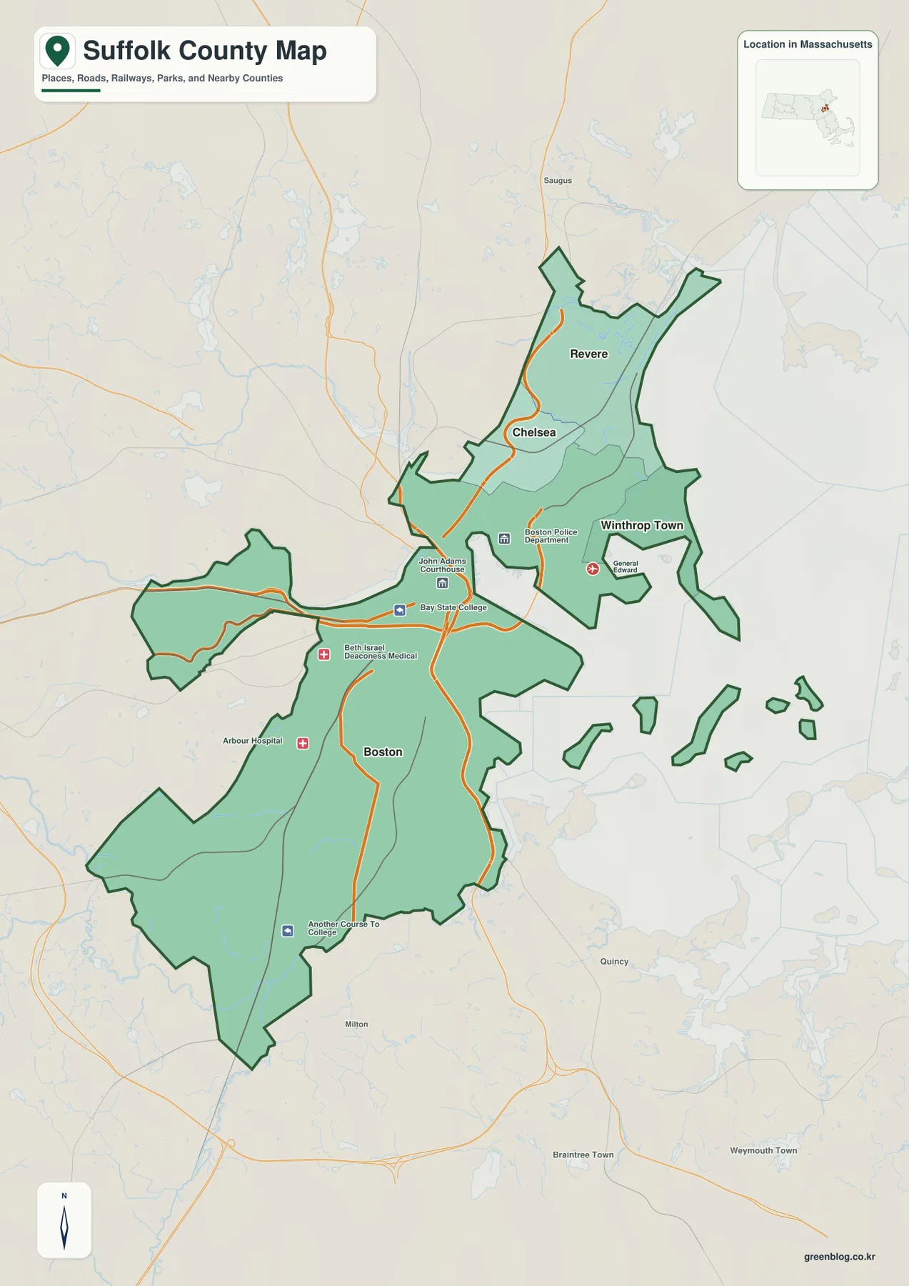
Revere appears at the northern end of the county’s northeastern cluster. Chelsea sits immediately to its southwest, and Winthrop is positioned to the east and southeast near the water. The map also includes nearby names such as Saugus, Quincy, and Milton outside the county boundary. Those surrounding labels are useful for orientation, but they should not be mistaken for communities inside Suffolk County. The dark county outline remains the best guide whenever a place name is close to the edge.
Boston’s portion of the county has a very different form. The main area is broad, but long western and southern extensions create a boundary that is far from rectangular. The map also shows water separating parts of the eastern shoreline and several small island shapes offshore. These details matter because a simple city list cannot show how much of Suffolk County’s geography is controlled by coastline and water. A reader looking only at the names Boston, Chelsea, Revere, and Winthrop could easily underestimate how fragmented the shoreline appears on a county map.
The small inset locating Suffolk County within Massachusetts provides another useful scale. It places the county on the state’s eastern coast, in the Boston area, rather than showing it as an isolated administrative unit. That statewide context is helpful when the map is used in school material or a presentation where the audience may know Massachusetts but not the individual county boundaries. Once the statewide location is clear, the main map can be used to explain the much more detailed relationship between Boston and the three northeastern municipalities.
A few civic and institutional points are visible on the general map, including courthouse, hospital, and public-safety labels. They are best treated as orientation landmarks rather than a complete directory. In a dense urban county, plotting every facility would obscure the boundary and shoreline that the map is intended to emphasize. For most county-level uses, the more important sequence is to identify Boston, trace the green boundary, locate Chelsea and Revere to the north, then move east to Winthrop and the surrounding water.
The county’s neighbors also help explain its form. Areas labeled Middlesex County, Norfolk County, and Plymouth County appear around the main Suffolk outline, showing how closely this county is embedded in the larger Boston metropolitan region. There is no wide rural buffer between the central city and the county edge. Instead, administrative lines run through a continuous urban landscape and meet water at several points. That is why the boundary should be read together with neighboring place names rather than as a self-contained shape.
For a first look at Suffolk County, this general map is the strongest starting point. It combines enough place labels to establish orientation without reducing the map to a city-only diagram. Boston provides the main anchor; Chelsea and Revere define the northern cluster; Winthrop shows the eastern coastal extension; and the offshore pieces emphasize the role of harbor geography. When the goal changes from boundary context to city-to-city comparison, the next map removes much of this detail and gives the four municipalities a simpler visual hierarchy.
Boston as the hub for nearby Revere, Chelsea, and Winthrop
The city-connections map strips away many secondary labels and uses Boston as the hub. Boston is marked as number 1, Revere as number 2, Chelsea as number 3, and Winthrop Town as number 4. This simplified design makes one of Suffolk County’s defining characteristics easy to see: the principal municipalities are not spread across a vast territory. They are concentrated within a tight coastal urban area, with Boston occupying the large southern section and the other three grouped to the northeast.
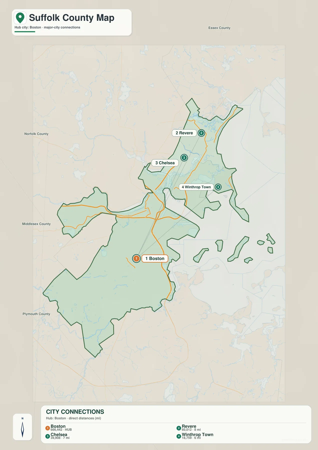
The CITY CONNECTIONS panel lists Revere at about 8 miles from Boston, Chelsea at about 7 miles, and Winthrop Town at about 6 miles. These are straight-line distances between the mapped city reference points, not driving distances along streets, bridges, or tunnels. In Suffolk County that distinction is especially important because water interrupts the shortest geometric path in several places. A point that appears only a few miles away can require a longer road route around a river, inlet, or harbor edge.
Revere is the northernmost of the three non-hub places. On the general map its area stretches along the coast, while the connections map reduces it to a numbered point. That reduction is useful when the only question is relative direction from Boston. It is less useful when a reader needs to know the actual municipal boundary, the shape of the shoreline, or which nearby places lie outside the county. For those questions, the general map should remain the companion reference.
Chelsea appears southwest of Revere and north of central Boston. Its compact position becomes much easier to recognize after the detailed background is removed. The map is particularly effective for explaining that Chelsea is not far from Boston geographically even though the surrounding water and infrastructure can make actual travel more complicated than the straight-line number suggests. The connection line is a visual comparison aid only; it is not a road, rail line, transit route, or recommended travel path.
Winthrop Town is plotted east of Boston and southeast of the Chelsea–Revere pair. On the general map, its peninsula-like setting and surrounding water are obvious. On the connections map, the same place becomes a single point only 6 miles from the Boston hub. Comparing the two views is useful because it shows how a short geometric distance can hide the practical effect of coastline and inlets. This is one reason the city map should be used for orientation rather than for travel-time estimates.
The numeric values printed beside the city names also include figures that resemble population counts from the dataset used to build the map. They should not be treated as a statement of the latest official population. Population estimates change with reference year and methodology, and current figures should be checked through the U.S. Census Bureau when they matter to a project. For this map, the geographic lesson is more durable: Boston is the hub, and the three other municipalities are clustered within a short straight-line radius on the northeastern side of the county.
This compact pattern distinguishes Suffolk County from many large counties where the leading towns are separated by long stretches of open land. Here, a small map area contains several municipal boundaries, a major city, dense development, rivers, inlets, and open coastal water. The city-connections view intentionally suppresses most of that complexity so the relative positions remain readable. It works best when paired with the general map for boundaries and with the terrain-and-water map for the physical features that complicate direct movement.
Charles River Basin, Chelsea River, Neponset River, and the surrounding coast
The terrain-and-water map changes the visual emphasis from municipalities to waterways and coastal form. Charles River Basin and Muddy River appear in the central-western part of the county, while Chelsea River, Island End River, and Mill Creek are labeled in the northeast. Neponset River traces a prominent southern waterway, and Stony Brook is visible farther inland. To the east, Broad Sound and Massachusetts Bay occupy a large share of the map, making clear how strongly coastal water shapes Suffolk County’s eastern edge.
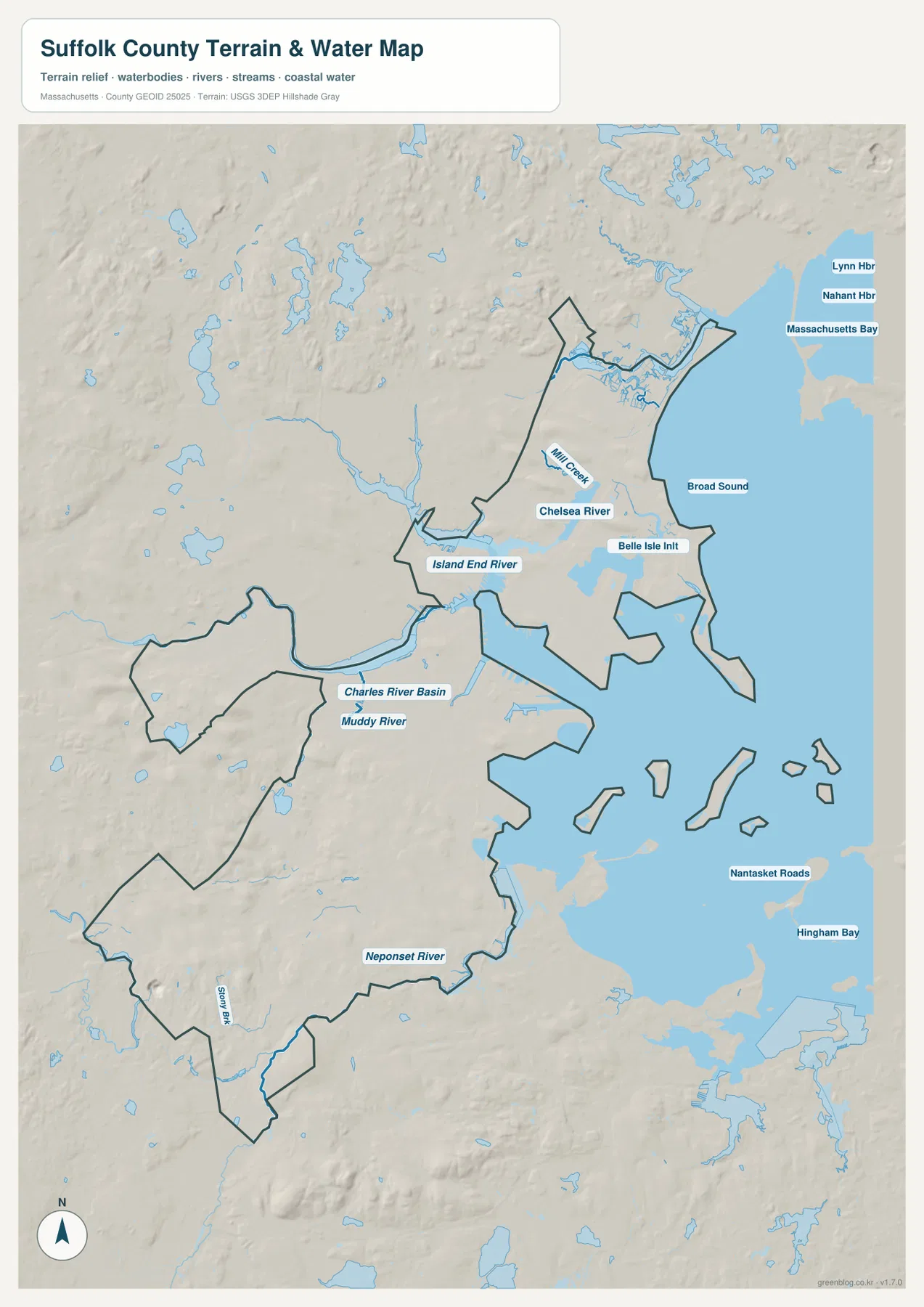
Charles River Basin is the clearest western water reference around central Boston. The broader basin reaches the county edge, while Muddy River appears just to the south. When this map is compared with the general county outline, it becomes easier to understand why the western and central boundary cannot be described as a simple straight line. Water and urban land meet repeatedly, and the county shape follows a much more irregular pattern than a grid-style administrative map might suggest.
The northeastern group of waterways is even more compact. Chelsea River lies close to Chelsea and the eastern Boston shoreline, Island End River enters from the west, Mill Creek is labeled farther north, and Belle Isle Inlet appears close to the coast. These features help explain the narrow land connections around Chelsea, Revere, and Winthrop. On the general map, those municipalities look tightly packed; on the water map, the reason for the many bends and constrictions becomes more apparent because several channels and inlets occupy the same small area.
Broad Sound lies east of the Revere–Winthrop side of the county and opens toward Massachusetts Bay. The background also labels Lynn Harbor and Nahant Harbor to the north and Nantasket Roads and Hingham Bay to the southeast. Those names provide regional coastal context rather than indicating that every labeled water body lies within Suffolk County. Readers should use the county boundary and the water labels together, especially when preparing a presentation that distinguishes the administrative county from the larger Boston-area coastline.
Neponset River is the strongest southern river reference on the map. It follows the lower side of Boston before reaching coastal water, while smaller streams and ponds appear inland. Comparing Neponset River with Charles River Basin and Chelsea River shows that Suffolk County’s water geography is not organized around a single river. Different parts of the county meet different basins, creeks, inlets, and harbor waters, which is one reason a water-focused map can reveal relationships that are easy to miss on a road-and-boundary view.
The shaded terrain background is useful for general relief, but it should not be interpreted as survey-grade elevation data. Coastal areas appear comparatively low and smooth, while inland parts show somewhat more variation. There are no contour lines or precise elevation labels on this product, so it cannot answer questions about the exact height or slope of a street, lot, building site, or engineering project. For accurate elevation measurements, the USGS 3D Elevation Program or another dedicated elevation dataset is the appropriate source.
The blue water areas also do not represent flood zones, depth, water quality, tidal range, or navigable channels. A wide blue river symbol is a cartographic reference, not a measurement of actual width at every point. The same caution applies to Broad Sound and Massachusetts Bay. Anyone evaluating flood exposure, marine navigation, or environmental conditions should use the current specialist product for that purpose. This map is designed to answer a simpler question: where are the named rivers, creeks, basins, inlets, and coastal waters in relation to the county?
Choosing the map for boundary context, city spacing, or waterways
Use the general county map when the main task is to introduce Suffolk County itself. It shows Boston’s large footprint, the compact Chelsea–Revere–Winthrop cluster, nearby communities, the county outline, and enough coastline to explain the basic shape. That combination makes it a practical choice for a report cover, classroom handout, or presentation slide where the audience first needs to understand where the county begins and ends.
Use the city-connections map when the question is narrower: where are Revere, Chelsea, and Winthrop relative to Boston, and how close are their mapped reference points? The 8-, 7-, and 6-mile labels make that comparison quick, as long as they are described correctly as straight-line distances. This view is intentionally simplified and should not be used to infer a driving route or travel time. For roads and detailed boundaries, return to a current transportation map or the general county map.
Use the terrain-and-water map when river and coastline relationships matter most. Charles River Basin, Chelsea River, Island End River, Neponset River, Broad Sound, and Massachusetts Bay provide a physical framework for understanding why the county boundary bends and narrows in so many places. The map is particularly helpful when a reader wants to see how close the northeastern municipalities are to inlets and open water rather than simply seeing them as points on an urban map.
Together, the three products give a more complete picture than any one of them alone. The general map establishes county form and place names, the city map simplifies the Boston-centered relationship among the four municipalities, and the water map explains the rivers and coast that shape those relationships. The web images are optimized for on-page viewing; for printing, cropping, or larger display, the downloadable ZIP contains the original high-resolution JPG versions of the same maps.
Frequently Asked Questions
Why does the city-connections map focus on Boston, Revere, Chelsea, and Winthrop?
The city map is designed to summarize the principal municipal relationship within Suffolk County rather than list every Boston neighborhood or nearby community. Massachusetts county references identify Boston, Chelsea, Revere, and Winthrop together within Suffolk County, and the map uses Boston as the hub so the direction and direct distance to the other three can be compared cleanly. A detailed city map is better for neighborhoods and local streets.
Are the 8 miles to Revere, 7 miles to Chelsea, and 6 miles to Winthrop driving distances?
No. They are straight-line distances between the Boston hub and the mapped reference points. Actual road distance can be longer because the county contains rivers, inlets, harbor water, bridges, tunnels, and a dense street network. Use a current navigation or transportation service when route length or travel time is important.
Can the water map be used for flood risk or marine navigation?
No. The terrain-and-water map is a geographic reference showing the relative location of rivers, creeks, basins, inlets, and coastal water. It does not show flood extents, water depth, tidal conditions, water quality, or navigation channels. Use current official flood products for hazard decisions and official nautical charts for navigation.
Map File Information
The ZIP contains the original high-resolution JPG files for the Suffolk County general map, the Boston-centered city-connections map, and the terrain-and-water reference map described on this page.
- Included Files: general county map, city-connections map, terrain-and-water reference map
- File Type: JPG
Related Maps
Sources and References
For current Suffolk County statistics, municipal jurisdiction, official boundary data, and hydrography, the following sources provide useful supporting information.
- U.S. Census Bureau – Suffolk County, Massachusetts QuickFacts
- Mass.gov – Suffolk County District Attorney’s Office
- U.S. Census Bureau TIGER/Line Shapefiles
- USGS National Hydrography
- U.S. National Park Service – Boston Harbor
Green Map creates custom-edited map images using open geographic data sources such as geoBoundaries, Natural Earth, OpenStreetMap, and government open data. These maps are edited visual materials, not raw data files, and are provided for education, documents, presentations, and graphic reference.