Middlesex County covers a wide cross-section of eastern Massachusetts. On the Boston side, Cambridge, Newton, Somerville, Malden, Medford, and Everett sit close together in the southeast. Farther west, Waltham, Framingham, and Marlborough create a different set of reference points, while Lowell stands well to the north near the Merrimack River. The county map makes that contrast especially clear: dense inner-suburban communities occupy only one end of a much larger county that reaches into less tightly settled northern and western areas. High-resolution map files are available for download in the section below.
This page provides three complementary map references: a general county map with major roads and selected communities, a ranked six-city distribution map, and a terrain-and-water map with rivers, ponds, and shaded relief. The original high-resolution JPG versions shown by these maps can be downloaded together in a ZIP file. They are useful for regional orientation, printing, classroom material, and presentations, but they are not substitutes for current traffic data, legal parcel boundaries, flood maps, navigation charts, or engineering-grade elevation products.
Table of Contents
Five labeled highways frame a county that reaches from Cambridge to Lowell and Marlborough
The general map is the best place to understand the county’s unusual range of settlement patterns. Cambridge, Newton, Waltham, Medford, Malden, Everett, and Melrose are concentrated near the southeastern edge, immediately outside or next to the Boston area. Woburn and Wilmington extend that urban sequence northward. Lowell is then highlighted as a large northern center, separated from the inner-suburban group by a broad middle section. In the southwest, Framingham and Marlborough form another recognizable pair well away from Cambridge and Lowell.
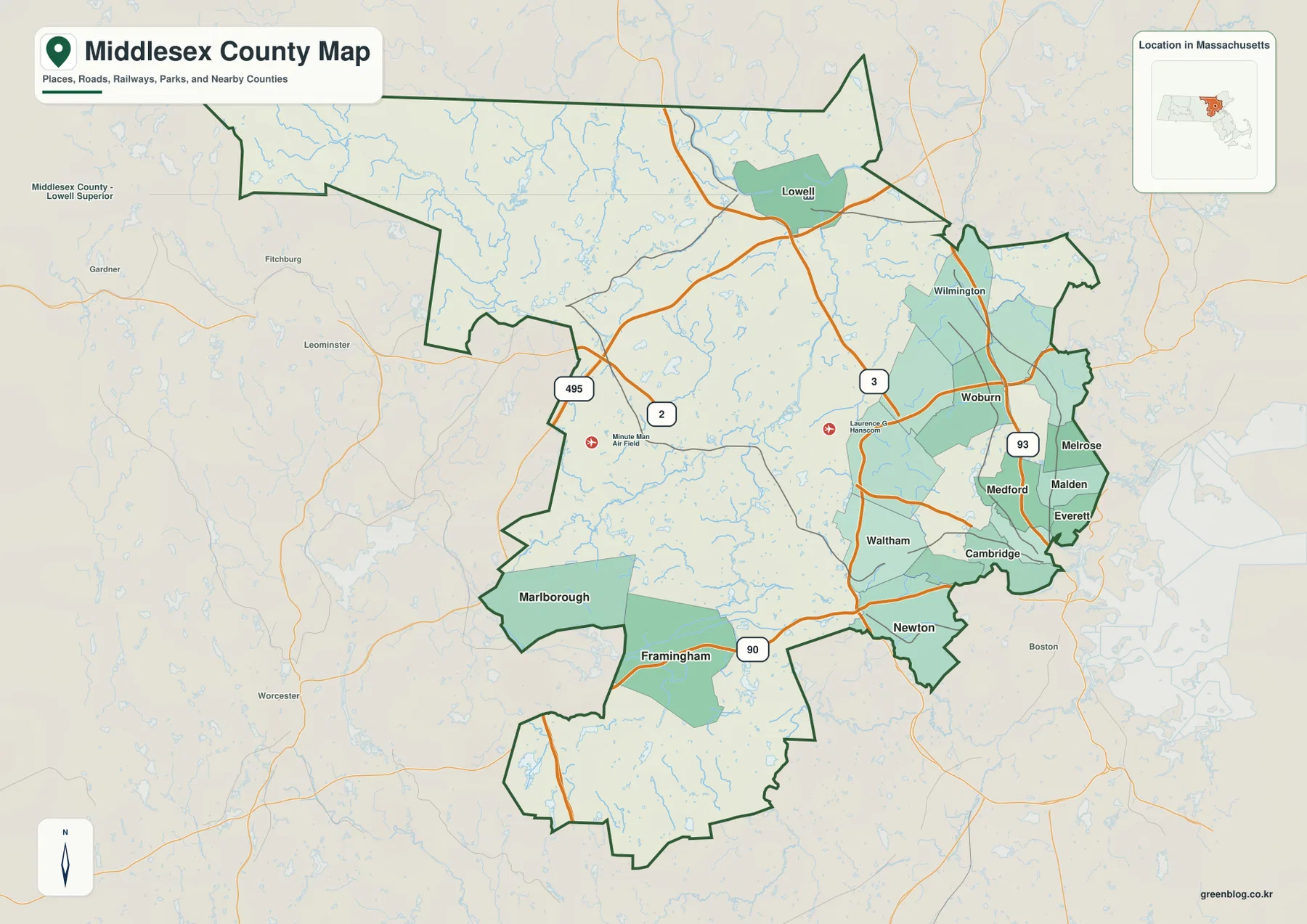
Route 2 and I-90 provide two different east-west references. Route 2 approaches the Cambridge side through the central part of the county, while I-90 runs farther south through the Framingham-Newton corridor. Because the two routes occupy different bands, they help separate the central and southern portions of Middlesex County rather than functioning as one combined corridor. A reader looking from Marlborough or Framingham toward the Boston side can use I-90 as the lower reference, while Route 2 is more useful for the middle of the county.
Route 3 and I-93 are the stronger north-south references in the eastern half. Route 3 comes down from the Lowell area and passes through the county’s central-eastern side. I-93 lies farther east, close to the cluster of communities north of Boston. On the map, that separation helps explain why the eastern side contains several parallel ways to orient between northern and southeastern communities. The lines should not be read as a current routing recommendation, but they make the county’s transportation geography much easier to organize.
I-495 is the most useful road for understanding the outer western and northwestern scale of the county. It appears near the Marlborough side, arcs through the less densely labeled interior, and continues toward the Lowell region. Compared with the Cambridge-Malden side, the land around the I-495 portion of the map has fewer large city labels and more open space between roads. That visual difference is important because Middlesex County is often associated with Boston’s suburbs, even though its western and northern sections occupy a very different map setting.
Lowell is visually distinct from the southeastern city cluster. It sits near the northern edge of the county and close to the Merrimack River, with Route 3 providing a clear road reference to the south. Wilmington and Woburn appear farther down that side of the map, bridging part of the space between Lowell and the inner suburbs. The city-and-water maps later in the article make the separation even clearer: Lowell belongs to a northern river setting, while Cambridge, Newton, Malden, and Somerville are much closer to the Boston side.
The southeastern edge is compact and complicated because several municipal labels fit into a small area. Cambridge and Newton are west of Boston, while Medford, Malden, Everett, and Melrose sit to the north and northeast. Waltham is farther inland. The county boundary bends around these communities and meets neighboring counties in a way that can be hard to follow on a small screen. This overview is therefore best for regional orientation; legal municipal limits, parcels, and property questions require an official boundary or assessor source.
A practical way to use the general map is to begin in the southeast, trace west toward Waltham and Framingham, then turn north toward Lowell. Doing that reveals how much territory lies between the best-known Boston-adjacent communities and the northern end of the county. The map is especially useful when road numbers and community names must be shown together. When the goal is simply to compare selected major cities, the next map removes most of that detail and makes the distribution pattern easier to see.
Six ranked cities reveal two different concentrations rather than a single county center
The city-distribution map reduces the county to six ranked locations: Cambridge is marked 1, Lowell 2, Newton 3, Somerville 4, Framingham 5, and Malden 6. The most striking feature is not the ranking itself but the geography of the dots. Cambridge, Newton, Somerville, and Malden form a tight southeastern group. Lowell is isolated far to the north, while Framingham occupies a separate southwestern position. That pattern makes clear that Middlesex County does not have one compact center from which all of its major cities spread outward.
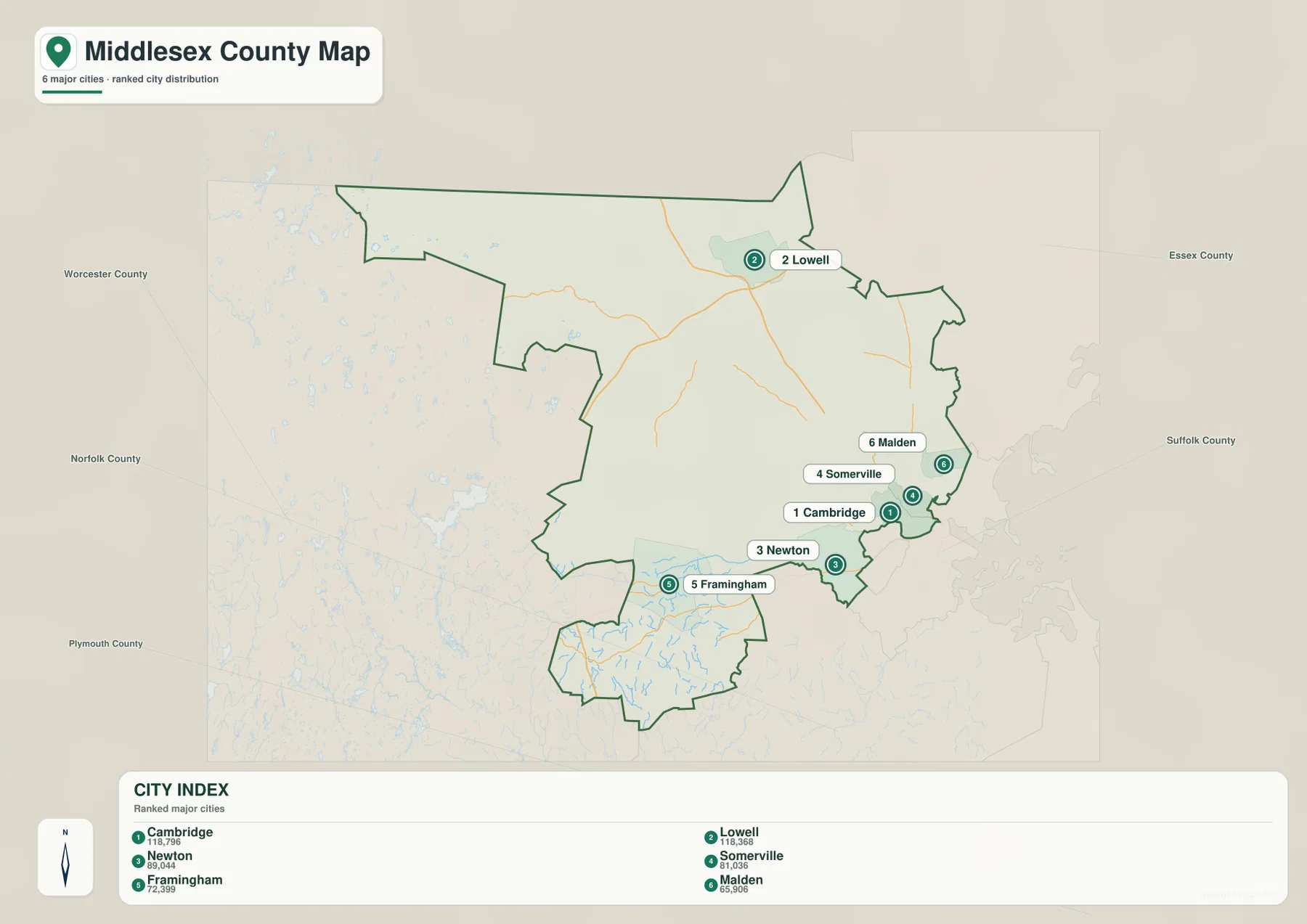
The CITY INDEX prints values of 118,796 for Cambridge, 118,368 for Lowell, 89,044 for Newton, 81,036 for Somerville, 72,399 for Framingham, and 65,906 for Malden. Those numbers should be understood as values from the dataset used to create this specific map, not as a promise that they are the latest official population estimates. Population figures change over time. When an exact current total matters, the U.S. Census Bureau’s current county and place data are the appropriate source to check.
Cambridge and Somerville are shown almost side by side, and Malden lies only a short distance to the northeast on the map. Newton is southwest of Cambridge but remains within the same broad southeastern concentration. The general county map adds the road context around this cluster, including I-90 and I-93. The city map itself does not show a travel route, travel time, or direct connector line, so it should be treated as a distribution graphic rather than a transportation diagram.
Lowell tells a different story. Its marker is far from the four southeastern ranked cities and near the northern edge of the county. On the general map, Route 3 helps place Lowell within the road network. On the terrain-and-water map, the Merrimack River becomes the strongest natural reference in the same area. Looking across all three maps therefore gives Lowell a distinct northern context rather than treating it as merely another point in the Boston suburban cluster.
Framingham is equally useful as a southwestern reference. It sits far from both Lowell and the Cambridge-Somerville group, and the general map shows I-90 crossing the area on its way toward Newton and the Boston side. Marlborough appears farther west on the general map even though it is not one of the six ranked cities. That comparison is a reminder that a ranked city graphic is selective by design. It emphasizes a few locations and should not be mistaken for a complete list of important communities in Middlesex County.
Other general-map cities such as Waltham, Woburn, Medford, Everett, and Marlborough are absent from the ranking panel. This is useful when preparing a presentation because the six-city version removes visual clutter, but it also limits what can be concluded from the page. Use it to compare the selected city positions and their printed values. Use the general map when a broader set of communities, county boundaries, and road references needs to be visible at the same time.
Merrimack, Assabet, Sudbury, Mystic, and Charles rivers divide the county into distinct water settings
The terrain-and-water map changes the emphasis from highways and city labels to rivers, ponds, tributaries, and relief. The Merrimack River is the strongest feature in the north. The Assabet River crosses the west-central part of the county, the Sudbury River appears farther south, and the Mystic and Charles rivers occupy different parts of the southeast. The Shawsheen River is also labeled toward the northeastern and central-eastern side. These waterways do not form one simple countywide chain, so it is more useful to read the map by region.
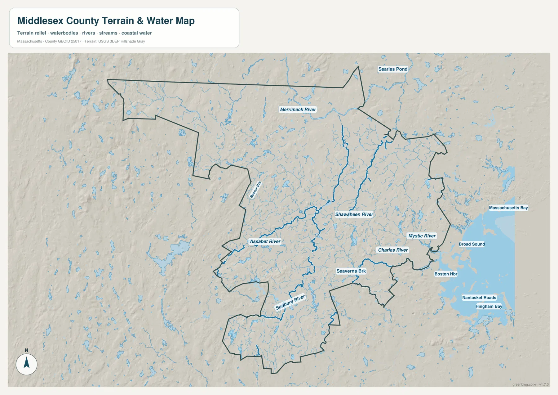
In the north, the Merrimack River passes through the Lowell area and provides a natural reference that is easy to match with the general and city maps. Smaller tributaries and ponds are spread around the northern boundary, and Searles Pond is labeled just beyond the county outline. The map therefore gives a little regional context outside Middlesex County as well as the rivers within it. When the Lowell marker on the city map is compared with this river layer, the northern city’s separation from Cambridge and Newton becomes even more obvious.
The Assabet and Sudbury rivers organize much of the western and southwestern interior. The Assabet River runs through the west-central area, while the Sudbury River is shown farther south near the broad Framingham side of the county. Numerous smaller lakes, ponds, and streams appear between and around them. On the general map, this part of Middlesex County can look comparatively open because fewer major city labels are printed there. The water map fills in that space and shows that the interior contains a dense network of smaller drainage features.
The southeastern waterways belong to a very different setting. The Mystic River is close to the Medford-Malden-Everett side, while the Charles River provides a strong reference near Waltham, Newton, Cambridge, and the Boston boundary. Massachusetts Bay, Broad Sound, Boston Harbor, Nantasket Roads, and Hingham Bay appear farther east as surrounding geographic context. Those coastal labels should not be interpreted as if all of the open water lies inside Middlesex County; the county outline shows that much of that marine area is outside its boundary.
Shaded relief also changes from one side of the county to the other. The western and northwestern interior appears more rolling and broken, with many ponds and stream valleys. Toward the southeast, the surface looks lower and the city pattern becomes much denser. This is a useful regional comparison, but the shading is not a contour survey and does not provide an exact elevation for a house, road, trail, or construction site. A dedicated elevation dataset is required whenever precise height or slope matters.
The blue river symbols also need to be read as map symbols rather than measurements. Line width does not equal the actual width or flow of a river, and the map does not show flood zones, water quality, channel depth, legal shoreline limits, or navigation restrictions. That distinction is especially important around the Charles and Mystic rivers, where a regional water reference and a flood or navigation product would answer very different questions. The map is intended to show where named waterways sit in relation to the county.
A simple regional method makes the water map easier to use: start with the Merrimack in the north, move to the Assabet and Sudbury rivers through the inland west and southwest, then finish with the Mystic and Charles in the southeast. The Shawsheen River adds another reference on the eastern side. Matching those waterways with Lowell, Framingham, Waltham, Cambridge, Medford, and Malden helps explain why the county’s urban geography and water geography do not follow one single pattern.
Choosing the right map for a road overview, city comparison, or river reference
For a first overview of Middlesex County, the general map is the strongest starting point. It keeps the county outline, major roads, selected communities, and surrounding Boston context in one frame. Finding Cambridge, then Waltham and Framingham, and finally Lowell is a practical way to understand the county’s scale. I-495 helps define the outer western side, I-93 helps with the eastern urban area, I-90 is useful in the south, and Routes 2 and 3 provide additional central and north-south references.
The six-city map is better when a presentation needs less visual detail. It makes the Cambridge-Newton-Somerville-Malden concentration obvious and separates Lowell in the north from Framingham in the southwest. Because it omits many other cities and most road labels, it should not be used as a complete settlement map. The terrain-and-water map answers a different question by showing where the Merrimack, Assabet, Sudbury, Mystic, Charles, and Shawsheen rivers sit among the county’s inland and urban areas.
For printing, the original high-resolution JPG files in the downloadable ZIP will generally be sharper than the web-sized versions embedded in the article. Each file emphasizes a different question, so the most effective choice depends on whether roads, selected cities, or waterways matter most. Current construction, traffic closures, legal boundaries, flood hazards, water conditions, and precise elevation should always be checked through the current authoritative source for that subject rather than inferred from these regional reference maps.
Frequently Asked Questions
Are Cambridge and Lowell part of one compact urban cluster on these maps?
No. Both are in Middlesex County, but Cambridge is on the southeastern Boston side while Lowell is far to the north near the Merrimack River. The general map shows a broad middle section between them, and Route 3 provides one useful north-south reference. The city map makes the separation especially easy to see because Lowell stands apart from the Cambridge-centered southeastern group.
Are the printed Cambridge 118,796 and Lowell 118,368 values current population estimates?
They should not be treated as guaranteed current estimates. They are values printed on the supplied city map from the dataset used to create that graphic. Population estimates change with the reference year and update cycle. Use the values for the map’s ranking context, and check the current U.S. Census Bureau data when an up-to-date population figure is required.
Can the Merrimack River and Charles River be compared on one Middlesex County map?
Yes. The terrain-and-water reference shows the Merrimack River in the northern Lowell area and the Charles River in the southeast near Waltham, Newton, Cambridge, and the Boston side. It also labels the Assabet, Sudbury, Mystic, and Shawsheen rivers, which makes it useful for comparing the county’s different water settings in one view.
Map File Information
The ZIP contains the original high-resolution JPG versions of the general Middlesex County map, the ranked city-distribution map, and the terrain-and-water reference described on this page.
- Included Files: general county map, ranked city-distribution map, terrain-and-water reference map
- File Type: JPG
Related Maps
Sources and References
The following official resources are useful for checking current Middlesex County statistics, administrative boundaries, hydrography, and local public-land information.
- U.S. Census Bureau – Middlesex County QuickFacts
- Mass.gov – Middlesex Fells Reservation
- U.S. Census Bureau TIGER/Line Shapefiles
- USGS National Hydrography
Green Map creates custom-edited map images using open geographic data sources such as geoBoundaries, Natural Earth, OpenStreetMap, and government open data. These maps are edited visual materials, not raw data files, and are provided for education, documents, presentations, and graphic reference.