Franklin County occupies a mountainous part of northwestern Massachusetts where broad river valleys cut through uplands and connect a series of small town centers. Greenfield is the easiest place to orient the county because the Connecticut River corridor, the Deerfield River, Interstate 91, and Route 2 all come together within a relatively compact area. To the east, the Millers River leads toward Orange and Millers Falls. To the west, the landscape becomes more rugged and roads follow narrower valleys through the hills. Looking at roads, water, and relief together gives a much clearer picture of the county than any single place name can provide.
This page includes a general county map, a major-city index map, and a terrain-and-water reference map, with high-resolution JPG versions available for download. The general map labels Greenfield, Turners Falls, Millers Falls, Orange, Northfield, Deerfield, and South Deerfield along with I-91, Route 2, Routes 5 and 10, and several connecting state routes. The city map strips away most of that detail to emphasize Greenfield. The terrain-and-water map brings the Connecticut, Deerfield, Green, and Millers rivers forward and adds reservoirs, lakes, tributaries, and shaded relief.
Table of Contents
Using Greenfield as the orientation point for roads and nearby communities
Greenfield sits close to the geographic center of the most heavily connected part of Franklin County. Turners Falls lies just to the east, Millers Falls farther southeast, and Deerfield and South Deerfield to the south. Orange is farther east along the Route 2 corridor, while Northfield provides a useful reference near the northern edge of the county. These places form a practical framework for reading the map because they connect the county’s major north-south and east-west routes with its principal river valleys.
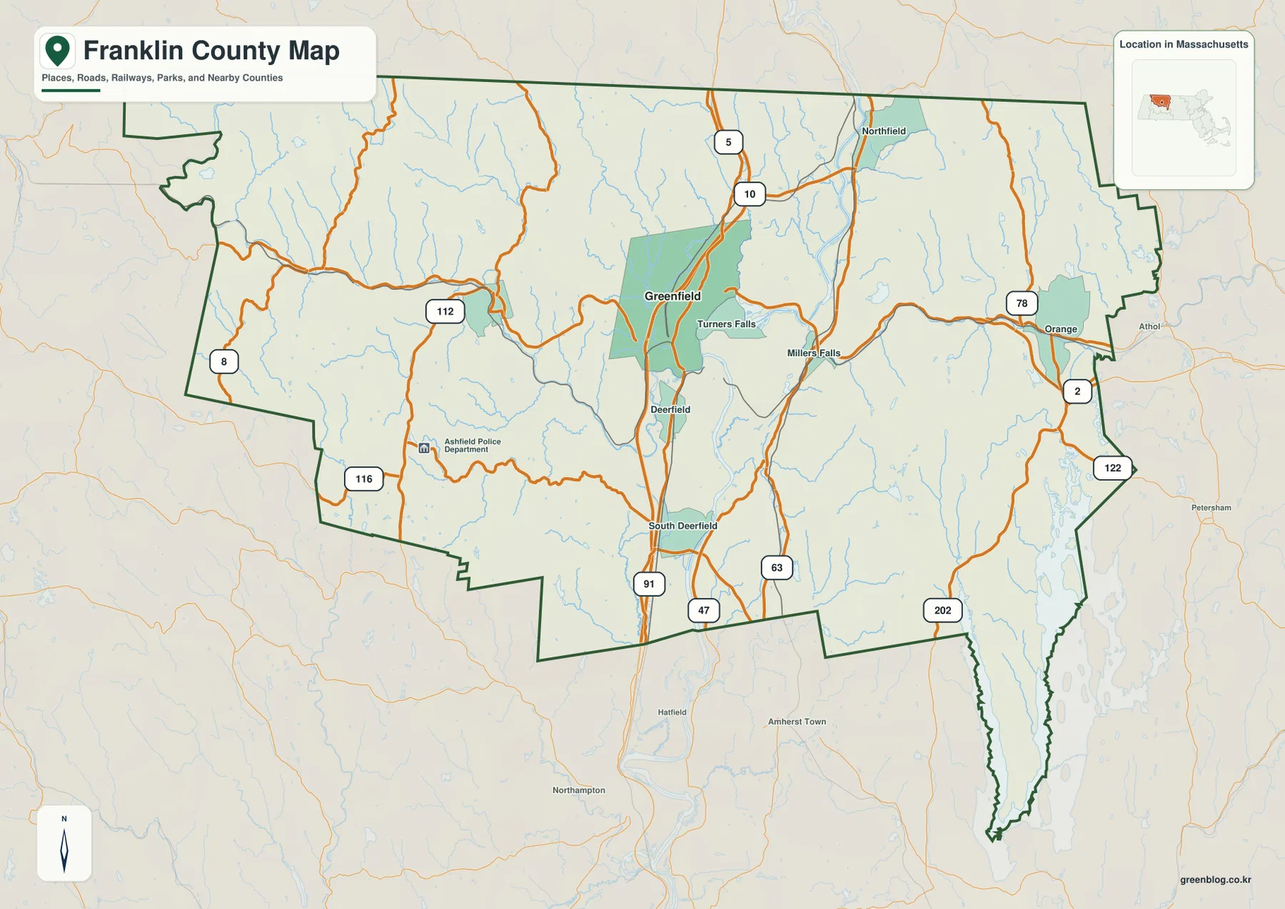
Interstate 91 is the strongest north-south reference on the map. It passes South Deerfield and Greenfield before continuing toward the northern part of the county. Route 2 provides the clearest east-west reference, crossing the hill country in the west, reaching Greenfield, and then continuing toward Orange. Routes 5 and 10 run near the Connecticut River corridor, while Route 63 gives another north-south line on the east side of the river. Because several important roads converge near Greenfield, the city works well as the point from which to compare the rest of the county.
The eastern side has a different road pattern. Around Orange, Route 2 meets or approaches Routes 78, 122, and 202, and Athol appears just beyond the county boundary as an outside reference. Millers Falls is positioned closer to the Connecticut River system, where Route 63 and local roads help connect the eastern uplands with the central valley. Turners Falls is even closer to Greenfield, but the nearby river bends make the geography more complex than the short map distance might suggest.
Western Franklin County is visibly less grid-like. Route 112 runs through the western interior, Route 116 crosses the southwest, and Route 8 appears near the far southwestern edge. Smaller streams are dense in this part of the map, and the roads curve through the same hill-and-valley landscape. Instead of thinking of the west simply as the area farthest from Greenfield, it is more useful to see it as a network of narrow corridors separated by higher ground. That relationship becomes even clearer on the terrain map.
Why the city index highlights only Greenfield while the county map shows many centers
The major-city index is intentionally much simpler than the general map. Its CITY INDEX lists Greenfield as the single ranked city and shows a value of 17,664 beneath the name. That number should be treated as the value used to build this particular map layer rather than as a claim about the current official population. The map is not a complete municipal or settlement map; its purpose is to make the selected major city easy to locate without the distraction of many roads and smaller labels.
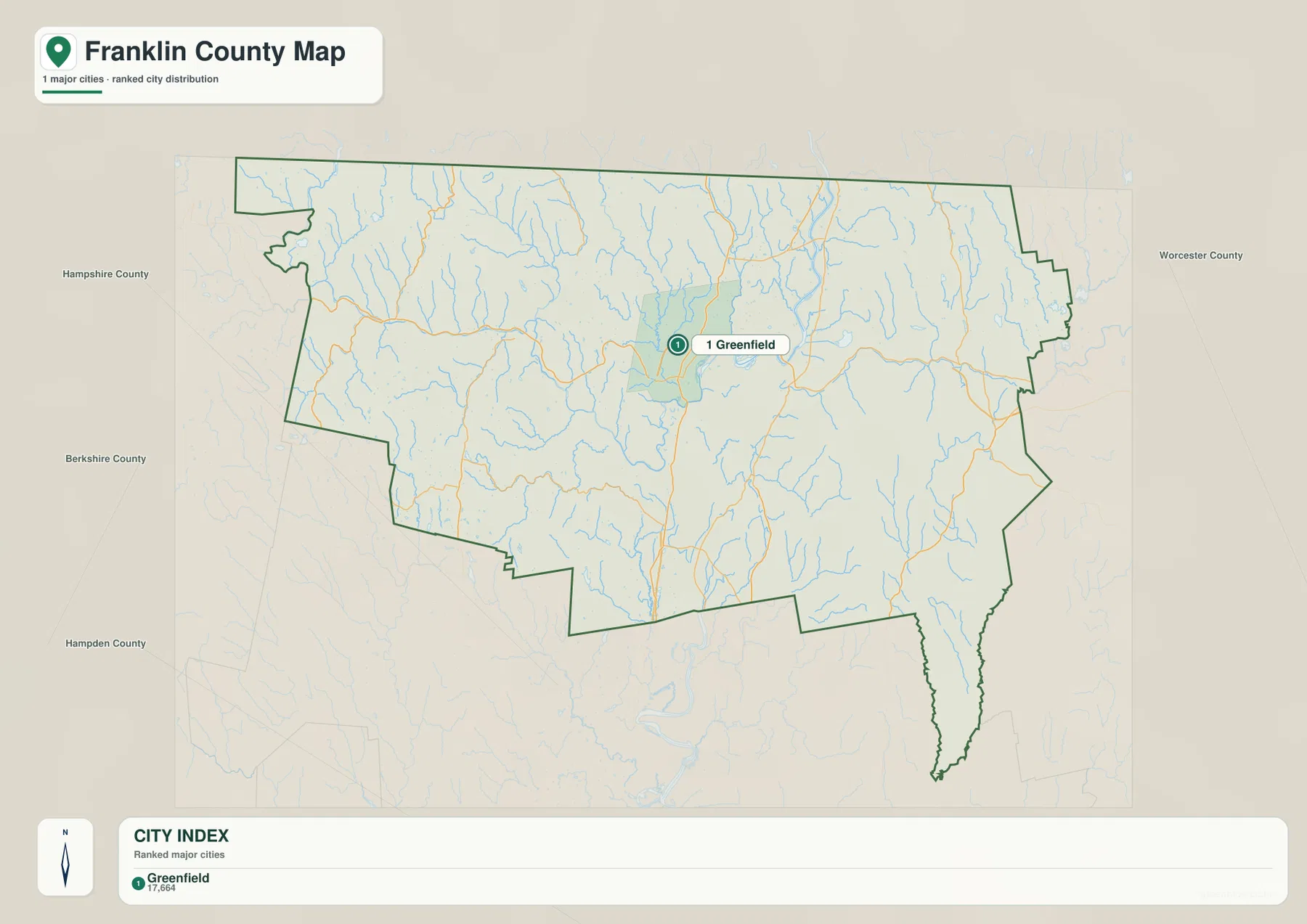
With most labels removed, Greenfield’s position becomes easy to understand. It lies near the central part of the county rather than at an outer edge. The basemap also displays the names Berkshire, Hampshire, Hampden, and Worcester County around the broader area. Those labels can provide regional context before a reader moves to the more detailed general map, but the city layer itself is not intended to define county adjacency.
The single marker does not mean Franklin County lacks other important towns and village centers. Turners Falls, Millers Falls, Orange, Northfield, Deerfield, and South Deerfield are all visible on the general map and serve as useful local references. The Franklin Regional Council of Governments describes itself as a regional service organization for the county’s 26 municipalities, which helps explain why one ranked city cannot represent the full local settlement pattern. The city map is best used as a locator, while the general map provides the fuller geographic context.
The contrast is especially useful around Greenfield, Turners Falls, and Millers Falls. These communities are close together on the county map, but they relate to different roads and waterways. Greenfield is associated most clearly with I-91 and Route 2. Turners Falls sits near a prominent bend and crossing area of the Connecticut River, while Millers Falls is positioned near the Millers River as it approaches the Connecticut system. Orange is farther east along Route 2. Seeing those differences prevents the city index from being mistaken for a complete picture of local geography.
The Connecticut River system with the Deerfield, Green, and Millers rivers
The Connecticut River is the dominant water feature on the terrain-and-water map. It runs north to south through the central-eastern part of Franklin County and creates a broad corridor around Greenfield, Turners Falls, and Deerfield. From the west, the Deerfield River crosses the hill country and reaches the Connecticut near the Greenfield-Deerfield area. Massachusetts water-quality documentation describes the lower Deerfield River segment from its confluence with the Green River in Greenfield to its confluence with the Connecticut River at Greenfield and Deerfield, matching the relationship visible on the map.
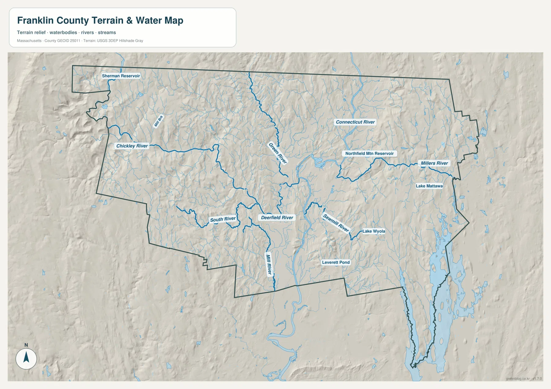
The Green River descends from the northwestern side of the central valley toward Greenfield, where it joins the lower Deerfield system. West of Greenfield, the Deerfield River is joined by numerous smaller streams. The Chickley River is labeled in the western hills, while the South River and Mill River appear farther south. The shaded relief makes it clear that these tributaries are not crossing a flat plain. They occupy valleys between ridges, which is why both streams and roads bend repeatedly as they move through western Franklin County.
The eastern side belongs to another set of water features. The Millers River extends across the Orange area toward Millers Falls, and Lake Mattawa is marked close to Orange. Northfield Mountain Reservoir lies east of the Connecticut River in the north-central portion of the map. Farther south and east, the Sawmill River, Lake Wyola, and Leverett Pond appear among smaller tributaries. These features show that eastern Franklin County is not simply a continuation of the broad Connecticut valley; hills and smaller basins divide the drainage there.
Sherman Reservoir near the northwestern edge and the Chickley River provide useful reference points for the more rugged west. The hillshade is much stronger there than along the central river corridor, and narrow valleys are closely spaced. This helps explain why roads such as Routes 112 and 116 follow winding paths rather than straight lines. By comparing the general map with the terrain map, a reader can see how transportation routes often use the same low corridors created by streams and rivers.
This water map is a regional reference, not a flood, navigation, wetland-regulation, dam-safety, or engineering product. Line thickness does not represent the exact width or depth of a river, and the shaded relief is not survey-grade elevation data. For flood hazards, water quality, current reservoir operations, or legal water boundaries, the appropriate state or federal datasets should be consulted directly. Here, the map is most useful for understanding how the county’s major waterways fit among its hills and communities.
The broad Connecticut River valley versus the hillier western and northern areas
Relief is easiest to understand by separating the central valley from the surrounding uplands. Along the Connecticut River, the terrain appears broader and smoother, and several labeled communities cluster in or near that corridor. Greenfield, Turners Falls, Deerfield, and South Deerfield all sit close enough to the river system that the valley becomes a natural organizing feature. I-91 and Routes 5 and 10 also follow this lower, more open north-south corridor, reinforcing the relationship between topography and transportation.
Western Franklin County shows much stronger relief. The Deerfield and Chickley rivers occupy narrow valleys, smaller tributaries branch into the hills, and few roads form long straight lines. On the general map, the area can look comparatively empty because there are fewer large place labels. The terrain map reveals the opposite kind of complexity: many ridges, valleys, and streams are packed into that space. For regional study, this is an important reminder that a low density of labels does not mean a simple landscape.
Northfield provides another useful comparison. The Connecticut River continues northward, but the hills press closer to the river than they do around the broader Greenfield-Deerfield area. Routes 5 and 10 continue through the northern corridor, while Northfield Mountain Reservoir sits in the uplands east of the river. Tributaries descend from both sides. The result is a narrower and more enclosed river setting than the central valley, even though the same major river remains the primary geographic reference.
The southeastern projection of the county has its own pattern. Route 202 passes through that side, while Lake Wyola, Leverett Pond, the Sawmill River, and many small streams appear on the terrain map. The county boundary also extends southward in an irregular shape rather than following a simple rectangle. Comparing the boundary and water layers helps make sense of this extension and shows why the southeastern part feels separate from the Greenfield-centered road network.
Choosing the right Franklin County map for roads, city orientation, and water
For the most complete orientation, start with the general county map. Locate Greenfield, then use I-91 as a north-south guide and Route 2 as an east-west guide. Add Turners Falls, Millers Falls, Orange, Northfield, Deerfield, and South Deerfield to build the local settlement pattern. Routes 112, 116, 63, 78, 122, and 202 can then be used for more detailed connections to the western, northern, and eastern parts of the county.
The city map is better when a clean graphic is needed. Because it emphasizes only Greenfield, it works well on a slide or small screen where too many road labels would be distracting. It also gives quick regional context through the neighboring county names. It should not be used as a municipal-boundary map or as evidence that other towns and village centers are absent. Pairing it with the general map keeps the simplification clear.
The terrain-and-water map is the best choice when rivers, reservoirs, lakes, and relief are central to the explanation. It makes the meeting of the Connecticut and Deerfield river systems easy to see, places the Green and Millers rivers in context, and shows how features such as Sherman Reservoir, Northfield Mountain Reservoir, Lake Mattawa, Lake Wyola, and Leverett Pond sit within the hills. It is also the most useful map for explaining why road corridors bend and narrow in the western and northern parts of the county.
The downloadable JPG files are suitable for screen reference, printing, classroom material, presentations, and regional comparison. They are not substitutes for legal boundary surveys, property records, engineering plans, flood maps, or current traffic information. When a task requires authoritative boundaries or hydrography, current U.S. Census Bureau, USGS, Massachusetts, or local agency data should be checked alongside these reference maps.
Frequently Asked Questions
Why does the city map show only Greenfield?
The supplied city map is a simplified ranked-city layer rather than a complete map of every municipality or settlement. It highlights Greenfield so its location is easy to see. The general county map adds Turners Falls, Millers Falls, Orange, Northfield, Deerfield, South Deerfield, and more road detail, so the two maps are intended to be used together.
Which map is best for seeing where the Connecticut and Deerfield rivers meet?
The terrain-and-water reference map is the clearest choice. It shows the Connecticut River running north-south and the Deerfield River arriving from the west near Greenfield and Deerfield, with the Green River joining the lower Deerfield system nearby. For flood zones, water depth, water quality, or regulatory questions, use the specialized official map for that purpose instead.
Which roads are easiest to use for basic Franklin County orientation?
I-91 is the simplest north-south reference through the central valley, while Route 2 is the clearest east-west reference across the county. Starting at Greenfield and following those two routes makes it easier to place South Deerfield, Northfield, Orange, and the western hill country. Current road closures and driving conditions should always be checked separately.
Map File Information
Map file details
- Included Files: general county map, major-city index map, terrain-and-water reference map
- File Type: JPG
Related Maps
Sources and References
These public and official resources are useful for checking Franklin County regional context, river information, boundaries, and hydrography.
- Franklin Regional Council of Governments
- Mass.gov – Integrated Lists of Waters and Related Reports
- U.S. Census Bureau TIGER/Line Shapefiles
- USGS National Hydrography
Green Map creates custom-edited map images using open geographic data sources such as geoBoundaries, Natural Earth, OpenStreetMap, and government open data. These maps are edited visual materials, not raw data files, and are provided for education, documents, presentations, and graphic reference.