Caroline County sits on Maryland’s Eastern Shore as a long inland county between the Choptank River drainage and the Delaware state line. Denton is near the middle-south of the county, Greensboro, Ridgely, and Goldsboro extend northward, and Preston and Federalsburg anchor the southern end. The maps on this page show the county boundary, major roads, ranked settlements, rivers and creeks, and the county’s low-relief elevation pattern. Matching high-resolution JPG files are available together in a downloadable ZIP archive.
Caroline County’s official resources list ten incorporated municipalities: Denton, Federalsburg, Goldsboro, Greensboro, Henderson, Hillsboro, Marydel, Preston, Ridgely, and Templeville. Denton is the county seat. The county is bordered by Queen Anne’s, Talbot, and Dorchester counties in Maryland and by Kent and Sussex counties in Delaware, which explains the long, almost straight eastern edge and the more irregular western side shaped in part by waterways.
Table of Contents
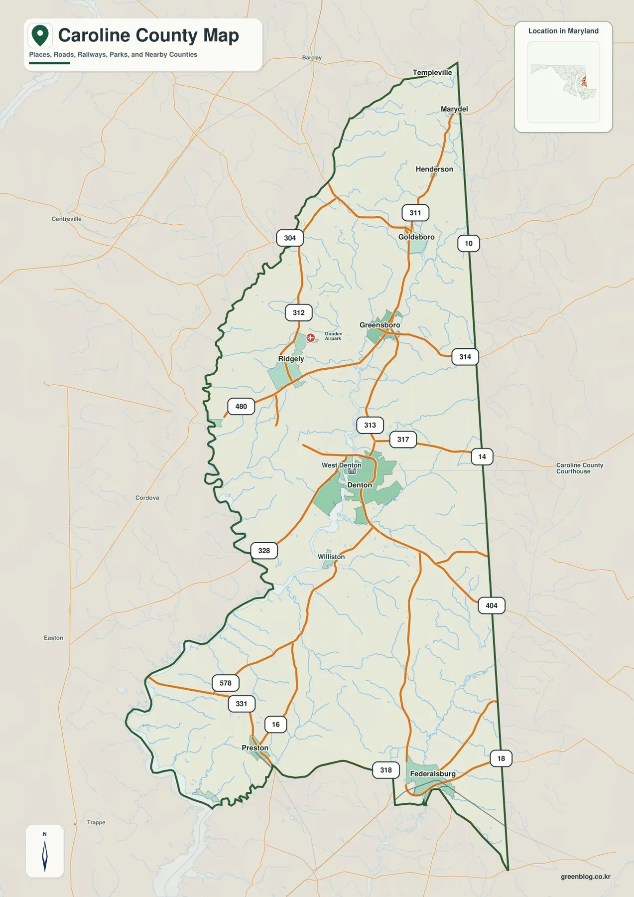
Denton sits between a northern chain of towns and the Federalsburg-Preston south
Denton is the easiest place to begin on the general county map. It lies in the south-central part of Caroline County, with West Denton immediately beside it. Moving north brings Greensboro and Ridgely into view, followed by Goldsboro, Henderson, Marydel, and Templeville toward the upper end of the county. Because Caroline County is much longer north to south than east to west, following the settlement names vertically provides a simple way to understand the whole map.
The southern half has a different arrangement. Preston is on the southwestern side, while Federalsburg lies farther southeast close to the Delaware-facing boundary. Williston appears between Denton and the southern communities. This layout shows that the county is not centered around one large urban cluster; its incorporated places are distributed through a long rural landscape instead.
Ridgely and Greensboro form a useful middle-northern pair, with Gooden Airport labeled nearby. North of them, Goldsboro provides another strong landmark before the map reaches Henderson, Marydel, and Templeville. Streams occupy many of the spaces between towns, so local roads often curve around low ground rather than following a perfectly regular grid.
The boundary itself changes character from side to side. The eastern edge along Delaware is comparatively straight, while the western side bends repeatedly, especially south of Denton. That irregular western outline becomes much easier to understand on the water map, where the Choptank River and connected creeks are shown in greater detail.
MD 404 and MD 313 provide the clearest road references through the middle of the county
MD 404 is one of the strongest road labels on the map. It crosses the county around the Ridgely-Greensboro area and provides an east-west reference between Maryland’s interior and the Delaware side. Near the center, the highway network connects naturally with roads leading toward Denton, making the middle of the county easier to read than the many smaller local roads would suggest.
MD 313 runs through the Greensboro-Denton corridor and continues southward, giving the county a useful north-south spine. MD 314 heads east from the Greensboro area, while MD 311 and MD 10 appear in the northern part near Goldsboro, Henderson, and Marydel. These routes divide the upper county into understandable sections without requiring the reader to memorize every minor road.
South of Denton, MD 328 reaches toward the western boundary, and MD 331, MD 16, MD 578, and MD 318 help organize the Preston-Federalsburg area. MD 18 is labeled near the southeastern edge. For a quick orientation, start with MD 404 and 313, then add the road closest to the town or part of the county you need.
This is not a live navigation map. Road work, closures, traffic, and travel time can change, so actual driving should be checked with current Maryland transportation information and a navigation service. The road layer here is best for understanding where communities sit relative to the major state routes.
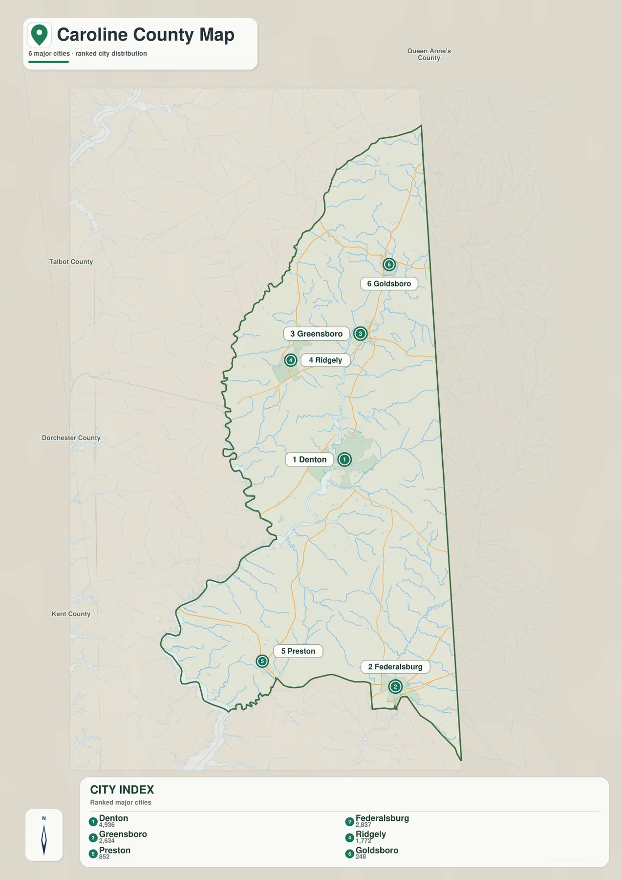
The City Index shows six ranked settlements spread along the county’s length
The City Index ranks Denton, Federalsburg, Greensboro, Ridgely, Preston, and Goldsboro. The printed figures are 4,936 for Denton, 2,837 for Federalsburg, 2,634 for Greensboro, 1,772 for Ridgely, 852 for Preston, and 248 for Goldsboro. The graphic does not state a reference year or statistical definition, so these values should not be presented as current population counts. Current figures should come from the latest U.S. Census Bureau data.
The geographic arrangement is more useful than the ranking itself. Denton is near the middle-south, Federalsburg is far to the southeast, and Preston lies to the southwest. Greensboro and Ridgely sit closer together north of Denton, while Goldsboro is farther north. The pattern reinforces the county’s long shape and the relatively even spread of small communities rather than one dominant urban center.
The index does not include every incorporated municipality. Caroline County’s official list also includes Henderson, Hillsboro, Marydel, and Templeville. The City Index is therefore a simplified selection of ranked places, not a complete administrative list. Readers looking for all municipal locations should use the general county map together with official county information.
No straight-line distance labels or connector lines appear on this graphic. It should not be used to estimate road mileage between Denton and Federalsburg, Greensboro, or any other place. For travel, return to the road map and use current routing information.
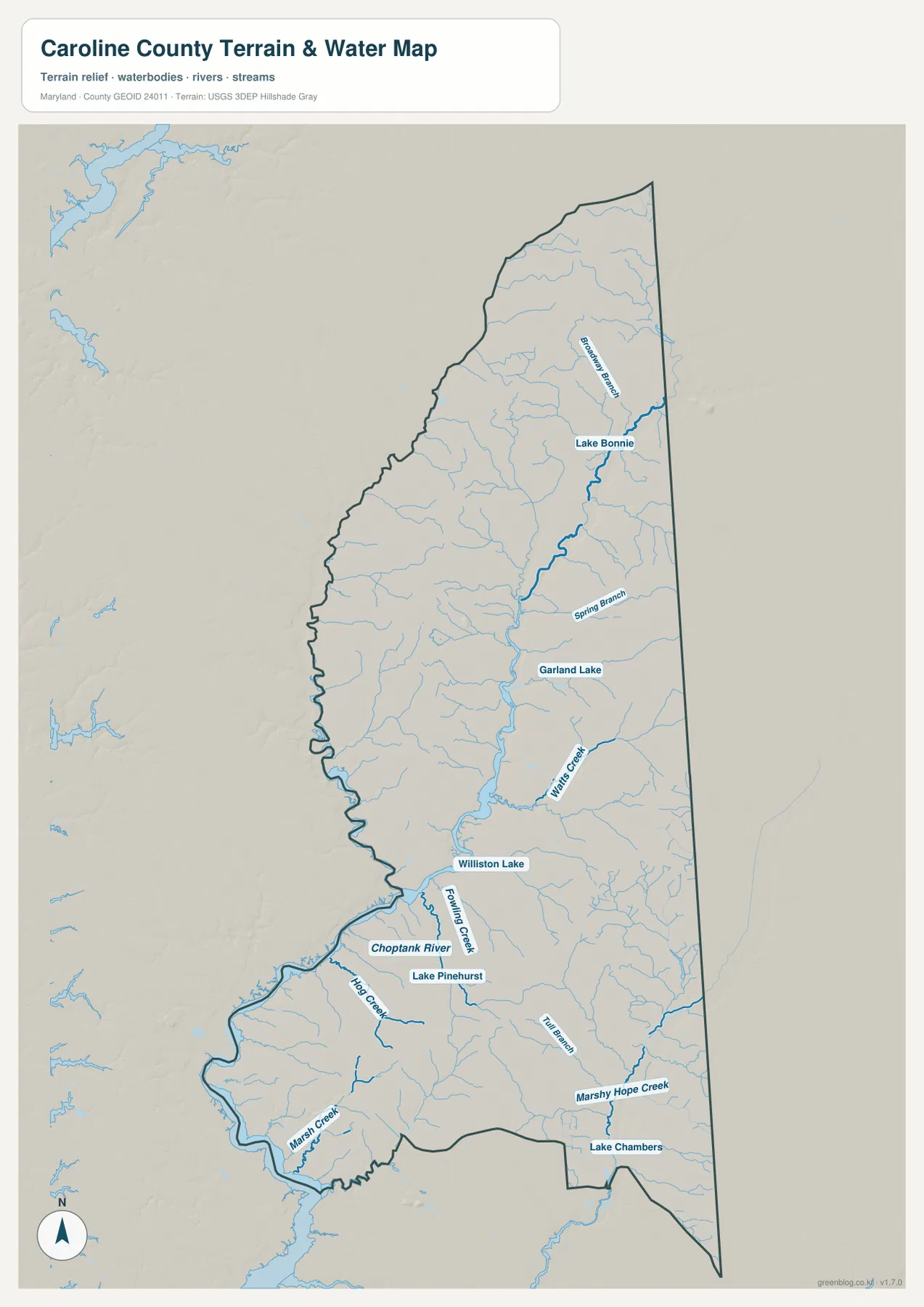
The Choptank River and a dense network of creeks shape the western and southern lowlands
The Choptank River is the largest named water feature on the map and follows the southwestern side of Caroline County. Fowling Creek, Hog Creek, and Marsh Creek are labeled nearby, and their low corridors help explain the irregular western boundary. These streams contrast with the straight Delaware-facing edge on the opposite side of the county.
Farther north and through the center, Watts Creek, Spring Branch, and Beaver Branch are useful landmarks. Lake Bonnie and Garland Lake appear in the upper half, while Williston Lake and Lake Pinehurst sit closer to the Denton-Choptank area. The map shows a county crossed by many small waterways even though it does not have a Chesapeake Bay shoreline.
The southeastern side contains Marshy Hope Creek and Tull Branch near the Federalsburg area. Here, small waterways converge through low terrain before leaving the county. Their arrangement helps explain why the southern map feels more dissected by streams than the simple road layer first suggests.
Caroline County’s own material describes it as the only landlocked county on Maryland’s Eastern Shore. That does not make water unimportant. Instead of a major bay shoreline, the county is characterized by rivers, creeks, ponds, and drainage corridors that reach through most parts of the landscape.
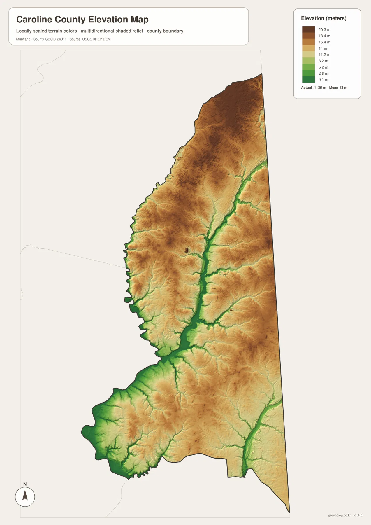
Elevation stays low across the county, with stream valleys forming the lowest corridors
The elevation map reports an actual range from -1 to 35 meters and a mean elevation of 13 meters. Those values reflect Caroline County’s low Eastern Shore setting. The map is not completely uniform, however: slightly higher tan and brown areas are separated by green low corridors that closely follow the stream network.
The northern and northeastern parts include some of the relatively higher land, while the central and southern creek valleys stand out in green. Low terrain is especially visible along the Choptank River side and around the branching waterways south of Denton. Comparing the elevation and water maps makes the connection between streams and lower ground easy to see.
Denton sits in a landscape of small elevation differences rather than steep hills. Narrow drainage corridors are lower than the surrounding fields and settlement areas, and similar patterns continue toward Federalsburg, where Marshy Hope Creek and its branches occupy low ground. Preston and the southwestern corner also grade toward the Choptank River system.
This elevation layer is a countywide reference, not a survey. The -1 to 35 meter range should not be applied to a specific building or parcel without checking authoritative data. Engineering, drainage design, property surveying, and flood-risk work require detailed USGS elevation information, professional survey data, and dedicated FEMA or local flood products.
Use the road map for towns and routes, then switch layers for water and relief
The general county map is the best starting point for Denton, Greensboro, Federalsburg, MD 404, MD 313, and the Delaware boundary. The City Index provides a cleaner look at six ranked settlements, while the water map is better for the Choptank River and the many creeks that influence the western and southern county. The elevation view adds a final layer by showing how little overall relief the county has and where the stream valleys sit lower than the surrounding land.
The downloadable originals are JPG files measuring 2572 × 3638 pixels each. They can be used in full-page documents, classroom material, presentations, or personal reference, and individual areas can be enlarged when small labels need closer inspection. Enlargement does not add live road conditions, parcel boundaries, flood zones, or survey-grade elevation, so specialized decisions should always use current official data.
Caroline County is easiest to understand as a long Eastern Shore county organized by small towns, state roads, and numerous creek valleys rather than by a major city or coastline. Following the map from Goldsboro and Greensboro through Denton to Preston and Federalsburg provides a simple geographic sequence, while the Choptank River system explains much of the western and southern landscape.
Frequently Asked Questions
What is the county seat of Caroline County, Maryland?
Denton is the county seat. It sits in the south-central part of the county and provides a useful reference between Greensboro and Ridgely to the north and Preston and Federalsburg to the south.
Does the City Index show every incorporated municipality in Caroline County?
No. The City Index ranks six places, but official Caroline County resources list ten incorporated municipalities, including Henderson, Hillsboro, Marydel, and Templeville in addition to the six ranked locations. The index should therefore be treated as a simplified settlement view rather than a complete municipal list.
Can the -1 to 35 meter elevation range be used for surveying or flood decisions?
No. It is useful for understanding broad countywide relief only. Precise property elevation should come from authoritative USGS or professional survey data, and flood decisions should rely on current FEMA and local flood information.
Map File Information
The ZIP archive contains high-resolution JPG maps of Caroline County matching the map themes described on this page.
- Included Files: county and major roads map, City Index map, terrain and water map, elevation map
- Printable Size: 2572 × 3638 pixels each
- File Type: JPG
Related Maps
Sources and References
- Caroline County, Maryland – Official Website
- Caroline County – Local Resources and Municipalities
- U.S. Census Bureau – TIGER/Line Shapefiles
- USGS – National Hydrography
- USGS – 3D Elevation Program
Green Map creates custom-edited map images using open geographic data sources such as geoBoundaries, Natural Earth, OpenStreetMap, and government open data. These maps are edited visual materials, not raw data files, and are provided for education, documents, presentations, and graphic reference.