Iberville Parish is one of those Louisiana parishes whose shape makes much more sense once the rivers and bayous are visible. The Mississippi River curves through the eastern side, placing Plaquemine and St. Gabriel on opposite banks, while a broad western section stretches toward the Grand River system and the waterways associated with the Atchafalaya Basin. This page uses the supplied maps to explain the parish through its communities, roads, boundary, and water network. The matching high-resolution JPG map files can also be downloaded together as a ZIP.
Plaquemine is the most useful starting point for orientation because it is the parish seat and sits near the Mississippi River in the central-eastern part of the parish. St. Gabriel lies across the river to the east, while White Castle is farther south. A separate group of communities—Maringouin, Rosedale, and Grosse Tete—occupies the northern part of Iberville Parish near Interstate 10 and the Bayou Grosse Tete corridor. Official Iberville tourism material likewise describes a parish divided by the Mississippi River and connected on the west to the Atchafalaya Basin landscape.
Table of Contents
A parish organized around both banks of the Mississippi River
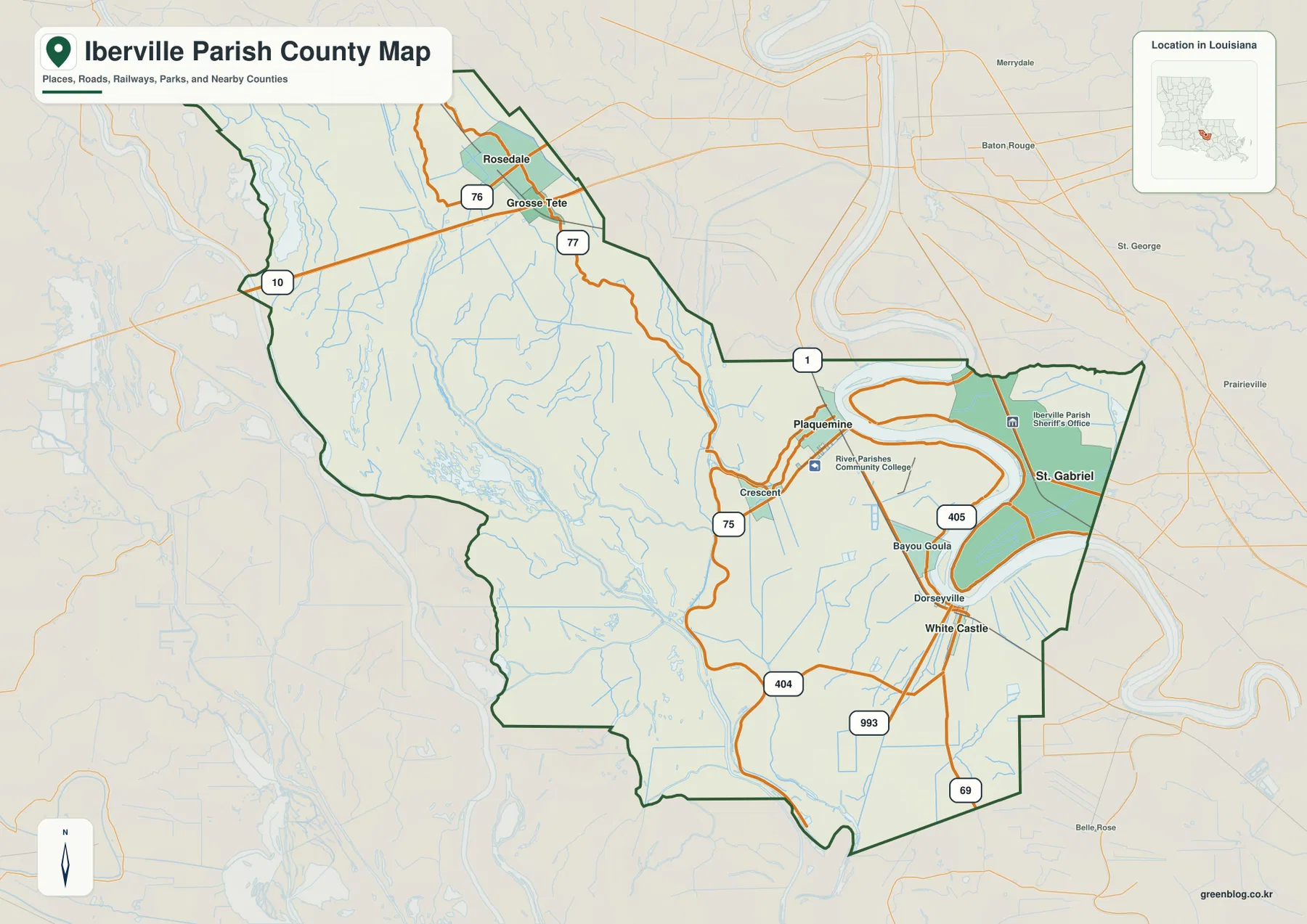
The general parish map makes the Mississippi River the dominant landmark on the eastern side. Its broad bends cut between Plaquemine on the west bank and St. Gabriel on the east side, creating a parish layout that cannot be understood as a single compact block of land. Louisiana Highway 1 crosses the river north of Plaquemine and provides a clear visual reference for how the two sides relate to one another. Farther south, the map labels Bayou Goula and White Castle, with LA 75, LA 405, LA 993, and LA 69 helping define the road network through the lower part of the parish.
The parish boundary follows this river-oriented geography rather than forming a simple rectangle. The eastern section extends around St. Gabriel, while the much larger western side reaches into a landscape filled with smaller waterways. That arrangement matters when reading the map: two places can appear close together in straight visual distance yet still be separated by the Mississippi River. For a broad overview, the general map is the strongest of the three because it keeps the boundary, communities, major highways, and river in one view.
Northern Iberville follows I-10 and the Bayou Grosse Tete corridor
The northern part of the parish has a noticeably different settlement pattern from the Plaquemine–St. Gabriel area. Maringouin sits near the northern tip, with Rosedale and Grosse Tete farther south. Interstate 10 passes by Grosse Tete and provides the largest east-west transportation line shown in this section of the map. LA 76 is a useful reference around Rosedale, while LA 77 runs near Grosse Tete before continuing toward the central part of the parish.
These communities are also tied to a dense water network. Bayou Grosse Tete and Bayou Maringouin run through the same general northern landscape, and many smaller channels spread across the low-lying western side. As a result, northern Iberville is easier to understand when roads and waterways are considered together. The communities are relatively close to one another, but they are separated from Plaquemine by a broad interior where bayous, canals, wetlands, and smaller roads occupy much of the map.
The city index separates a river cluster from a northern cluster
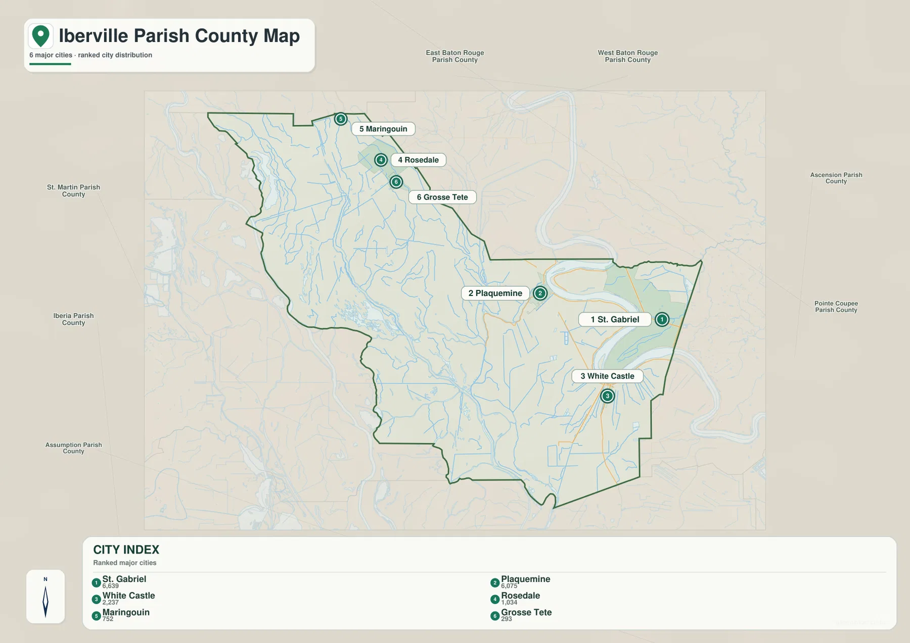
The city-distribution map simplifies the parish by removing most highway labels and emphasizing six major communities. Its index places St. Gabriel first, Plaquemine second, and White Castle third, followed by Rosedale, Maringouin, and Grosse Tete. Those rankings belong to the city index used for this map and should be treated as a map reference rather than a substitute for a current census table. The main value is geographic: it becomes easy to compare where the six communities sit inside the parish.
Three of the labeled places—St. Gabriel, Plaquemine, and White Castle—form a southern and central group around the Mississippi River corridor. Rosedale, Maringouin, and Grosse Tete form a separate northern group. The space between the two clusters is striking because the western interior contains far more waterways than named towns. For classroom slides, regional overviews, or a quick explanation of where the main communities are located, this cleaner city view can be easier to read than the more detailed road map.
The western half is threaded by the Grand River and named bayous
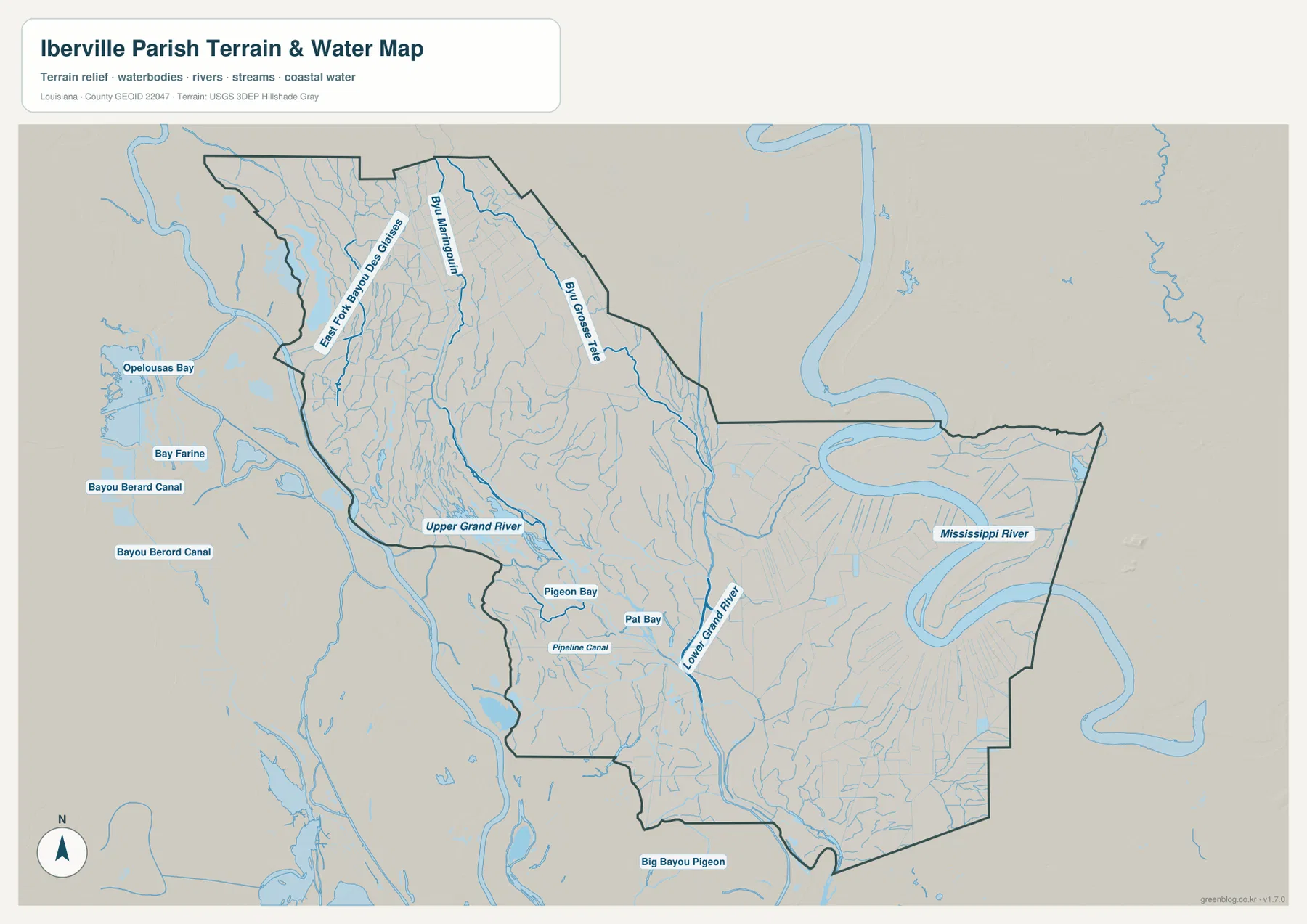
The terrain-and-water map changes the emphasis completely. On the northwest side, East Fork Bayou Des Glaises appears near the boundary, while Bayou Maringouin and Bayou Grosse Tete run through the northern interior. Upper Grand River becomes a major named feature farther south and west, and Lower Grand River continues toward the southeastern side of the western section. Between them are smaller named waters such as Pigeon Bay, Pat Bay, and Pipeline Canal, surrounded by many additional channels that are too minor to dominate the road map.
This pattern explains why Iberville Parish is often associated with the Atchafalaya Basin landscape. The official parish tourism site describes Iberville as a gateway to the basin, and the map supports that geographic context by showing a wide, water-rich western interior. Opelousas Bay, Bay Farine, and Bayou Berard Canal appear beyond the parish boundary to the west, helping show how Iberville fits into a much larger network of bayous and swamp waterways. The map is useful for orientation, but it is not a navigation chart, flood map, wetland-regulation map, or source of water-depth information.
One large river on the east, a maze of smaller waterways on the west
The eastern and western water patterns are visually very different. The Mississippi River appears as a single broad channel making large bends along the eastern part of Iberville Parish. By contrast, the western side is divided among Grand River reaches, bayous, bays, canals, and many narrow tributaries. That contrast is one of the best ways to understand the parish: the river corridor concentrates several of the better-known communities and roads, while the western interior is defined more by water than by urban development.
Near the southern edge, Big Bayou Pigeon is labeled below the parish outline, and the Lower Grand River system continues through a landscape with few large settlement labels. Looking only at Plaquemine or White Castle would therefore give an incomplete picture of Iberville Parish. The water map reveals how much of the parish’s western and southern geography is tied to lowland waterways. When paired with the road map, it becomes clear why the same parish can contain a busy Mississippi River corridor and a very different bayou-and-basin environment.
Choosing the clearest map for roads, communities, or waterways
For a general introduction to Iberville Parish, start with the parish map. It is the only supplied view that brings together the boundary, Plaquemine, St. Gabriel, White Castle, the northern communities, major highways, and the Mississippi River at the same time. It works well when the goal is to explain where places are and how the road network fits around the parish’s irregular shape.
The city-distribution map is better when the main question is where the six prominent communities are located relative to one another. The terrain-and-water map should be the first choice for Bayou Grosse Tete, Bayou Maringouin, Upper Grand River, Lower Grand River, Big Bayou Pigeon, or the wider Atchafalaya-side water network. Using all three together gives a balanced picture: roads explain movement, the city index simplifies settlement distribution, and the water map shows why the large western interior looks so different from the Mississippi River corridor.
The downloadable archive contains the original JPG files corresponding to the three maps shown in the article. Each image is 3638 × 2572 pixels, giving more room for zooming and printing than the WebP previews used on the page. The files are suitable for classroom material, presentations, regional reference, and personal projects, but they remain general-purpose maps. Legal boundary work, surveying, flood determination, engineering, and marine navigation require the appropriate official datasets and professional products.
Frequently Asked Questions
Why does Iberville Parish appear on both sides of the Mississippi River?
The Mississippi River bends through the eastern part of the parish, leaving Plaquemine on the west bank and St. Gabriel in the eastern section. The general map also shows LA 1 crossing the river north of Plaquemine, which makes the relationship between the two sides easier to understand. Places may look close on the map while still being separated by the river.
Which map is best for Grand River and Bayou Grosse Tete?
The terrain-and-water map is the best choice. It emphasizes Upper Grand River, Lower Grand River, Bayou Grosse Tete, Bayou Maringouin, Big Bayou Pigeon, and many smaller channels that are less prominent on the road-focused map. It is a general geographic reference and should not be used as a flood, depth, or navigation map.
Do the numbers on the city map show driving distances?
No. This city-index map ranks and locates St. Gabriel, Plaquemine, White Castle, Rosedale, Maringouin, and Grosse Tete; it does not display either driving distances or straight-line connector distances. Use current road and navigation information when planning an actual trip between the communities.
Map File Information
The ZIP contains the original high-resolution JPG files corresponding to the general parish map, city-distribution map, and terrain-and-water map shown in this article.
- Included Files: parish map JPG, city-distribution map JPG, terrain-and-water map JPG
Related Maps
Sources and references
- Visit Iberville — Our Parish — official tourism information on Plaquemine as the parish seat and the parish’s communities.
- Visit Iberville — Outdoors — official context for the Mississippi River, Atchafalaya Basin, and local waterways.
- Louisiana DOTD — Iberville Parish Map — official road, community, waterway, and parish-boundary reference.
- USGS National Hydrography — authoritative federal hydrography resources for streams and waterbodies.
- U.S. Census Bureau TIGER/Line — official geographic boundary and transportation data resources.
Green Map creates custom-edited map images using open geographic data sources such as geoBoundaries, Natural Earth, OpenStreetMap, and government open data. These maps are edited visual materials, not raw data files, and are provided for education, documents, presentations, and graphic reference.