Iberia Parish is one of those Louisiana places that changes character dramatically depending on which part of the map you are looking at. Around New Iberia, the page is filled with roads, rail lines, towns, and the familiar corridor toward Jeanerette. Follow the parish boundary east, however, and urban references give way to Grand Lake, winding waterways, wetlands, and a long reach toward the Atchafalaya Basin. The parish also includes a separate coastal island area to the south. The maps on this page make those contrasts easy to compare, and the matching high-resolution JPG files can be downloaded together in the ZIP box below. High-resolution map files are available for download in the section below.
New Iberia is the practical starting point. Louisiana’s official parish profile identifies it as the parish seat, while the supplied road map places it near the densest cluster of highways in the western part of the parish. Loreauville lies to the north, Jeanerette to the southeast, and Lydia appears farther south along the network of state routes. Beyond that populated western section, the outline stretches into a landscape where water occupies much more of the map than streets do. Understanding Iberia Parish therefore means looking at both the settled road corridor and the much broader water-and-coast geography.
Table of Contents
The New Iberia road cluster anchors the western parish
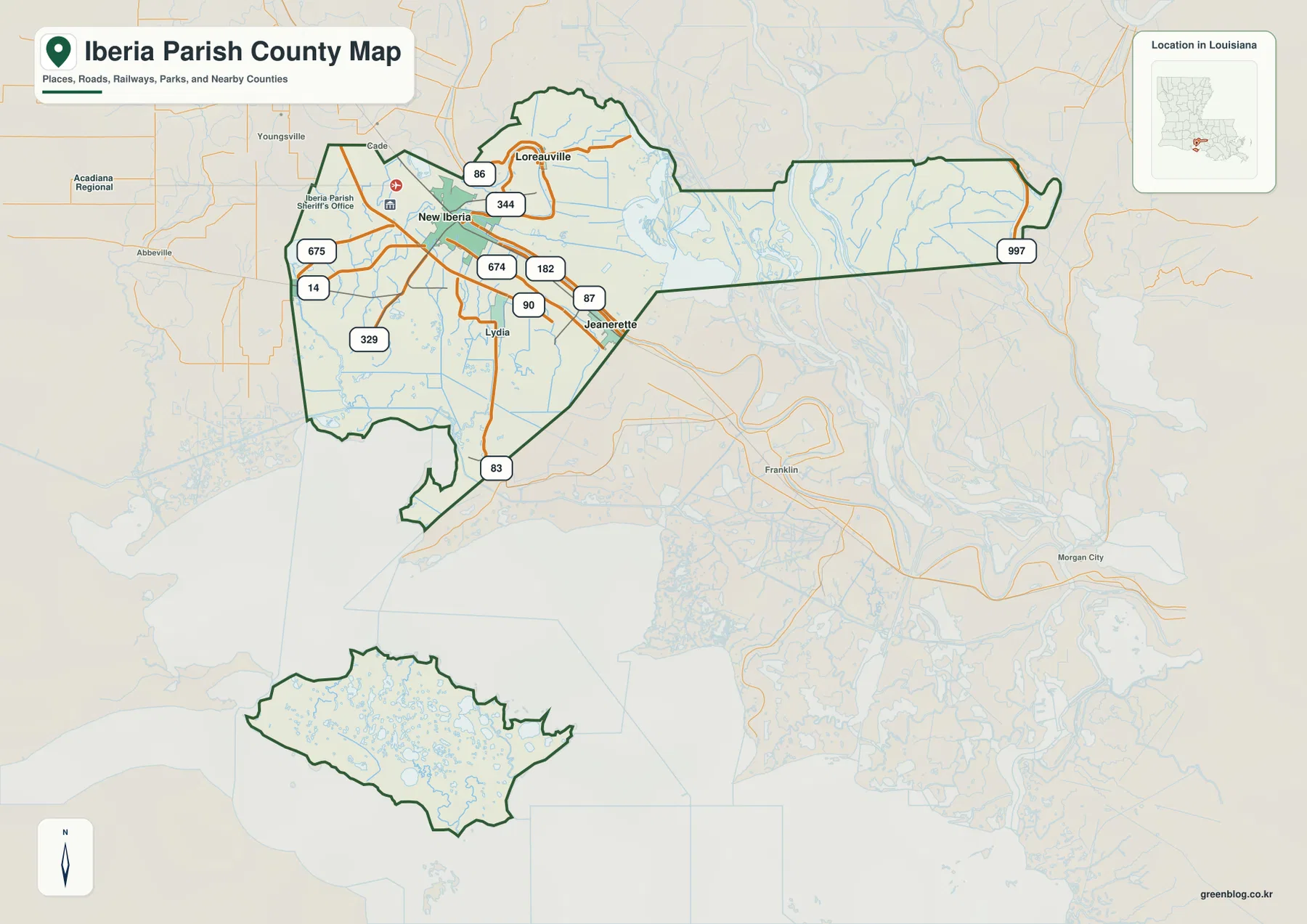
The general parish map is the best place to establish orientation because it combines the boundary, communities, major highways, rail lines, and selected waterways. New Iberia sits near the center of the western land section, with U.S. 90 passing just to the south before continuing toward Jeanerette. LA 182 follows the same broad southeast direction, while LA 14 heads west and several numbered state routes fan out toward Loreauville, Lydia, and smaller communities. The map makes it clear that this is the parish’s main road concentration.
Loreauville occupies a more northerly position, reached through the network around LA 86 and LA 344. Jeanerette lies southeast of New Iberia near U.S. 90 and LA 182, while Lydia is positioned farther south near LA 83. These roads are useful visual anchors even when a reader is not planning a drive: they show how the named places line up with one another and where the populated western section gives way to a less road-dense landscape. For current traffic, construction, or turn-by-turn travel, a live road service is still the appropriate source.
A parish outline shaped by lakes, wetlands, and a detached coastal island
The parish boundary is unusually informative in its own right. West of Grand Lake, the outline encloses the compact road-and-community area around New Iberia. From there, a long eastern reach extends across a much wetter landscape toward Grand Lake and Old River. Farther south, a detached polygon sits beyond the mainland across broad coastal water. Iberia Parish’s official hazard mitigation plan explains that much of the eastern area is water and cypress swamp and that the parish’s irregular boundaries extend through the Atchafalaya Basin; it also identifies Marsh Island as part of the parish.
That geography matters because a map focused only on New Iberia would give an incomplete impression of Iberia Parish. The parish is not simply the urban and rural land around its seat. It also reaches into large wetland and coastal environments that are visually separated from the road network. The outline on this page is useful for understanding that overall shape, but it should not be treated as a parcel survey, a property ownership map, or a source for legal boundary coordinates.
What the New Iberia connection map says—and what it does not
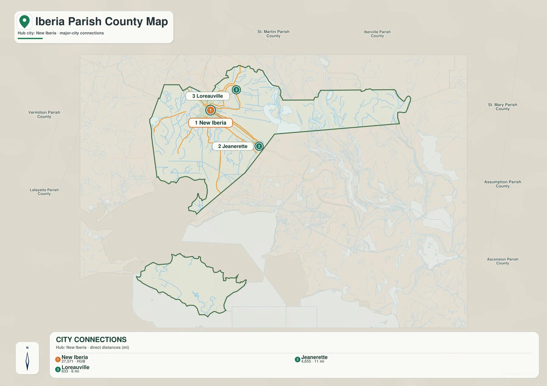
The city-connections map deliberately strips away much of the road detail and makes New Iberia the hub. Loreauville appears north of the hub and Jeanerette southeast of it, with simple connector lines showing direction and separation. The labels give Loreauville at about 6 miles from New Iberia and Jeanerette at about 11 miles. Those values are straight-line distances, not miles driven along a particular highway.
That distinction is especially important in southern Louisiana, where bayous, canals, bridges, and the shape of the road network can make an actual trip longer than a line drawn between two points. The connection map is most useful when a reader wants a quick geographic comparison: Which community is north of New Iberia? Which one lies farther away toward the southeast? It is not designed to estimate travel time, choose a route, or replace navigation software.
Bayou Teche ties the settled corridor to the parish’s water geography
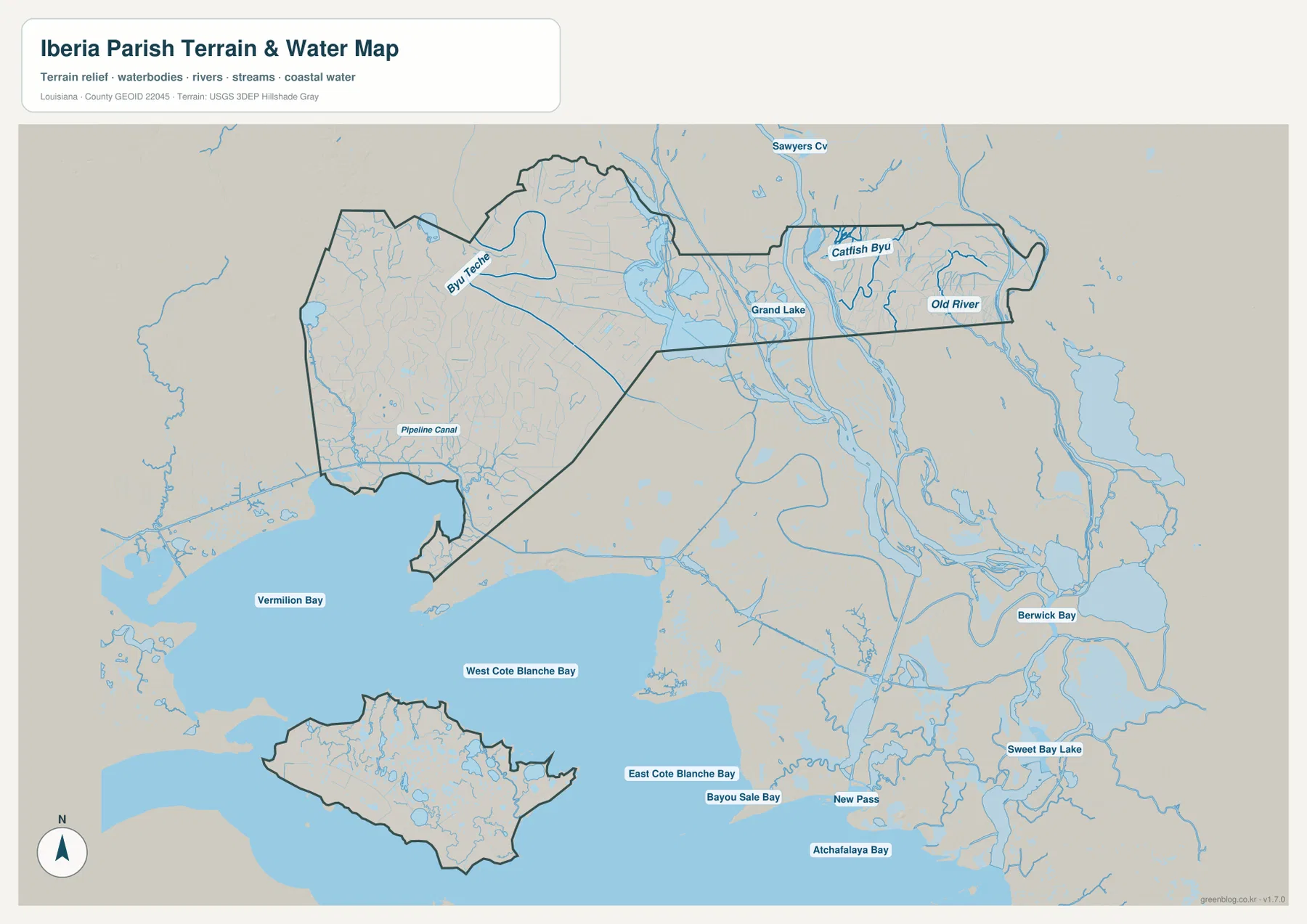
On the terrain-and-water map, Bayou Teche becomes one of the clearest named features in the western part of Iberia Parish. It runs through the same general landscape that contains New Iberia and Jeanerette, but the map removes most of the highway emphasis and reveals how many smaller channels and canals surround the settled corridor. Pipeline Canal is labeled farther southwest, while numerous smaller blue lines cross the low terrain between the road network and the coastal waters.
This view helps explain why a road map and a water map can feel so different even though they cover the same parish. The first organizes the area around communities and numbered routes; the second makes bayous, canals, lakes, and the broad low-relief terrain the dominant visual features. If the question is where U.S. 90 runs, use the general map. If the question is how Bayou Teche sits within the wider network of channels, the terrain-and-water map is far more useful.
Grand Lake and Old River define a very different eastern reach
Moving east across the water map, Grand Lake becomes the major reference point. Old River is labeled farther east, and Catfish Bayou appears north of the parish’s long eastern section. Here the pattern is almost the reverse of the New Iberia area: named roads and towns become scarce, while branching watercourses occupy most of the visible landscape. The neighboring Atchafalaya Basin context is also apparent in the maze of channels beyond the parish outline.
Readers should be careful not to assume that every waterbody shown in the surrounding basemap lies wholly inside Iberia Parish. The map provides context beyond the boundary so that the parish’s eastern reach can be understood in relation to adjacent waterways. It is a geographic reference, not a flood map, navigation chart, wetland permit map, or legal water-boundary document. More specialized questions require current data from the appropriate federal, state, or local agency.
Marsh Island sits among Vermilion and Côte Blanche coastal waters
The southern half of the terrain-and-water map provides the clearest picture of Iberia Parish’s coastal side. Vermilion Bay is labeled to the west, West Cote Blanche Bay and East Cote Blanche Bay span the middle, and Atchafalaya Bay appears farther east in the surrounding context. The detached parish section lies within that coastal setting and corresponds to Marsh Island, which the official parish hazard plan specifically identifies as part of Iberia Parish.
Inside the island outline, small ponds and channels are visible rather than a dense road network. That contrast reinforces a key point about the parish: its geography includes both a populated inland corridor and a substantial coastal wetland component. The map is excellent for showing relative position, but it does not supply water depth, tidal conditions, safe boating routes, or access rules. Anyone using the coastal waters for travel or recreation should consult current navigation and local management information.
Choosing a map for roads, community spacing, or coastal waterways
Each supplied map answers a different kind of question. The general parish map is the broadest reference because it combines the boundary with New Iberia, Jeanerette, Loreauville, Lydia, major highways, rail lines, and selected water features. It works well for a regional overview or whenever roads and communities need to appear together. The city-connections map is more selective and is useful when the main goal is to compare the direction and straight-line spacing of New Iberia, Loreauville, and Jeanerette without the visual weight of every highway label.
The terrain-and-water map is the strongest choice for the features that make Iberia Parish geographically unusual. Bayou Teche, Grand Lake, Old River, the coastal bays, and Marsh Island are much easier to distinguish there. Using the three views together prevents the western urban corridor from overshadowing the parish’s wetlands and coast, while also preventing the expansive water geography from hiding where most of the named communities and roads are concentrated.
The downloadable archive contains the original JPG versions corresponding to the three maps in the article. Each image is 3638 × 2572 pixels, so the files provide substantially more room for zooming, printing, classroom material, presentation slides, or detailed visual reference than the WebP previews in the article. They remain general reference maps, however. Surveying, legal boundary work, flood determination, engineering design, and marine navigation require purpose-built official datasets.
Frequently Asked Questions
Why does Iberia Parish have a long eastern extension and a separate southern section?
The parish extends well beyond the New Iberia road corridor into the wetland and water landscape toward the Atchafalaya Basin. Its official hazard mitigation plan describes an irregular boundary with extensive eastern water and cypress swamp and identifies Marsh Island as part of the parish. That is why the full outline includes both the long eastern reach and a detached coastal island section.
Are the 6-mile and 11-mile labels on the city map driving distances?
No. The city-connections map uses New Iberia as the hub and shows approximately 6 miles to Loreauville and 11 miles to Jeanerette as straight-line distances. A real drive follows the available road network and can be longer, so current navigation data should be used for route planning and travel time.
Which map is best for Bayou Teche, Grand Lake, and Marsh Island?
The terrain-and-water map is the most useful of the three for those features. It emphasizes Bayou Teche, Grand Lake, Old River, coastal bays, Marsh Island, and the dense network of smaller channels that are less prominent on the road-focused map. It is still a general geographic reference rather than a flood, survey, or navigation product.
Map File Information
The ZIP contains the original high-resolution JPG files corresponding to the general parish map, city-connections map, and terrain-and-water map shown in this article.
- Included Files: parish map JPG, city-connections map JPG, terrain-and-water map JPG
Related Maps
Sources and references
- State of Louisiana — Iberia Parish Profile — official parish-seat and community information.
- Iberia Parish Government — local government information, parish overview, and links to official maps and GIS resources.
- Louisiana DOTD — Official Iberia Parish Map — detailed state road, community, waterway, and boundary reference.
- Iberia Parish Hazard Mitigation Plan — official parish planning document describing the eastern wetlands, irregular boundary, and Marsh Island.
- USGS National Hydrography — authoritative hydrography resources for streams and waterbodies.
- U.S. Census Bureau TIGER/Line — official geographic boundary and transportation data resources.
Green Map creates custom-edited map images using open geographic data sources such as geoBoundaries, Natural Earth, OpenStreetMap, and government open data. These maps are edited visual materials, not raw data files, and are provided for education, documents, presentations, and graphic reference.