Knox County lies in the mountains of southeastern Kentucky, where Barbourville serves as the clearest reference point and smaller places such as North Corbin, Artemus, and Flat Lick sit along winding valleys and roads. The county borders other mountain counties in several directions, so the road network makes more sense when it is viewed together with streams and relief rather than as a simple grid. This page explains the county through the features visible on the supplied maps.
High-resolution JPG versions of the maps are available in the download box below. The web previews are convenient for quick orientation, while the original files are better for enlarging small highway numbers, creek names, and ridge details around Barbourville and the Cumberland River basin.
Table of Contents
Barbourville is the main road reference in a county of winding mountain routes
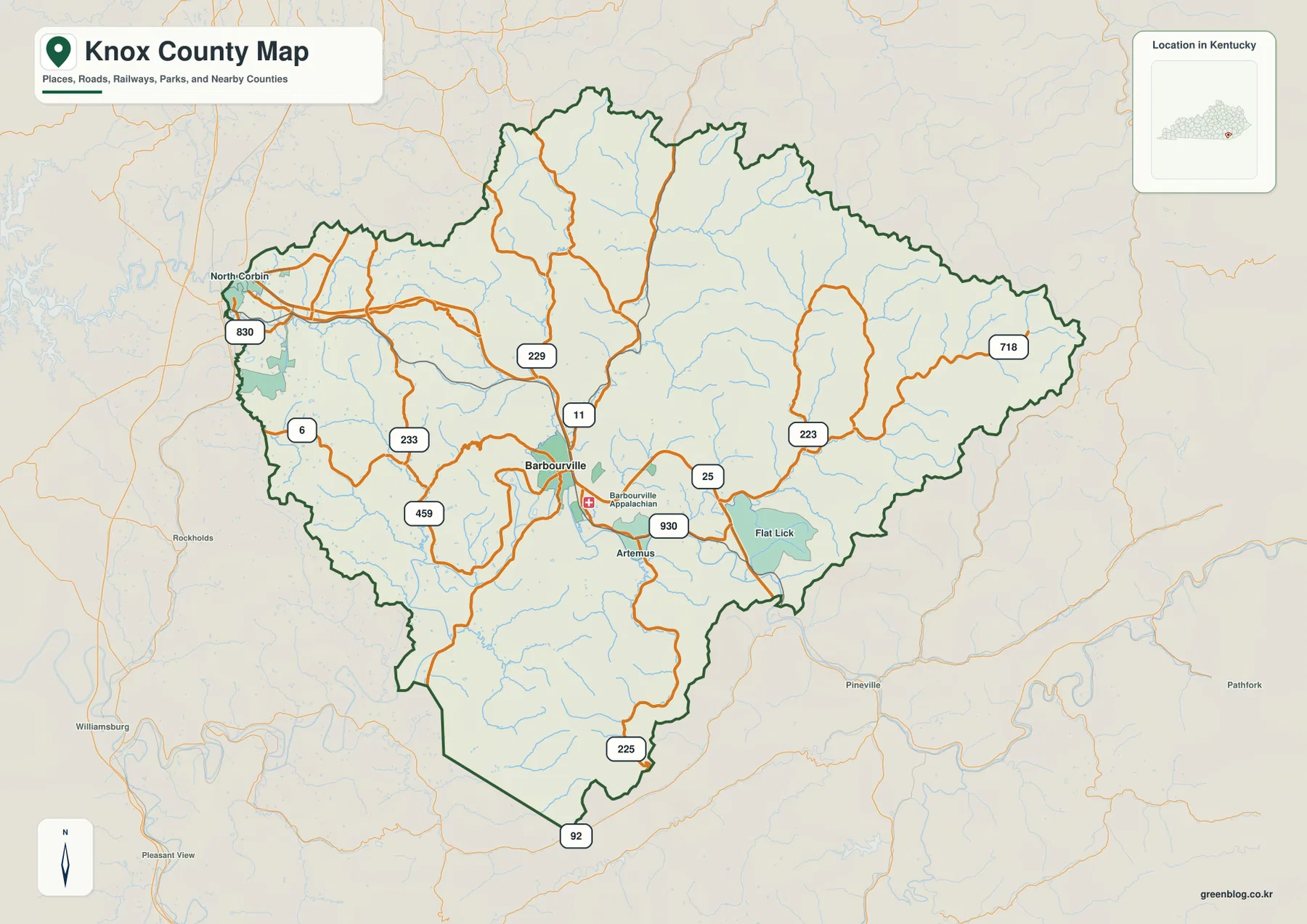
On the county map, Barbourville sits a little south of the county center and stands out as the main junction for local travel. Kentucky Route 11 runs through the central part of the county, while Route 25 heads east toward Flat Lick. Routes 6, 233, 229, and 830 spread toward the west and northwest, and Routes 223 and 718 reach into the eastern ridges. Farther south, Routes 225 and 92 lead toward the pointed southern part of the county boundary.
North Corbin appears near the northwestern edge, separated from Barbourville by a network of smaller roads and valleys. Artemus is close to Barbourville on the southeast side, while Flat Lick is farther east. These places are not arranged on a broad plain; the routes bend repeatedly as they cross or follow mountain hollows, so road numbers and stream locations are often more useful than compass direction alone.
The county outline is irregular as well. The eastern side extends into a narrow mountain section, and the southern boundary drops into a pronounced point. That shape, together with the ridged terrain, means a nearby place in straight-line distance may still require a longer drive around high ground or through a different valley.
Barbourville stands alone as the major city marker
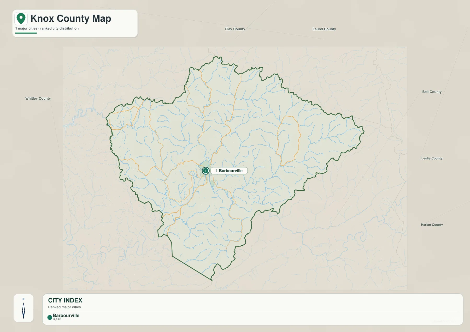
The city map highlights only one major city: Barbourville. The city index printed on the supplied map shows 3,146, which is best treated as a reference value from this map rather than a claim about the latest population estimate. Its main value here is showing that Barbourville is the clearest urban anchor inside the county.
Other named places still matter for orientation. North Corbin, Artemus, and Flat Lick appear on the general county map, and Barbourville Appalachian Regional Hospital provides another recognizable point near the center. Starting with Barbourville and then switching to the road map is an effective way to understand where the smaller communities sit among the valleys.
Knox County’s official website describes the county as part of the mountains of southeastern Kentucky, and Barbourville tourism materials connect the area with the Wilderness Road, Boone Trace, and other regional heritage. Those references fit the geography visible on the maps: settlement and travel routes are concentrated in a landscape where ridges strongly shape movement.
Cumberland River tributaries divide the county into narrow valleys
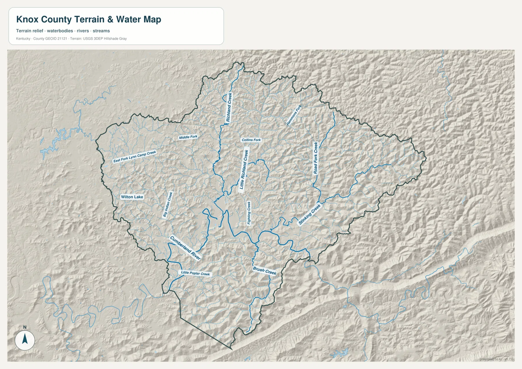
The Cumberland River is the largest named waterway on the terrain-and-water map. It curves through the southwestern part of Knox County and passes through lower terrain south of Barbourville. Little Richmond Creek and Richmond Creek descend through the central area, while Fighting Creek approaches from the east. Together they show how stream valleys break the county into many narrow ridges and hollows.
Farther east, Road Fork Creek and Stinking Creek extend through long mountain valleys, with Hammons Fork labeled in the northeast. The western half includes East Fork Lynn Camp Creek, Big Indian Creek, and Wilton Lake, while Middle Fork and Collins Fork appear farther north and central. Brush Creek and Little Poplar Creek occupy the southern part of the county near the Cumberland River lowlands.
This map is intended for geographic reference, not for flood prediction, real-time water conditions, navigation, or parcel boundaries. Its practical strength is showing why many roads curve with valleys instead of cutting directly across ridges. For current flood or water-level information, use the appropriate live agency products.
Elevation rises from 271 to 705 meters across the ridge country
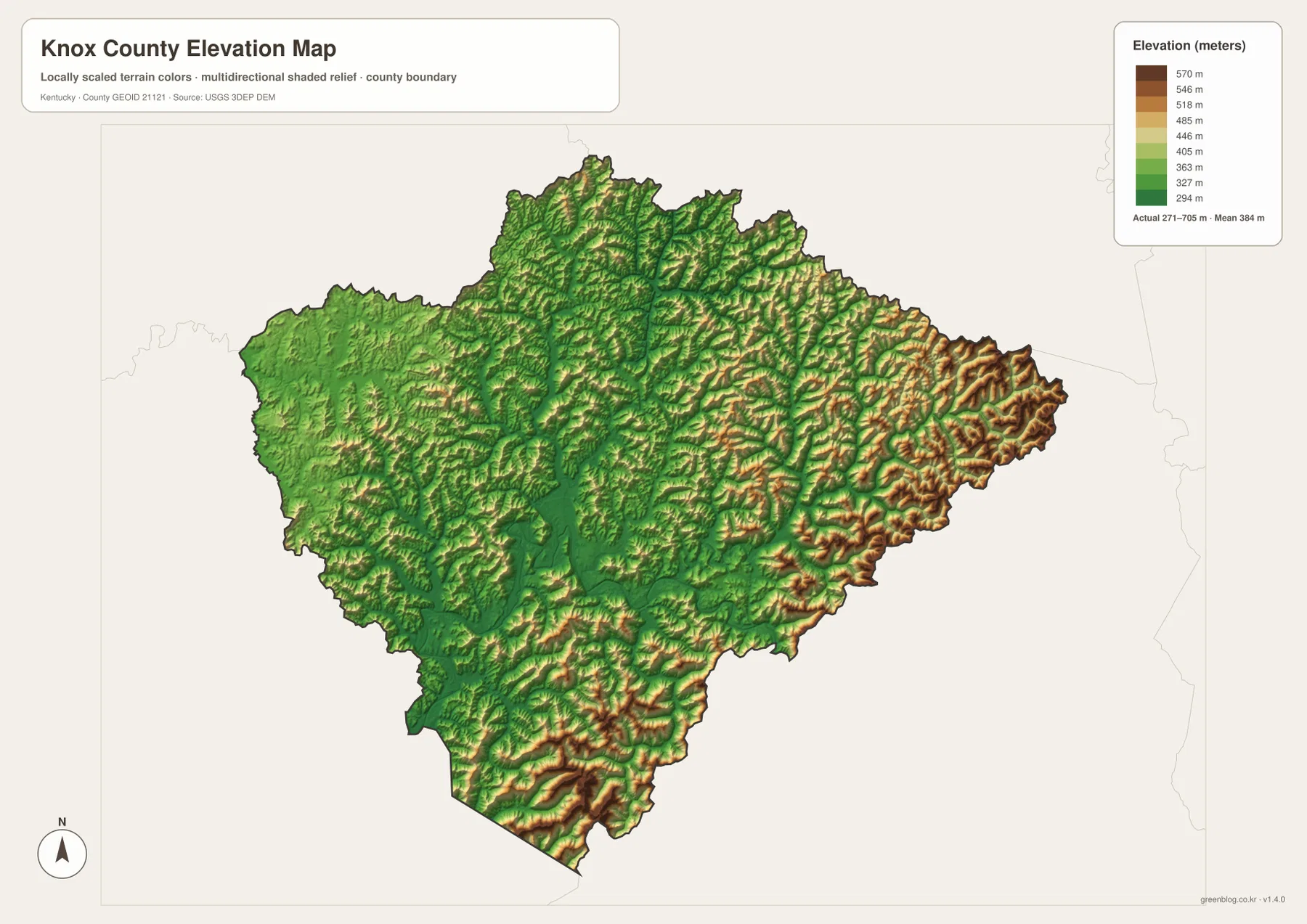
The elevation map reports an actual range of about 271 to 705 meters, with a mean of 384 meters. Lower green terrain follows the Cumberland River and major tributary valleys, while tan and brown ridges become especially prominent in the east and south. The roughly 434-meter range is large enough to make topographic differences obvious even at county scale.
The eastern tip contains closely packed high ridges, and the pointed southern section also rises sharply above nearby valleys. Around Barbourville and the Cumberland River, lower terrain forms broader corridors where roads and settlement are more concentrated. The North Corbin side is generally lower than the rugged eastern edge, although it remains broken by smaller ridges and drainage lines.
Comparing the water and elevation maps is especially useful. Stinking Creek, Richmond Creek, and Fighting Creek occupy lower corridors that correspond with green bands on the elevation image. The elevation surface is generalized for county-scale comparison, so survey, construction, engineering, and exact parcel-elevation work should rely on original USGS data or professional measurements.
Use Barbourville first, then follow the valley that matches your destination
For practical orientation, begin with Barbourville and identify which valley contains the destination. North Corbin is reached toward the northwest side, Flat Lick lies to the east near Routes 25, 223, and 718, and the southern part of the county is reached through roads such as Routes 225 and 92. In this terrain, two points that look close on a simple outline can require a much longer route because a ridge stands between them.
The official Knox County site presents the area as a southeastern Kentucky mountain community, while Barbourville tourism highlights Dr. Thomas Walker State Historic Site, Boone Trace, and Wilderness Road history. These destinations are easier to place when the road map is used together with the terrain image, because the valleys explain why historic and modern travel corridors follow certain paths through the county.
For a quick road-and-boundary check, the general county map is the best first file. The city map is useful when the goal is simply to locate Barbourville, the terrain-and-water map is better for Cumberland River and creek names, and the elevation image is the clearest choice for comparing ridge height with valley floors. Using two maps side by side often gives a clearer answer than relying on one layer alone.
High-resolution JPG files make the small labels easier to inspect
Knox County contains many small roads and named streams, so the original JPG files are useful when the web preview becomes crowded. Enlarging the image makes eastern route numbers such as 223 and 718 easier to follow and gives more room to read names such as Richmond Creek, Stinking Creek, and Road Fork Creek.
For printing, start with the county map for roads and place names, then keep the water and elevation maps nearby for terrain context. The files are large enough for detailed reference and can be useful for classroom work, trip planning, or personal geographic study without relying on a tiny browser preview.
Frequently Asked Questions
What is the easiest place to use as a reference point in Knox County?
Barbourville is the easiest reference point. It lies near the central road network, several state routes meet around it, and the Cumberland River valley is nearby. Once Barbourville is located, North Corbin can be placed to the northwest and Artemus and Flat Lick to the east and southeast.
Which map is best for Stinking Creek and the Cumberland River?
The terrain-and-water map is the best choice. It labels the Cumberland River, Stinking Creek, Richmond Creek, Road Fork Creek, Fighting Creek, Brush Creek, and Wilton Lake. Pairing it with the elevation map also shows how those waterways occupy lower valleys between higher ridges.
Can the 271–705 meter elevation map be used for surveying or engineering?
No. It is a county-scale reference map intended to show relative terrain differences. Exact parcel elevation, engineering design, construction, or professional surveying should use current source data and site-specific measurements.
Map File Information
Download the Knox County boundary, city, terrain-and-water, and elevation maps as the original high-resolution JPG files.
- Included Files: county map, city map, terrain and water map, elevation map
Related Maps
Sources and References
County and local context was checked with the official Knox County website and City of Barbourville tourism site. Boundary and road data can be referenced through U.S. Census Bureau TIGER/Line, waterways through USGS National Hydrography, and elevation data through the USGS 3D Elevation Program.
Green Map creates custom-edited map images using open geographic data sources such as geoBoundaries, Natural Earth, OpenStreetMap, and government open data. These maps are edited visual materials, not raw data files, and are provided for education, documents, presentations, and graphic reference.