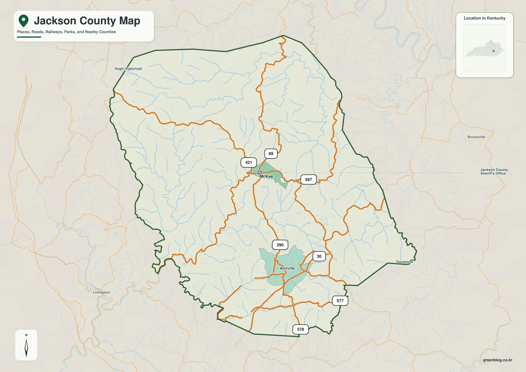
Jackson County sits in the mountainous part of eastern Kentucky, where McKee provides the clearest reference point among winding roads, narrow stream valleys, and closely spaced ridges. U.S. 421 and KY 89 pass near McKee, but many local routes bend repeatedly as they follow lower ground between the hills. The maps on this page connect those roads with Annville, the Rockcastle River forks, named creeks, and the county’s large elevation changes. High-resolution JPG originals are also available in a ZIP for printing or close inspection. High-resolution map files are available for download in the section below.
McKee is slightly north of the county’s visual center, yet it is the easiest place to start because several important routes meet nearby. Annville provides a second place reference farther south. Around the county, Rockcastle, Laurel, Clay, Lee, Owsley, Estill, and Madison counties help establish Jackson County’s position within the broader eastern Kentucky region. Once McKee and U.S. 421 are located, the rest of the road network becomes much easier to follow.
Table of Contents
Start with McKee to follow the county’s curving mountain roads
U.S. 421 and KY 89 form the most useful road reference around McKee. KY 587 heads east from the area, while KY 290 and KY 30 appear farther south around Annville. KY 577 and KY 578 reach additional valleys in the southern and southeastern part of the county. These roads rarely form long straight corridors. Their curves make more sense when viewed as routes threading between ridges rather than lines crossing an open plain.
The northern part of Jackson County contains broad areas with fewer prominent route labels, while the southern half shows more connections around Annville and nearby valleys. To the west, routes approach the Rockcastle County and Madison County sides of the boundary; to the southwest, the county turns toward Laurel County. For travel planning or a regional presentation, it is usually clearer to begin with U.S. 421 and then move outward to the state routes closest to the destination.
The county outline itself is irregular, especially along the western, southwestern, and eastern sides. That shape reinforces the impression of a county defined by ridges and hollows rather than a simple grid. A short straight-line distance on the page may require a longer drive because a route has to stay within one valley before crossing into another.
One primary city marker highlights how rural the county remains
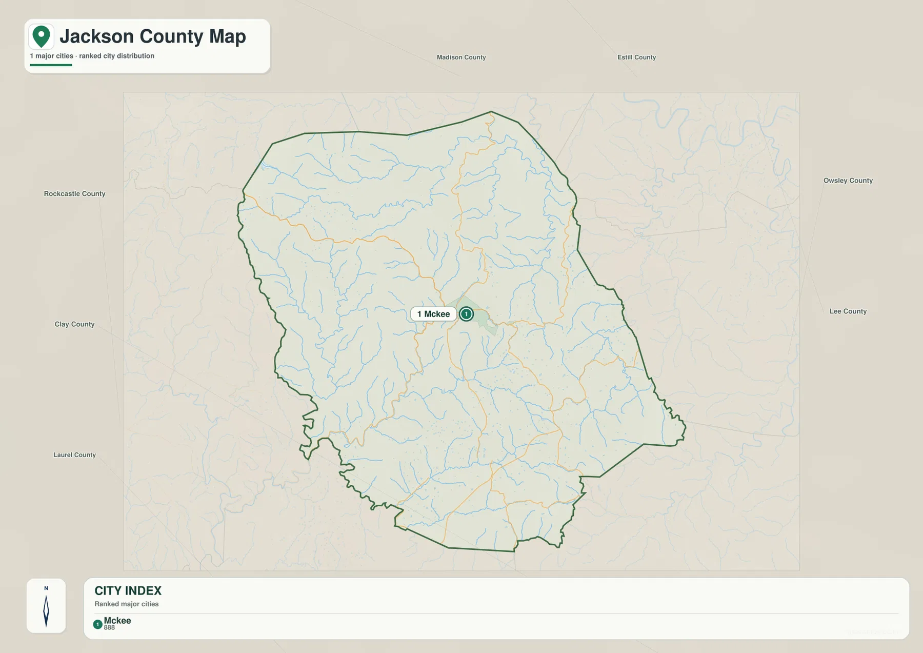
The city-distribution file selects McKee as the only ranked major city and shows a reference value of 888. That number is a map-production reference rather than a claim about the latest official population. Its value here is comparative: McKee stands alone as the clearest urban marker inside a county otherwise dominated by small communities, rural roads, forested slopes, and mountain valleys.
Annville appears on the broader county map but not in the ranked city index. That difference is useful rather than contradictory. McKee works well as the primary orientation point, while Annville helps locate the southern road network. Starting with McKee, then moving south along U.S. 421 and the KY 30–290 area, provides a straightforward way to organize places that might otherwise seem scattered across the mountainous terrain.
Kentucky Tourism describes McKee as a Trail Town in the Daniel Boone National Forest area and points visitors toward the Sheltowee Trace National Recreation Trail and other outdoor activities. Those recreation routes are not all drawn on the county map, so official trail and park resources should be used for trip planning. Still, the tourism context fits what the county maps show: one small central community serving a broad landscape of ridges, creeks, and rural roads.
Rockcastle River forks occupy the low corridors between ridges
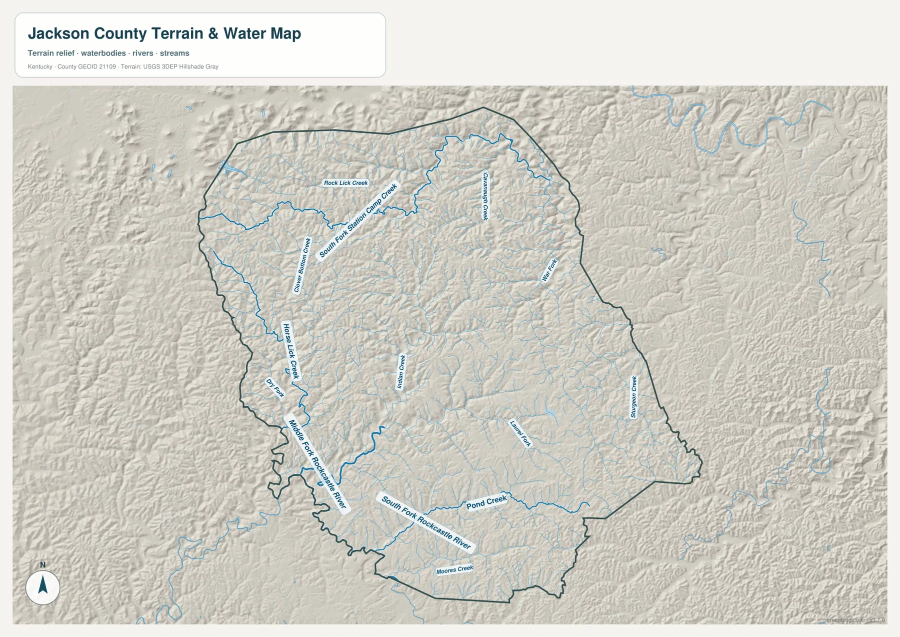
Jackson County is not organized around one large river running through its center. Instead, several river forks and creeks occupy separate valleys. The Middle Fork Rockcastle River is prominent in the southwest, while the South Fork Rockcastle River crosses the southern part of the county. Their valleys form some of the longest low corridors visible against the surrounding shaded relief.
Horse Lick Creek and Clover Bottom Creek lie toward the west, while Rock Lick Creek and South Fork Station Camp Creek appear farther northwest. Indian Creek marks part of the central area. War Fork and Sturgeon Creek occupy eastern valleys, with Laurel Fork farther southeast and Pond Creek and Moores Creek in the south. The number of named waterways explains why neighboring communities can sit in different drainage valleys even when they are not far apart in straight-line distance.
This is a county-scale reference for the location of streams and valleys. It should not be used as a flood-zone map, parcel survey, real-time river gauge, or road-condition source. In steep terrain, a creek and road may appear close together while local crossings, banks, and access conditions remain important. Current hydrologic questions should be checked against USGS resources and the appropriate local or state agency data.
A 198 to 495 meter range explains the ridge-and-hollow landscape
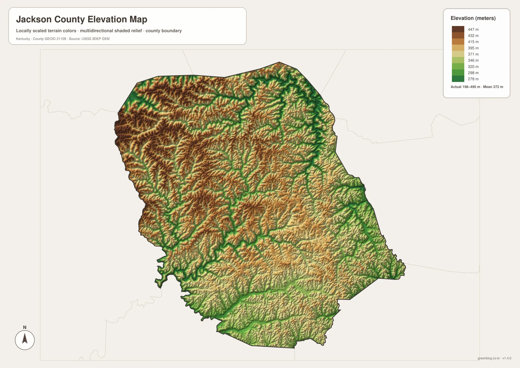
The elevation data reports an actual range of about 198 to 495 meters, with a mean of 372 meters. Higher terrain covers much of the west and northwest, while lower colors thread through stream valleys. In the south and southwest, the Rockcastle River system creates longer low corridors that contrast sharply with the ridges on either side.
Comparing elevation with the water network also explains the road geometry. The Middle and South Forks of the Rockcastle River occupy lower ground, and nearby ridges rise quickly above them. Similar relationships appear around War Fork and Sturgeon Creek in the east. Roads often bend because they stay within the lower valley floor for as long as possible before crossing a ridge or moving into a neighboring drainage.
The mean elevation of 372 meters is only a countywide summary. Jackson County contains low valley floors near the bottom of the mapped range and ridge tops well above 400 meters. The image is appropriate for comparing relief at county scale, but exact site elevation, construction design, engineering, and legal survey work require the underlying USGS elevation data or professional field measurements.
Roads, water, and relief tell one connected story around McKee
The most useful way to understand Jackson County is to move outward from McKee rather than treat each map as a separate subject. From McKee, U.S. 421 leads toward Annville and the southern part of the county. The nearby state routes branch into valleys, while the Rockcastle River forks and smaller creeks occupy much of the lower ground. Elevation then explains why the road network curves so often and why communities tend to follow valleys instead of forming a broad urban grid.
For a school project or regional presentation, McKee can serve as the first label, followed by U.S. 421 and Annville. Adding the Rockcastle River forks and a few major creeks gives the landscape a clear hydrologic framework. Finally, the 198–495 m elevation range shows how strongly the ridges separate neighboring valleys. This sequence describes the county as a place rather than simply listing map products.
The WebP images are convenient for on-screen viewing. When small road numbers, creek names, or labels need to be enlarged, the ZIP below contains high-resolution JPG originals. The files cover county roads and boundaries, the city reference, water features, and elevation, so you can choose the image that best fits a printout, presentation, or local geography project.
Frequently Asked Questions
What is the easiest place to use as an orientation point in Jackson County?
McKee is the best starting point. U.S. 421 and KY 89 pass nearby, and the city-distribution file selects McKee as the only ranked major city. Once McKee is located, Annville to the south and the surrounding state routes are much easier to place.
Where should I look for the Rockcastle River forks and named creeks?
Start with the Middle Fork and South Fork Rockcastle River, then compare Horse Lick Creek, Indian Creek, War Fork, Sturgeon Creek, and Pond Creek. The elevation image adds useful context because these waterways generally occupy lower valleys between the surrounding ridges.
Can the 198–495 m elevation image be used for surveying or engineering?
No. It is intended for county-scale comparison of relative elevation and terrain form. Precise site elevations, construction design, engineering work, and legal measurements require the underlying USGS data or professional survey information appropriate to the project.
Map File Information
The ZIP contains high-resolution JPG originals for Jackson County, suitable for printing and close inspection of road, city, water, and elevation information.
- File Type: JPG
Related Maps
Sources and References
Local information is available from the official Jackson County website, while recreation context around McKee is described by Kentucky Tourism’s McKee Trail Town page. Boundary and road data can be checked through U.S. Census Bureau TIGER/Line, hydrography through USGS National Hydrography, and elevation data through the USGS 3D Elevation Program.
Green Map creates custom-edited map images using open geographic data sources such as geoBoundaries, Natural Earth, OpenStreetMap, and government open data. These maps are edited visual materials, not raw data files, and are provided for education, documents, presentations, and graphic reference.