Henry County sits in north-central Kentucky with a settlement pattern that becomes easier to understand once Eminence and New Castle are used as the first two reference points. Eminence is the largest place emphasized on the supplied city map, while New Castle is marked with the Henry County Courthouse and serves as the administrative center. Campbellsburg anchors the northwest, and the road network spreads through rolling farmland and short creek valleys. The maps on this page can be reviewed online, and all four high-resolution JPG versions can be downloaded together in a ZIP archive. High-resolution map files are available for download in the section below.
The county does not revolve around one single highway or river. Interstate 71 and U.S. 42 touch the western side, U.S. 421 crosses the south-central part, and state routes such as KY 55, 146, 157, 193, and 202 connect the interior. Water follows a different pattern: Little Kentucky River occupies the southwest, Drennon Creek cuts through the east, and smaller creeks break the uplands into many narrow valleys. Reading the town, water, and elevation layers together gives Henry County a much clearer shape than a place-name list alone.
Table of Contents
Eminence and New Castle form the clearest road-and-town core
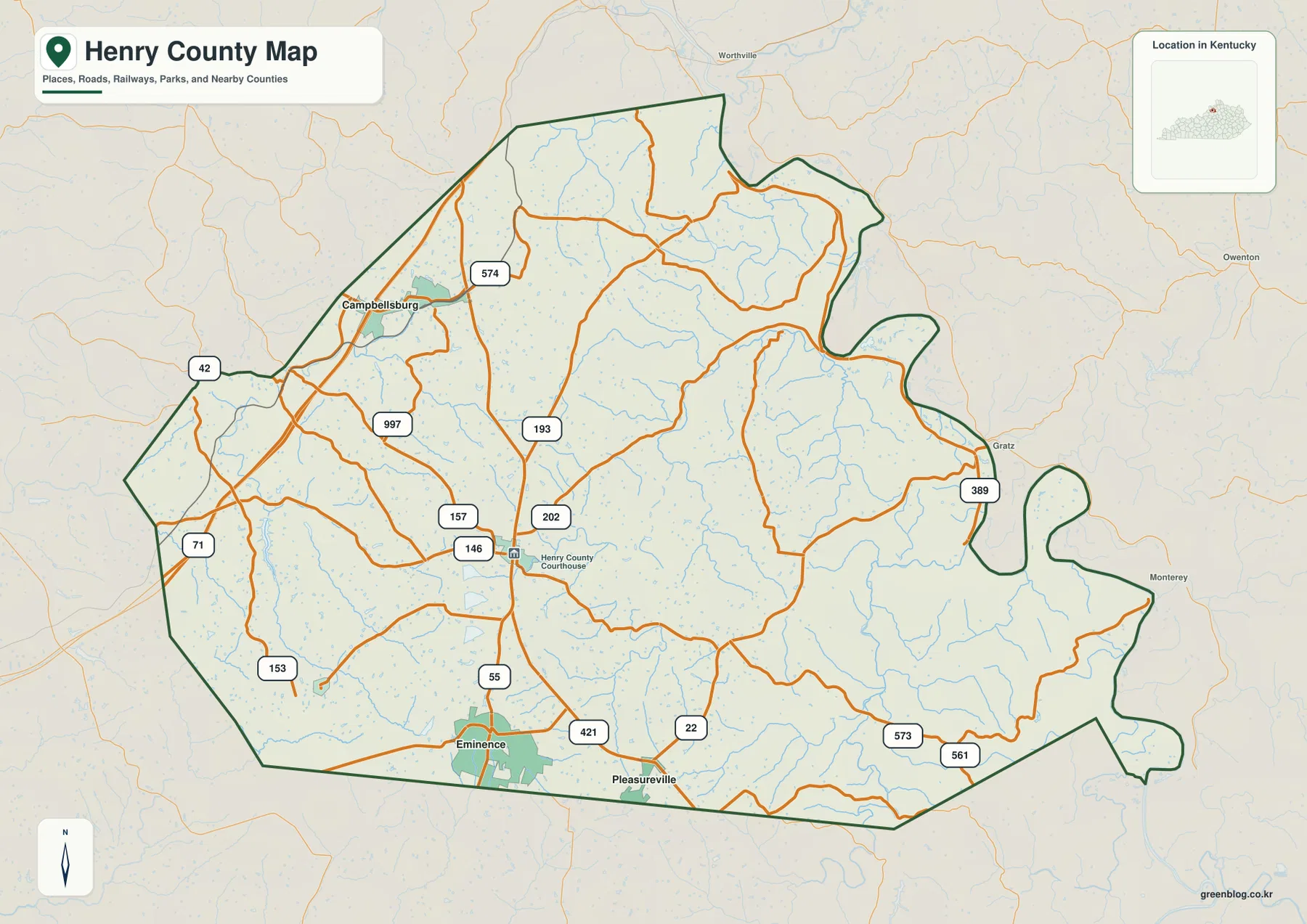
The general county map places Eminence near the southern edge where KY 55 and U.S. 421 are close together. New Castle lies to the north and is surrounded by a cluster of state routes, including KY 146, 157, and 202. This creates a recognizable south-central core even though the county remains largely rural outside the towns. The local roads bend frequently rather than forming a rigid grid, a pattern that matches the rolling surface shown in the terrain layers.
Campbellsburg is a different kind of reference point. It sits in the northwest near U.S. 42, KY 574, and KY 997, with Interstate 71 along the western side of the county. Farther south, KY 71 and KY 153 appear near the southwest boundary. On the eastern half, routes such as KY 389, 573, and 561 become more prominent, and the road lines follow narrower valleys and more irregular terrain.
New Castle is especially useful when orienting the map because the courthouse label identifies the county seat area. Eminence, by contrast, stands out as the larger population center on the city index. Pleasureville lies near the southern boundary along the U.S. 421 and KY 22 area, while Smithfield marks the far southwestern side. Together, these places show that Henry County’s population is concentrated more strongly in the west and south than in the deeply indented eastern half.
Five mapped towns show a west-and-south settlement pattern
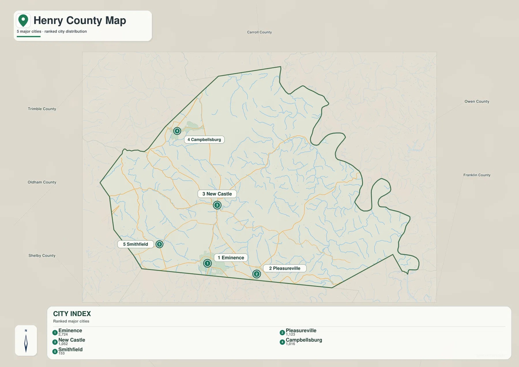
The city map strips away much of the road detail and ranks five places. Its reference values are Eminence 2,724, Pleasureville 1,123, New Castle 1,052, Campbellsburg 1,016, and Smithfield 153. These figures are useful for comparing the scale of the places shown on this particular map; anyone needing the latest official population estimate should check current U.S. Census Bureau data rather than treating the map index as a live count.
Eminence and Pleasureville sit close to the southern boundary, with New Castle just north of them. Campbellsburg is separated to the northwest, and Smithfield lies near the southwestern edge. The east and northeast contain no city markers of comparable size on this map. That imbalance explains why the general map feels busier around the western and southern road network while the eastern half is dominated by creek valleys and winding local routes.
The surrounding county labels add regional context. Carroll County is to the north, Trimble and Oldham counties are to the northwest and west, Shelby County is to the southwest, and Owen and Franklin counties lie to the east. Henry County therefore sits between the Louisville-side transportation network to the west and the more dissected uplands toward the east, while its towns remain clustered closer to the western and southern approaches.
Little Kentucky River and Drennon Creek organize different sides of the county
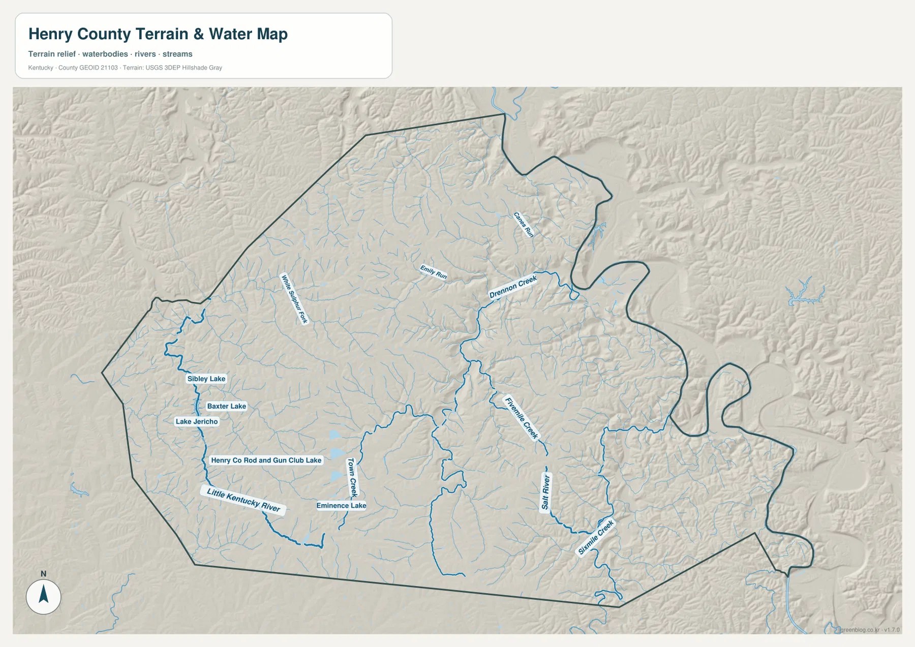
On the terrain-and-water map, Little Kentucky River is one of the strongest features in the southwest. Several small water bodies appear nearby, including Sibley Lake, Baxter Lake, Lake Jericho, and Henry Co Road and Gun Club Lake. Twin Creek and Eminence Lake add more water features near the southern part of the county. This combination shows that the Eminence side of Henry County includes a web of short tributaries and small impoundments rather than a single dominant channel.
The eastern half is organized around Drennon Creek and a separate group of tributaries. Emily Run and Caney Run appear to the north, while Franklinton Creek runs through the southeast. Salt River and Sixmile Creek are also labeled farther south. The relief background makes these channels especially informative because the streams occupy narrow lower corridors between short ridges, producing a much more dissected appearance than the broader western uplands.
White Sulphur Fork is labeled in the northwest and adds another drainage thread to the map. Taken together, these waterways show a county divided among many small valleys rather than one river valley that controls everything. The water map is designed for geographic reference only; it is not a flood-hazard map, parcel map, or navigation chart. Flood risk, property boundaries, and water-safety decisions require current specialized sources.
A 132–292 m elevation range separates western uplands from eastern creek valleys
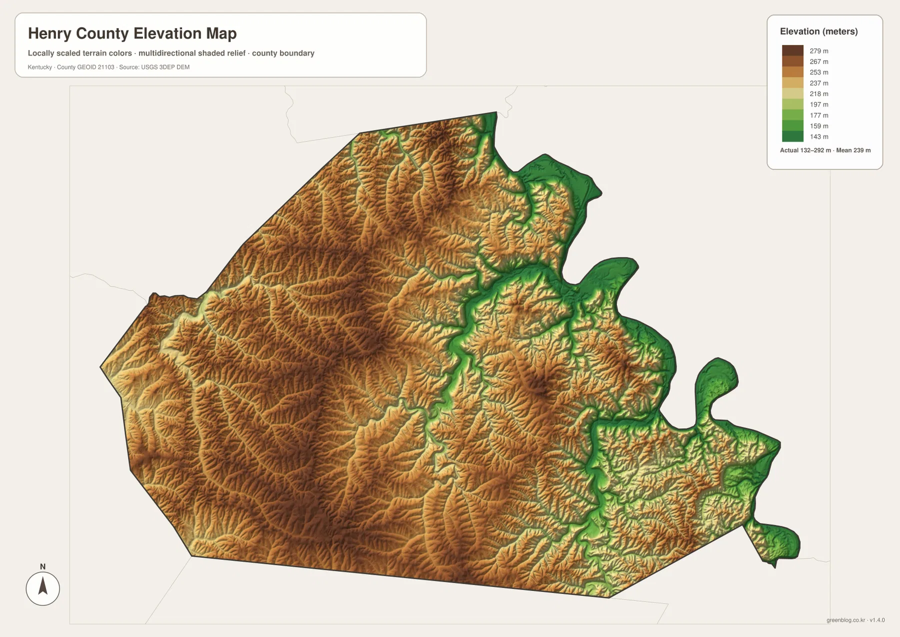
The elevation map reports an actual range of about 132 to 292 meters, with a mean elevation of 239 meters. Brown and tan tones cover broad parts of the west and southwest, indicating higher rolling uplands around the Campbellsburg-to-Eminence side of the county. Short ridges also continue across the north, so Henry County is not a flat agricultural plain even where roads and fields appear relatively open on the general map.
Lower green corridors are more common in the east and northeast, especially along the Drennon Creek system. Similar lower bands appear around Salt River and Sixmile Creek in the southeast. When the water and elevation maps are viewed side by side, many named streams line up with these lower green corridors. That relationship makes it easier to understand why eastern roads curve and branch as they follow valley floors instead of crossing ridges directly.
The mean value of 239 meters is only a countywide summary. Local relief comes from repeated short ridges and narrow drainage cuts, so the ground can change quickly over a short distance. This map is a generalized county-scale elevation reference, not a survey product. Exact elevations for a building site, engineering project, or legal purpose should come from authoritative USGS data or professional surveying.
The rural county pattern links western highway access with eastern creek valleys
Henry County’s official website describes a community that has kept a rural atmosphere and agricultural heritage while remaining close to larger cities. The supplied maps fit that description. Eminence and New Castle provide compact town centers, but much of the space between them and the county edges is filled with local roads, creeks, fields, and rolling ridges. Campbellsburg provides the clearest connection to the western interstate corridor, while the eastern side feels more enclosed by drainage valleys.
The county boundary itself is unusually irregular in the east and northeast. Several lobes and inward bends create a shape that is far more complicated than a rectangle. The road and water layers help explain why that outline matters: local routes and streams repeatedly approach those boundary bends, and nearby labels such as Gratz and Monterey show where Henry County meets communities just outside its limits.
For regional orientation, the maps work best when their different strengths are used together. The general map answers where the towns and roads are, the city layer simplifies the settlement hierarchy, the water layer explains the creek network, and the elevation layer shows why those creeks and roads follow particular corridors. Henry County’s local character comes from the overlap of those features rather than from a single landmark.
Choose the file by whether you need roads, towns, water, or relief
Use the general county map when the task is to locate Eminence, New Castle, Campbellsburg, U.S. 421, U.S. 42, KY 55, and the surrounding county boundaries on one page. It keeps the most place and road information together. The city map is cleaner when the goal is simply to show where the five ranked towns sit relative to one another without the full road network competing for attention.
Use the terrain-and-water map when Little Kentucky River, Drennon Creek, Salt River, Sixmile Creek, or the local lakes are the main subject. Pair it with the elevation map when you want to compare a named creek with the lower valley it occupies or see how the western uplands differ from the eastern drainage corridors. Neither map replaces live hydrologic information, flood studies, or survey-grade elevation data.
The WebP images on the page are sized for quick online viewing. The ZIP archive contains the high-resolution JPG originals, which are better suited to zooming in on smaller route numbers, reading creek labels, printing, or placing the maps side by side. Comparing the general map with the water map is especially useful for seeing how roads follow valleys, while the water and elevation pair makes the county’s relief much easier to compare.
Frequently Asked Questions
Which two places are the best starting points for reading Henry County?
Eminence and New Castle are the most useful pair. Eminence is the largest place on the supplied city index and stands out in the southwest, while New Castle is marked with the Henry County Courthouse and provides an administrative reference near the center-west. Once those two are located, Campbellsburg, Pleasureville, and Smithfield are easy to place around them.
Which map is best for Little Kentucky River and Drennon Creek?
The terrain-and-water map is the best choice because it labels Little Kentucky River in the southwest and Drennon Creek in the east, along with Franklinton Creek, Salt River, Sixmile Creek, and several small lakes. Pairing it with the elevation map also shows how those waterways occupy lower corridors between the county’s rolling ridges.
Can the Henry County elevation map be used as survey data?
No. It is a county-scale reference surface showing an actual mapped range of about 132–292 meters and a mean of 239 meters. It is useful for comparing higher uplands with lower valleys, but precise elevations for engineering, property, or construction decisions should come from authoritative elevation data or professional surveying.
Map File Information
Download the Henry County general map, city map, terrain-and-water map, and elevation map as high-resolution JPG originals.
- Included Files: County map, city map, terrain-and-water map, elevation map
Related Maps
Sources and References
For county-specific context, see Henry County Government and the county’s official welcome page. Boundary and road reference data can be checked through U.S. Census Bureau TIGER/Line. Water features are supported by USGS National Hydrography, and elevation reference data come from the USGS 3D Elevation Program.
Green Map creates custom-edited map images using open geographic data sources such as geoBoundaries, Natural Earth, OpenStreetMap, and government open data. These maps are edited visual materials, not raw data files, and are provided for education, documents, presentations, and graphic reference.