Harlan County sits in the Appalachian mountains of southeastern Kentucky, where Harlan, Cumberland, Benham, Lynch, Evarts, and Loyall occupy narrow valleys between long ridges. US 119 and US 421 provide the clearest countywide road references, while KY 38 and KY 160 lead into separate mountain corridors. The maps on this page show settlements, roads, streams, and elevation together, and the high-resolution JPG versions can be downloaded as a ZIP for printing or closer inspection. High-resolution map files are available for download in the section below.
This is a county where terrain explains much of what appears on the road and city maps. Towns do not spread across one broad plain; they line up along river valleys, and nearby places can be separated by steep ridges. The eastern communities of Cumberland, Benham, and Lynch sit close to Black Mountain and the Virginia line, while Harlan, Loyall, Wallins Creek, and nearby settlements follow the Cumberland River system farther west. Reading the maps around those valleys makes the county’s long shape and winding routes much easier to understand.
Table of Contents
Harlan and US 119 anchor the county’s main valley corridor
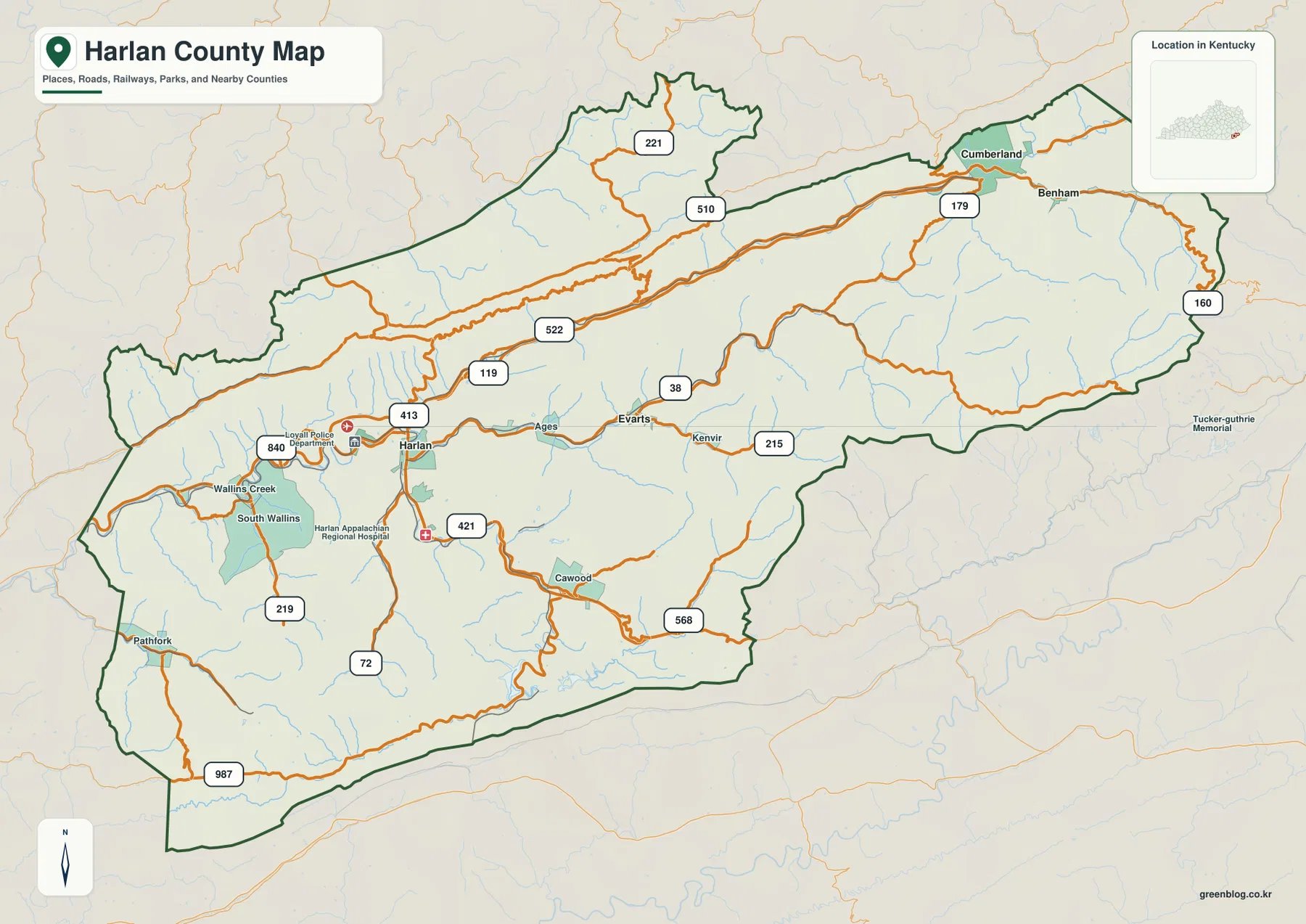
Harlan is the most useful starting point on the county map. US 119 approaches from Wallins Creek and Loyall, passes the Harlan area, and continues northeast toward Cumberland. US 421 comes through Harlan from the south near Cawood and continues north toward the Leslie County side. Several state routes, including KY 38, KY 72, KY 413, and KY 840, meet the larger highways around Harlan, so the city works as a practical reference when locating smaller communities and side valleys.
West of Harlan, Loyall, Wallins Creek, and South Wallins occupy the same general valley system, while Pathfork appears near the southwestern edge of the county. East of Harlan, KY 38 runs through Ages and Evarts toward the Virginia side. The road lines bend repeatedly because they follow usable valley floors rather than crossing every ridge directly. Looking at the road map together with the relief map helps explain why two places that seem close on a county outline may require a much longer route on the ground.
The northern and southern branches add another layer to the network. KY 221 and KY 510 leave the US 119 corridor for smaller mountain valleys in the north, while KY 215 and KY 568 serve the Cawood and Cranks Creek side of the county. In the east, KY 160 links the Cumberland area with Benham and Lynch. Kentucky Transportation Cabinet route information also identifies US 119 through Wallins Creek, Loyall, Harlan, and Cumberland, with US 421, KY 38, and KY 160 serving distinct mountain corridors.
Cumberland, Benham, and Lynch form a distinct eastern mountain cluster
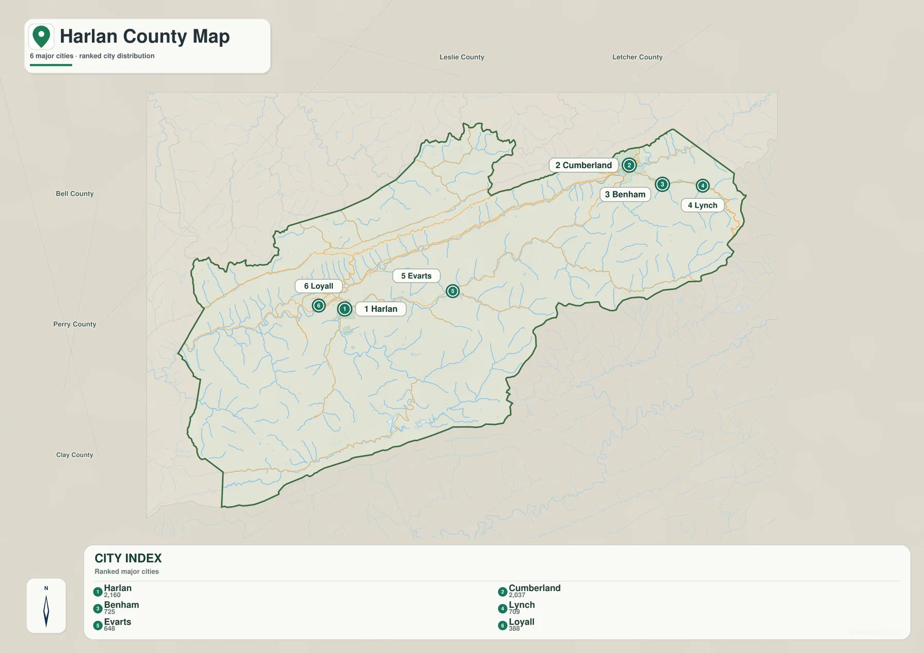
The city index highlights six principal cities: Harlan, Cumberland, Benham, Lynch, Evarts, and Loyall. Harlan and Loyall are close together in the central-western part of the county, and Evarts sits in a separate valley to the east along KY 38. Cumberland, Benham, and Lynch appear farther east as a tight group in the high mountains. Local tourism material commonly presents those three communities together as Harlan County’s Tri-Cities.
The eastern cluster is especially useful for understanding how settlement follows the land. US 119 reaches Cumberland along the Poor Fork Cumberland River valley, and KY 160 continues toward Benham and Lynch. The towns are geographically close, but the valley floor is narrow and steep slopes rise on both sides. On the elevation map, the surrounding ridges quickly climb into much higher terrain, making the line of communities along the lower corridor stand out clearly.
The city map is best used for this broad pattern rather than for detailed navigation. It shows where the six leading cities sit relative to one another without the visual clutter of every small road and settlement. Once the pattern is clear, the county map can be used to add places such as Ages, Kenvir, Cawood, Wallins Creek, and South Wallins. That two-step approach makes the county easier to follow than trying to learn every route number at once.
Cumberland River forks trace the valleys used by roads and communities
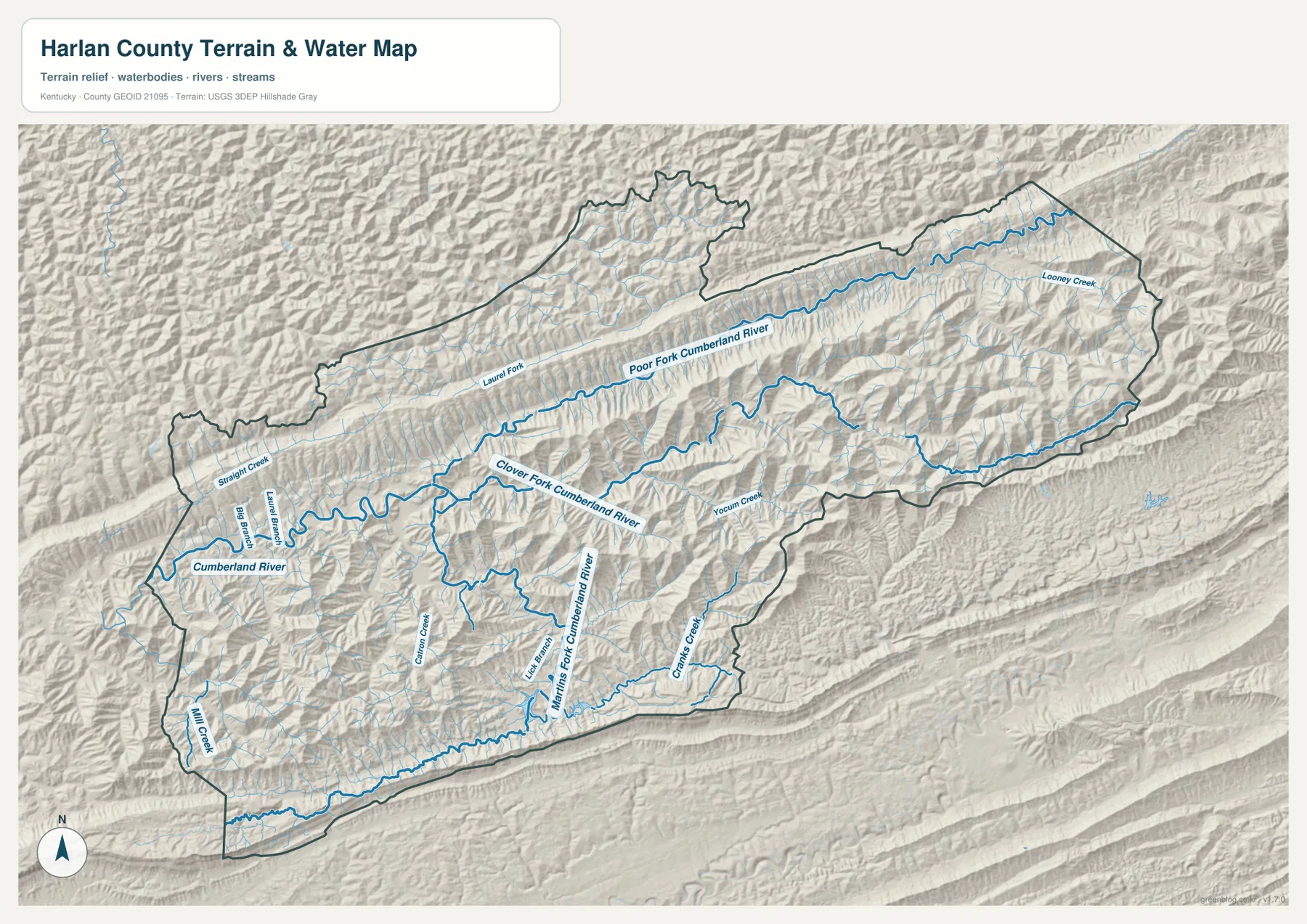
The terrain and water map shows how strongly Harlan County is organized by drainage valleys. The Cumberland River exits toward the west, while the Poor Fork Cumberland River, Clover Fork Cumberland River, and Martins Fork Cumberland River extend through different parts of the mountains. Numerous shorter tributaries branch from them, creating a dense pattern of narrow hollows and ridges rather than a single broad floodplain.
The Poor Fork follows the long northeastern valley toward Cumberland, while Looney Creek reaches the Benham and Lynch area. The Clover Fork runs through the central-eastern side of the county near the Evarts corridor, and the Martins Fork occupies another deep valley to the south. Cranks Creek, Yocum Creek, Mill Creek, and other named streams reveal additional side valleys that are easy to miss on a road-only map. These smaller waterways help explain why local roads often branch sharply away from the main highways.
Comparing the water map with the county map is particularly useful around KY 38 and KY 160. Those routes appear winding because they follow lower ground between steep slopes. The water layer is a static reference for the relative locations of rivers, creeks, and terrain; it should not be treated as a flood-hazard map, a legal water-boundary record, a real-time stream gauge, or a navigation chart. Current flood and water conditions require the appropriate official services.
A 326–1,259 m range reveals the county’s exceptional mountain relief
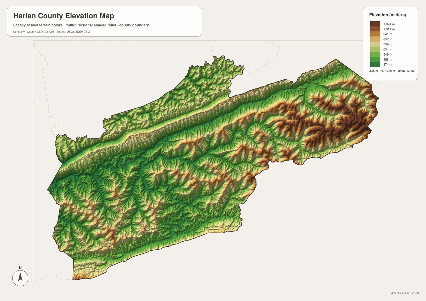
The elevation map reports an actual range of about 326 to 1,259 meters, with a mean elevation of 650 meters. Long ridges repeat across nearly the entire county, and the eastern and southeastern sections contain the broadest areas of high brown and tan relief. The Cumberland River and its major forks appear as lower green corridors between those ridges. With more than 900 meters of difference between the low and high ends of the map, Harlan County has one of the strongest relief contrasts among the Kentucky counties in this map series.
Black Mountain provides the best-known example of that high terrain. The Kentucky Energy and Environment Cabinet identifies a 4,139-foot point on Black Mountain as Kentucky’s highest point and places most of the upper mountain in eastern Harlan County near the Virginia line. The map’s maximum of 1,259 meters is roughly 4,130 feet, which is consistent with the very high terrain shown along the eastern border around the Black Mountain area.
The elevation map also clarifies the settlement pattern. Harlan, Loyall, Evarts, Cumberland, Benham, and Lynch all occupy lower corridors rather than the highest ridge crests, and the main roads generally follow the same terrain. Smaller roads that leave those valleys appear more winding as they climb or cross side ridges. This generalized elevation surface is designed for countywide comparison, not for determining the exact elevation of a building, parcel, engineering site, or survey point; detailed work should use original USGS elevation data or professional survey measurements.
Use Harlan, the Tri-Cities, and the river valleys as practical map anchors
A simple way to learn the county is to divide it around Harlan. To the west, Loyall, Wallins Creek, and Pathfork help orient the Cumberland River exit and southwestern valleys. To the east, US 119 leads toward Cumberland before KY 160 continues into Benham and Lynch. Evarts belongs to a different branch along KY 38, so treating it as its own valley corridor prevents the eastern communities from blending together when reading the map.
Harlan County tourism resources emphasize the same mountain setting through destinations such as the Black Mountain Off-Road Adventure Area, Portal 31, and Kingdom Come State Park. The Cumberland-Benham-Lynch area is especially closely tied to the county’s coal-mining history and high-elevation landscape. These references add local context to the map, but trail openings, park access, road conditions, and facility hours can change, so visitors should check the responsible agency or attraction before traveling.
For general orientation, the county map is the best choice because it combines communities, route numbers, and the boundary in one view. The city map is cleaner when the goal is to compare the positions of the six principal cities. The terrain and water map is more useful for finding named forks and creeks or understanding why a road follows a particular valley, while the elevation map makes the sharp contrast between river corridors and the Black Mountain high country immediately visible.
The WebP images are convenient for quick viewing on a screen, while the downloadable high-resolution JPG files are better when small road numbers, stream labels, or elevation colors need to be enlarged. Harlan County benefits especially from side-by-side comparison: pairing the county map with the water map explains valley-following roads, and pairing the county map with the elevation map shows why communities are concentrated in narrow lower corridors. Using the layers together gives a much clearer picture than expecting one map to show every detail equally well.
Frequently Asked Questions
Which road connects Harlan with Cumberland on the county map?
US 119 is the clearest main route between Harlan and Cumberland. West of Harlan, the same highway continues through the Loyall and Wallins Creek corridor, while KY 160 branches from the Cumberland area toward Benham and Lynch. The map is useful for route orientation, but current travel time, closures, and road conditions should be checked with live transportation information.
Why are Cumberland, Benham, and Lynch so close together?
The city map places all three communities in the eastern part of Harlan County, and the terrain and water map shows that they occupy a narrow mountain corridor associated with the Poor Fork Cumberland River and Looney Creek. The elevation map adds the reason the pattern is so tight: high ridges rise rapidly around the lower valley, leaving a relatively narrow band for towns and connecting roads.
How high does the Harlan County elevation map reach?
The supplied elevation map shows an actual range of roughly 326 to 1,259 meters and a mean elevation of 650 meters. The highest colors are concentrated in the eastern and southeastern mountains near the Virginia line, including the Black Mountain area. The map is generalized for countywide comparison, so precise site elevations should be checked with original USGS elevation data or a professional survey.
Map File Information
Download the Harlan County boundary and road map, city map, terrain and water map, and elevation map as high-resolution JPG files.
- Included Files: county map, city map, terrain and water map, elevation map
Related Maps
Sources and References
County government information is available from the Harlan County Judge/Executive and the Kentucky.gov Harlan County profile. Road references can be checked against the Kentucky Transportation Cabinet Harlan County map. For the high mountain landscape and Black Mountain, see the Kentucky Energy and Environment Cabinet Black Mountain Conservation Easement. Local Tri-Cities and visitor context is available through Harlan County tourism information, while source hydrography and elevation programs are documented by USGS National Hydrography and the USGS 3D Elevation Program.
Green Map creates custom-edited map images using open geographic data sources such as geoBoundaries, Natural Earth, OpenStreetMap, and government open data. These maps are edited visual materials, not raw data files, and are provided for education, documents, presentations, and graphic reference.