Edmonson County sits in south-central Kentucky, where Brownsville, the Green River, the Nolin River, and a dense pattern of ridges give the county a very different look from the flatter parts of western Kentucky. Brownsville is the clearest reference point near the center of the map, with KY 70 and KY 101 passing through the area. Routes 185, 187, 238, and 728 organize the north and northwest, while 259, 31W, and 65 appear near the southeastern edge. High-resolution map files are available for download in the section below.
This page combines county boundaries and roads, the major-city view, waterways and shaded terrain, and elevation in a set designed for both quick reference and closer study. High-resolution JPG originals of all four maps are available together in one ZIP, which is useful when small route shields, creek names, or terrain colors need to be enlarged or printed. These maps are regional reference materials rather than substitutes for live navigation, legal boundary research, flood decisions, or survey-grade measurements.
Table of Contents
Brownsville anchors a road network shaped by valleys and ridges
Brownsville is the strongest place marker on the general county map. KY 70 runs east from the city toward the Chaumont and Cave City side, while KY 101 heads south. To the northwest, KY 187 and KY 238 split across the interior, and KY 185 appears near the western boundary. KY 728 crosses the north-central part of the county. Instead of one major highway dominating local travel, several state routes bend through a landscape cut by short ridges and stream valleys.
The southeastern corner has a different road pattern. U.S. 31W and KY 65 lie near the boundary, with KY 259 linking back toward the interior. Park City and Cave City appear just beyond the county line, so this part of the map is useful for understanding how Edmonson County connects toward the Mammoth Cave and Barren County side. Farther north, Cub Run is labeled near the upper edge, while Slaty Bank appears as a historical place name in the northwest.
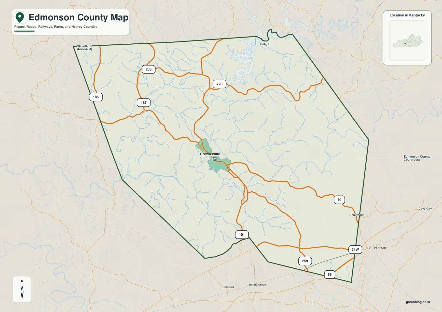
The county boundary is irregular rather than rectangular, especially along the north and east. Grayson County is shown to the north, Hart and Barren counties to the east, and Warren and Butler counties to the west. Reading those neighboring labels with the road map helps place Edmonson County within the interior of Kentucky instead of treating Brownsville as an isolated point.
The curving roads also make more sense when the terrain is considered. Many local routes follow valleys or cross between short ridge systems, so their paths often change direction over relatively short distances. This static map is good for understanding which communities and corridors connect to one another, but current construction, closures, and driving times should always be checked with an up-to-date transportation source.
Why the city map reduces the county to one major center
The city map deliberately removes most smaller place labels and highlights Brownsville as the only ranked major city. Its CITY INDEX shows Brownsville in the first position with a displayed value of 1,068. Because the image does not identify the statistical year or definition behind that figure, it is safer to treat it as part of the supplied city index rather than present it as a current official population count.
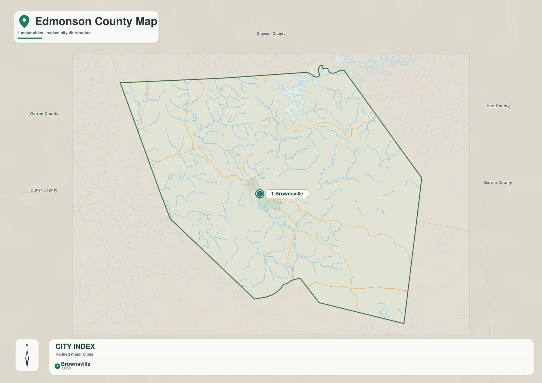
Brownsville is also an important civic reference point. The official Edmonson County site maintains a dedicated City of Brownsville page with municipal information, and the general map shows roads concentrating around the same area. That combination of road access and civic function explains why Brownsville stands out much more clearly than the county’s smaller named places.
A one-city map does not mean that the rest of Edmonson County is empty. Cub Run, Chaumont, Slaty Bank, and numerous rural road corridors appear on the more detailed county map, while Park City and Cave City provide useful external reference points near the southeast. The city map is best when a clean regional locator is needed; the county map is better when road numbers and smaller places matter.
The Green and Nolin rivers define the county’s clearest natural corridors
The terrain-and-water map makes the Green River and Nolin River the dominant natural features. The Green River enters from the west and bends through the southwestern and central county. The Nolin River descends from Nolin River Lake in the north before winding into the interior. Both rivers occupy low, sinuous valleys, and the shaded relief shows short ridges rising quickly on either side.
Nolin River Lake is the largest named water body on the map. Around it and across the northwestern interior, Big Reedy Creek, Sunfish Creek, and Bear Creek form smaller tributary corridors. Byler Creek and Wet Prong appear farther east, while Honey Creek, Alexander Creek, and Beaver Dam Creek are labeled in the southern half. Echo River stands out on the eastern side. Together, these waterways show how strongly the county is divided by branching valleys.
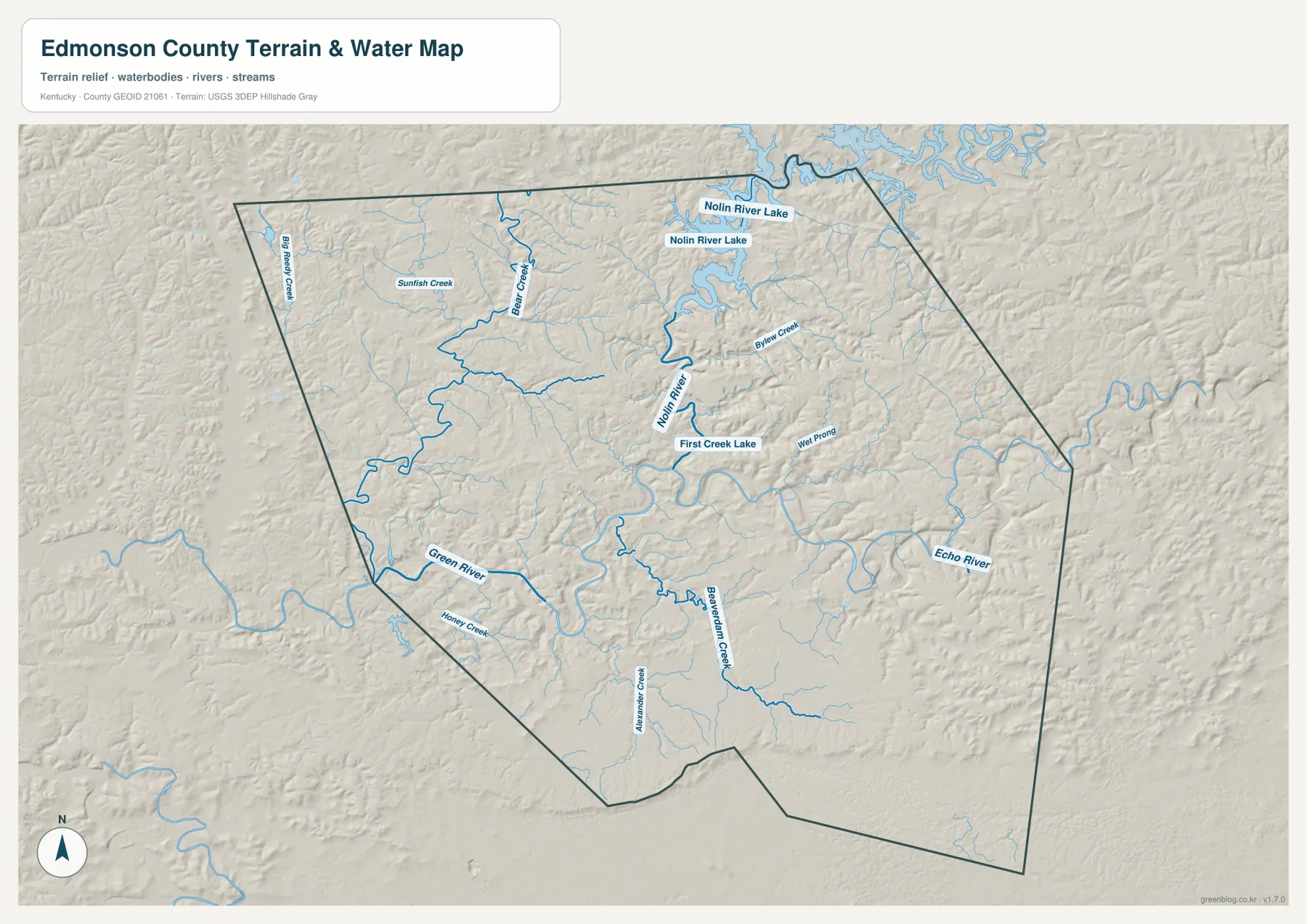
First Creek Lake is another useful local reference point near the central part of the map. The shaded terrain around it shows a recurring pattern: a lower stream corridor surrounded by closely spaced ridges. That pattern appears across much of Edmonson County, so the water map is especially useful for understanding why roads and settlements often occupy narrow, curving corridors rather than broad straight alignments.
Mammoth Cave National Park adds important regional context. The National Park Service states that the park covers land in Edmonson, Hart, and Barren counties and protects the Green and Nolin rivers along with a forested karst landscape. Karst terrain develops where soluble rock such as limestone allows caves, sink features, and underground drainage to form. The map on this page, however, does not show cave passages, flood zones, water depth, navigability, or public-access rights.
A 124–279 meter elevation range separates river valleys from eastern ridges
The elevation map reports an actual range of about 124 to 279 meters, with a mean near 193 meters. Green shades mark the lower ground, while yellow and brown represent higher terrain. The lowest bands closely follow the Green River and Nolin River, and another low corridor wraps around Nolin River Lake. The match between river courses and lower elevation colors is one of the clearest patterns on the map.
Higher terrain is most continuous in the east and northeast, where brown ridge bands become tightly packed. Those ridges rise sharply above nearby stream valleys. The northwest and west are not flat, but their ridge pattern is generally less continuous than the high eastern side. South-central Edmonson County contains a mixture of moderate uplands and lower drainage corridors, so the county does not simply rise in one steady direction.
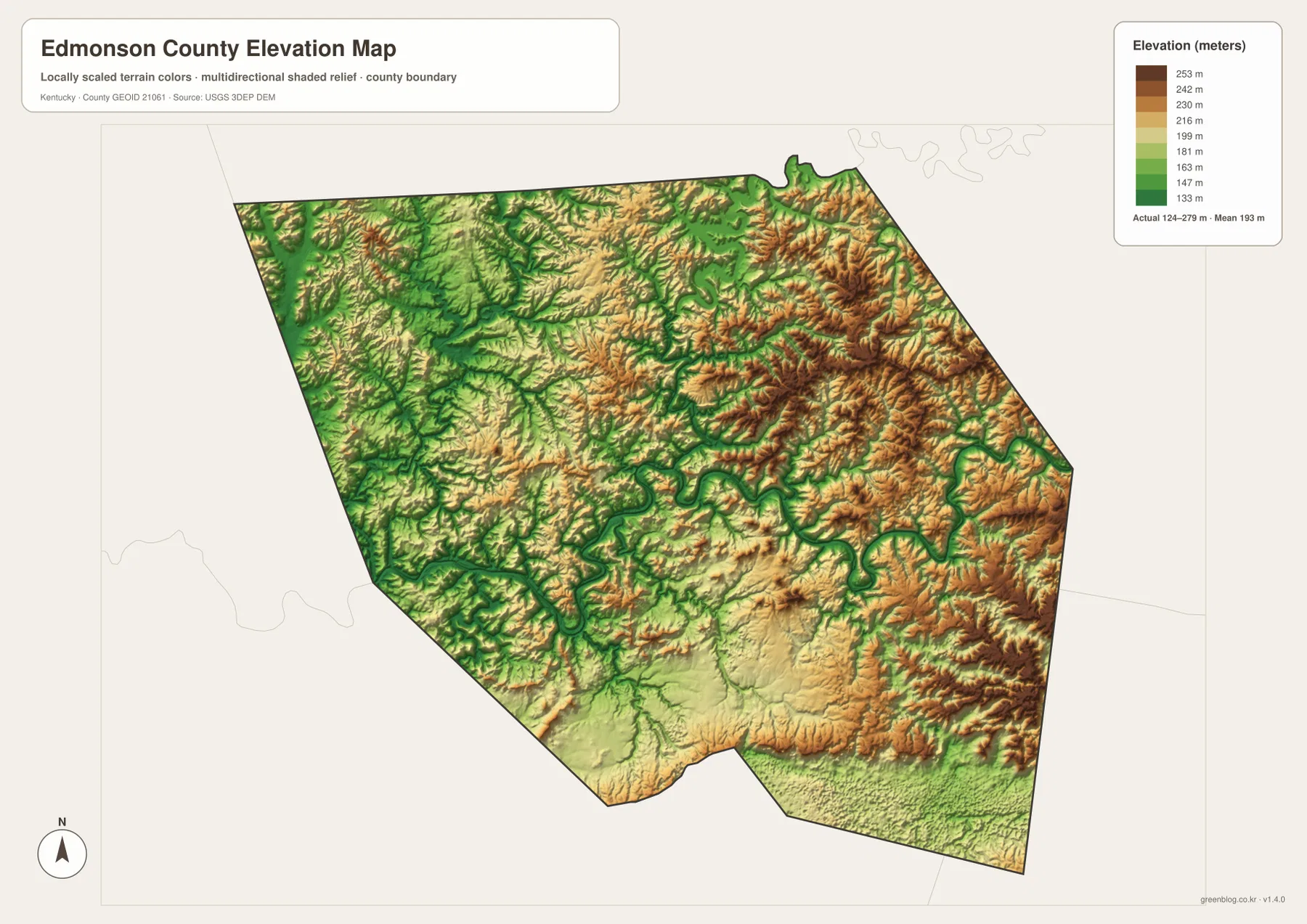
The difference between the mapped low and high values is about 155 meters. Edmonson County is not a high mountain county, yet repeated short climbs from valley floor to ridge top make the landscape look strongly dissected. That relief also helps explain why tributaries approach the larger rivers from many directions and why road alignments often bend around slopes instead of crossing the county in straight lines.
The elevation surface is generalized for county-scale comparison. It should not be used to determine the exact height of a house, parcel corner, bridge, trail point, or construction site, and it is not an engineering or flood-analysis product. Detailed elevation work should rely on USGS 3D Elevation Program data or a professional survey appropriate to the task.
Choosing the right map for Brownsville, Mammoth Cave country, and the river valleys
Use the general county map when you need Brownsville together with route numbers such as KY 70, 101, 185, 187, 238, and 259 or U.S. 31W. It is the strongest choice for tracing how the central county connects toward Cub Run, Chaumont, Park City, Cave City, and neighboring counties. The city map works better for a presentation or quick locator where Brownsville and the surrounding county names need to remain visually simple.
The terrain-and-water map is the better choice for the Green River, Nolin River, Nolin River Lake, Echo River, and the smaller creek network. Because shaded relief is included, it also shows how the waterways sit inside narrow valleys. The elevation map simplifies that same landscape into a height comparison, making the 124–279 meter range and the concentration of higher ridges in the east easier to compare at a glance.
All four original files are 3638 × 2572 pixel JPG images. The WebP versions displayed in the article are optimized for browser viewing, while the downloadable originals are more convenient for printing or enlarging small route shields, waterway labels, and elevation colors. They are suitable for classroom work, presentations, personal reference, and regional orientation, but legal, emergency, engineering, and live travel decisions should use current authoritative sources.
Frequently Asked Questions
Which map is best for following roads around Brownsville?
The general county map is the best starting point because it combines Brownsville with KY 70, KY 101, KY 185, KY 187, KY 238, KY 259, U.S. 31W, and other labeled routes. It also keeps the county boundary and smaller places visible, which makes it easier to compare local road directions.
Where can I see Nolin River Lake in relation to the Green River?
The terrain-and-water map gives the clearest comparison. Nolin River Lake is in the north, the Nolin River runs south from it, and the Green River bends through the western and central county. Smaller tributaries such as Big Reedy Creek, Bear Creek, Byler Creek, and Echo River are labeled as well.
What files are included in the downloadable ZIP?
The ZIP contains high-resolution JPG originals for the county map, city map, terrain-and-water map, and elevation map. Each image is 3638 × 2572 pixels, so the original files are better than the smaller on-page WebP versions for printing and close label inspection.
Map File Information
The four Edmonson County maps used on this page are available as high-resolution JPG originals in one ZIP. The larger files are better suited to printing and close inspection of road numbers, waterway names, and elevation colors than the WebP display images.
- Included Files: county map, city map, terrain and water map, elevation map
- File Type: JPG
Related Maps
Sources and references
Municipal information is available from the official Edmonson County City of Brownsville page, and regional cave, river, and karst context is documented by the National Park Service at Mammoth Cave National Park. Administrative boundary data are available from U.S. Census Bureau TIGER/Line Shapefiles, hydrography from USGS National Hydrography, and terrain data from the USGS 3D Elevation Program. Use current agency information for road conditions, park access, water levels, hazards, and legal boundaries.
Green Map creates custom-edited map images using open geographic data sources such as geoBoundaries, Natural Earth, OpenStreetMap, and government open data. These maps are edited visual materials, not raw data files, and are provided for education, documents, presentations, and graphic reference.