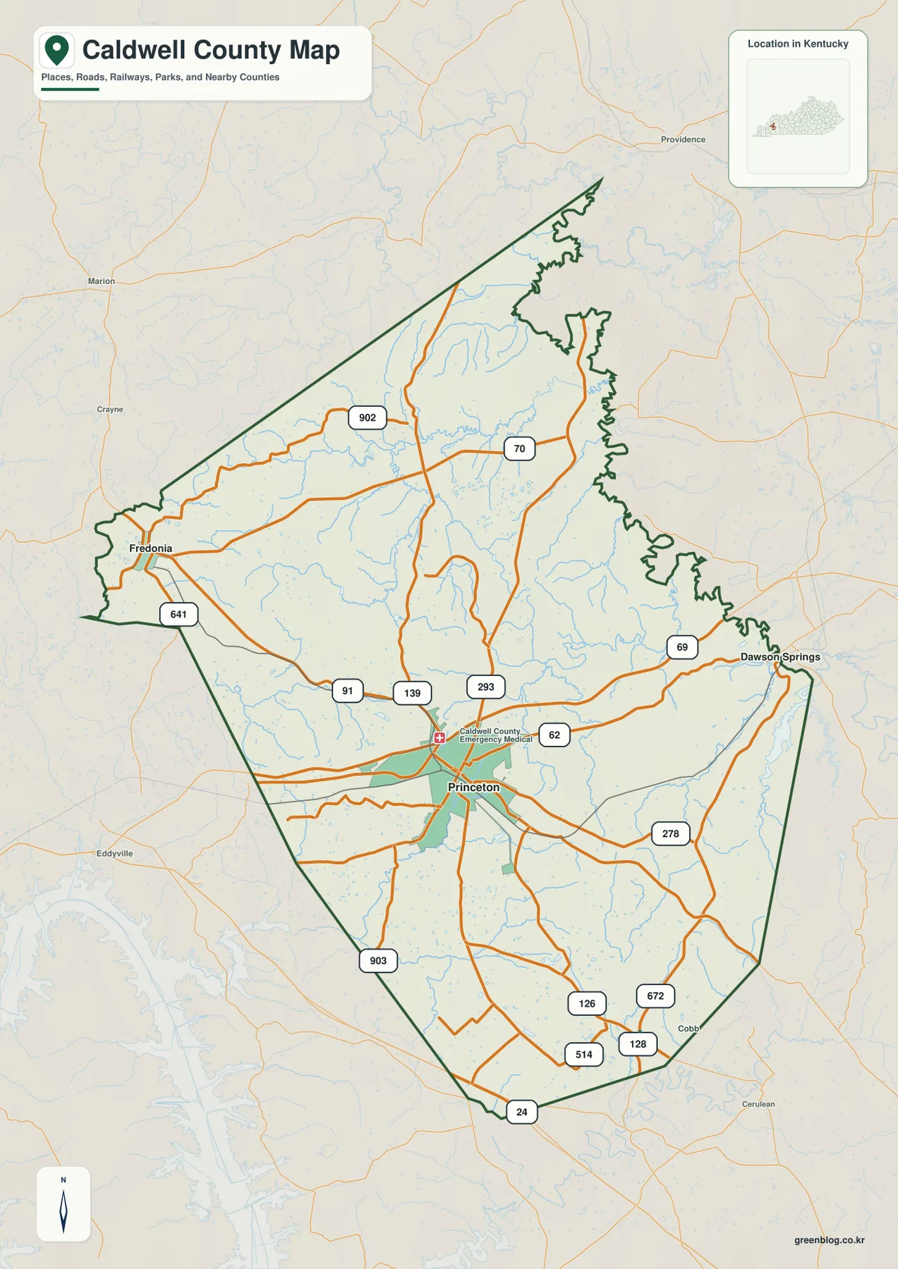
Caldwell County in western Kentucky is easiest to understand from Princeton, where several state routes converge near the south-central part of the county. Fredonia provides a second reference point near the western edge, while the road network reaches toward Dawson Springs at the east side and into neighboring counties in every direction. The county map shows KY 91, KY 139, KY 62, KY 293, KY 902, and other routes crossing a landscape cut by many small creeks rather than one dominant river. Those roads, streams, and a 101–233 meter elevation range give the county a distinctly rolling appearance on the four supplied maps.
The map files on this page can also be downloaded as high-resolution JPG originals. The reference map is the best choice for roads and boundaries, the city map reduces the view to Princeton and Fredonia, the water layer highlights named creeks and small lakes, and the elevation layer separates lower valleys from higher ridges. The files work well for printing, classroom projects, local orientation, and presentations. They are not substitutes for parcel surveys, flood maps, engineering elevation data, or live navigation, so those uses should rely on the appropriate current agency products.
Table of Contents
Princeton forms the road hub while Fredonia anchors the western side
Princeton is the clearest organizing point on the county reference map. KY 91 approaches from the west and continues through the broader road network around town, KY 139 runs north and south, and KY 62 heads east toward the Dawson Springs side of the county. KY 293 appears close to the central junction area, adding another north-south connection. Once Princeton is located, the smaller routes are easier to place because most of them can be described by how they sit relative to this central cluster.
Fredonia sits much farther west, close to the county boundary, with KY 91 and KY 641 providing useful orientation nearby. KY 902 crosses the northwestern part of the county, while KY 70 is visible across the northern interior. The southeastern half has a denser scatter of route numbers, including KY 278, KY 126, KY 672, KY 128, and KY 514. KY 24 reaches the southern edge, and KY 903 provides another southern connection. The pattern is not a simple grid: local routes bend between creek valleys and low ridges before reaching the larger roads.
The outer boundary also helps explain the county’s unusual shape. A long narrow section reaches northward, while the eastern line is noticeably irregular. The city map labels Crittenden County to the north, Hopkins County to the east, Christian County to the southeast, Trigg County to the southwest, and Lyon and Webster Counties on the western side. Using those names as directional references is more useful than treating Caldwell County as a rectangular area because the actual boundary changes direction several times.
The simplified city map emphasizes only two ranked places. Its city index labels Princeton at 6,241 and Fredonia at 466, showing a strong difference in the values used for this map. Those figures are best read as the map’s own city-index labels rather than assumed to be current population estimates. Princeton lies near the south-central road concentration, whereas Fredonia is separated from it by a broad rural interior. This makes the city map useful when the detailed route labels on the reference map are more information than a reader needs.
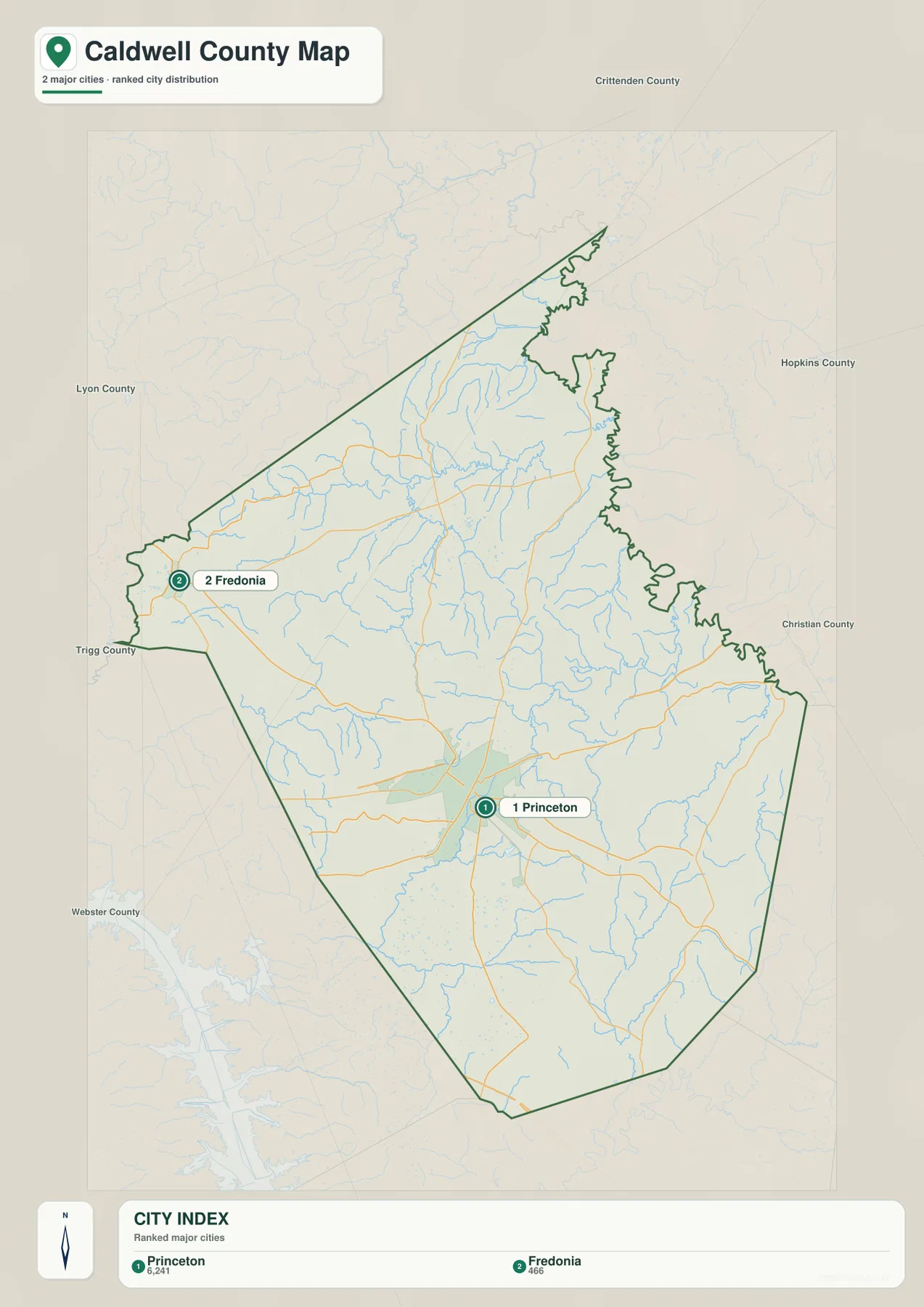
For orientation, the two maps work best as a pair. The city view answers the quick question of where Princeton and Fredonia sit inside the boundary. The reference map then adds route numbers, smaller roads, the eastern approach to Dawson Springs, and the many streams that cross the interior. Drivers still need current routing information for actual travel, but the county map makes it easier to understand why a trip between two nearby points may not follow a perfectly straight line.
Donaldson Creek and a web of tributaries divide the interior
The terrain-and-water map is dominated by branching creeks rather than a single large river. West Fork Donaldson Creek enters the northwestern interior and sits near Donaldson Creek, which continues across the upper half of the county. Numerous smaller branches feed those channels from short side valleys. Farther east, Flynn Fork and Ward Creek create another set of recognizable drainage corridors. The result is a landscape where water lines repeatedly cut across the rolling ground and separate one ridge from the next.
The southern and eastern parts of Caldwell County contain their own named waterways. Montgomery Creek runs through the southeast, while Goose Creek and Eddy Creek are labeled closer to the south-central interior. Millwood Creek appears farther southeast, Dry Creek crosses the lower part of the map, and Skinframe Creek is marked toward the western interior. These names are useful reference points because they spread across different sections of the county instead of clustering around one central water body.
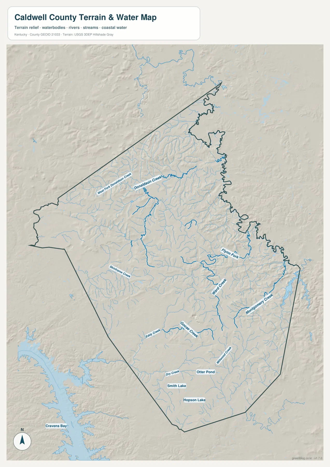
Three small named water bodies provide additional southern landmarks: Smith Lake, Hopson Lake, and Otter Pond. They are much smaller than the broad reservoir and bay features visible outside the county boundary to the southwest, so the dark boundary line matters when reading the map. A label such as Cravens Bay appears beyond Caldwell County and should not be treated as an internal county feature. For print use, keeping the county outline visible is the simplest way to separate local water features from those in neighboring areas.
The creek network also gives context to the road pattern. Routes around Princeton cross several small drainage lines, and roads in the northern and eastern uplands often change direction between narrow valleys. A straight road would frequently have to cross both a stream and the ridge beside it, so local connections tend to follow terrain where practical. The map is not detailed enough to identify every bridge or culvert, but it is useful for seeing the broad relationship between roads, valleys, and the branching waterways.
This water layer is intended for geographic reference only. It does not show flood zones, current stream stage, water quality, public access, private property, or boating conditions. Anyone making a safety or property decision should use the relevant current agency data. For authoritative hydrography, the USGS National Hydrography program is a useful source for the underlying water-network context.
A 101–233 meter relief pattern alternates creek valleys and short ridges
The elevation map reports an actual range of about 101 to 233 meters, with a mean near 153 meters. Green shades represent the lower portions of the county, while yellow, tan, and brown mark progressively higher ground. Caldwell County does not contain one continuous mountain mass. Instead, clusters of higher ridges are separated by lower creek valleys, creating a repeated up-and-down pattern across the interior.
The long northern extension contains broad lower-colored areas, but immediately south and west of it several brown ridge clusters stand out. More elevated patches appear again through the eastern and southeastern interior. The south-central section contains wider areas of moderate or lower relief, especially around some of the small drainage corridors. Because the high ground is broken into separate ridges rather than one continuous belt, elevation can change noticeably over short distances without the county feeling mountainous on a regional scale.
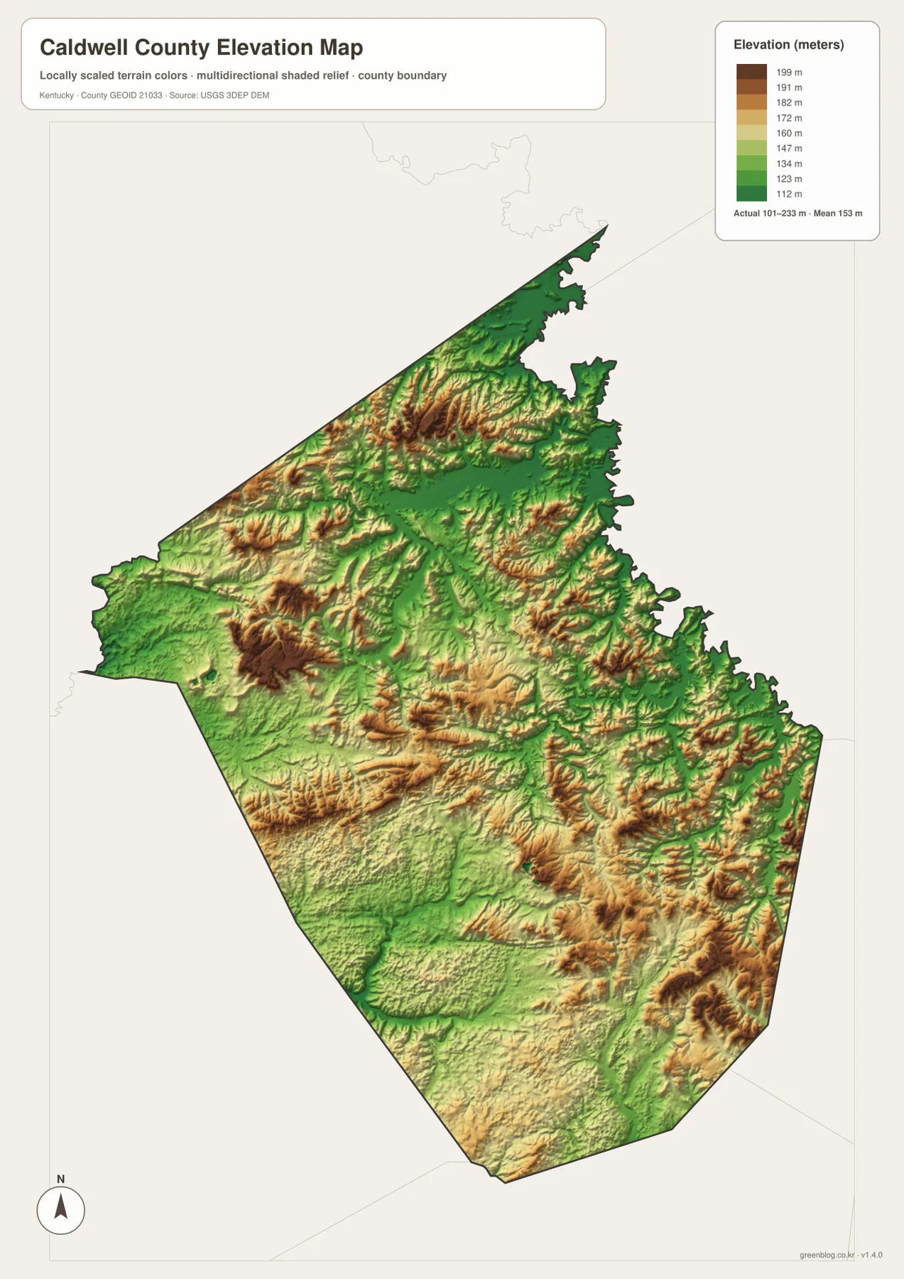
Comparing the water and elevation maps reveals the relationship more clearly. Donaldson Creek and Ward Creek occupy lower corridors between nearby ridges, and the same general pattern appears around Goose Creek and Montgomery Creek. The creeks do not follow identical elevation colors at every point because the surface is generalized, but the broad match between drainage lines and valleys is easy to see. This comparison helps explain why the road map contains so many curves and angled junctions outside the Princeton area.
The elevation surface should be treated as a countywide comparison layer, not as survey-grade measurement. It is suitable for recognizing lower valleys, relative ridge heights, and the overall relief pattern. A building lot, road grade, drainage plan, construction project, or legal survey requires more precise elevation information and, where appropriate, field measurements. The USGS 3D Elevation Program is a better starting point for those higher-precision needs.
Matching each map to the question you need to answer
For a first look at Caldwell County, start with Princeton on the reference map and trace KY 91, KY 139, and KY 62 outward. Then use Fredonia on the city map to establish the western side of the county. This simple sequence gives a reader a practical mental frame before adding smaller roads, boundary bends, and drainage names. The surrounding county labels are especially useful when a project needs regional orientation rather than just an isolated outline.
For physical geography, choose one or two named creeks and compare them across the water and elevation layers. Donaldson Creek is a good northern reference, Ward Creek works well in the central-eastern interior, and Montgomery Creek helps anchor the southeast. The low colors along many drainage corridors contrast with nearby ridges, making it easier to explain why the county contains many short slopes instead of one broad flat plain.
For printing, the reference map is the strongest choice when route numbers and neighboring places matter. The city map is cleaner when only Princeton and Fredonia need to be emphasized. The water map is better for named streams, Smith Lake, Hopson Lake, and Otter Pond, while the elevation map is the clearest way to show the difference between creek valleys and upland ridges. Since all four maps share the same county boundary, they can be compared without changing the geographic frame.
Caldwell County’s official government site describes the county as part of Kentucky’s western Pennyrile region and notes its long local history. That regional setting fits the mapped landscape: rolling uplands, numerous creeks, small communities, and roads that connect outward toward several neighboring counties. The maps on this page focus on geography rather than administrative services, but the county site is a useful companion source when a reader needs local government or historical context.
Frequently Asked Questions
Where are Princeton and Fredonia located within Caldwell County?
Princeton sits near the south-central road hub, while Fredonia is near the western boundary. The reference map shows KY 91 as an important westward route in that relationship, while the city map provides a cleaner view of the two places without the full road detail. Driving distance and travel time are not shown on the city map and should be checked with current routing data.
Which named waterways appear besides Donaldson Creek?
The water map labels West Fork Donaldson Creek, Flynn Fork, Ward Creek, Montgomery Creek, Goose Creek, Eddy Creek, Millwood Creek, Dry Creek, and Skinframe Creek. Smith Lake, Hopson Lake, and Otter Pond are also labeled in the southern part of the county. The layer is for geographic reference and does not provide flood, access, or current water-condition information.
Can the 101–233 meter elevation map be used for surveying or construction?
No. The elevation map is designed to compare lower valleys with higher ridges across the county. Surveying, building design, road grading, drainage engineering, and legal property work require more precise authoritative elevation data and, when necessary, field measurements.
Map File Information
The original Caldwell County maps used in this article are packaged as high-resolution JPG files. Each source image is 3638 × 2572 px, providing more detail than the WebP previews for printing and document work.
- Included Files: county reference map, city map, terrain-and-water map, elevation map
- File Type: JPG
Related Maps
Sources and references
Local government and historical context are available from the official Caldwell County website. Boundary reference data are available through the U.S. Census Bureau TIGER/Line program, hydrography through USGS National Hydrography, and elevation data through the USGS 3D Elevation Program.
Green Map creates custom-edited map images using open geographic data sources such as geoBoundaries, Natural Earth, OpenStreetMap, and government open data. These maps are edited visual materials, not raw data files, and are provided for education, documents, presentations, and graphic reference.